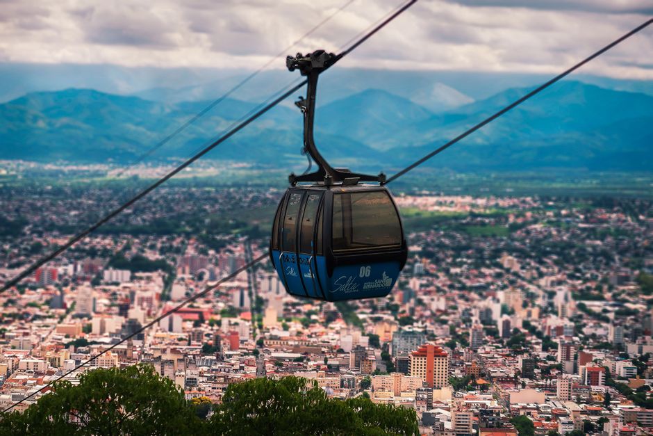
Salta, nicknamed “Salta la Linda” (Salta the beautiful), is the capital of Salta province in Argentina’s north-west, a colonial city of white and ocher churches, arcaded squares and wooden balconies in the green Lerma Valley at about 1,150 m (3,800 ft). It is the base for some of Argentina’s most spectacular road trips: south through red canyons to the high vineyards of Cafayate, west over the Cuesta del Obispo to Cachi and the cactus forests of Los Cardones National Park, and north into Jujuy’s multicolored Quebrada de Humahuaca, a UNESCO World Heritage Site, and the white Salinas Grandes salt flats. The region’s Andean culture, folk music, empanadas and Torrontés white wine make it feel very different from Buenos Aires. Visit from April to November, outside the summer rains.
Right now in Salta
- Tue 12–24°C 53–76°F Mostly clear
- Wed 11–28°C 52–82°F Mostly clear
- Thu 15–20°C 58–68°F 7 mm Light rain
- Mon 12 Oct Day of Respect for Cultural Diversity (Día del Respeto a la Diversidad Cultural)
Weather: MET Norway (CC BY 4.0) · Air quality: OpenAQ · Holidays: Nager.Date
Top tours in Salta
See all tours for Salta →
From local operators, with prices and reviews; you check availability and book on Viator, our partner. We may earn a commission at no extra cost to you. How we earn money
Salta at a glance
- Best for: colonial architecture, road trips through canyons and valleys, high-altitude wine, Andean culture, folk music and archaeology.
- How long: 2 days for the city; 5–8 days with Cafayate, Cachi and the Quebrada de Humahuaca.
- Best time: April to November, dry and sunny, with highs of about 20–27 °C (68–80 °F); summer (December to March) is the rainy season, with storms and occasional road closures.
- Getting there: Salta’s Martín Miguel de Güemes airport (SLA), about 2 hours by air from Buenos Aires.
- Before you go: entry rules, money and general safety are in our Argentina travel guide.
Salta’s center: where things are
The historic center is a compact grid around the Plaza 9 de Julio, the main square, lined with cafés under arcades. On its sides stand the pink-and-cream Cathedral, the white colonial Cabildo (town hall) and the MAAM museum. A few blocks east, the red-and-gold Church of San Francisco is the city’s postcard, and the Cerro San Bernardo rises behind the center, with a cable car to its summit. Calle Balcarce, north of the center near the old train station, is the nightlife street, with peñas and bars.
Salta’s neighborhoods and nearby towns
- The historic center: the blocks around the Plaza 9 de Julio and the pedestrian streets Florida and Alberdi, with churches, museums, shops and cafés; the obvious base.
- Calle Balcarce and the old station: north of the center, the nightlife zone of peñas, bars and a weekend craft fair.
- Tres Cerritos and the north: leafy residential streets with restaurants, near the base of Cerro San Bernardo.
- San Lorenzo: a green village in the hills about 10 km (6 miles) west, with estancias, walks in the Quebrada de San Lorenzo and quieter hotels.
- Cafayate and Cachi: the valley towns where most visitors spend at least one night on a road trip.
Top things to see in Salta
MAAM, the Museum of High Mountain Archaeology
The Museo de Arqueología de Alta Montaña tells the story of the Llullaillaco children, three Inca children left as offerings on the summit of the Llullaillaco volcano, at 6,739 m (22,110 ft), about 500 years ago and found in 1999, extraordinarily preserved by the cold. One of them is shown at a time, in a refrigerated case; the museum treats them with respect, and some visitors prefer to skip that room.
The Cathedral and the Church of San Francisco
The Cathedral holds the images of the Lord and Virgin of the Miracle, the focus of the Fiesta del Milagro each September, when hundreds of thousands of pilgrims arrive. The Church of San Francisco has a tall, ornate bell tower.
Cerro San Bernardo
Ride the cable car (teleférico) from Parque San Martín, or climb the 1,070 steps, to gardens and a viewpoint over the city and valley.
More to see
- The Cabildo: the colonial town hall, now a history museum.
- Convento de San Bernardo: the oldest religious building in Salta, with a carved wooden door.
- Pajcha Museum: a private museum of Andean folk art.
- Mercado Artesanal: handicrafts in a colonial building west of the center, including ponchos in the red Salta style.
Other things to do in Salta
Peñas and folk music
Salta is the home of Argentine folk music (folklore): at a peña, musicians play zambas and chacareras on guitars and bombos (drums) while diners eat empanadas and locals sometimes dance. Most are on Calle Balcarce and around the center and get going late.
Food and wine
Try empanadas salteñas (small, juicy and baked), humita and tamales made from corn, locro (a hearty stew) and llama meat. Torrontés, a fragrant white wine, comes from the high vineyards of Cafayate. See our guide to wine tasting.
Road trips and day trips from Salta
Many visitors rent a car for the loop through Cafayate and Cachi; tours run daily for those who prefer not to drive. Parts of the roads are gravel, and summer rains can cause landslides and river crossings to close.
- Cafayate and the Quebrada de las Conchas: about 185 km (115 miles) south, 3.5–4 hours, through a canyon of red sandstone formations such as the Garganta del Diablo and the Anfiteatro. Cafayate, at about 1,700 m (5,600 ft), is a relaxed wine town with bodegas you can walk to.
- Cachi and Los Cardones National Park: about 160 km (100 miles) west, over the Cuesta del Obispo pass at about 3,350 m (11,000 ft) and across the straight Recta del Tin Tin through Los Cardones National Park, a landscape of giant candelabra cacti. As of October 2026, foreign visitors pay ARS 25,000 (about US$16) per day at the park, under the National Parks Administration’s fee table. Cachi is a white adobe village at about 2,300 m (7,500 ft). The loop Salta–Cachi–Cafayate–Salta takes at least two to three days, partly on gravel Route 40.
- The Quebrada de Humahuaca: about 1.5 hours north to San Salvador de Jujuy, then up a colorful valley to Purmamarca and its Hill of Seven Colors, Tilcara with its Pucará fortress, and Humahuaca at about 2,950 m (9,700 ft). Best as an overnight trip.
- Salinas Grandes: salt flats at about 3,450 m (11,300 ft), reached from Purmamarca over the Cuesta de Lipán, which climbs above 4,100 m (13,500 ft).
- Tren a las Nubes: the “Train to the Clouds” runs a tourist service on a high section of the Salta–Antofagasta railway from San Antonio de los Cobres to the La Polvorilla viaduct at about 4,200 m (13,800 ft); most visitors travel by bus from Salta and ride the train on the high part. Check schedules and the altitude advice before booking.
More road trips
- San Antonio de los Cobres: a windswept mining town on the high plateau at about 3,775 m (12,400 ft), on the Tren a las Nubes route and Route 51 toward Chile.
- Molinos and Seclantás: colonial villages on Route 40 between Cachi and Cafayate, known for ponchos woven on looms by the roadside.
- Iruya: a remote village clinging to a mountainside, reached by a dramatic gravel road from Humahuaca; best as an overnight.
- Calilegua National Park: cloud forest (yungas) in Jujuy province, with birds and trails, a contrast to the dry valleys.
Getting there and getting around
- By air: Salta’s airport (SLA), about 10 km (6 miles) south-west of the center, has flights from Buenos Aires (about 2 hours) and other cities; taxis and remises run to town.
- By bus: long-distance buses run from Buenos Aires (about 20 hours), Mendoza, Córdoba and Jujuy, and to San Pedro de Atacama in Chile over the Paso de Jama.
- Getting around: the center is walkable; taxis and city buses cover the rest. For road trips, rent a car (a higher-clearance car helps on gravel) or join tours.
Getting around: practical details
City buses (with a local rechargeable card) and inexpensive taxis cover Salta; the teleférico to Cerro San Bernardo leaves from Parque San Martín. For road trips, rental cars are available in the city and at the airport; ask for one allowed on gravel and check the spare tire. Route 68 to Cafayate is paved; the Cachi road over the Cuesta del Obispo is paved most of the way, but Route 40 between Cachi and Cafayate is largely gravel, slow and dusty, with river fords that can flood in summer. Buses run to Cafayate several times a day and to Cachi less often, and to Jujuy and the Quebrada de Humahuaca frequently. Organized day tours leave early, around 7 a.m.
When to go and how long to stay
Salta has a mild highland climate with a dry winter and a rainy summer: almost all its rain falls from November to March, in afternoon and evening storms. The table uses the National Meteorological Service’s 1991–2020 normals for the Salta airport station (1,221 m), as published by the World Meteorological Organization.
| Season | Average high / low | Rainy days per month | What it’s like | Good for |
|---|---|---|---|---|
| Summer (Dec–Feb) | 26–28 °C (80–83 °F) / 16–17 °C (61–62 °F) | 10–12 | Warm and green, with frequent storms; roads can close | Carnival in the Andean villages, lush valleys |
| Fall (Mar–May) | 25 °C falling to 20 °C (77 to 69 °F) / 15 °C falling to 8 °C (59 to 47 °F) | 2–10 | Drying out, golden light; the grape harvest in Cafayate | Road trips, wine |
| Winter (Jun–Aug) | 20–23 °C (68–73 °F) / 3–5 °C (37–41 °F) | under 1 | Dry and sunny; freezing nights in the high valleys | Road trips, the Quebrada, clear skies |
| Spring (Sep–Nov) | 25 °C rising to 28 °C (76 to 82 °F) / 8 °C rising to 14 °C (46 to 58 °F) | 1–7 | Warm and dry until the rains return in November | Road trips, the Fiesta del Milagro in September |
The airport station records about 740 mm (29 in) of rain a year, about 80% of it from December to March; January is the wettest month, with about 200 mm (8 in).
Salta month by month
Average daily highs and lows at the Salta airport station (SMN 1991–2020 normals, via the WMO).
| Month | High / low | What to expect |
|---|---|---|
| January | 28 °C (82 °F) / 17 °C (62 °F) | Wettest month, storms; summer holidays |
| February | 27 °C (80 °F) / 16 °C (61 °F) | Rainy; Carnival in the Quebrada de Humahuaca |
| March | 25 °C (77 °F) / 15 °C (59 °F) | Rain easing; grape harvest in Cafayate |
| April | 23 °C (73 °F) / 12 °C (54 °F) | Green valleys, dry roads return; great time |
| May | 20 °C (69 °F) / 8 °C (47 °F) | Dry and sunny, cool nights |
| June | 20 °C (68 °F) / 5 °C (40 °F) | Dry winter, cold high valleys |
| July | 20 °C (68 °F) / 3 °C (37 °F) | Winter school holidays; clear skies |
| August | 23 °C (73 °F) / 5 °C (41 °F) | Dry and windy; Pachamama offerings on August 1 |
| September | 25 °C (76 °F) / 8 °C (46 °F) | Fiesta del Milagro, peaking September 15 |
| October | 27 °C (80 °F) / 12 °C (54 °F) | Warm and mostly dry |
| November | 28 °C (82 °F) / 14 °C (58 °F) | First storms; green-up begins |
| December | 28 °C (83 °F) / 16 °C (61 °F) | Hot, rainy afternoons |
Crowds: the city fills for the Fiesta del Milagro (culminating on September 15), the July winter school holidays, Easter and Carnival (in February or March), when the Quebrada de Humahuaca’s villages hold big celebrations.
4 days in Salta
Day one, the center, the MAAM and the Cathedral, and a peña in the evening. Day two, the cable car up Cerro San Bernardo and the crafts market. Days three and four, Cafayate through the Quebrada de las Conchas, with a night among the vineyards.
6–8 days
Drive the full loop through Cachi, Los Cardones and Route 40 to Cafayate, then head north for two nights in the Quebrada de Humahuaca with a day trip to the Salinas Grandes.
Where to stay in Salta
- The center: colonial-style hotels, boutique hotels and hostels around the Plaza 9 de Julio, walking distance from everything.
- Near Calle Balcarce: lively, close to the peñas; noisy late at night.
- Outside the city: fincas and estancias in the valleys, and wine hotels in Cafayate.
Foreign tourists who pay for accommodation with a card issued abroad don’t pay Argentina’s 21% VAT (IVA) on the room; give the hotel your passport details.
Choosing where to stay
Most visitors stay in the center for walkability and tour pickups; boutique hotels in restored colonial houses are a highlight. Choose a room away from Calle Balcarce if you want quiet nights. Families and travelers with a car often prefer fincas and estancias in San Lorenzo or the Lerma Valley. On a road trip, stay at least one night in Cafayate among the vineyards and one in Cachi or Purmamarca to see the colors at sunset and sunrise.
Food and drink in Salta
Salta is proud of having some of Argentina’s best empanadas: small, baked, with juicy diced beef, potato and spring onion, best eaten hot at peñas and family restaurants. Look also for tamales and humitas wrapped in corn husks, locro and carbonada stews in winter, quinoa dishes and llama in the high valleys, and goat cheese from Cafayate. Torrontés, the region’s floral white wine, and high-altitude Malbec come from Cafayate and the Calchaquí Valleys, some of the highest vineyards in the world. For dessert, try cayote squash with walnuts and cheese. The Mercado San Miguel sells cheap regional food.
What a trip to Salta costs
These are our estimates for October 2026 at about ARS 1,520 per US dollar, except the national park fee, which is official.
| Item | Typical price |
|---|---|
| Los Cardones National Park, foreign visitor | ARS 25,000 (US$16), official |
| Hostel bed | ARS 18,000–30,000 (US$12–20) |
| Mid-range double room in the center | ARS 80,000–140,000 (US$53–92) |
| Dozen empanadas | ARS 15,000–25,000 (US$10–16) |
| Peña dinner with music | ARS 25,000–45,000 (US$16–30) |
| Day tour to Cafayate | ARS 60,000–90,000 (US$39–59) |
| Small rental car, per day | ARS 70,000–120,000 (US$46–79) |
| Cable car up Cerro San Bernardo | ARS 8,000–15,000 (US$5–10) |
Practical tips for Salta
- Altitude: Salta itself is at a comfortable height, but road trips climb high: the Cuesta del Obispo, Salinas Grandes and the Tren a las Nubes reach 3,300 to 4,200 m (10,800 to 13,800 ft). Altitude sickness can cause headaches, nausea and breathlessness; ascend gradually, drink water, avoid alcohol on high days, and descend if symptoms get worse. People with heart or lung conditions should ask a doctor first.
- Money: cards are widely accepted in the city; carry cash for small villages, crafts and fuel in remote areas. On October 2, 2026, the Central Bank’s reference rate was about ARS 1,520 per US dollar.
- Siesta: many shops close from about 1 to 5 p.m.
- Driving: fill up whenever you can, carry water, drive gravel slowly and avoid driving at night; watch for animals on the road.
- Safety: Salta is relaxed; watch bags in the busy center and the bus terminal, and use registered taxis at night. In summer, check road conditions before setting off, as storms can bring landslides. For emergencies, call 911.
What to pack for Salta
Layers for warm days and cold nights, a warm jacket for the high valleys, a sun hat, sunglasses and strong sunscreen (the sun is intense at altitude), lip balm, comfortable walking shoes and a rain jacket in summer. Argentina uses 220 V and type I plugs.
Salta travel FAQ
What is the best time to visit Salta?
April to November, when it is dry and sunny. Summer is the rainy season, and storms can close roads.
How do I get from Salta to Cafayate?
By car, bus or tour, about 185 km (115 miles) and 3.5–4 hours through the Quebrada de las Conchas.
Is altitude sickness a problem around Salta?
Not in the city, at about 1,150 m, but road trips to the Salinas Grandes, the Cuesta del Obispo and the Tren a las Nubes climb above 3,300 m. Ascend gradually and drink water.
How much is Los Cardones National Park?
As of October 2026, foreign visitors pay ARS 25,000 (about US$16) per day.
Can I visit the Quebrada de Humahuaca from Salta?
Yes, as a long day tour, but it is better to spend a night or two in Purmamarca, Tilcara or Humahuaca.
What is a peña?
A restaurant or club where musicians play Argentine folk music while people eat, drink and sometimes dance; Calle Balcarce has the best-known ones.
Do I need a car in Salta?
Not for the city. For Cafayate, Cachi and the Quebrada, a car gives freedom, but daily tours also cover them.
What food is Salta famous for?
Small baked empanadas salteñas, tamales, humitas, locro and Torrontés wine from Cafayate.
Where should I stay in Salta?
In the historic center near the Plaza 9 de Julio, or in San Lorenzo for a quieter base; add nights in Cafayate and Cachi on a road trip.
Are the roads around Salta paved?
The roads to Cafayate and most of the way to Cachi are paved, but Route 40 between Cachi and Cafayate is largely gravel and slow.
Sources and last review
Researched and last reviewed on 4 October 2026. Los Cardones National Park fee: the National Parks Administration (APN) fee table in force since June 1, 2026; exchange rate and card rules: the Central Bank of Argentina; VAT refund on hotels: the tax agency (ARCA); climate: the National Meteorological Service’s 1991–2020 normals for Salta airport, as published by the World Meteorological Organization. City sights, the MAAM collection, festival dates, distances, road heights, train details, flight and bus times and altitude advice come from general references and are flagged for checking. Prices and schedules change, so check the official sites before you go. For entry rules and money, see our Argentina travel guide.
Plan your trip
Partner links: TravelerCenter may earn a commission if you book, at no extra cost to you.
🇪🇸 Useful Spanish phrases for Salta
All 38 Spanish phrases: restaurant, hotel, emergencies, romance (printable) →