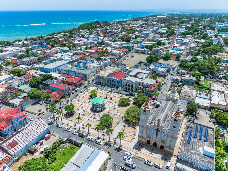
Puerto Plata is the gateway to the Dominican Republic’s north coast, the Amber Coast, where green mountains drop to the Atlantic. The city itself has a character few Caribbean ports can match: a Victorian old town of colorful wooden “gingerbread” houses around a central park, a 16th-century Spanish fortress on the point, a long seafront Malecón, and a cable car that climbs Pico Isabel de Torres for views over the whole coast. Around it lie the resort hotels of Playa Dorada and Costa Dorada, the sheltered bay of Sosúa, the kitesurfing beaches of Cabarete and the 27 Waterfalls of Damajagua, and two of the Caribbean’s busiest cruise ports, Amber Cove and Taíno Bay. The north coast’s weather runs on a different clock from the south: summers are fairly dry, and November to January is the wettest time. Spring and early summer are often the sweet spot.
Right now in Puerto Plata
- Tue 24–31°C 76–87°F 2 mm Showers
- Wed 25–31°C 77–87°F 1 mm Showers
- Thu 25–31°C 76–88°F Partly cloudy
Weather: MET Norway (CC BY 4.0) · Sea temperature: NOAA CoastWatch
Top tours in Puerto Plata
See all tours for Puerto Plata →
From local operators, with prices and reviews; you check availability and book on Viator, our partner. We may earn a commission at no extra cost to you. How we earn money
Puerto Plata at a glance
- Best for: a mix of beach, history and adventure, waterfalls, kitesurfing and windsurfing at Cabarete, diving at Sosúa, and cruise-ship days ashore.
- How long: 4 to 7 days for the city, the beaches and day trips along the coast.
- Best time: spring and early summer (March to July); June to September is the driest stretch, with highs of about 92 °F (33 °C). November to January is the rainiest season, and June to November is hurricane season.
- Getting there: fly to Gregorio Luperón International Airport (POP), between Puerto Plata and Sosúa; cruise ships dock at Amber Cove or Taíno Bay.
- Getting around: taxis, Uber, guaguas along the coast road and organized excursions; a rental car helps for day trips.
- Before you go: fill in the free e-ticket for arrival and departure if you fly, and read our Dominican Republic travel guide for entry rules, money and safety.
Puerto Plata’s areas and who each one suits
The city sits between the mountain and the sea, with resort areas strung along the coast on either side.
The historic center
The old town around Parque Independencia (Central Park), with its white two-story gazebo and the San Felipe Cathedral, has the country’s best collection of Victorian wooden architecture, built in the late 19th and early 20th centuries when the port grew rich on tobacco. Calle de las Sombrillas, with its canopy of colorful umbrellas, and the streets around it have cafés, small museums and shops. Best for culture and a day on foot; the Taíno Bay cruise terminal is close by.
The Malecón and Long Beach
The seafront boulevard runs east from the fortress for a couple of miles, with a promenade, statues, food stalls, bars and the city’s Long Beach. It comes alive in the evenings and on weekends.
Playa Dorada and Costa Dorada
Just east of the city, Playa Dorada is a gated resort complex of all-inclusive hotels on a golden beach, with a golf course; Costa Dorada continues along the shore. Best for an easy beach holiday close to the city and airport.
Cofresí and Costambar
West of the city, these hillside and beachfront communities have villas, apartments, a few resorts and Ocean World marine park and marina. Quieter and good for families and longer stays.
Top things to see in Puerto Plata
Hours and prices change; check with each site before you go, and as of October 2026 prices are often quoted in both pesos and US dollars.
The cable car and Pico Isabel de Torres
The Teleférico, a cable car from the edge of the city, climbs to the top of Pico Isabel de Torres, at about 2,600 feet (793 m). At the summit are a botanical garden with trails, a statue of Christ with open arms in the style of Rio’s, a café and, on clear days, views along the whole coast. Go early, before clouds settle on the mountain, and check that the cable car is running on the day; it can close in bad weather.
Fortaleza San Felipe
Built by the Spanish in the second half of the 16th century to defend the harbor against pirates, the small stone fortress stands on a point at the west end of the Malecón, with cannons, a moat and a small museum. Later used as a prison, it is one of the oldest colonial forts in the Americas, and the lawn around it is a fine spot at sunset.
Victorian Puerto Plata and Central Park
Walk the streets around Central Park to see the gingerbread houses, the art deco San Felipe Cathedral, the Amber Museum, housed in a Victorian mansion, with pieces of Dominican amber holding insects and plants millions of years old, and the umbrella street. The rum distilleries in town offer short visits with tastings.
The 27 Waterfalls of Damajagua
About 30 minutes south-west of the city, near Imbert, the Damajagua River tumbles through a limestone gorge in a series of waterfalls and pools. Local guides lead you upstream on foot and in the water, then you jump, slide and swim back down; most visitors do the first 7 or 12 falls. Helmets and life jackets are provided and compulsory, and the falls may close after heavy rain.
More to see
- Ocean World, Cofresí: a marine park with dolphin and sea lion shows, a beach and a marina; check how animals are kept before you book.
- Sosúa: a sheltered bay with a beach, snorkeling and dive shops, and a small museum on the Jewish refugees who settled here in 1940.
- Cabarete: a laid-back beach town with kitesurfing on Kite Beach and surfing at Encuentro.
- La Isabela National Historic Park: the ruins of Columbus’s 1493 settlement, about an hour west.
Other things to do in Puerto Plata
Kitesurfing, windsurfing and surfing
Cabarete, about 30 minutes east of Puerto Plata, is one of the world’s best-known kitesurfing and windsurfing spots, thanks to steady side-onshore trade winds that are strongest in summer, a reef that breaks the swell and a sandy beach with dozens of schools. Beginners can take a multi-day course. Encuentro beach, just west of Cabarete, has reef breaks for surfers, best in the winter swells from about November to March.
Snorkeling and diving
Sosúa Bay has the north coast’s easiest snorkeling and diving, with reefs and walls a short boat ride from the beach and several dive centers. Day trips to Paradise Island (Cayo Arena), a tiny sand cay surrounded by reef near Punta Rucia, about 1.5 hours west, combine snorkeling with a boat ride through mangroves.
Hiking and nature
Hike the trails at the top of Isabel de Torres, the waterfalls at Damajagua, or head into the mountains to Jarabacoa, about 2 hours inland, for rivers, coffee farms and the start of the trek to Pico Duarte.
Beach safety and sargassum
The north coast faces the open Atlantic, and its beaches can have strong waves and rip currents, especially from November to March when winter swells arrive. Swim at reef-sheltered beaches such as Sosúa or in front of resorts with lifeguards, follow red flags and local advice, and keep clear of kite and surf zones. Sargassum seaweed can reach the north coast, usually between about April and September, though it is generally less of a problem here than on the east coast. According to the University of South Florida’s Sargassum Watch, 2026 has been one of the largest sargassum years on record across the Caribbean, with amounts falling by late September; check local conditions before you go.
Day trips and onward travel
Sosúa and Cabarete
Sosúa is about 25 minutes east, Cabarete about 30 to 40 minutes; both are easy by taxi, Uber or guagua along the coast road. Stay in Cabarete for a few nights if you want to learn to kite.
Santiago and the mountains
Santiago de los Caballeros, the country’s second city, with its Monument to the Heroes of the Restoration and cigar factories, is about an hour inland. Jarabacoa and its rivers are an hour further.
Samaná Peninsula
Las Terrenas and the Samaná Peninsula are about 3 to 4 hours east along the north coast. See our Samaná travel guide.
Santo Domingo
The capital is about 3.5 to 4 hours south by road, via Santiago and the Autopista Duarte; see our Santo Domingo travel guide.
Nearby destinations
- Samaná146 km
- Santo Domingo168 km
- La Romana236 km
- Punta Cana281 km
Getting there and getting around
By air
Gregorio Luperón International Airport (POP), run by Aerodom, lies on the coast between Puerto Plata and Sosúa, about 20 to 30 minutes from the city and 15 to 20 minutes from Sosúa. It has nonstop flights from the US, Canada and Europe, many of them seasonal, and Santiago’s Cibao airport, about 1.5 hours away, has many more flights to the US. From Florida, it is about 2 hours from Miami. Before you fly, every passenger must complete the free e-ticket at eticket.migracion.gob.do, one for arrival and one for departure; the US$10 tourist card and US$20 departure tax are included in airline tickets issued abroad.
Cruise ports: Amber Cove and Taíno Bay
Puerto Plata has two cruise terminals, together among the busiest in the Caribbean:
- Amber Cove: opened in 2015 on Maimón Bay, about 10 miles (16 km) west of the city, by Carnival Corporation. The 25-acre port has a pool, shops, bars and a taxi and rental car stand; excursions to the city, Damajagua and the beaches leave from the pier.
- Taíno Bay: the newer terminal in Puerto Plata’s own harbor, close to the historic center and the Malecón.
According to the Dominican Port Authority, Taíno Bay received about 800,700 visitors from January to August 2026, with about 1.22 million expected for the year, and Amber Cove about 700,600 cruise passengers over the same months. On 15 September 2026 the two terminals together handled four ships with 16,714 passengers. On busy days the old town and the cable car are crowded; visit early or late.
Getting around
Taxis wait at the airport, the cruise ports and the resorts; agree the fare first. Uber works in the city. Guaguas (minibuses) run along the coast road to Sosúa and Cabarete, cheap and frequent but crowded. Caribe Tours and Metro Tours run air-conditioned buses to Santiago and Santo Domingo. A rental car is useful for exploring the coast and mountains, but drive carefully and avoid driving at night.
When to go and how long to stay
Puerto Plata is warm all year, but its rain pattern is the reverse of the south coast’s: winter, when cold fronts and northeast trade winds bring showers, is the rainy season, and summer is drier and hotter. The table uses the 1991–2020 climate normals the Dominican weather service submitted to the World Meteorological Organization for the A. La Unión station at Puerto Plata’s airport.
| Season | Average high / low | Rain per month | What it’s like | Good for |
|---|---|---|---|---|
| Winter (Dec–Feb) | 84–85 °F (29–30 °C) / 66–68 °F (19–20 °C) | 5.2–7.7 in (132–195 mm) | Warm days, cool nights, frequent showers and big surf | Surfing, whale trips to Samaná, Carnival in February |
| Spring (Mar–May) | 85–89 °F (30–32 °C) / 67–71 °F (20–22 °C) | 5.6–6.0 in (143–152 mm) | Warming up, showers easing | Sightseeing, waterfalls, diving |
| Summer (Jun–Aug) | 92 °F (33 °C) / 73 °F (23 °C) | 2.1–3.1 in (54–78 mm) | The driest and hottest months, steady trade winds | Kitesurfing and windsurfing, beach days, family trips |
| Fall (Sep–Nov) | 92 °F falling to 87 °F (33 to 31 °C) / 73 °F falling to 71 °F (23 to 21 °C) | 3.6 in in September rising to 10.1 in in November (91–258 mm) | Hurricane season, then the start of the rains | Quiet, cheaper beaches in September and October |
The station averages about 65 in (1,660 mm) of rain a year, with November the wettest month.
Hurricane season: according to NOAA’s National Hurricane Center (NHC), the Atlantic hurricane season runs from 1 June to 30 November, with most activity from mid-August to mid-October. As of 4 October 2026, the 2026 season had brought eight tropical storms and no hurricanes; around 1 September 2026, according to the Pan American Health Organization’s hazard monitoring, rain and wind linked to the remnants of Tropical Storm Dolly caused partial damage to commercial structures on Puerto Plata’s beaches, with no deaths or injuries reported. Follow the NHC, the Dominican weather service (INDOMET) and the Emergency Operations Center (COE) if you travel in season.
How long to stay: 3, 5 and 7 days
3 days: day one, the old town, Central Park, the Amber Museum and sunset at Fortaleza San Felipe; day two, the cable car in the morning and the beach in the afternoon; day three, the 27 Waterfalls of Damajagua.
5 days: add a day in Sosúa for snorkeling or diving and a day in Cabarete for a kitesurfing or surf lesson.
7 days: add Paradise Island and La Isabela to the west, or a night in the mountains at Jarabacoa.
Where to stay in Puerto Plata and the hotel tax
- Playa Dorada and Costa Dorada: all-inclusive resorts on the beach, close to the city.
- The historic center and Malecón: small hotels and guesthouses, good for culture and nightlife.
- Cofresí and Costambar: villas, apartments and family resorts west of the city.
- Sosúa and Cabarete: beach hotels, apartments and kite camps with a lively, international feel.
As of October 2026, Dominican hotels add the 18% ITBIS (the national value-added tax) and a 10% legal service charge, 28% in all, to rates quoted before tax; packages bought abroad usually include them. Prices on the north coast are generally lower than in Punta Cana.
Practical tips for Puerto Plata
- Cruise days: check which ships are in port and visit the cable car and old town early or late.
- Cable car: go in the morning for the clearest views.
- Damajagua: wear water shoes and swimwear, and leave valuables behind.
- Money: US$1 was about RD$60 in October 2026; pesos get better prices away from the resorts and ports.
- Water: drink bottled water, never tap water.
- Emergencies: call 911; the CESTUR tourist police has officers in Puerto Plata, Sosúa and Cabarete.
What to pack for Puerto Plata
Bring swimwear, a rash vest, reef-safe sunscreen, a hat and sunglasses, plus water shoes with good grip for Damajagua and rocky beaches. Pack a light rain jacket, above all from November to January, a light layer for the breezy summit of Isabel de Torres and cool winter evenings, and insect repellent. Kitesurfers can rent everything in Cabarete, but a well-fitting harness and booties from home help. Visitors from Europe and the UK need a type A/B plug adapter.
Puerto Plata travel FAQ
Which cruise port is in Puerto Plata, Amber Cove or Taíno Bay?
Both. Amber Cove is on Maimón Bay, about 10 miles west of the city, and Taíno Bay is in the city’s own harbor near the old town.
How high is the cable car in Puerto Plata?
The cable car climbs to the top of Pico Isabel de Torres, at about 2,600 feet (793 m), with a botanical garden, a Christ statue and views over the coast. Go early for clear skies.
Are the 27 Waterfalls of Damajagua safe?
They are run with local guides, and helmets and life jackets are compulsory. They can close after heavy rain; go with a licensed guide and follow instructions.
When is the rainy season in Puerto Plata?
Mostly from November to January, the opposite of the south coast. June to August are the driest months, and hurricane season runs from June to November.
How far is Cabarete from Puerto Plata?
About 30 to 40 minutes east by car or guagua along the coast road; Sosúa is on the way.
What is the hotel tax in Puerto Plata?
As of October 2026, 18% ITBIS plus a 10% service charge, 28% in total, when rates are quoted before tax.
Do I need the e-ticket if I arrive on a cruise ship?
According to the official tourism site, cruise passengers don’t need the e-ticket, which is required for everyone on commercial flights, for both arrival and departure.
When is the best time for kitesurfing in Cabarete?
Summer, from about June to August, usually has the most reliable trade winds. Winter is better for surfing at Encuentro.
Is there sargassum in Puerto Plata?
Sometimes, mainly between about April and September, though the north coast is usually less affected than Punta Cana. 2026 has been a heavy year across the Caribbean.
Sources and last review
Researched and last reviewed on 4 October 2026. Amber Cove’s location, opening year and size: Amber Cove; cruise passenger numbers: the Dominican Port Authority; airport operator: Aerodom; e-ticket rules and cruise passengers: the Dominican Presidency and the Ministry of Tourism; tourist card: the tax authority (DGII); departure tax and tap water: the Ministry of Tourism; ITBIS: the DGII; exchange rate: the Central Bank; climate: the WMO 1991–2020 normals for the A. La Unión station; hurricane season: NOAA’s National Hurricane Center; Tropical Storm Dolly: the Pan American Health Organization’s hazard monitoring; sargassum: the University of South Florida’s Sargassum Watch. The cable car height, the history of the fortress and Victorian center, Damajagua rules, Cabarete’s wind season, distances and travel times come from general references and are flagged for checking, as the cable car and Taíno Bay sites could not be read. Prices and timetables change, so check before you go.
Plan your trip
Partner links: TravelerCenter may earn a commission if you book, at no extra cost to you.
🇪🇸 Useful Spanish phrases for Puerto Plata
All 38 Spanish phrases: restaurant, hotel, emergencies, romance (printable) →