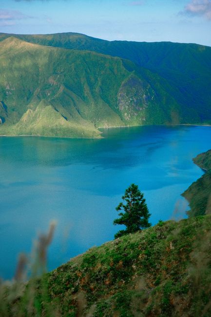
Lagoa do Fogo is a wild crater lake high in the middle of São Miguel, the Azores’ main island, with pale sandy shores, no buildings and steep green walls all around. Seeing it is free: most people stop at the viewpoints on the road over the crater rim, and walkers can reach the shore on the official PRC2SMI trail. In summer the road may close to visitors’ cars, with a €5 shuttle instead (1 August to 30 September in 2026). Go early, before the clouds settle on the rim.
Right now in Lagoa do Fogo
- Thu14–17°C56–62°FPartly cloudy
- Fri14–16°C56–61°F1 mm rain
- Sat13–17°C55–62°FCloudy
Tickets and tours for Lagoa do Fogo
See all tours for Lagoa do Fogo →
From local operators, with prices and reviews; you check availability and book on Viator, our partner. We may earn a commission at no extra cost to you. How we earn money
What it is and why it matters
The lake fills the summit caldera of the Água de Pau volcano (also called Fogo volcano), roughly in the middle of the island between Ribeira Grande on the north coast and Vila Franca do Campo on the south. Its last eruption was in 1563. The lake itself is about 3 km long and 2.5 km wide, and lies at about 575 metres above sea level, the highest of São Miguel’s big lakes, while the crater rim rises to 949 metres at Pico da Barrosa.
There are no houses, roads or cafés inside the crater: it has been protected since 1974 and today is a nature reserve within the São Miguel Natural Park and the Natura 2000 network. That emptiness is the appeal. Where Sete Cidades has a village on its shore, Lagoa do Fogo feels untouched, with native heather, Azores juniper and laurel on the slopes and gulls nesting on the beaches. For the islands as a whole, see our Azores travel guide.
What you’ll see
The viewpoints on the rim
The road between Ribeira Grande and Lagoa crosses the crater rim and passes several viewpoints. The main Miradouro da Lagoa do Fogo looks straight down over the lake and its white beaches; Pico da Barrosa, the highest point of the rim, gives the widest view, and the Bela Vista viewpoint is another stop on the summer shuttle route. Allow 30 minutes to an hour if you only stop at the viewpoints.
The shore
Down by the water there is only sand, reeds and birds. Walk quietly along the beach and give the gulls space, particularly in their nesting season in April and May. Swimming is not a supervised activity here: the lake is not a designated bathing water and there are no lifeguards or facilities.
Walking to the lake
The only certified trail to the shore is PRC2SMI Praia – Lagoa do Fogo, on the official Trails Azores network. It starts by the Parque Escutista dos Lagos, above the village of Praia on the south side, and follows the valley of Ribeira da Praia and its water channels up to the southern shore of the lake, then returns the same way. The official listing gives about 10.2 km and 4 hours, medium difficulty. The levada sections are often wet and muddy, so wear proper shoes.
Many visitors also scramble down from the main roadside viewpoint to the beach. That path is not part of the certified trail network; it is steep and slippery and the climb back up is hard work. If you use it, go only in dry weather and with good shoes.
Nearby, the easy PR circuit “Rota da Água – Janela do Inferno” starts at Casa da Água, at the south end of the shuttle route: 7.6 km and about 2 h 30, through tunnels and aqueducts to a spring-fed rock wall.
The summer shuttle (as of October 2026)
To ease traffic and parking on the rim, the Azores government runs a hop-on, hop-off shuttle in high summer and closes the road to private cars while it operates. In 2026 it ran from 1 August to 30 September, daily from 9:00, between Caldeira Velha on the north side and Casa da Água on the south, with stops at the viewpoints. Tickets cost €5 for non-residents (free for children under 6 and Azores residents). Taxis, licensed tour companies and residents may still drive. Dates have varied from year to year, so check before a summer visit. Outside the shuttle period you can drive up and park at the pull-offs.
When to go
The weather on the rim is the whole story. Clouds often sit on the crater, sometimes all day, while the coast is sunny. Go early in the morning, look at a live webcam or forecast first, and keep a flexible day. Late summer has the most stable weather but also the shuttle and the crowds.
Getting there
The rim road is about half an hour’s drive from Ponta Delgada and its airport. From Ribeira Grande on the north coast it climbs past Caldeira Velha, and from the south it climbs from the town of Lagoa. We found no regular public bus to the viewpoints outside the shuttle period, so without a car take a taxi or a half-day tour.
Safety
- The rim viewpoints are exposed and windy; stay behind barriers with children.
- Fog can close in within minutes. Drive the rim road slowly with lights on.
- The informal path from the viewpoint to the beach is steep and loose; the certified PRC2SMI is the safer way down.
- There is no shop or water inside the crater, and stream water is not safe to drink. Carry what you need and take your rubbish away.
- On marked trails, the numbered posts help rescuers find you: call 112 and give the last number you passed.
Combine it with
On the north side, the warm waterfall pool of Caldeira Velha sits at the start of the shuttle route, and Ribeira Grande has its old town and beaches. To the east, the hot springs and the cozido of Furnas make a full day. On another day, go west to the twin lakes of Sete Cidades.
Lagoa do Fogo FAQ
Is Lagoa do Fogo free to visit?
Yes. The viewpoints, the lake shore and the PRC2SMI trail are free. In the summer shuttle period you pay only the shuttle ticket, €5 for non-residents in 2026.
Can I drive to Lagoa do Fogo?
Outside the shuttle period, yes, and you can park at the viewpoints on the rim. In 2026 the road was closed to visitors’ cars from 1 August to 30 September and a shuttle ran instead.
Can you walk down to the lake?
Yes. The official route is the PRC2SMI trail from near Praia, about 10 km there and back. A steep informal path also drops from the main viewpoint to the beach; it is not a certified trail.
Can you swim in Lagoa do Fogo?
It is not a designated bathing water and has no lifeguards or facilities. It is a nature reserve, so if you do go in, keep away from nesting birds and leave nothing behind.
When is the best time to see Lagoa do Fogo?
Early morning on a clear day, before cloud settles on the rim. Check a webcam or forecast first, and keep a spare day in case the crater is in fog.
Sources
Researched and last reviewed by TravelerCenter on 4 October 2026. Trails come from the official Trails Azores site (Visit Azores); the 2026 shuttle from the operator and regional news; the bathing-water status from Portaria 204-A/2026; the lake’s geography and protection history from standard references. Shuttle dates and road closures change from year to year, so check the official tourism site before a summer visit.
Data: Weather: MET Norway (CC BY 4.0) · Rates: ECB · Costs: World Bank ICP and price levels · Wikidata (CC0)