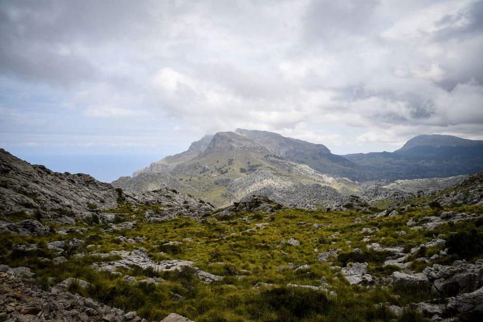
The Serra de Tramuntana is the mountain range along Mallorca’s north-west coast: limestone peaks, terraced olive groves, stone villages and cliffs dropping into the sea. It became a UNESCO World Heritage cultural landscape on 29 June 2011. There is no entrance fee: you explore it by car on the Ma-10, on the 1912 Sóller train, by boat, or on foot along the GR 221 Dry Stone Route, which has 261.1 km of signposted paths and a network of Consell de Mallorca refuges you book online (as of October 2026).
Right now in Serra de Tramuntana
- Wed14–19°C57–66°F31 mm rain
- Thu13–17°C56–63°F3 mm rain
- Fri12–16°C54–60°FCloudy
- Mon 12 Oct National Day of Spain (Fiesta Nacional de España)
Tickets and tours for Serra de Tramuntana
See all tours for Serra de Tramuntana →
From local operators, with prices and reviews; you check availability and book on Viator, our partner. We may earn a commission at no extra cost to you. How we earn money
What it is and why it matters
The Tramuntana runs roughly from Andratx in the south-west to Cap de Formentor in the north-east, and holds Mallorca’s highest peaks, led by Puig Major at about 1,445 metres. UNESCO listed it not for wild nature alone but for what people built here: centuries of farming on steep, dry slopes created terraces held up by dry-stone walls, mule tracks, snow houses and a linked network of channels and cisterns to share scarce water between estates of feudal origin.
The Consell de Mallorca (the island council) looks after the range through a dedicated consortium, maintains the GR 221 and runs free guided heritage walks. For the island as a whole, see our Mallorca travel guide.
What you’ll see
Villages
Valldemossa, with its Carthusian monastery, and Deià, with honey-coloured houses above a pebbly cove, are the prettiest and busiest; arrive early or stay the night. Sóller sits in a valley of orange groves, linked to its horseshoe bay, Port de Sóller, by a vintage tram. Smaller places such as Estellencs, Banyalbufar and Fornalutx are quieter.
Coast and gorges
The road to Sa Calobra drops in tight hairpins to a tiny harbour; a path through rock tunnels leads to the pebbly mouth of the Torrent de Pareis between sheer walls. In the north-east the range ends at Cap de Formentor, with the Es Colomer viewpoint, Formentor beach and a clifftop lighthouse.
Trails
The GR 221 runs from Port d’Andratx to Port de Pollença on restored old paths: 150.1 km of main route plus 111 km of variants, such as the climb to Castell d’Alaró. The main stages pass Sant Elm, Estellencs, Esporles, Deià, Port de Sóller, Tossals Verds, Lluc and Pollença. The highest point is the Coll de ses Cases de sa Neu, at just over 1,200 metres. Popular day walks include the stone staircase of the Barranc de Biniaraix above Sóller and the coastal stretch from Deià to Port de Sóller.
Practical information (as of October 2026)
- Refuges: the Consell runs hikers’ refuges with dormitories and meals on the GR 221: Can Boi, Muleta, Tossals Verds, Son Amer, Pont Romà, Galatzó and Coma d’en Vidal, plus the hostel at Castell d’Alaró. Book online on caminsdepedra.conselldemallorca.cat/refugis, which can check a whole route; the network answers on +34 971 173 700. Example: Galatzó charges €14 per adult a night (€9 up to 16), breakfast €5.50, dinner €9.50. Book weeks ahead in spring and autumn.
- Some GR 221 sections are still unsignposted, such as Cala Tuent and the Gorg Blau, so follow the Consell’s official stage pages.
- Sóller train and tram: the train costs €23 one way or €30 return from Palma, about an hour via Bunyola; the tram to Port de Sóller is €10 each way; a Palma–Port de Sóller–Palma ticket is €40.
- Cap de Formentor: in 2026, from 15 May to 18 October, 10:00 to 22:00, private cars are restricted and the stretch from the beach to the lighthouse is closed to them. Take TIB bus 334 from Alcúdia and Port de Pollença, cycle, or go outside those hours.
- Buses: TIB line 203 links Palma with Valldemossa, Deià, Sóller and Port de Sóller; 204 runs Palma – Port de Sóller.
- Tourist tax: Balearic stays pay the sustainable tourism tax, €1 a night in refuges and hostels in high season.
Getting around
A car gives the most freedom, but the Ma-10 along the range is narrow, winding and shared with cyclists and coaches, and village and trailhead parking is scarce, so arrive before 10:00. Sóller is the best car-free base, with the train, tram, buses and boats. Boats sail from Port de Sóller along the cliffs to Sa Calobra, sea permitting. Road cyclists come in late winter and spring for climbs such as Sa Calobra.
When to go
Spring and autumn are ideal for walking: green slopes, mild days and almond blossom in late January and February. Summer is hot, so hike only at dawn and carry plenty of water. The mountains are cooler and wetter than Palma, October and November are the island’s rainiest months, and winter can bring snow to the high peaks.
Safety
- Heat and water: many paths have little shade and no water; carry at least two litres in warm weather.
- Rain and gorges: the full Torrent de Pareis descent from Escorca is a serious canyon trip with scrambling, for experienced hikers or with a guide, and dangerous after rain. The lower gorge from Sa Calobra is easy.
- Driving: use low gears on the descents and expect cyclists on every bend.
- Tell someone your route, and call 112 in an emergency.
Combine it with
Start in Palma with the Palma Cathedral, ride the train to Sóller, and continue by boat to Sa Calobra if the sea is calm. On the east coast, the Coves del Drach make a good rainy-day alternative. For more mountain walking on islands, compare Madeira‘s levadas. See our hiking, cycling and boat trips guides.
Serra de Tramuntana FAQ
Do you have to pay to visit the Serra de Tramuntana?
No. The range, its viewpoints and trails are free. You pay only for transport, such as the Sóller train (€23 one way), refuges, and sights such as the Valldemossa monastery.
How long is the GR 221?
The main route is 150.1 km from Port d’Andratx to Port de Pollença, and 261.1 km with variants (as of October 2026). Most walkers take about a week for the main stages, sleeping in the Consell’s refuges.
Do I need to book the Tramuntana refuges?
Yes, online on the Consell de Mallorca’s refuge page, especially in spring and autumn. Prices are modest: a dormitory bed at Galatzó costs €14 a night.
Can I visit the Serra de Tramuntana without a car?
Yes. Take the Sóller train or TIB bus 203 or 204 from Palma, then the tram and boats from Port de Sóller. Bus 334 reaches Formentor in summer.
What is the highest mountain in Mallorca?
Puig Major, at about 1,445 metres, in the heart of the Tramuntana. Its summit is a military area, closed to the public.
What is the best time to hike in the Tramuntana?
March to May and late September to November, when it is cool enough to walk all day. In summer, start at dawn.
Sources
Researched and last reviewed by TravelerCenter on 4 October 2026. World Heritage status, the GR 221 and the refuges come from the Consell de Mallorca; the Sóller train and tram from Ferrocarril de Sóller; buses from TIB; Formentor dates from TIB’s line 334 season and regional press; the tourist tax from the Balearic tourism agency. Puig Major’s height and the range’s extent come from standard references. Prices and rules change, so check the official links before you go.
Data: Weather: MET Norway (CC BY 4.0) · Rates: ECB · Holidays: Nager.Date · Costs: World Bank ICP and price levels · © OpenStreetMap contributors (ODBL) · Wikidata (CC0)