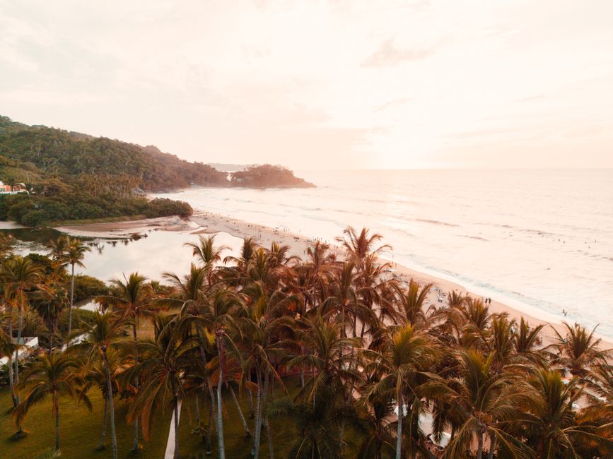
The Riviera Nayarit is the Pacific coast of the state of Nayarit, running north from the Ameca River, the border with Jalisco just north of Puerto Vallarta, to the old port of San Blas. Its southern end, on the Bay of Banderas, has the all-inclusive resorts of Nuevo Vallarta, the seafood town of Bucerías and the upscale peninsula of Punta de Mita; further north come the surf villages of Sayulita and San Pancho, the family beach of Rincón de Guayabitos, and the mangroves, birds and colonial ruins of San Blas. Offshore lie the Marietas Islands and Isla Isabel, both national parks. Humpback whales winter in the bay from about December to March, and the dry season from November to May is the most popular time to visit.
Right now in Riviera Nayarit (San José del Valle)
- Wed24–30°C76–86°F9 mm rain
- Thu24–30°C75–86°F1 mm rain
- Fri25–28°C77–83°F1 mm rain
Top tours in Riviera Nayarit
See all tours for Riviera Nayarit →
From local operators, with prices and reviews; you check availability and book on Viator, our partner. We may earn a commission at no extra cost to you. How we earn money
Riviera Nayarit at a glance
- Best for: all-inclusive and family resorts, surfing and surf lessons, whale watching, boat trips to the Marietas Islands, birdwatching and quiet fishing villages.
- How long: 4–5 days for one base and a boat trip; a week or more to combine the resorts, Sayulita and San Blas.
- Best time: November to May, with highs of 30–34 °C (86–93 °F) and almost no rain; whale season is roughly December to March. July to October is hot, very humid and rainy.
- Getting there: Puerto Vallarta International Airport (PVR), on the Jalisco side of the river, about 10 km (6 miles) from Nuevo Vallarta; or Tepic’s airport for San Blas.
- Getting around: local buses along Highway 200, taxis, and a rental car to explore the coast.
- Before you go: entry rules, money and general safety are in our Mexico travel guide; for the city across the river, see our Puerto Vallarta guide.
The Riviera Nayarit’s areas: where things are
The coast stretches for roughly 300 km (190 miles). Highway 200 follows it from Nuevo Vallarta north through Sayulita to Rincón de Guayabitos and Las Varas, where the road to San Blas branches off along the coast. One practical detail: the municipality of Bahía de Banderas, which covers the southern part from Nuevo Vallarta to Punta de Mita, Sayulita, San Pancho and Lo de Marcos, keeps Central time (UTC−6) like Puerto Vallarta, while the rest of Nayarit, including Guayabitos and San Blas, uses Pacific time (UTC−7), one hour behind. Check the time zone of your hotel, tours and flights.
Nuevo Vallarta and Flamingos
A planned resort area on a long, flat beach just across the river from Puerto Vallarta, with large all-inclusive hotels, a marina, golf courses and the quickest transfer from the airport. The sea is gentle here, and it is popular with families.
Bucerías and La Cruz de Huanacaxtle
Bucerías is a relaxed town with a long beach, cobbled streets, galleries and beach restaurants; neighboring La Cruz de Huanacaxtle has a marina, a Sunday market and a fish market. Both are good for independent travelers who want a real town with the resorts close by.
Punta de Mita
The peninsula at the northern tip of the bay has luxury resorts, private villas and golf courses, plus the fishing village of El Anclote, where boats leave for the Marietas Islands and surfers paddle out to long, gentle waves.
Sayulita and San Pancho
Sayulita, about 40 km (25 miles) north of the airport, is a colorful village with a beginner-friendly surf break, surf schools, cafés, boutiques and a lively evening plaza; it can be very busy in high season. San Pancho (San Francisco), a few minutes north, is quieter, with a wide beach and a community arts scene. Lo de Marcos and San Ignacio, further on, are smaller and calmer.
Rincón de Guayabitos and the central coast
Around Jaltemba Bay, Rincón de Guayabitos and La Peñita are classic Mexican family beach towns with calm water, bungalows and boat rides to Isla del Coral. Chacala, a little further north, is a small fishing village in a palm-fringed cove.
San Blas
At the northern end, San Blas was the Spanish Crown’s main Pacific naval base in the late 18th century. Today it is a sleepy fishing town known for its mangrove river tours, birdwatching, surf in winter and the ruins of the old fort on the Cerro de San Basilio. The nearby lagoons are famous for their sand flies (jejenes) at dusk.
Top things to see in the Riviera Nayarit
Prices and hours below were checked on the official sites in October 2026, unless we say otherwise; check again before you go.
The Marietas Islands
Two uninhabited volcanic islands off Punta de Mita form a national park and a UNESCO biosphere reserve, with blue-footed boobies and other seabirds, coral, tropical fish and, in winter, passing humpback whales. Their most famous spot is the Playa del Amor (Hidden Beach), a beach inside a collapsed crater, reached by swimming through a short tunnel from the sea in small, guided groups. According to the National Commission of Natural Protected Areas (CONANP), the park opens Tuesday to Sunday, 8 a.m. to 6 p.m., and the Playa del Amor site Wednesday to Sunday, 8 a.m. to 5 p.m.; the park fee is MXN 125 (about US$7) per person per day, usually included by tour operators, with exemptions for seniors, people with disabilities and children under 12. Visits to the hidden beach are limited and must be booked with an authorized operator; landing on the other beaches is not allowed. See our boat trips guide.
Whale watching in the Bay of Banderas
Humpback whales come to the bay to mate and give birth, roughly from December to March. Tours leave from Nuevo Vallarta, La Cruz de Huanacaxtle and Punta de Mita; choose a licensed operator that keeps the legal distances, and expect to see dolphins and seabirds too.
Sayulita’s beach and surf
Sayulita’s main break is gentle and good for learning, with surf schools and board rentals along the beach; there are also stronger waves at the point and at nearby beaches. See our surfing guide. Respect the flags, and remember that currents can be strong when the swell is up.
Isla Isabel National Park
A small volcanic island about 70 km (43 miles) off San Blas, nicknamed the Mexican Galápagos for its nesting frigatebirds and boobies, which allow people to come close. According to CONANP, it can only be reached by sea, with authorized boat operators from San Blas or from Boca de Camichín, about 30 km (19 miles) away; the fee is MXN 125 per person per day, and trips depend on the weather, especially in hurricane season.
San Blas mangroves and La Tovara
Boats glide through tunnels of mangroves from San Blas to La Tovara, a spring-fed freshwater pool where you can swim, passing herons, turtles and crocodiles. Tours leave from the El Conchal pier and the village of Matanchén; go in the morning, and bring repellent.
More to see
- Punta de Mita’s beaches: El Anclote and Playa Destiladeras have calm water and seafood restaurants; Destiladeras is good for families.
- Monkey Mountain (Cerro del Mono): a steep hike above Higuera Blanca with views over the bay; go with a local guide and start early.
- Altavista petroglyphs: ancient rock carvings along a jungle stream near Las Varas, a sacred site for the Wixárika (Huichol) people.
- Chacala: a calm, palm-fringed cove with fishing boats and simple beach restaurants.
Nature
- La Tovara
- Marietas Islands
Nature reserves
- Isla Isabel National Park
Activities and best months
- Boat tripsCONANP: Islas Marietas National Park off Punta de Mita opens Tuesday to Sunday (Playa del Amor Wednesday to Sunday), MXN 125 per person per day; Isla Isabel is reached only by sea with authorised operators from San Blas (70 km) or Boca de Camichín.
Other things to do in the Riviera Nayarit
Beaches and water sports
The beaches facing the bay, from Nuevo Vallarta to Punta de Mita, are mostly calm, while the coast north of Punta de Mita faces the open Pacific, with more waves. Paddleboarding, snorkeling, sport fishing and sailing are all easy to arrange. Sea turtles nest on many beaches from about June to November, and several community camps run hatchling releases. See our beaches guide.
Golf, food and crafts
The resort areas have several championship golf courses. Eat pescado zarandeado, a whole butterflied fish grilled over wood, a Nayarit specialty, along with fresh oysters and shrimp aguachile. Look for beadwork and yarn paintings by Wixárika (Huichol) artisans, who sell in Sayulita, Bucerías and San Blas.
Day trips from the Riviera Nayarit
- Puerto Vallarta: across the river, with the Malecón, the old town and the Zona Romántica, about 20–40 minutes from Nuevo Vallarta. See our Puerto Vallarta guide.
- Marietas Islands: a half-day boat trip from Punta de Mita or Nuevo Vallarta.
- San Blas and Isla Isabel: about three hours north of Nuevo Vallarta by car; stay a night for the mangroves and an early boat to Isla Isabel.
- Tepic and Mexcaltitán: Nayarit’s capital lies inland, and the island village of Mexcaltitán, built on a lagoon, is a long day’s drive north.
- Guadalajara and Tequila: about four to five hours inland by toll road; see our Guadalajara guide.
Nearby destinations
- Puerto Vallarta17 km
- Tequila156 km
- Guadalajara207 km
- Mazatlán295 km
Getting there and getting around
By air
Most visitors fly into Puerto Vallarta International Airport (PVR), run by the airport group GAP, about 10 km (6 miles) from Nuevo Vallarta; it has direct flights from many cities in the United States, Canada and Mexico. From the airport it is about 15–20 minutes to Nuevo Vallarta, 45–60 minutes to Sayulita, and about an hour and a half to Guayabitos. Tepic’s airport (TPQ), with domestic flights, is closer to San Blas.
By road
Highway 200 runs up the coast from Puerto Vallarta; a toll road links Puerto Vallarta with the Jala–Compostela area and Tepic and on to Guadalajara. First-class buses run between Puerto Vallarta, Tepic and Guadalajara.
Getting around the Riviera Nayarit
Local buses run frequently along Highway 200 between Puerto Vallarta, Nuevo Vallarta, Bucerías, Punta de Mita and Sayulita, for a small cash fare. Taxis do not have meters, so agree on the fare first. A rental car is the easiest way to explore the northern coast and San Blas; don’t drive at night outside towns, and remember the time change at the municipal border.
When to go and how long to stay
The Riviera Nayarit is warm all year. The table uses the National Meteorological Service’s (SMN-Conagua) 1991–2020 climate normals for the San José del Valle station, in Bahía de Banderas near Nuevo Vallarta: average daily highs and lows, and days with rain.
| Season | Average high / low | Rainy days per month | What it’s like | Good for |
|---|---|---|---|---|
| Winter (Dec–Feb) | 30–31 °C (86–87 °F) / 16–17 °C (61–63 °F) | 1 | Dry and sunny, with cool mornings | Whale watching, Marietas trips, surf on the northern breaks |
| Spring (Mar–May) | 31–34 °C (88–92 °F) / 16–20 °C (61–68 °F) | 0 | Dry, sunny and getting hotter; busy at Easter | Beaches, boat trips, golf |
| Summer (Jun–Aug) | 35 °C (94 °F) / 23–24 °C (74 °F) | 6–14 | Hot and very humid, with heavy storms; warmest sea | Turtle season, lower prices |
| Fall (Sep–Nov) | 33–34 °C (91–94 °F) / 20–24 °C (68–74 °F) | 14 in September, 2 in November | Wet and humid until October, then dry | Quiet beaches from November |
The station records about 1,100 mm (43 in) of rain a year, almost all of it from June to October; August is the wettest month, with about 297 mm (12 in).
Hurricane season: according to NOAA’s National Hurricane Center, the eastern Pacific hurricane season runs from May 15 to November 30. If a storm threatens, follow the instructions of Nayarit’s civil protection authorities and your hotel, and check Mexico’s National Meteorological Service (SMN) and the National Hurricane Center; boat trips to the islands are suspended in rough weather.
4 days in the Riviera Nayarit
Day one, settle in at Nuevo Vallarta or Bucerías and walk the beach at sunset. Day two, a morning boat trip to the Marietas Islands, or whale watching in winter. Day three, Sayulita for a surf lesson and the plaza. Day four, Punta de Mita’s beaches and lunch at El Anclote.
6 to 8 days in the Riviera Nayarit
Add San Pancho, Lo de Marcos and Chacala on the way north, a night or two in San Blas for the mangroves and Isla Isabel, and an evening in Puerto Vallarta’s old town.
Where to stay in the Riviera Nayarit and the hotel taxes
- Nuevo Vallarta: large all-inclusive resorts on a calm beach, closest to the airport; best for families and easy holidays.
- Bucerías and La Cruz: small hotels and rentals in real towns, with restaurants in walking distance.
- Punta de Mita: luxury resorts and villas; the most expensive part of the coast.
- Sayulita and San Pancho: boutique hotels, guesthouses and vacation rentals; lively in Sayulita, quieter in San Pancho.
- Guayabitos and San Blas: simple hotels and bungalows at the lowest prices.
Room rates are often quoted before tax. Nayarit’s state lodging tax is 5% for 2026, under the state’s 2026 revenue law, including stays booked through digital platforms, and federal VAT (IVA) of 16% is added on top. All-inclusive prices usually include taxes, but check. VISITAX does not apply here; it is a Quintana Roo fee only.
Practical tips for the Riviera Nayarit
- Time zones: Bahía de Banderas (Nuevo Vallarta to Lo de Marcos) uses Central time; Guayabitos, San Blas and the rest of Nayarit use Pacific time, one hour behind.
- Cash: carry pesos for buses, taxis, beach restaurants and boat tours in small villages; ATMs are in the larger towns.
- Boat trips: book the Marietas Islands with authorized operators, and bring the park fee if it is not included.
- Tipping: 10–15% in restaurants; tip boat crews and surf instructors.
- Safety: the resort areas and beach towns are busy with visitors and generally calm. Use app, hotel or authorized taxis at night, drive by day, keep valuables out of sight on the beach, don’t buy drugs, and respect the beach flags, as rip currents are strong on the open-ocean beaches.
- Emergencies: call 911.
What to pack for the Riviera Nayarit
Bring light beachwear, a hat, sunglasses and biodegradable, reef-friendly sunscreen, a rash guard for surfing and snorkeling, water shoes and a dry bag for boat trips. Insect repellent is essential, especially in San Blas at dusk; add a light sweater for winter mornings on the water and a rain jacket from June to October. Plugs are the US type.
What to pack
- Dry bags and phone pouchesSpray soaks phones and cameras on open boats to the Algarve caves and on whale-watching trips.
- Fleeces and warm layersIt is cooler at sea than on land, especially on morning whale-watching trips.
- Rain jacketsA windproof, waterproof shell keeps you warm on open boats, where wind and spray cool you quickly.
- Reef-friendly sunscreenSun reflects off the water on cruises and cave tours.
- Water shoesKayak and small-boat trips to the Algarve grottoes land on rock and wet sand.
Riviera Nayarit travel FAQ
Where is the Riviera Nayarit?
On Mexico’s Pacific coast in the state of Nayarit, running north from Nuevo Vallarta, just across the river from Puerto Vallarta, for about 300 km (190 miles) to San Blas.
What is the closest airport to Sayulita and Nuevo Vallarta?
Puerto Vallarta International Airport (PVR), about 15–20 minutes from Nuevo Vallarta and 45–60 minutes from Sayulita by road.
Is the Riviera Nayarit in a different time zone from Puerto Vallarta?
The southern part, Bahía de Banderas (Nuevo Vallarta to Sayulita and Lo de Marcos), has the same Central time as Puerto Vallarta. The rest of Nayarit, including Guayabitos and San Blas, is one hour behind.
How much does it cost to visit the Marietas Islands?
CONANP’s park fee is MXN 125 (about US$7) per person per day, usually included in the tour price; the boat trip itself costs extra. The park opens Tuesday to Sunday.
Can you visit the Playa del Amor (Hidden Beach)?
Yes, on guided, limited visits with authorized operators, Wednesday to Sunday from 8 a.m. to 5 p.m., according to CONANP. You swim in through a short tunnel, so you must be a confident swimmer.
When is whale season in the Riviera Nayarit?
Humpback whales visit the Bay of Banderas roughly from December to March. Tours leave from Nuevo Vallarta, La Cruz de Huanacaxtle and Punta de Mita.
Is Sayulita good for beginner surfers?
Yes. Its main break is gentle, and surf schools on the beach rent boards and give lessons. More experienced surfers head to Punta de Mita and the breaks further north.
What taxes are added to hotel bills in Nayarit?
Nayarit’s 5% lodging tax for 2026 plus 16% IVA. There is no VISITAX here.
What is the best time to visit the Riviera Nayarit?
November to May, when it is dry and sunny; December to March adds whale watching. Summer is hot, humid and rainy, but quieter and cheaper.
How do I get to San Blas?
By car, about three hours north of Nuevo Vallarta via Highway 200 and the coast road from Las Varas, or about an hour from Tepic, which has an airport and bus connections.
Plan your trip
Partner links: TravelerCenter may earn a commission if you book, at no extra cost to you.
🇪🇸 Useful Spanish phrases for Riviera Nayarit
All 38 Spanish phrases: restaurant, hotel, emergencies, romance (printable) →
Sources · last reviewed 4 October 2026
Researched and last reviewed on 4 October 2026. Marietas Islands and Isla Isabel hours, fees and access: the National Commission of Natural Protected Areas (CONANP); the lodging tax: the State of Nayarit’s 2026 revenue law, published in the state’s official gazette on December 29, 2025; hurricane season: NOAA’s National Hurricane Center; climate: SMN-Conagua 1991–2020 normals for the San José del Valle station. The time-zone split follows Mexico’s time zones law as summarized on our Mexico page. Distances, travel times, whale and turtle seasons, surf conditions, the Playa del Amor visitor limits and local sights come from secondary sources or general knowledge and are flagged for checking. Prices and timetables change, so check the official sites before you go. For entry rules, money and general safety, see our Mexico travel guide.
Also: descubreanp.conanp.gob.mx
Data: Weather: MET Norway (CC BY 4.0) · Sea temperature: NOAA CoastWatch · Rates: ECB · Costs: World Bank ICP and price levels · © OpenStreetMap contributors (ODBL) · Wikidata (CC0)