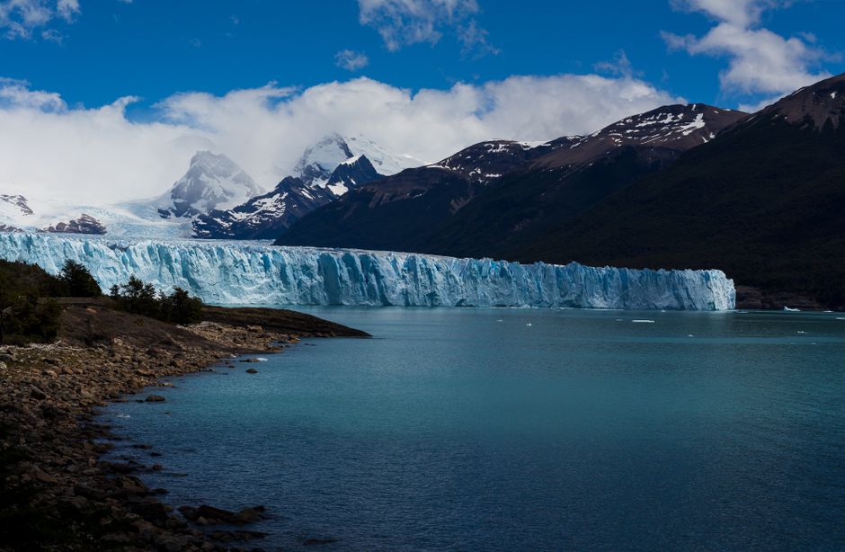
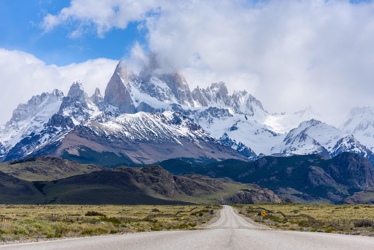
Los Glaciares National Park, in Santa Cruz province in southern Argentine Patagonia, protects a vast stretch of the Andes where the Southern Patagonian Ice Field, the largest ice cap outside Antarctica and Greenland, spills dozens of glaciers into milky-turquoise lakes. Its star is the Perito Moreno Glacier, a wall of blue ice about 5 km (3 miles) wide that ends in Lago Argentino, where house-sized blocks crack and crash into the water in front of the viewing walkways. In the park’s north zone, the village of El Chaltén sits at the foot of the granite spires of Mount Fitz Roy and Cerro Torre, with some of the finest day hikes in South America. Created in 1937 and a UNESCO World Heritage Site since 1981, the park is visited from two bases, El Calafate for the glaciers and El Chaltén for trekking, about 200 km (125 miles) apart. Visit from October to April, when days are long and boats and treks run.
Right now in Los Glaciares National Park (El Calafate)
- Tue 3–8°C 37–46°F Mostly clear
- Wed 4–8°C 39–47°F Mostly clear
- Thu 6–9°C 42–48°F Clear
- Mon 12 Oct Day of Respect for Cultural Diversity (Día del Respeto a la Diversidad Cultural)
Weather: MET Norway (CC BY 4.0) · Holidays: Nager.Date
Top tours in Los Glaciares National Park
See all tours for Los Glaciares National Park →
From local operators, with prices and reviews; you check availability and book on Viator, our partner. We may earn a commission at no extra cost to you. How we earn money
Los Glaciares at a glance
- Best months: November to March for long days and all services; October and April are quieter, colder and windier, with fall colors in April.
- Time needed: two days in El Calafate for the Perito Moreno Glacier and a boat trip; at least three days in El Chaltén for the main hikes, plus a spare day for bad weather.
- Fee (as of October 2026): ARS 50,000 (about US$33) per day for foreign visitors, in both the south (glacier) and north (El Chaltén) zones; 50% off a second day within 72 hours.
- Getting there: fly to El Calafate (FTE), about 3 hours 15 minutes from Buenos Aires; El Chaltén is about 3 hours by bus from El Calafate.
- Before you go: entry rules, money and general safety are in our Argentina travel guide.
Fees, tickets and rules (as of October 2026)
The park is run by Argentina’s National Parks Administration (APN). According to its fee table in force since June 1, 2026, and the park’s official page:
| Ticket | Price | How to pay |
|---|---|---|
| South zone: Río Mitre portal (Perito Moreno Glacier) and Puerto Punta Bandera | Foreign visitors ARS 50,000 (about US$33) per day | In person by Visa or Mastercard credit card, debit card or cash in pesos, or online |
| North zone: El Chaltén trail portals (Los Cóndores, Cerro Torre, Base Fitz Roy, Río Eléctrico) | Foreign visitors ARS 50,000 (about US$33) per day | Online only, on the web or by scanning the QR code at the portal; credit or debit card only, no cash |
| Second day in the same park within 72 hours | 50% off | Online, or at the gate with your first ticket |
| Flexipass 3 days / 7 days (general) | ARS 100,000 / ARS 175,000 | Useful for several days of hiking in El Chaltén |
| Residents of Argentina | ARS 25,000 | Argentine ID required |
| Children up to 6, visitors with a disability certificate and one companion | Free | Show documents |
- Trail registration: according to the park, registration at the park information center (or online) is compulsory for climbing and trekking in remote areas, and for all trails from May to September.
- Rules: stay on marked trails, carry out all trash, don’t light fires, and camp only in designated sites. Drones need a permit.
- Exchange: on October 2, 2026, the Central Bank’s reference rate was about ARS 1,520 per US dollar; foreign cards are settled at the financial (“MEP”) dollar rate.
The Perito Moreno Glacier
The walkways
The glacier area is about 50 km (31 miles) from El Calafate to the Río Mitre portal on paved Provincial Route 11, and the walkways are about 30 km beyond. According to the park, more than 4.5 km (2.8 miles) of walkways with viewpoints run through the forest down to the glacier front, with steps between levels and accessible options for people with reduced mobility; the longest single route is about 1.1 km. Spend at least three to four hours: the glacier calves unpredictably, with loud cracks and splashes all day. Every few years, the glacier advances across the channel to the Magallanes Peninsula, damming the Brazo Rico arm of the lake until the water bursts through the ice in a “rupture,” a famous spectacle that can’t be predicted far ahead.
Boat trips at the glacier
From the walkway area and the nearby port, licensed boats sail to the glacier’s south face and north face (one-hour trips such as the “Safari Náutico” and “Moreno Spirit”), and some combine the boat with the walkways. See our guide to boat trips.
Walking on the ice
Licensed operators lead guided treks on the glacier with crampons, from shorter “mini” treks to longer full-day walks for fit hikers; they cross the lake by boat and include a walk through the moraine. Age and fitness limits apply. Kayak trips in front of the glacier, of about two hours, need no experience, according to the park.
Puerto Bandera: Upsala and Spegazzini glaciers
From Puerto Punta Bandera, 47 km (29 miles) from El Calafate on paved roads, full-day boat trips sail the North Arm of Lago Argentino through iceberg-filled channels to the Upsala Glacier, the park’s largest, and the Spegazzini Glacier, its tallest, with stops at Spegazzini refuge or Estancia Cristina. The park entry fee applies, and trips are booked in El Calafate, with transfers available.
El Chaltén: Fitz Roy and Cerro Torre
El Chaltén, founded in 1985 and known as Argentina’s trekking capital, is the base for the park’s north zone; many trails start right from the village. The main day hikes, according to the park:
- Laguna de los Tres (Fitz Roy): the most popular hike, to the lake at the foot of Mount Fitz Roy, about 25 km (15.5 miles) round trip and 8–9 hours, medium-to-hard difficulty, with a steep last hour. Start before dawn for sunrise on the peaks, or at least early to beat the wind.
- Laguna Torre (Cerro Torre): about 18 km (11 miles) round trip along the Fitz Roy River valley to the lake below Cerro Torre, 3–4 hours each way.
- Laguna Capri: a shorter option on the Fitz Roy trail, with views of the massif from a lake with a campsite.
- Mirador de los Cóndores and Mirador de las Águilas: short climbs right from the village, good for arrival day and sunset.
- Chorrillo del Salto: an easy walk or drive to a waterfall about 6 km (4 miles) from the village.
North of El Chaltén, the Lago del Desierto provincial reserve, 37 km (23 miles) away by gravel road, has forest trails and boat trips toward the Chilean border. El Chaltén is also a world center for technical climbing on Fitz Roy and Cerro Torre; expeditions and ice-field crossings must be registered with the park. See our guide to hiking.
Getting there
- By air: El Calafate’s Comandante Armando Tola International Airport (FTE), about 20 km (12 miles) east of town, has flights from Buenos Aires (about 3 hours 15 minutes), Ushuaia, Bariloche and other cities; shuttle buses and taxis run to town.
- To the glacier: by car, by regular buses from El Calafate’s bus terminal, by remis or on an organized tour.
- To El Chaltén: buses run several times a day from El Calafate, about 3 hours on paved roads including part of the famous Route 40; some run straight from the airport in high season.
- From Chile: buses link El Calafate with Puerto Natales, gateway to Torres del Paine, in about 5–6 hours including the border crossing; bring your passport.
Getting around: practical details
From El Calafate’s bus terminal, regular buses run to the Perito Moreno walkways in the morning and return in the afternoon; buy a round trip and check the return time, as the park fee is paid separately at the Río Mitre portal. Tour agencies sell glacier trips with transport, boat trips, and ice treks that include pickup. For El Chaltén, several bus companies run daily, more often in summer; book a day or two ahead in January and February. In El Chaltén itself, everything is walkable, and the main trailheads start at the edge of the village; minibuses run to El Pilar and Lago del Desierto for one-way hikes back to town. Renting a car in El Calafate is useful for Lago Roca, estancias and the drive to El Chaltén, but fuel stations are few: fill up at El Calafate, La Leona or El Chaltén.
Around Los Glaciares
- El Calafate: the town on Lago Argentino has the Glaciarium ice museum and interpretation center, the Laguna Nimez bird reserve with flamingos, and estancias offering lamb barbecues and sheep-shearing shows.
- Lago Roca: a quieter southern sector of the park, about 50 km from El Calafate on gravel roads, with a campsite, cave paintings and the steep climb of Cerro de los Cristales; the short rock-art trail is free.
- The central zone: remote lakes reached by long gravel roads, open only in spring and summer, with no communications; tell the rangers when you go in and come out.
- Torres del Paine (Chile): a long day trip or, better, a separate stay from Puerto Natales.
More trips from El Calafate and El Chaltén
- Estancia visits: sheep ranches near El Calafate, such as those on the road to the glacier and on Lago Argentino, offer lamb barbecues, horseback rides and sheep-shearing demonstrations.
- Walichu caves: rock paintings on the shore of Lago Argentino near El Calafate.
- Glacier Huemul and Lago del Desierto: a short hike to a hanging glacier at the northern end of the road from El Chaltén, outside the national park.
- La Leona roadhouse: a historic stop on Route 40, halfway between the two towns, famous for pies and its outlaw history.
Nearby destinations
When to go and how long to stay
The park lies in the rain shadow of the Andes: the ice field to the west is one of the wettest places on Earth, but El Calafate on the steppe is dry, sunny and windy. The table uses the National Meteorological Service’s 1991–2020 normals for the El Calafate airport station, as published by the World Meteorological Organization; El Chaltén, closer to the mountains, is wetter and cooler.
| Season | Average high / low | Rainy days per month | What it’s like |
|---|---|---|---|
| Summer (Dec–Feb) | 18–19 °C (64–67 °F) / 6–7 °C (43–45 °F) | 1–2 | Long days (up to about 17 hours of daylight), strong winds, busiest season |
| Fall (Mar–May) | 17 °C falling to 9 °C (62 to 48 °F) / 5 °C falling to −2 °C (40 to 29 °F) | 3–4 | Red and gold beech forests in April, calmer winds, fewer people |
| Winter (Jun–Aug) | 5–7 °C (41–44 °F) / −4 to −3 °C (24–27 °F) | 3–4 | Cold and short days; the glacier is open, but many El Chaltén businesses close |
| Spring (Sep–Nov) | 11 °C rising to 16 °C (52 to 60 °F) / −1 °C rising to 4 °C (31 to 39 °F) | 1–2 | Windy and bright; services reopen from October |
The El Calafate station records only about 160 mm (6 in) of precipitation a year, but the wind is the defining feature: strong westerlies, often gusting above 60 km/h (37 mph), blow especially from spring to late summer, and boat trips and high trails can be canceled. Weather in the mountains changes in minutes, so plan spare days.
Los Glaciares month by month
Average daily highs and lows at the El Calafate airport station (SMN 1991–2020 normals, via the WMO); El Chaltén is wetter and cooler.
| Month | High / low | What to expect |
|---|---|---|
| January | 19 °C (66 °F) / 7 °C (45 °F) | Peak season, longest days, strong winds |
| February | 19 °C (67 °F) / 7 °C (44 °F) | Busy and windy; best trekking weather |
| March | 17 °C (62 °F) / 5 °C (40 °F) | Calmer winds, fewer crowds |
| April | 13 °C (55 °F) / 1 °C (34 °F) | Fall colors in the beech forests; some services close at the end of the month |
| May | 9 °C (48 °F) / −2 °C (29 °F) | Low season; El Chaltén quiet |
| June | 6 °C (42 °F) / −4 °C (25 °F) | Winter; the glacier walkways stay open |
| July | 5 °C (41 °F) / −4 °C (24 °F) | Coldest month; snow on trails, registration required |
| August | 7 °C (44 °F) / −3 °C (27 °F) | Cold, short days |
| September | 11 °C (52 °F) / −1 °C (31 °F) | Spring arrives; winds pick up |
| October | 14 °C (56 °F) / 1 °C (34 °F) | Services reopen; quieter than summer |
| November | 16 °C (60 °F) / 4 °C (39 °F) | Long days, wildflowers, good value |
| December | 18 °C (64 °F) / 6 °C (43 °F) | Summer starts; busy from Christmas |
Crowds: January and February are the peak, with full buses, busy trails and high prices; book flights, hotels and glacier treks well ahead. Easter and long weekends are also busy.
Three days
Day one, fly into El Calafate and visit the Laguna Nimez reserve or the Glaciarium. Day two, the Perito Moreno Glacier walkways with a boat trip or an ice trek. Day three, the Puerto Bandera boat trip to the Upsala and Spegazzini glaciers.
A week
Add three or four days in El Chaltén for Laguna de los Tres, Laguna Torre, the Mirador de los Cóndores and Lago del Desierto, keeping a day spare for weather, or add a side trip to Torres del Paine in Chile.
Where to stay
- El Calafate: the main base for the glacier, with hotels, hostels and estancias, restaurants and tour agencies; lake-view hotels sit on the hill above town.
- El Chaltén: hostels, guesthouses and small hotels in the village, with trailheads on the doorstep; many close from about May to September.
- Inside the park: a few lodges and estancias, and campsites at Lago Roca and on El Chaltén’s trails (some free, some run by concessions).
Foreign tourists who pay for accommodation with a card issued abroad don’t pay Argentina’s 21% VAT (IVA) on the room; give the hotel your passport details.
Choosing where to stay
In El Calafate, the center along Avenida Libertador is convenient for restaurants, agencies and buses; hotels on the hill above town have lake views and offer shuttles; and estancias outside town give a ranch experience. In El Chaltén, choose a place close to the trailhead you plan to start most hikes from; the village is small, but the north end is nearest the Fitz Roy trail. Campers can use the free backcountry sites at Laguna Capri and De Agostini, and paid campsites in the village.
Food and drink
Patagonian lamb roasted on a cross (cordero al asador) is the signature dish in both towns, along with trout, king crab brought from the south, and stews in winter. Calafate berries, which give El Calafate its name, flavor jams, ice cream and liqueurs; local legend says that whoever eats them will return to Patagonia. El Chaltén has a lively craft beer scene and many cafés serving hikers big breakfasts and packed lunches; buy trail snacks the day before, as shops open late. Prices are higher than in northern Argentina, because most food comes from far away.
What a trip to Los Glaciares costs
These are our estimates for October 2026 at about ARS 1,520 per US dollar, except the park fee, which is official.
| Item | Typical price |
|---|---|
| Park entry, foreign visitor, per day | ARS 50,000 (US$33), official |
| Bus El Calafate–Perito Moreno, round trip | ARS 40,000–60,000 (US$26–39) |
| One-hour glacier boat trip | ARS 50,000–80,000 (US$33–53) |
| Short guided ice trek | ARS 250,000–400,000 (US$165–265) |
| Bus El Calafate–El Chaltén, one way | ARS 30,000–50,000 (US$20–33) |
| Hostel bed | ARS 25,000–45,000 (US$16–30) |
| Mid-range double room | ARS 130,000–250,000 (US$85–165) |
| Lamb dinner with wine | ARS 40,000–70,000 (US$26–46) |
Practical tips for Los Glaciares
- Buy El Chaltén tickets online: the north zone’s trail portals take no cash; buy your day ticket on the official site before you start, or scan the QR code at the portal where there is signal.
- Money: El Chaltén has few ATMs, which often run out of cash; cards are widely accepted, but carry some pesos.
- Wind and sun: windproof layers, sunglasses and strong sunscreen are essential; the ozone layer is thin at this latitude in spring.
- Water: stream water on El Chaltén’s trails is generally drinkable, according to local practice, but don’t wash or relieve yourself near streams.
- Safety: stay behind the railings at the Perito Moreno walkways: falling ice causes waves and flying fragments near the shore. On trails, register as required, start early, turn back if the wind becomes dangerous on exposed sections, and never cross glaciers without a licensed guide. There is little phone coverage outside the towns. For emergencies, call 911.
What to pack for Los Glaciares
A windproof and waterproof jacket, warm fleece or down layers, a hat and gloves (even in summer), broken-in hiking boots, trekking poles for the steep descents, sunglasses, high-factor sunscreen and lip balm, a daypack, a refillable bottle and snacks. Argentina uses 220 V and type I plugs.
Los Glaciares travel FAQ
How much does it cost to see the Perito Moreno Glacier?
As of October 2026, foreign visitors pay ARS 50,000 (about US$33) per day to enter Los Glaciares National Park, which covers the glacier walkways. Boat trips and ice treks are extra.
Do I need to pay to hike in El Chaltén?
Yes. Since June 2026, foreign visitors pay ARS 50,000 (about US$33) per day at the north zone’s trail portals, online only and by card.
How far is the Perito Moreno Glacier from El Calafate?
The park’s Río Mitre portal is about 50 km (31 miles) from El Calafate on paved Route 11, and the walkways are further on; allow about 1.5 hours each way.
How long is the Fitz Roy hike?
The hike to Laguna de los Tres is about 25 km (15.5 miles) round trip and takes 8–9 hours, with a steep final climb, according to the park.
When is the best time to visit Los Glaciares?
November to March, for long days and all services. Expect strong winds, especially in spring and summer, and plan spare days.
Can I walk on the Perito Moreno Glacier?
Yes, on guided treks with crampons run by licensed operators, from short “mini” treks to full days. Book ahead in summer.
How do I get from El Calafate to El Chaltén?
By bus, about 3 hours on paved roads, with several departures a day; the towns are about 200 km (125 miles) apart.
Where should I stay for the Perito Moreno Glacier?
In El Calafate, about 1.5 hours away by road; there is little lodging near the glacier itself.
What is the weather like in El Calafate in summer?
Average highs of about 18–19 °C (64–67 °F), cool nights, long days and strong winds.
What should I eat in El Calafate and El Chaltén?
Patagonian lamb, trout and anything made with calafate berries, plus craft beer in El Chaltén.
Sources and last review
Researched and last reviewed on 4 October 2026. Fees, payment methods by zone, the second-day discount and Flexipass: the National Parks Administration (APN) fee table in force since June 1, 2026 and the park’s official fees page; trails, distances, walkways, boat routes, kayaking, trail registration and the central zone: the park’s official activities page; exchange rate and card rules: the Central Bank of Argentina; VAT refund on hotels: the tax agency (ARCA); climate: the National Meteorological Service’s 1991–2020 normals for El Calafate airport, as published by the World Meteorological Organization. The ice field’s size, the glacier’s dimensions and ruptures, park history and UNESCO listing, flight and bus times, El Chaltén’s founding date, ATMs, wind speeds and stream water practice come from general references and are flagged for checking. Fees change, so check the official sites before you go. For entry rules and money, see our Argentina travel guide.
Plan your trip
Partner links: TravelerCenter may earn a commission if you book, at no extra cost to you.
🇪🇸 Useful Spanish phrases for Los Glaciares National Park
All 38 Spanish phrases: restaurant, hotel, emergencies, romance (printable) →