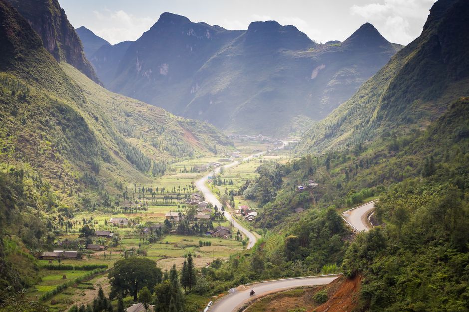
Ha Giang (Hà Giang), in Vietnam’s far north on the border with China, is the starting point of the Ha Giang Loop, a three- to five-day road journey of roughly 350 km (220 miles) through some of the most dramatic mountain scenery in Southeast Asia. North of the small riverside town, the road climbs onto the Dong Van Karst Plateau, a UNESCO Global Geopark of jagged gray limestone peaks, terraced valleys and deep canyons, home to Hmong, Dao, Tay, Lo Lo and other ethnic minority communities whose markets, villages and clothing are part of the journey’s appeal. The highlights include the Quan Ba Heaven Gate, the pine forests of Yen Minh, the Lung Cu flag tower at Vietnam’s northernmost point, the old quarter of Dong Van, and the Ma Pi Leng Pass high above the turquoise Nho Que River. Most travelers ride as passengers with experienced local drivers, called easy riders, rather than driving themselves. Ha Giang was its own province until July 2025, when it merged into Tuyen Quang province. The best months are September to November, for golden rice and buckwheat flowers, and March to May; from June to August, heavy rain brings landslides.
Right now in Ha Giang
- Wed18–30°C65–86°FClear
- Thu18–29°C65–84°FClear
- Fri19–30°C65–86°FClear
Top tours in Ha Giang
See all tours for Ha Giang →
From local operators, with prices and reviews; you check availability and book on Viator, our partner. We may earn a commission at no extra cost to you. How we earn money
Ha Giang at a glance
- Best for: the Ha Giang Loop by motorbike or car, mountain passes and karst landscapes, ethnic minority markets and villages, and rice terraces.
- How long: 3–4 days for the loop from Ha Giang town, plus travel days from Hanoi; 5–6 days with Hoang Su Phi’s rice terraces or extra nights on the plateau.
- Best time: September to November, for clear weather, golden rice and buckwheat flowers; March to May, for spring blossoms.
- Getting there: about 300 km (185 miles) from Hanoi, 6 to 7 hours by sleeper bus or limousine van.
- Getting around: by motorbike with an easy rider, by self-driven motorbike if licensed and experienced, or by private car with a driver.
- Permits: Vietnam restricts foreigners’ access to border areas; local tour operators and hostels arrange a border-area permit for the loop.
- Before you go: the e-visa, visa-free stays, money and general safety are in our Vietnam travel guide.
Ha Giang’s areas and where to stay
Ha Giang town
The former provincial capital, on the Lo River at only about 120 m (400 ft) above sea level, is a modest, pleasant town with hostels, guesthouses, motorbike rental shops and tour agencies around the center, where nearly everyone spends a night before and after the loop.
Quan Ba and Yen Minh
The first stage of the loop climbs to the town of Tam Son in Quan Ba district, with homestays in Tay and Hmong villages around the Heaven Gate, and continues to Yen Minh, a market town among pine forests.
Dong Van and Lung Cu
The heart of the plateau. Dong Van, at about 1,000 m (3,300 ft), has the loop’s widest choice of guesthouses and homestays around its old quarter and market; Lung Cu, near the northernmost point, has a few village homestays.
Meo Vac and Du Gia
East of the Ma Pi Leng Pass, Meo Vac has hotels and homestays near its Sunday market; Du Gia, on the southern return route, is a quiet valley village with a waterfall and Tay homestays, popular for a last night on the loop.
Top things to see on the Ha Giang Loop
Quan Ba Heaven Gate and the Twin Mountains
About 45 km (28 miles) north of Ha Giang town, the road climbs a series of switchbacks to the Quan Ba Heaven Gate (Cong Troi Quan Ba), a pass with a viewpoint over the valley below, where two rounded hills, known as the Twin Mountains or Fairy Bosom Mountains, rise from the rice fields.
Yen Minh pine forest and the Tham Ma Pass
Beyond Yen Minh, the road winds through pine forests and climbs the zigzag Tham Ma Pass, with views of terraced slopes and Hmong villages built from rammed earth and stone.
The Vuong family palace at Sa Phin
In the valley of Sa Phin, the fortified mansion of the Vuong family, Hmong leaders who ruled the region in the early 20th century, combines Chinese and Hmong architecture, with stone walls, carved wooden galleries and courtyards.
Lung Cu flag tower
At Lung Cu, near Vietnam’s northernmost point, a tower on Dragon Mountain flies a huge national flag over the border hills; climb the stairs for views across the plateau into China.
Dong Van old quarter and market
Dong Van’s small old quarter has traditional two-story houses with tiled roofs around its old market building; on Sundays, the town fills with people from surrounding villages in colorful dress, buying and selling livestock, vegetables, textiles and corn wine.
The Ma Pi Leng Pass and the Nho Que River
Between Dong Van and Meo Vac, the road clings to the cliffs of the Ma Pi Leng Pass, often called the most beautiful of Vietnam’s mountain passes, high above the jade-green Nho Que River in the Tu San canyon. A path leads down to the river, where boats take visitors into the gorge.
More classic sights
- Lung Tam linen village: Hmong women weave and dye hemp and linen cloth by hand.
- Meo Vac market: a lively Sunday market, with the famous Khau Vai love market held once a year in spring.
- Lung Khuy Cave: a cave of stalactites near Quan Ba with a walkway.
- Hoang Su Phi rice terraces: in the west of the former province, among the most spectacular terraces in Vietnam, best in September and October.
- Sung La valley: a village of earthen houses and buckwheat fields, used as a film set.
Other things to do in Ha Giang
The Dong Van Karst Plateau Geopark
Much of the loop runs through the Dong Van Karst Plateau Global Geopark, recognized by UNESCO in 2010 as Vietnam’s first global geopark, for its limestone landscapes, fossils and the cultures of the communities who live there. Visitor centers in Dong Van and along the route explain the geology and history.
Markets and ethnic minority culture
Weekly markets are the best place to meet the plateau’s peoples: the Hmong, the largest group; the Dao, Tay, Nung, Lo Lo, Giay and others, each with distinct dress. Many markets are held on Sundays, including Dong Van and Meo Vac, while others rotate through the week. Ask before photographing people, and buy textiles directly from weavers.
Trekking and homestays
Short treks lead from Du Gia, Lung Cu and Hoang Su Phi through terraces and villages, and many homestays offer cooking and dinner with the family, often with a round of homemade corn wine. See our hiking guide.
Food and drink
Try thang co, a Hmong stew of horse meat and offal, at the markets; men men, steamed corn flour; chao au tau, a rice porridge with au tau root, a Ha Giang specialty eaten in the evening; banh cuon with bone broth for breakfast; buckwheat cakes; smoked buffalo meat; and corn wine (ruou ngo), strong and best sampled in small cups. Shan Tuyet tea from ancient trees grows on the hills.
Beyond the loop
- Hoang Su Phi: a day’s drive west of Ha Giang town, with rice terraces, Shan Tuyet tea hills and homestays.
- Ba Be National Park: a lake among karst mountains, about 5 to 6 hours southeast, in the former Bac Kan province.
- Ban Gioc Waterfall: on the Chinese border in Cao Bang, about 6 to 8 hours east by mountain roads.
- Sa Pa: the other great northern mountain destination, about 7 to 8 hours west. See our Sa Pa guide.
- Hanoi: 6 to 7 hours by road. See our Hanoi guide.
Getting there and getting around
By bus from Hanoi
Sleeper buses and limousine vans leave Hanoi several times a day, mostly in the evening and morning, for the 6- to 7-hour journey to Ha Giang town, and many offer hotel pickups in the Old Quarter. Night buses arrive in the early morning, and many hostels let riders rest before starting the loop.
Easy riders, self-riding and cars
There are three ways to do the loop. Most foreign visitors book a tour with an easy rider, a local driver who carries you as a passenger on a semi-automatic or manual motorbike and acts as guide; tours include homestays, meals and the border permit. Experienced riders can rent a motorbike and ride themselves, but you need a license valid in Vietnam: Vietnam recognizes international driving permits issued under the 1968 Vienna Convention, together with your home license, and helmets are compulsory. Families and less adventurous travelers can hire a car or jeep with a driver.
The border-area permit
Vietnam’s regulations on land border areas (Decree 34/2014/ND-CP) control foreigners’ access to border zones: according to the Government of Vietnam’s news portal, foreign residents need a permit from the Ministry of Public Security’s immigration authority or the provincial police, and organizations bringing foreigners into a border area must carry papers and notify the provincial police and border guards in advance. Much of the loop, including Dong Van, Meo Vac and Lung Cu, lies close to the Chinese border. Since mid-2026, local tour operators and hostels have been arranging border-area permits for the loop, reported at about 200,000–250,000 VND (about US$8–10), although we could not find an official public notice setting this fee. Ask your operator to arrange the permit, carry your passport at all times, and register at your accommodation each night.
When to go and how long to stay
Ha Giang has a subtropical mountain climate with a hot, wet summer and a cool, dry winter, and conditions on the plateau, at 1,000–1,600 m (3,300–5,200 ft), are much colder than in the town. September to November is the best season: dry and clear after the rains, with golden rice terraces in September and early October and pink and white buckwheat flowers on the plateau from October to December. December to February is cold, often foggy, with frost and very occasionally snow on the highest passes. March to May brings peach and plum blossom, then warming weather. June to August is the rainy season, with heavy downpours, fog, and landslides that can close the loop’s roads, though the terraces are green. Neither the WMO nor Vietnam’s National Center for Hydro-Meteorological Forecasting (NCHMF) publishes 1991–2020 normals for Ha Giang on the WMO’s public lists, so the temperatures below come from Vietnam’s national technical regulation on natural conditions for construction, QCVN 02:2022/BXD, issued by the Ministry of Construction, for the Ha Giang town station at about 120 m (390 ft); expect temperatures about 6–9 °C (11–16 °F) lower on the Dong Van plateau. Rainfall is described from general sources.
| Month | Average high / low (Ha Giang town) | Typical rain | What to expect on the loop |
|---|---|---|---|
| January | 20 °C (67 °F) / 13 °C (56 °F) | Dry, drizzly | Cold and foggy on the plateau; frost possible |
| February | 21 °C (70 °F) / 15 °C (59 °F) | Dry, drizzly | Peach and plum blossom; Tet on February 6 in 2027 |
| March | 24 °C (76 °F) / 18 °C (64 °F) | Showers begin | Blossoms; mild days |
| April | 28 °C (83 °F) / 21 °C (70 °F) | Showers | Warm; spring festivals; Khau Vai love market in some years |
| May | 32 °C (89 °F) / 23 °C (74 °F) | Wet | Hot in the valleys; water-filled terraces |
| June | 32 °C (90 °F) / 25 °C (76 °F) | Very wet | Heavy rain; landslide risk |
| July | 33 °C (91 °F) / 25 °C (76 °F) | Very wet | Wettest period; roads may close |
| August | 33 °C (91 °F) / 25 °C (76 °F) | Very wet | Heavy rain; green terraces |
| September | 32 °C (89 °F) / 23 °C (74 °F) | Rain easing | Golden rice; good season begins |
| October | 29 °C (84 °F) / 21 °C (70 °F) | Mostly dry | Clear; buckwheat flowers; peak season |
| November | 25 °C (78 °F) / 17 °C (63 °F) | Dry | Buckwheat flowers; cool nights |
| December | 22 °C (71 °F) / 14 °C (57 °F) | Dry | Cold on the plateau; fewer visitors |
A classic 3-day loop
Day 1, Ha Giang town to Quan Ba Heaven Gate, the Twin Mountains, Yen Minh and Dong Van. Day 2, Lung Cu flag tower, the Vuong family palace, Dong Van old quarter, the Ma Pi Leng Pass and the Nho Que River, then Meo Vac. Day 3, the southern route via Mau Due and Du Gia back to Ha Giang town.
A 4- or 5-day loop
Add a night in Du Gia or Lung Cu, a boat trip on the Nho Que River and a Sunday market; or extend west to the Hoang Su Phi rice terraces.
Where to stay
- Ha Giang town: hostels, guesthouses and hotels near the center and bus station, convenient for tours and rentals.
- Dong Van: the most choice on the loop, from guesthouses in the old quarter to boutique homestays.
- Meo Vac, Yen Minh and Quan Ba: hotels and homestays along the route.
- Du Gia, Lung Cu and Lung Tam: family homestays in villages, simple but welcoming.
Homestays and rooms in Dong Van fill during the buckwheat flower season and Vietnamese holidays; book ahead.
What a trip to Ha Giang costs
Prices are approximate, for October 2026, converted at about 26,000 dong (VND) to the US dollar.
| Item | Typical cost |
|---|---|
| Sleeper bus or limousine van from Hanoi | 250,000–450,000 VND (about US$9.60–17) |
| 3-day loop with an easy rider, including homestays, meals and permit | 3,500,000–6,000,000 VND (about US$135–230) |
| Semi-automatic motorbike rental, per day | 200,000–350,000 VND (about US$7.70–13.50) |
| Border-area permit, arranged by an operator | about 200,000–250,000 VND (about US$8–10) |
| Homestay bed with dinner and breakfast | 250,000–500,000 VND (about US$9.60–19) |
| Boat on the Nho Que River | 150,000–250,000 VND per person (about US$5.80–9.60) |
| Bowl of chao au tau or thang co | 30,000–60,000 VND (about US$1.15–2.30) |
| Mid-range hotel double in Ha Giang town | 400,000–900,000 VND (about US$15–35) |
Practical tips for Ha Giang
- Ride as a passenger unless you are very experienced: the loop’s roads are steep, narrow and busy with trucks and buses.
- Check your insurance: many policies do not cover motorbike riding without a valid license.
- Carry cash: ATMs exist in Ha Giang town, Yen Minh, Dong Van and Meo Vac, but are few.
- Start early each day: to avoid riding in the dark and the afternoon fog and rain.
- Respect village life: ask before taking photos, and do not give money or sweets to children.
Safety
The Ha Giang Loop is beautiful but demanding, and road safety is the main concern. The roads are steep, narrow and winding, often without barriers, with blind corners, loose gravel, roadworks, heavy trucks and buses, livestock, and fog, rain or ice depending on the season; accidents involving tourists, many of them inexperienced self-riders, happen regularly. Ride slowly, wear a proper helmet, never ride after drinking (corn wine is often offered at homestays), and consider an experienced easy rider or a car with a driver. To drive a motorbike legally, you need a license valid in Vietnam, such as a 1968-convention international driving permit with your home license; if you are involved in an accident, the police may prevent you from leaving Vietnam until the matter is settled. In the rainy season, from May to September, landslides and rockfalls can block roads for hours or days; check conditions before setting off. Carry your passport and border-area permit, and do not cross into China or photograph military installations. Nights on the plateau can be cold enough for hypothermia when wet in winter. In an emergency, call 113 for police, 114 for fire and 115 for an ambulance; the nearest hospitals are in Ha Giang town and the district centers.
What to pack for Ha Giang
A warm jacket, gloves and layers (the plateau is cold in the mornings and from November to March), a waterproof jacket and trousers for riding, sturdy shoes, sunglasses and a buff against dust, sunscreen, a power bank, and your passport, driving license and permit. Vietnam uses 220 V, with sockets for flat (type A) and round (type C) two-pin plugs. See our rain jackets, hiking shoes and travel adapters guides.
Ha Giang travel FAQ
Do I need a permit for the Ha Giang Loop?
Vietnam’s land border regulations (Decree 34/2014/ND-CP) restrict foreigners’ access to border areas, and much of the loop runs close to the Chinese border. Tour operators and hostels arrange a border-area permit for the loop, reported at about 200,000–250,000 VND; carry it with your passport.
How long is the Ha Giang Loop?
About 350 km (220 miles), usually done in three or four days from Ha Giang town.
Can I ride the Ha Giang Loop myself?
Only if you are an experienced rider with a license valid in Vietnam, such as a 1968-convention international driving permit with your home license. Most visitors ride with an easy rider instead.
What is the best time for the Ha Giang Loop?
September to November, for golden rice, buckwheat flowers and clear weather; March to May is also good. Avoid the heavy rains of June to August.
How do I get from Hanoi to Ha Giang?
By sleeper bus or limousine van in about 6 to 7 hours.
Is the Ha Giang Loop dangerous?
The roads are steep and winding, with trucks, fog and landslides, and accidents are common among inexperienced riders. Riding with an experienced easy rider, slowly and in daylight, reduces the risk.
What is an easy rider?
A local motorbike driver and guide who carries you as a passenger around the loop, handling the riding, route and homestays.
When are the buckwheat flowers in Ha Giang?
Usually from October to December on the Dong Van plateau, at their peak in November.
Which province is Ha Giang in now?
Tuyen Quang. Ha Giang province merged into Tuyen Quang in July 2025, and the loop now lies in the northern part of the enlarged province.
Can I visit Lung Cu, the northernmost point of Vietnam?
Yes. The Lung Cu flag tower is a standard stop on the loop, about 25 km (15 miles) from Dong Van.
Plan your trip
Partner links: TravelerCenter may earn a commission if you book, at no extra cost to you.
🇻🇳 Useful Vietnamese phrases for Ha Giang
All 38 Vietnamese phrases: restaurant, hotel, emergencies, romance (printable) →
Sources · last reviewed 4 October 2026
Researched and last reviewed on 4 October 2026. Border-area rules for foreigners: Vietnam’s Decree 34/2014/ND-CP on land border areas, as summarized by the Government of Vietnam’s news portal (baochinhphu.vn); the 2026 permit arrangements and price reported for the loop: Time Out ( secondary; no official notice found ); the 2025 merger of Ha Giang into Tuyen Quang: the Government of Vietnam’s news portal; driving permits, helmets and exit bans after accidents: the UK government’s travel pages (factual content only); monthly temperatures for the Ha Giang station: Vietnam’s Ministry of Construction, QCVN 02:2022/BXD (read via luatvietnam.vn); exchange rate: Vietcombank. The loop’s length and route, the 2010 geopark recognition, sight descriptions, market days, flower seasons, plateau temperature differences, travel times and all typical prices are general references or estimates, flagged for checking. Rules and prices change, so check with your operator before you go. For entry rules, money and general safety, see our Vietnam travel guide.
Data: Weather: MET Norway (CC BY 4.0) · Rates: ECB · Costs: World Bank ICP and price levels · Wikidata (CC0)