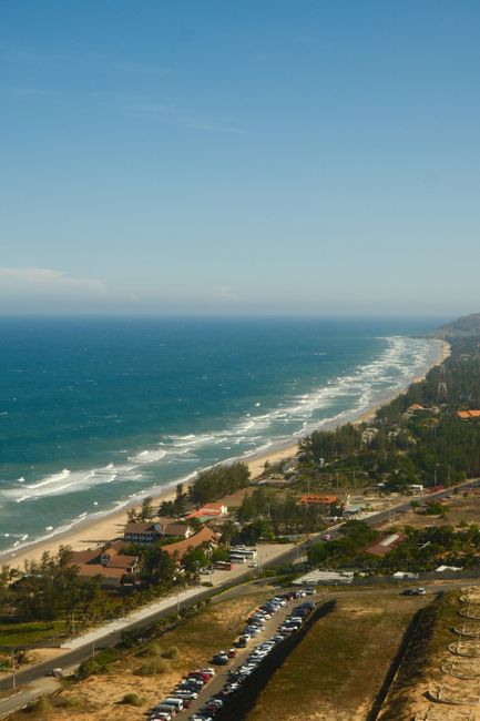
Mui Ne (Mũi Né), on the south-central coast about 200 km (125 miles) east of Ho Chi Minh City, grew from a fishing village into one of Vietnam’s best-known beach resorts after foreign travelers came to watch the solar eclipse of 1995. Its long strip of resorts, seafood restaurants and kitesurf schools runs along the bay east of the city of Phan Thiet, backed by some of the most surprising landscapes in Southeast Asia: rolling red and white sand dunes, the orange-walled Fairy Stream, and a harbor crowded with blue fishing boats and round basket boats. Mui Ne is one of the driest and windiest places in Vietnam, which makes it Asia’s best-known kitesurfing and windsurfing spot from November to April. It is also within easy reach of the Ta Cu mountain’s reclining Buddha, the Ke Ga lighthouse and the Cham towers of Po Sah Inu. Since the 2025 provincial merger, Mui Ne, formerly in Binh Thuan province, has been a ward of Lam Dong province. The driest months are December to April; from May to October, short tropical showers fall more often, and the sea is calmer for swimming.
Right now in Mui Ne
- Wed24–31°C75–87°F26 mm rain
- Thu24–30°C74–86°F13 mm rain
- Fri24–28°C74–82°F7 mm rain
Top tours in Mui Ne
See all tours for Mui Ne →
From local operators, with prices and reviews; you check availability and book on Viator, our partner. We may earn a commission at no extra cost to you. How we earn money
Mui Ne at a glance
- Best for: beaches, sand dunes, kitesurfing and windsurfing, seafood, fishing-village life and a beach break from Ho Chi Minh City.
- How long: 2–3 days for the dunes and beach; a week or more for a kitesurfing course.
- Best time: December to April for dry, sunny weather and strong winds; May to October for calmer seas and fewer crowds.
- Getting there: about 3.5 to 4 hours by road from Ho Chi Minh City on the North–South Expressway, or by train to Phan Thiet and a 30-minute taxi.
- Getting around: by Grab, taxi or rented motorbike along the coast road; jeep tours for the dunes.
- Good to know: the beach in the central resort strip has eroded badly in places; many resorts have seawalls, and the widest beaches are at the eastern and western ends of the bay.
- Before you go: the e-visa, visa-free stays, money and general safety are in our Vietnam travel guide.
Mui Ne’s areas and where to stay
The resort strip follows the coast road, Nguyen Dinh Chieu, for about 15 km (9 miles) from Phan Thiet to the fishing village of Mui Ne itself, at the eastern tip of the bay.
Ham Tien and the central strip
The middle of the bay has the largest concentration of resorts, guesthouses, restaurants, bars and kitesurf schools, all along the main road. Beaches here are narrow and protected by seawalls in places.
Mui Ne fishing village
At the eastern end, the original village and its harbor are full of colorful boats, basket boats and fish-drying yards; small hotels and seafood restaurants are close by, near the Red Sand Dunes.
Phan Thiet
The provincial town to the west, on the Ca Ty River, has its own beaches, the Po Sah Inu towers, the railway station, local markets and a few large resorts and golf courses on its northern edge.
Hon Rom and the north coast
Beyond Mui Ne village, the quieter coast toward Hon Rom and the White Sand Dunes has a few beach resorts and wide, less developed beaches.
Top things to see in Mui Ne
The White Sand Dunes (Bau Trang)
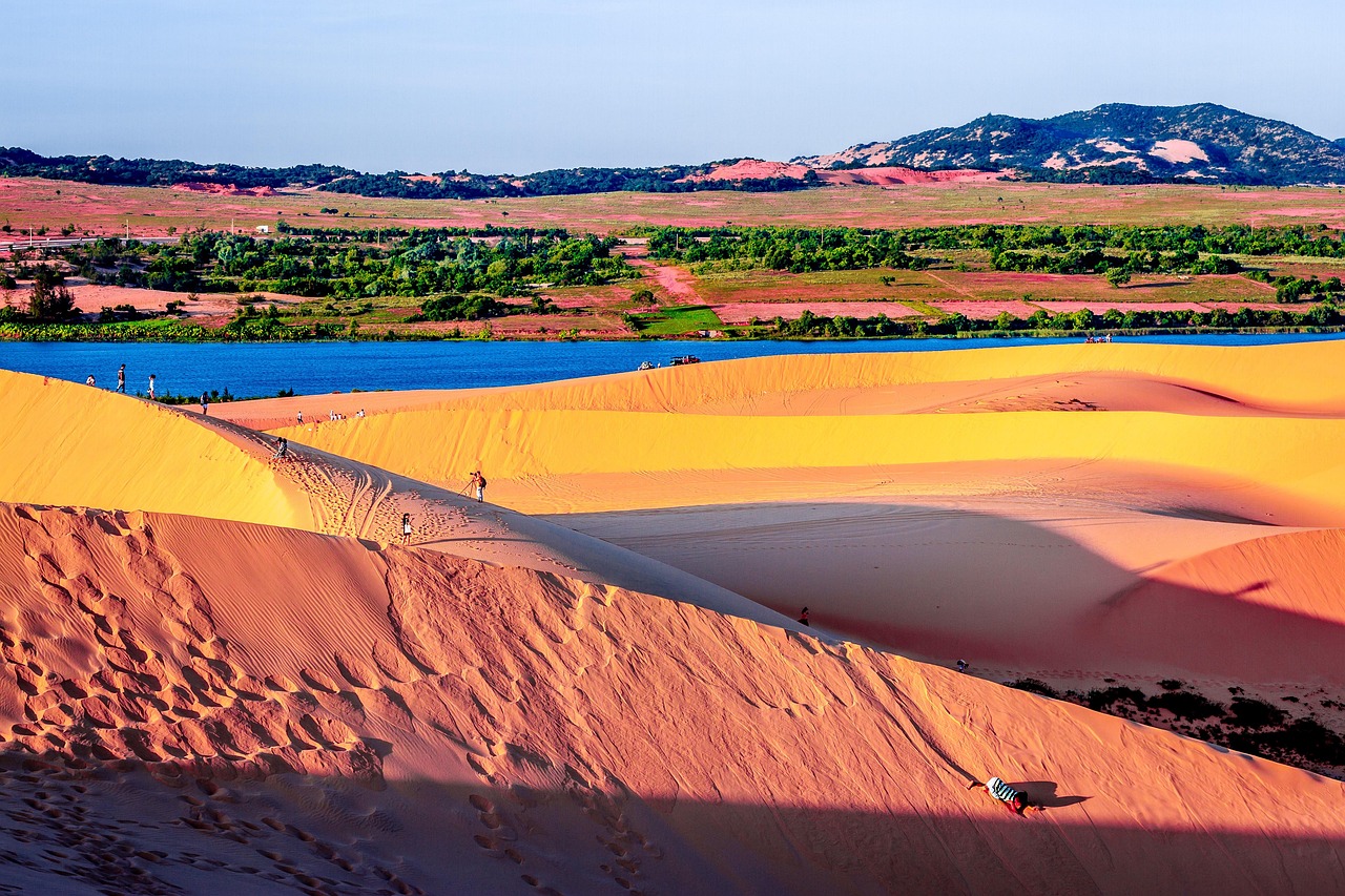
About 25 km (15 miles) northeast of the village, huge white dunes stretch inland around the freshwater Bau Trang lakes, covered in lotus in season. Sunrise jeep tours arrive in the early morning, when the sand is cool and the light is golden. Quad bikes and dune buggies are rented at the entrance; they are noisy and accidents happen, so ride carefully or walk.
The Red Sand Dunes (Doi Cat Do)
Closer to the village, the smaller, rust-red dunes are a favorite at sunset, when local children rent plastic sleds for sliding down the slopes.
The Fairy Stream (Suoi Tien)
A shallow stream winds for about 1.5 km (1 mile) between eroded cliffs of red, orange and white sandstone and clay, like a miniature canyon. Walk barefoot up the stream from the coast road, ankle-deep in water, to a small waterfall.
Mui Ne fishing village and harbor
In the early morning, fishing boats return to the harbor, and women in conical hats sell the catch on the beach. Hundreds of round basket boats (thung chai) bob in the bay; the viewpoints above the harbor are best at dawn.
The Cham towers of Po Sah Inu
On a hill just east of Phan Thiet, three brick towers built by the Cham kingdom in the late 8th or early 9th century overlook the sea, among the oldest surviving Cham monuments in southern Vietnam.
More classic sights
- Ta Cu Mountain: a cable car climbs to a pagoda complex with a 49 m (161 ft) reclining Buddha, about 1.5 hours southwest of Phan Thiet.
- Ke Ga Lighthouse: built by the French at the end of the 19th century on an islet off Ke Ga cape, about 1 hour southwest, one of the oldest lighthouses in Vietnam.
- Fish sauce factories: Phan Thiet is famous for nuoc mam; some workshops and a museum show how it is made.
- Dragon fruit farms: the area is Vietnam’s main grower of dragon fruit, with farms lit at night to boost flowering.
Phan Thiet town
Phan Thiet, the former provincial capital at the western end of the bay, is a working fishing port rather than a resort. Walk along the Ca Ty River, where fishing boats crowd the quays; visit the Duc Thanh School, where the young Ho Chi Minh taught in 1910–1911, now part of a museum; and see the water tower that has become the town’s symbol. The central market and the riverside seafood stalls are lively in the evening.
Cham heritage
Before the Vietnamese arrived, this coast belonged to the Hindu kingdom of Champa, and Cham communities still live in villages inland from Phan Thiet and around Phan Rang to the north. Besides the Po Sah Inu towers, the Cham celebrate the Kate festival at their temples in autumn, usually in October, with music, dances and offerings.
Other things to do in Mui Ne
Kitesurfing and windsurfing
From about November to April, the northeast monsoon blows steadily across the bay, often at 15–25 knots, making Mui Ne one of Asia’s best-known kitesurfing and windsurfing destinations. Dozens of schools offer lessons, from taster sessions to multi-day courses with international certification, and equipment rental. Beginners should learn in the morning, when the wind is gentler, and stay within the school’s supervised area.
Beaches and swimming
The best beaches are at the eastern and western ends of the bay and north toward Hon Rom. In the windy season, the sea is choppy, with waves and strong currents; from May to October, it is generally calmer. See our beaches and surfing guides.
Food and drink
Mui Ne is a seafood town. At the open-air restaurants along the beach road, choose live crabs, lobster, scallops, squid and fish from tanks to be grilled with salt, chili and lime or cooked in a hotpot. Try banh can, small rice-flour pancakes cooked in clay molds; banh xeo; goi ca mai, raw fish salad; and the local dried squid and fish sauce. Dragon fruit is everywhere. The resort strip has international restaurants and beach bars.
Golf and spas
Several championship golf courses lie between Phan Thiet and Mui Ne, and most resorts have spas.
Mui Ne with children
Many resorts have family rooms, kids’ pools and gardens. Children enjoy sledding on the Red Sand Dunes, splashing up the Fairy Stream and watching the basket boats in the harbor, and calmer seas from May to October make swimming easier; keep children well away from kitesurfing areas.
Day trips from Mui Ne
- Ta Cu Mountain and Ke Ga Lighthouse: a half- or full-day trip southwest along the coast.
- Phan Thiet: the Po Sah Inu towers, the Duc Thanh school where Ho Chi Minh once taught, markets and the riverfront.
- Bau Trang and the north coast: the White Sand Dunes and lakes, with the fishing villages beyond.
- Da Lat: about 4 hours inland by road into the highlands. See our Da Lat guide.
- Ho Chi Minh City: about 3.5 to 4 hours by road. See our Ho Chi Minh City guide.
Nearby destinations
- Da Lat108 km
- Ho Chi Minh City171 km
- Nha Trang174 km
Getting there and getting around
By road
Since the opening of the expressway sections between Dau Giay and Phan Thiet, the drive from Ho Chi Minh City takes about 3.5 to 4 hours. Sleeper buses and limousine vans run several times a day from District 1 and the bus stations, dropping passengers at hotels along the resort strip. Buses also link Mui Ne with Da Lat (about 4 hours) and Nha Trang (about 4 to 5 hours).
By train
Vietnam Railways runs trains from Saigon Station in Ho Chi Minh City to Phan Thiet, taking about 4 hours; tickets are sold on dsvn.vn. From Phan Thiet station, taxis and Grab take about 30 minutes to the resort strip.
By air
There is no civil airport in Mui Ne yet. The nearest airports are Tan Son Nhat (SGN) in Ho Chi Minh City and Lien Khuong (DLI) near Da Lat. Construction of a civil terminal at Phan Thiet’s military airport began in 2026, with opening expected in the coming years.
Around Mui Ne
The coast road is the only main road, so Grab, taxis and local buses run up and down it easily. Motorbikes can be rented by licensed riders, and jeeps with drivers take visitors to the dunes. Bicycles are pleasant early in the morning.
When to go and how long to stay
Mui Ne lies in one of the driest parts of Vietnam, sheltered by mountains, with lots of sunshine. The dry season, from November or December to April, is sunny and windy, with very little rain and the best kitesurfing; it is also the busiest season, especially around Christmas, Tet and Easter. The rainy season, from May to October, brings short, heavy afternoon showers, but many days are still sunny, the wind drops and the sea is calmer. Neither the WMO nor Vietnam’s National Center for Hydro-Meteorological Forecasting (NCHMF) publishes 1991–2020 normals for Phan Thiet on the WMO’s public lists, so the temperatures below come from Vietnam’s national technical regulation on natural conditions for construction, QCVN 02:2022/BXD, issued by the Ministry of Construction, for the Phan Thiet station; rainfall is described from general sources.
| Month | Average high / low | Typical rain | What to expect |
|---|---|---|---|
| January | 29 °C (85 °F) / 21 °C (70 °F) | Dry | Sunny and windy; prime kitesurfing |
| February | 30 °C (85 °F) / 22 °C (72 °F) | Driest month | Dry and windy; Tet on February 6 in 2027 |
| March | 31 °C (87 °F) / 24 °C (74 °F) | Dry | Sunny; strong winds continue |
| April | 32 °C (89 °F) / 25 °C (78 °F) | Mostly dry | Hot; winds easing |
| May | 33 °C (91 °F) / 26 °C (78 °F) | Rainy season begins | Hottest month; afternoon storms |
| June | 32 °C (90 °F) / 25 °C (77 °F) | Showers | Calm seas; quieter |
| July | 32 °C (89 °F) / 25 °C (76 °F) | Showers | Sunny mornings; calm sea |
| August | 32 °C (89 °F) / 25 °C (76 °F) | Showers | Mixed; good for swimming |
| September | 31 °C (88 °F) / 25 °C (76 °F) | Wetter | Afternoon storms |
| October | 31 °C (88 °F) / 24 °C (76 °F) | Wettest period | Heavier rain; occasional storms offshore |
| November | 31 °C (87 °F) / 23 °C (74 °F) | Drying out | Winds return; kitesurf season begins |
| December | 30 °C (86 °F) / 22 °C (72 °F) | Mostly dry | Windy and sunny; holiday crowds |
2 days in Mui Ne
Day one, a sunrise jeep trip to the White Sand Dunes, the fishing harbor and the Fairy Stream, with a seafood dinner on the beach road. Day two, a kitesurfing taster or beach morning, the Cham towers in the afternoon, and sunset at the Red Sand Dunes.
4 days with the coast
Add a day trip to Ta Cu Mountain and Ke Ga Lighthouse and a lazy day by the pool or on the northern beaches.
Where to stay in Mui Ne
- Central strip (Ham Tien): most resorts, guesthouses and kitesurf schools, close to restaurants and bars.
- Near the fishing village: smaller hotels and homestays near the harbor and Red Sand Dunes.
- Phan Thiet’s coast: larger resorts and golf hotels west of the strip.
- Hon Rom and the north: quiet beach resorts with wider sand.
Rooms fill around Tet, Vietnamese holidays and the European winter season; book ahead.
What a trip to Mui Ne costs
Prices are approximate, for October 2026, converted at about 26,000 dong (VND) to the US dollar.
| Item | Typical cost |
|---|---|
| Sunrise jeep tour to the dunes and Fairy Stream, shared | 150,000–300,000 VND (about US$5.80–11.50) |
| Quad bike on the White Sand Dunes, 15–30 minutes | 300,000–800,000 VND (about US$11.50–31) |
| Kitesurfing lesson, per hour with instructor | 1,500,000–2,500,000 VND (about US$58–96) |
| Seafood dinner for two on the beach road | 500,000–1,200,000 VND (about US$19–46) |
| Banh can or banh xeo | 30,000–60,000 VND (about US$1.15–2.30) |
| Limousine van or bus from Ho Chi Minh City | 200,000–400,000 VND (about US$7.70–15.50) |
| Train Saigon–Phan Thiet | 150,000–300,000 VND (about US$5.80–11.50) |
| Mid-range resort double, per night | 900,000–2,500,000 VND (about US$35–96) |
Practical tips for Mui Ne
- Go to the dunes at sunrise: the sand burns by mid-morning, and light and colors are best early.
- Agree prices first: for quad bikes, sleds and seafood sold by weight, ask the price before you start.
- Check the beach before booking: erosion has left some resorts with little or no sand at high tide.
- Learn kitesurfing with certified schools: and listen to the instructors on wind and safety zones.
- Carry cash: small restaurants and dune vendors prefer cash; ATMs are on the main road.
Safety
Mui Ne is relaxed and generally safe. In the windy season, from November to April, the sea can be rough, with strong currents and waves; swim where others do, near lifeguards if possible, and avoid swimming in kitesurfing zones. Quad bikes and dune buggies on the White Sand Dunes cause injuries every year; wear a helmet, ride slowly, and stay away from steep edges. The coast road is busy with buses and motorbikes; use Grab or taxis at night. Sun and heat are intense on the dunes, so carry water and wear a hat. Petty theft and bag snatching occur occasionally on the beach road. In the rainy season, tropical storms offshore can bring heavy rain and rough seas. In an emergency, call 113 for police, 114 for fire and 115 for an ambulance.
What to pack for Mui Ne
Light clothes, swimwear, a hat, sunglasses and high-factor sunscreen, sandals for the Fairy Stream, a light layer for windy evenings, and a rash guard for water sports. Vietnam uses 220 V, with sockets for flat (type A) and round (type C) two-pin plugs. See our water shoes, wetsuits and travel adapters guides.
Mui Ne travel FAQ
How do I get from Ho Chi Minh City to Mui Ne?
By bus or limousine van in about 3.5 to 4 hours via the expressway, or by train to Phan Thiet in about 4 hours and a 30-minute taxi.
What is the best time to visit Mui Ne?
December to April for dry, sunny weather and kitesurfing; May to October for calmer seas and lower prices.
Is Mui Ne good for kitesurfing?
Yes. From about November to April, steady northeast winds make it one of Asia’s best kitesurfing spots, with many schools and rental centers.
Are the Mui Ne sand dunes worth visiting?
Yes, especially the White Sand Dunes at sunrise and the Red Sand Dunes at sunset.
How many days do I need in Mui Ne?
Two or three days for the dunes, the Fairy Stream and the beach; longer for a kitesurfing course or relaxing.
Does Mui Ne have a good beach?
The bay is long, but erosion has narrowed the central strip; the best beaches are at the ends of the bay and north toward Hon Rom.
Is there an airport in Mui Ne?
Not yet. Fly to Ho Chi Minh City or Lien Khuong near Da Lat; a civil terminal at Phan Thiet is under construction.
Which province is Mui Ne in?
Lam Dong, since the July 2025 merger of Binh Thuan into Lam Dong; before that, it was in Binh Thuan province.
Can I go from Mui Ne to Da Lat?
Yes, by bus or car in about 4 hours through the mountains. See our Da Lat guide.
Is the sea safe for swimming in Mui Ne?
Usually, in calm conditions, but waves and currents can be strong in the windy season; swim with care and away from kitesurfers.
Plan your trip
Partner links: TravelerCenter may earn a commission if you book, at no extra cost to you.
🇻🇳 Useful Vietnamese phrases for Mui Ne
All 38 Vietnamese phrases: restaurant, hotel, emergencies, romance (printable) →
Sources · last reviewed 4 October 2026
Researched and last reviewed on 4 October 2026. Monthly temperatures for the Phan Thiet station: Vietnam’s Ministry of Construction, QCVN 02:2022/BXD (read via the legal database luatvietnam.vn); the 2025 provincial merger: the Government of Vietnam’s news portal; train booking: Vietnam Railways; exchange rate: Vietcombank. The 1995 eclipse story, dune, stream and tower descriptions and dates, the Ta Cu and Ke Ga details, wind speeds and seasons, beach erosion, expressway journey times, the Phan Thiet airport construction start (2026), rainfall seasons and all typical prices are general references or estimates, flagged for checking. Prices change, so check before you go. For entry rules, money and general safety, see our Vietnam travel guide.
Data: Weather: MET Norway (CC BY 4.0) · Sea temperature: NOAA CoastWatch · Rates: ECB · Costs: World Bank ICP and price levels · Wikidata (CC0)