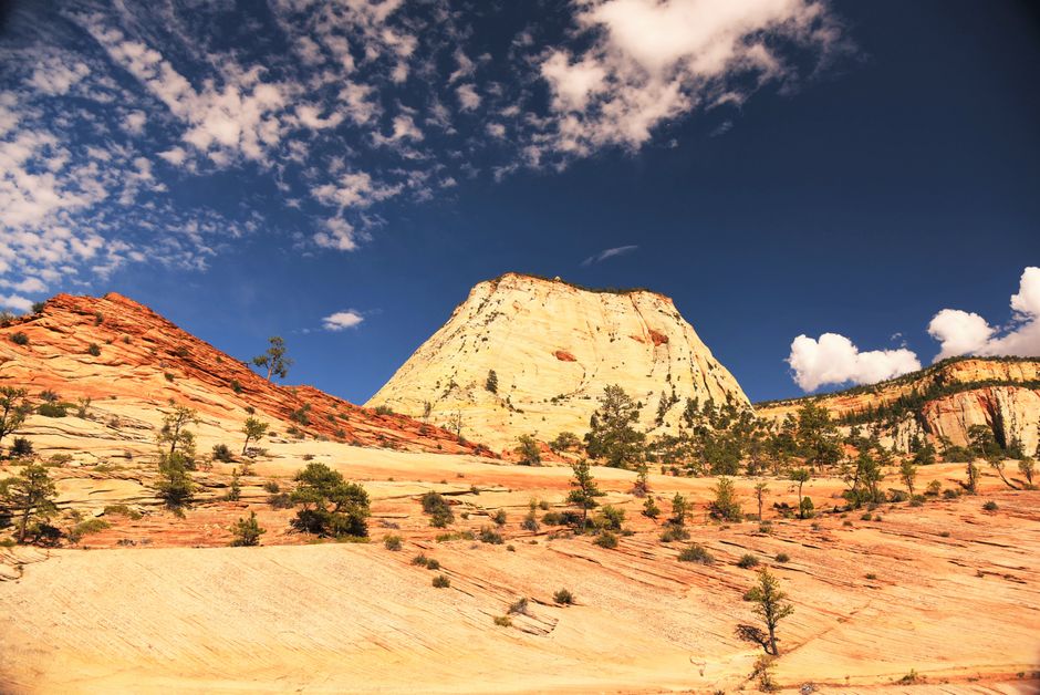
Zion National Park, Utah’s oldest national park, protects a deep, narrow canyon carved by the North Fork of the Virgin River through towering walls of red, pink and cream Navajo sandstone. On the canyon floor, cottonwoods shade the river and hanging gardens drip from the cliffs; above, peaks like the Watchman, the Court of the Patriarchs and Angels Landing glow at sunset. You can stroll a paved riverside path, wade upstream into The Narrows, or climb the chain-lined ridge to Angels Landing with a permit. For most of the year a free shuttle replaces private cars on the Zion Canyon Scenic Drive, and the small town of Springdale sits right at the South Entrance with hotels, restaurants and its own free shuttle. Summer is very hot and flash floods are a real danger, so plan around the weather, the shuttle and the permits.
Right now in Zion National Park (Zion Canyon)
- Tue13–30°C55–86°FMostly clear
- Wed12–31°C54–87°FClear
- Thu13–30°C55–86°FClear
- Mon 12 Oct Columbus Day · regional holiday in Utah
Top tours in Zion National Park
See all tours for Zion National Park →
From local operators, with prices and reviews; you check availability and book on Viator, our partner. We may earn a commission at no extra cost to you. How we earn money
Zion at a glance
- Best months: April–May and late September–November, for warm days and cooler nights. Summer often passes 100 °F (38 °C), with flash floods in the monsoon; winter is quiet, with cold, sometimes icy trails.
- Time needed: one full day for the shuttle stops, Riverside Walk and Emerald Pools; two or three days to add Angels Landing or a long Narrows hike and Kolob Canyons.
- Getting there: Springdale and the South Entrance are about 2.5–3 hours by car from Las Vegas (Harry Reid International Airport is 170 miles / 274 km away), 49 miles (79 km) from St. George airport and 300 miles (483 km) from Salt Lake City airport.
- Fees (as of October 2026): $35 per car for 7 days, plus $100 per person for non-US residents aged 16 and over without an annual or America the Beautiful pass. No entry reservation is needed.
- Before you go: entry rules for international visitors (ESTA or visa), driving and tipping are in our United States travel guide.
Entrance fees and passes (as of October 2026)
Everyone who enters Zion, even just to drive through on the Zion-Mt. Carmel Highway, needs a pass. Buy it at any entrance station (cards preferred, cash accepted) or online. You don’t need to display it, but keep it with you: if you park in Springdale and walk back in through the pedestrian entrance, rangers will ask to see it.
| Pass | Price | What it covers |
|---|---|---|
| Private vehicle | $35 | One non-commercial car or van (up to 15 seats) and everyone in it, 7 days |
| Motorcycle | $30 | Up to 2 motorcycles, 4 riders, 7 days |
| Per person (foot or bike) | $20 | Each person 16 or over; under-16s free; 7 days |
| Non-resident fee | +$100 per person | Non-US residents 16 and over, unless entering with an annual or America the Beautiful pass; also charged on commercial tours |
| Zion annual pass | $70 | This park only, 12 months; US citizens and residents |
| America the Beautiful pass | $80 residents / $250 non-residents | All national parks and federal recreation lands for 12 months; one vehicle or four people paying per person |
For international visitors: two adults from abroad in a rental car would pay $35 plus $200 in non-resident fees at Zion alone. The $250 non-resident America the Beautiful pass covers the car’s entrance and waives the $100 fee for the pass holder and up to three other adults, so it pays for itself on a single visit and also covers Bryce Canyon, Arches and the Grand Canyon. US seniors 62 and over can buy a $20 annual or $80 lifetime pass; US military, US 4th graders and US residents with a permanent disability get free passes. US citizens and residents enter free on the remaining 2026 fee-free days, 27 October and 11 November; permit and campground fees still apply.
The Zion Canyon shuttle and the Scenic Drive
From early spring to late fall, the 8-mile (13 km) Zion Canyon Scenic Drive is closed to private cars, including before the first and after the last bus, and you reach Angels Landing, the Emerald Pools and The Narrows on the free park shuttle. No ticket or reservation is needed. Buses come every 5–10 minutes and take about 45 minutes from the Zion Canyon Visitor Center to the Temple of Sinawava at the end of the road, so a round trip takes about an hour and a half. Only Zion Lodge guests and horse-ride customers with reservations may drive up to their parking areas.
| Dates (2026–27) | First bus from the Visitor Center | Last bus from the Visitor Center | Last bus out from the Temple of Sinawava |
|---|---|---|---|
| 13 September to 24 October | 7 a.m. | 6 p.m. | 7:15 p.m. |
| 25 October to 28 November | 7 a.m. | 5 p.m. | 6:15 p.m. |
| 29 November to 25 December | No shuttle: you may drive the Scenic Drive | ||
| 26 December to 2 January | 8 a.m. | 4:30 p.m. | 5:45 p.m. |
Don’t wait for the last bus: if it is full or you miss it, the walk back to the Visitor Center is about 8–9 miles (13–14 km) in the dark. The park has not yet published its 2027 shuttle season; in most years buses run daily from March through November plus the holiday week, and you can drive the Scenic Drive in the off-season, though rangers close it for the day when its parking fills, often in winter. Bikes and strollers go on the front rack (no fat-tire or e-bikes); there is no eating on board, and pets are not allowed.
The Springdale Line is a second free shuttle with nine stops through town, from the Hotel De Novo at the south end to Zion Canyon Village by the pedestrian entrance. Until 24 October it runs 8 a.m.–7 p.m., then 8 a.m.–6 p.m. until 28 November, every 10–15 minutes. The Visitor Center’s lot (about 350 spaces) is usually full by early or mid-morning from February to November; parking in Springdale costs extra but the shuttle makes it easy. SunTran also runs a Zion route from St. George via Hurricane and Springdale.
Angels Landing permits for 2026 and early 2027
Everyone who climbs the chain section beyond Scout Lookout needs a permit, issued by lottery on Recreation.gov under the park’s pilot program. You don’t need one to hike the West Rim Trail as far as Scout Lookout. Each application costs $6 (non-refundable) and covers up to six people; if you win, you pay $3 per person.
- Day-before lottery: apply between 12:01 a.m. and 3 p.m. Mountain Time on the day before your hike; results come at 4 p.m. Day-before permits cannot be changed or refunded. There are no same-day permits; Zion Lodge has free Wi-Fi if you need to apply from the park.
- Seasonal lottery: choose up to seven ranked days or windows. For hikes from 1 December 2026 to 28 February 2027, apply from 8 a.m. MT on 1 October to 11:59 p.m. MT on 20 October 2026; permits are issued on 25 October. You can cancel or reduce your group up to two days before for a refund of the $3 fees; cancelled permits go into the day-before lottery.
- Spring 2027 onward: as of October 2026 the park had published lottery dates only through February 2027. In 2026 the spring window (for March–May hikes) opened in mid-February, so expect something similar; check the Angels Landing page on nps.gov before you plan.
Your permit is the Recreation.gov confirmation email: print or download it, as there is almost no phone signal in the canyon, and bring photo ID. The time on it is when you should be at the Grotto (shuttle stop 6). The hike is 5.4 miles (8.7 km) round trip with 1,488 ft (454 m) of climbing and takes most people about 4 hours, including the 21 tight switchbacks of Walter’s Wiggles. The final half mile (800 m) follows a knife-edge ridge with a single chain, where most of the fatal accidents since 1930 have happened. Don’t go up if storms are near, the rock is wet or icy, it will be dark before you finish, or anyone in your group is afraid of heights. Scout Lookout, about 2.25 miles (3.6 km) and 1,000 ft (305 m) up from the Grotto, is a fine turnaround with no permit.
Hiking The Narrows
The Narrows is the slimmest part of Zion Canyon, where walls about 1,000 ft (300 m) high close in until the river is only 20–30 ft (6–9 m) wide. From the Temple of Sinawava (shuttle stop 9), the paved Riverside Walk runs 1 mile (1.6 km) to the end of the trail; after that, the trail is the river itself. Hiking upstream needs no permit as far as Big Spring, a strenuous 10-mile (16 km) round trip, though even an hour in the water is memorable. The 16-mile (26 km) top-down hike from Chamberlain’s Ranch needs a wilderness permit and your own transport to the trailhead.
- When it closes: whenever the Virgin River flows above 150 cubic feet per second (cfs), usually for weeks in spring snowmelt, and whenever the National Weather Service issues a Flash Flood Warning, staying closed for at least two hours after it ends. Below 70 cfs you’ll wade knee-deep with pools to the waist; at 70–150 cfs crossings reach the thigh and pools the chest.
- Best time: summer and early fall, when the water is lowest and warmest (56–68 °F / 13–20 °C in summer; 41–53 °F / 5–12 °C in spring and fall), but monsoon storms bring the most flash floods from mid to late summer.
- What to wear: sturdy closed-toe shoes (never sandals or bare feet), a walking stick, layers in a dry bag and water-resistant bags for phones. Outfitters in Springdale rent canyoneering shoes, neoprene socks and drysuits for colder months.
- Toxic cyanobacteria: the park warns visitors not to put their heads under the water or drink from the river or streams; bring water from the taps.
Flash floods and heat safety
Flash floods can come from storms miles away, under blue sky, and send a wall of water 12 ft (3.7 m) high or more down a slot canyon within minutes. Before entering The Narrows or any narrow canyon, check the National Weather Service flash flood potential at a visitor center or online. Its ratings are “not expected”, “possible”, “probable” and “expected”; treat anything above “not expected” as a reason to change plans. If the water turns muddy, debris appears, you hear a roar up-canyon or thunder rolls in, climb to high ground at once and stay there; water usually drops within 24 hours.
Heat: summer days in Zion Canyon regularly pass 100 °F (38 °C), and the average July high at the park’s weather station is 100 °F (38 °C). The park suggests a gallon (4 liters) of water per person per day; drink it, eat salty snacks, hike early in the morning and rest in the shade at midday. The open trails near the South Entrance, such as the Watchman and Pa’rus areas, have very little shade. Heat illness, falls and rockfall are the park’s most common emergencies, and there is little or no mobile signal in Zion Canyon: call 911 if you can, or find a ranger.
Top things to see in Zion
Zion Canyon Scenic Drive by shuttle
Ride to the end and work your way back, getting off where you like (some stops are southbound only). Highlights include the Zion Human History Museum, the three peaks of the Court of the Patriarchs (a short paved path to a viewpoint), Zion Lodge’s shady lawn, the Grotto, and Big Bend, where you can often spot climbers on the walls and look up at Angels Landing. The recorded narration on the bus tells the story of the Southern Paiute, the pioneers and the geology.
Riverside Walk and the Temple of Sinawava
The easy, mostly paved Riverside Walk follows the river for 1 mile (1.6 km) each way from the natural amphitheater of the Temple of Sinawava to the start of The Narrows, past hanging gardens of ferns and wildflowers. It is accessible with some assistance for wheelchairs.
Emerald Pools
From Zion Lodge, cross the river to the Lower Emerald Pool and its small waterfall, 1 mile (1.6 km) round trip with 80 ft (24 m) of climbing. Continue to the Upper Emerald Pool beneath a sheer cliff: a moderate 3-mile (4.8 km) round trip with 360 ft (110 m) of gain. The pools are fragile wildlife water sources, so don’t wade or swim.
Pa’rus Trail and the Watchman
The paved Pa’rus Trail follows the river from the Visitor Center toward Canyon Junction, with views of the Watchman. It is the only trail open to bicycles and to pets on a leash. The Watchman Trail itself has been closed since 31 August 2026 pending repairs; check before you go.
Zion-Mt. Carmel Highway and the east side
Open to cars all year, this road climbs switchbacks above Pine Creek and through the 1930 Zion-Mt. Carmel Tunnel into slickrock country, where checkerboard-patterned sandstone and bighorn sheep are common sights. Just past the tunnel’s east end, the short Canyon Overlook Trail leads to a view down into lower Zion Canyon. Observation Point can’t be reached from Zion Canyon because a large rockfall closed part of the East Rim Trail; it can only be reached from the east.
Vehicle limits: vehicles longer than 35 ft 9 in (10.9 m), wider than 7 ft 10 in (2.39 m), taller than 11 ft 4 in (3.45 m), heavier than 50,000 lb (22,680 kg), or combinations longer than 50 ft (15.24 m) cannot drive between Canyon Junction and the East Entrance at all. Measurements include mirrors and bike racks. Large RVs must go around via other highways, and the old tunnel escort service no longer applies.
Kolob Canyons
In the park’s quiet northwest corner, at exit 40 of Interstate 15, 40 miles (64 km) from Zion Canyon and 17 miles (27 km) south of Cedar City, a 5-mile (8 km) scenic drive climbs among crimson box canyons with 2,000 ft (610 m) walls. Stop at the Kolob Canyons Visitor Center to show your pass. The short Timber Creek Overlook Trail at the end of the road has wide views; the Taylor Creek Trail follows a stream to the Double Arch Alcove. The road can close in winter for snow and ice.
Other things to do in Zion
- Day hikes: beyond the classics, try the Kayenta Trail between the Grotto and the Emerald Pools, or the Grotto Trail to Zion Lodge. Trails in the Zion Wilderness have a group limit of 12. See our hiking guide for general advice.
- Cycling: riding the Scenic Drive when it is closed to cars is a joy; pull over and let shuttles pass. Bikes are allowed only on roads and the Pa’rus Trail. See our cycling guide.
- Canyoneering, The Subway and climbing: technical slot canyons, the Left Fork of North Creek (The Subway) and overnight climbs all need wilderness permits from the park; guided trips leave from Springdale.
- Tram tour and horse rides: from spring to fall a narrated tram tour runs from Zion Lodge, and Canyon Trail Rides offers guided horse rides near the lodge.
- Wildlife and stars: look for mule deer, wild turkeys and bighorn sheep, and for California condors soaring near Angels Landing. Zion’s dark skies make camping nights special. Never feed wildlife, including squirrels.
Getting there
The South Entrance is at the north end of Springdale on State Route 9. The East Entrance is 13 miles (21 km) west of Mt. Carmel Junction on US 89. Rental cars are the norm; driving tips are in our United States travel guide.
| From | Distance to Zion Canyon | Route and time |
|---|---|---|
| St. George, UT (SGU airport) | 49 miles (79 km) | Interstate 15 and State Route 9 via Hurricane; about 1 hour |
| Cedar City, UT (CDC airport) | 60 miles (97 km) | Interstate 15 south, then State Route 17 and 9; about 1 hour |
| Las Vegas, NV (LAS airport) | 170 miles (274 km) | Interstate 15 north via St. George; about 2.5–3 hours |
| Bryce Canyon National Park | about 85 miles (137 km) | Through the tunnel and US 89; about 1.75 hours. Large vehicles: about 150 miles (241 km) via Highway 20, 2.5 hours |
| Grand Canyon North Rim | about 105–128 miles (169–206 km) | Via Kanab and Jacob Lake; about 3 hours |
| Salt Lake City, UT (SLC airport) | 300 miles (483 km) | Interstate 15 south; about 4.5 hours |
Most visitors fly into Las Vegas: see our Las Vegas travel guide for the airport and car rental. Many combine Zion with Bryce Canyon, Arches and the Grand Canyon on a loop through the Southwest. St. George and Cedar City airports have flights from Salt Lake City and, for St. George, Denver.
Around Zion
- Springdale: the gateway town, with hotels, galleries, outfitters for The Narrows and canyoneering, and restaurants with cliff views.
- Bryce Canyon National Park: a forest of orange hoodoos about two hours northeast, much higher and cooler than Zion.
- Kanab and the Grand Staircase: a relaxed base 40 miles (64 km) east, close to Coral Pink Sand Dunes State Park and the Vermilion Cliffs.
- Snow Canyon State Park and St. George: lava flows and red dunes near the town where many visitors start their trip.
Nearby destinations
- Bryce Canyon National Park87 km
- Grand Canyon National Park149 km
- Las Vegas224 km
- Monument Valley257 km
- Sedona282 km
When to go and how long to stay
Zion Canyon lies at about 4,000 ft (1,200 m), much lower and hotter than Bryce Canyon or the Grand Canyon’s rims. Spring brings waterfalls, wildflowers and high, cold water that can close The Narrows; summer is hot and crowded, with afternoon thunderstorms in the monsoon; fall has golden cottonwoods, lower water and the most comfortable hiking; winter is mild by day and freezing at night, with occasional snow and icy shaded trails. The park is busy from early February through late November.
| Season | Average high | Average low | What it’s like |
|---|---|---|---|
| Spring (Mar–May) | 66–84 °F (19–29 °C) | 39–53 °F (4–11 °C) | Pleasant; snowmelt may close The Narrows; busy at Easter and spring break. |
| Summer (Jun–Aug) | 95–100 °F (35–38 °C) | 62–70 °F (17–21 °C) | Hot; monsoon storms and flash floods from mid-July; start hikes at dawn. |
| Fall (Sep–Nov) | 91–64 °F (33–18 °C) | 61–37 °F (16–3 °C) | Best for hiking and The Narrows; autumn color in late October. |
| Winter (Dec–Feb) | 53–58 °F (11–14 °C) | 29–34 °F (−1 to 1 °C) | Quiet; shuttle mostly off; icy trails, especially Angels Landing. |
Figures are NOAA 1991–2020 normals for the Zion National Park weather station near the South Entrance, at about 4,040 ft (1,231 m). It gets about 16.3 inches (413 mm) of rain a year, most from December to March and in the July–August monsoon; snow on the canyon floor is light and short-lived.
Zion in one day
Be on one of the first shuttles, ride to the Temple of Sinawava and walk the Riverside Walk into the first bends of The Narrows if it is open. Ride back to Zion Lodge for lunch and the Emerald Pools, then hike the West Rim Trail toward Scout Lookout if you have the energy. End with sunset over the Watchman from the bridge on State Route 9 near Canyon Junction.
Two or three days
Give one day to Angels Landing (if you win a permit) or a long Narrows hike, start early to beat the heat, and spend another driving the Zion-Mt. Carmel Highway to the Canyon Overlook Trail and on toward Bryce Canyon. Add Kolob Canyons on your way north on Interstate 15.
Where to stay near Zion
- Zion Lodge: the only lodging inside the park, in the heart of the canyon, with 76 rooms, 6 suites and 40 historic cabins, the Red Rock Grill and a gift shop. Open all year with reduced winter services; guests can drive to the lodge during shuttle season. Book early.
- Springdale: dozens of hotels and inns within walking distance of the pedestrian entrance or the free town shuttle, the most convenient base.
- Hurricane, La Verkin, St. George and Kanab: cheaper and less busy, 25–60 minutes away; useful for the east side or Kolob Canyons.
- Camping: Watchman Campground is open all year and books up to 6 months ahead; South Campground and high-country Lava Point book 14 days ahead and close in winter. From mid-March to late November they are full almost every night; reserve on Recreation.gov.
Room taxes: Utah room rates are quoted before tax. Hotel bills in Springdale add state and local sales tax plus Utah’s transient room taxes; Washington County raised its room tax to 4.5% on 1 July 2026. Together they come to roughly 14–15% of the room rate in Springdale; check the total when you book.
Practical tips for Zion
- Arrive early: entrance lines and full parking are common from mid-morning; park in Springdale and use the free shuttle if the lot is full.
- Check conditions on the park’s website on the day: trail closures, The Narrows’ status and alerts change often.
- Food: Zion Lodge is the only place to buy food inside the park; carry snacks and water, and refill at the shuttle-stop taps.
- Leave no trace: pack out all trash and human waste on the trails, don’t stack cairns or roll rocks, and never feed animals.
- Fires and drones: campfires only in campground fire rings, fireworks never; drones are not allowed in national parks.
- Time zone: Utah uses Mountain Time with daylight saving time, one hour ahead of Las Vegas all year and one hour ahead of Arizona (and the Grand Canyon) in summer.
- Phone signal is poor in the canyon; download maps, permits and the park app before you go. Emergencies: call 911.
What to pack for Zion
Bring a large water bottle or hydration pack (a gallon / 4 liters per person per day in summer), salty snacks, a sun hat, sunglasses and sunscreen, hiking shoes with good grip for slickrock and the chains, a headlamp, and layers for cool mornings. For The Narrows, add closed-toe water shoes or old hiking boots, a walking stick, quick-dry clothing and a dry bag. In winter, bring warm layers, gloves for the cold chains and microspikes for icy trails.
Zion travel FAQ
How much does it cost to enter Zion National Park in 2026?
$35 per car, $30 per motorcycle or $20 per person on foot or bike, valid 7 days. Non-US residents aged 16 and over also pay $100 each unless they have an annual or America the Beautiful pass ($250 for non-residents).
Do I need a reservation to enter Zion?
No. There is no timed entry, and the shuttle needs no ticket. You need permits only for Angels Landing, the top-down Narrows, The Subway, canyoneering and overnight trips, and reservations for campgrounds and Zion Lodge.
How do I get an Angels Landing permit?
Apply on Recreation.gov in the seasonal lottery or the day-before lottery (12:01 a.m. to 3 p.m. MT, results at 4 p.m.). It costs $6 per application plus $3 per person if you win. The window for 1 December 2026 to 28 February 2027 closes on 20 October 2026.
Can I drive through Zion Canyon?
Not while the shuttle runs (in 2026 until 28 November and again 26 December to 2 January). Then you ride the free shuttle. You can always drive the Zion-Mt. Carmel Highway, Kolob Canyons Road and Kolob Terrace Road, weather permitting.
Do you need a permit to hike The Narrows?
Not from the bottom, upstream from the Temple of Sinawava as far as Big Spring. The 16-mile top-down hike from Chamberlain’s Ranch needs a wilderness permit. The Narrows closes above 150 cfs and during Flash Flood Warnings.
When is flash flood season in Zion?
Flash floods can happen at any time, but they are most frequent in the monsoon, from mid to late summer into early fall. Check the National Weather Service flash flood potential before entering any narrow canyon.
How far is Zion from Las Vegas?
About 170 miles (274 km) from Harry Reid International Airport, or roughly 2.5–3 hours by car on Interstate 15 via St. George.
Can I take my RV through the Zion tunnel?
Only if it is within the limits: 35 ft 9 in long, 7 ft 10 in wide, 11 ft 4 in tall and 50,000 lb, or 50 ft for combinations. Larger vehicles cannot use the road between Canyon Junction and the East Entrance.
What is the best time to visit Zion?
April–May and late September–November, for comfortable hiking temperatures. Fall usually has the best conditions for The Narrows.
Plan your trip
Partner links: TravelerCenter may earn a commission if you book, at no extra cost to you.
Sources · last reviewed 4 October 2026
Researched and last reviewed on 4 October 2026. Fees, passes and fee-free days, the shuttle schedule and Scenic Drive rules, Angels Landing permits and lottery dates, The Narrows’ flow and flash-flood closures and safety advice, trail closures and alerts, vehicle size limits, Kolob Canyons, campgrounds, Zion Lodge, distances and airports come from Zion National Park (National Park Service); climate from NOAA’s 1991–2020 normals for the Zion National Park station. The Washington County room-tax change and the combined room-tax estimate, drive times and some trail details are flagged for checking. Conditions and rules change, so check the park’s alerts before you travel. For entry rules, driving and tipping, see our United States travel guide.
Data: Weather: MET Norway (CC BY 4.0) · Rates: ECB · Holidays: Nager.Date · Costs: World Bank ICP and price levels · Wikidata (CC0)