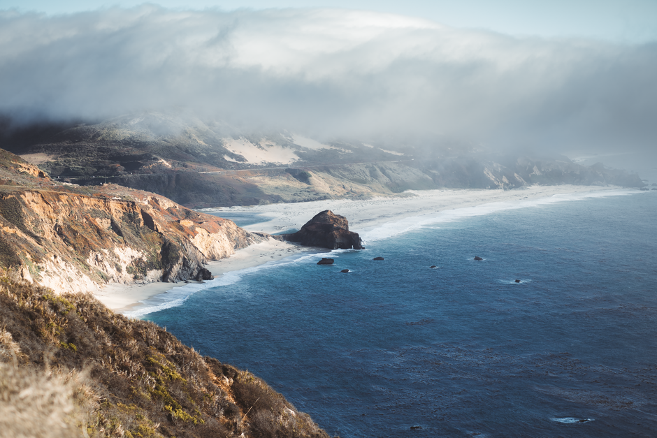
Big Sur is the wild stretch of California’s central coast where the Santa Lucia Mountains plunge straight into the Pacific, running about 90 miles (145 km) south from Carmel toward San Simeon along Highway 1, one of the most beautiful coastal drives in the world. There are no towns to speak of, just a scattering of lodges, cafés, redwood canyons, state parks and viewpoints such as Bixby Bridge and McWay Falls, with fog drifting over the cliffs. After three years of landslide closures, the full road reopened in mid-January 2026; in August and September 2026 two wildfires closed it again for a while. In early October 2026 Highway 1 is open end to end, with construction delays and some overnight closures, and Pfeiffer Big Sur State Park is still closed after the fires. Check Caltrans before you set off.
Right now in Big Sur (Big Sur Station)
- Tue 25–31°C 76–88°F Clear
- Wed 27–34°C 81–93°F Clear
- Thu 22–30°C 71–86°F Clear
- Mon 12 Oct Columbus Day
- Mon 12 Oct Indigenous Peoples' Day · regional holiday in California
Weather: MET Norway (CC BY 4.0) · Sea temperature: NOAA CoastWatch · Air quality: OpenAQ · Holidays: Nager.Date
Top tours in Big Sur
See all tours for Big Sur →
From local operators, with prices and reviews; you check availability and book on Viator, our partner. We may earn a commission at no extra cost to you. How we earn money
Big Sur at a glance
- Best for: a slow coastal drive, ocean viewpoints, redwood and coastal hikes, waterfalls, wildlife watching and quiet lodges with sea views.
- How long: one full day to drive through with stops; two or three nights to hike and slow down.
- Best time: September and October for the clearest, warmest days; April and May for green hills and wildflowers. Summer mornings are often foggy; winter storms can close the road.
- Highway 1 (as of October 4, 2026): open between Carmel and Cambria, with one-way traffic at several work zones and full overnight closures on some nights in October.
- Getting there: Carmel, at the north end, is about 120 miles (193 km) south of San Francisco; Cambria, at the south end, about 230 miles (370 km) north of Los Angeles.
- Before you go: entry rules, money, tipping and driving are in our United States travel guide.
Highway 1 in Big Sur: status in October 2026
Highway 1 through Big Sur is narrow, winding and built on unstable cliffs, so closures are part of life here. Two huge slides south of Lucia, Regent’s Slide and Paul’s Slide, cut the road for three years until Caltrans reopened the full route in mid-January 2026; visitor traffic has surged since. In August 2026 the Timber Fire and Plaskett Fire closed up to 40 miles (64 km) of the highway. Caltrans lifted the northern closure on September 3, and by early October no closure was listed: on October 4, 2026, Caltrans road information showed through traffic open, with these works to expect:
- Rocky Creek Bridge, about 15.7 miles (25 km) south of Monterey: one-way controlled traffic 24 hours a day until November 30, 2026.
- Near Nepenthe: full overnight closure from 11 p.m. on Thursday, October 8, to 5 a.m. on Friday, October 9, for drainage repairs.
- North of Point Sur Lighthouse: full overnight closures from 11 p.m. to 5 a.m., Monday, October 12, to Thursday, October 15, then one-way traffic, for an emergency embankment repair.
- Limekiln Bridge, south of Lucia: one-way flagging 8 a.m.–4 p.m. on weekdays, expected to finish by mid-November 2026.
- Mud Creek, near the southern end: one-way traffic from October 5, Monday to Saturday 7 a.m.–5 p.m., with delays of up to 10 minutes.
Conditions change quickly, especially after winter rain, which brings most of Big Sur’s landslides. Before you drive, check Caltrans QuickMap or call its road information line on 1-800-427-7623, and look for fire information from CAL FIRE. If the road is closed, the detour is inland on US 101 through Salinas and Paso Robles, which adds a long way. Fill up with gas and download offline maps before you go: services are few and far apart, and cell coverage is patchy.
Top things to see in Big Sur
Listed north to south, as you meet them driving down from Carmel. State park fees and status were checked on California State Parks pages in October 2026.
Point Lobos State Natural Reserve
Just 3 miles (5 km) south of Carmel, often called the crown jewel of the state parks, Point Lobos has cypress-topped headlands, coves of turquoise water, harbor seals, sea otters and sea lions, and, in winter, passing gray whales. Day use costs $10 per vehicle; the reserve opens 8 a.m.–7 p.m. (last entry 6:30 p.m.), and dogs are not allowed. The small lot fills early; parking on the highway shoulder and walking in is common, but be careful of traffic.
Bixby Bridge
About 13 miles (21 km) south of Carmel, the 1932 concrete arch of Bixby Creek Bridge is Big Sur’s most famous view. Use the small pull-outs at the north end, never stop on the bridge or the road, and watch for other drivers doing the same.
Point Sur and Andrew Molera State Park
The Point Sur Lighthouse crowns a volcanic rock just offshore. A little further south, about 20 miles (32 km) from Carmel, Andrew Molera State Park has trails through meadows to a wild beach at the mouth of the Big Sur River. Its day-use area was open in early October 2026 ($10 per vehicle), but the Old Coast Road and the East Molera Trail were closed after the Timber Fire.
Pfeiffer Big Sur State Park: closed
In the redwood-lined Big Sur River valley, about 26 miles (42 km) south of Carmel, this is normally the area’s main campground and hiking hub, with trails to Pfeiffer Falls and Valley View. As of October 2026 it is closed until further notice because of the impacts of the Timber and Plaskett fires. The nearby lodges, cafés and the post office cluster known as Big Sur village line the highway here.
Pfeiffer Beach and Nepenthe
Down narrow Sycamore Canyon Road, Pfeiffer Beach, on national forest land, is known for purple-tinged sand and Keyhole Rock, an arch that glows at sunset in winter; the road is unsuitable for trailers and big RVs, and a day-use fee is charged. Back on the highway, Nepenthe, a terrace restaurant founded in 1949, has one of the coast’s great views.
Julia Pfeiffer Burns State Park and McWay Falls
About 37 miles (60 km) south of Carmel, McWay Falls drops 80 ft (24 m) from a cliff toward a sandy cove, one of California’s most photographed sights, seen from a short trail. The park was partially open in early October 2026: day-use areas, restrooms and the Partington Cove trail were open ($10 per vehicle), but backcountry trails east of the highway were closed. Dogs are not allowed.
Limekiln State Park and the south coast
Two miles (3 km) south of Lucia, Limekiln has redwoods, old lime kilns and a waterfall about 100 ft (30 m) high. It was partly open in October 2026, with some campsites closed for bridge work, and takes cash only ($10 per vehicle). Further south, the coast becomes even emptier past Gorda and Ragged Point, toward the elephant seal beaches near San Simeon and Hearst Castle.
Hiking, wildlife and the coast
Hiking: with Pfeiffer Big Sur closed and inland trails shut after the fires, the best walks in fall 2026 are on the coast: Point Lobos, the bluffs and beach at Andrew Molera, Garrapata State Park’s coastal trails just south of Carmel, and Partington Cove. Stay on trails: cliffs crumble and poison oak is everywhere. See our hiking guide.
Wildlife: watch for sea otters in kelp beds, harbor seals and sea lions on the rocks, California condors soaring over the south coast, and gray whales migrating offshore in winter and spring, with humpbacks from spring to fall. Beaches: lovely to walk, but the ocean here is cold, with sneaker waves and strong currents; swimming is dangerous, and no Big Sur beach has lifeguards. See our beaches guide.
Carmel, Monterey and the road south
- Carmel-by-the-Sea: a storybook village with a white-sand beach and the historic Carmel Mission, the natural start of the drive.
- Monterey: the aquarium, Cannery Row and Fisherman’s Wharf, about 5 miles (8 km) north of Carmel; see our Monterey travel guide.
- San Simeon and Cambria: Hearst Castle on its hill, elephant seal colonies at Piedras Blancas and the pretty town of Cambria at the south end.
- Further south: Santa Barbara is about 4.5 hours from Big Sur village; see our Santa Barbara travel guide.
Nearby destinations
- Monterey60 km
- San Francisco198 km
- Santa Barbara255 km
- Yosemite National Park260 km
- Sequoia National Park261 km
- Napa Valley261 km
Getting there and driving Highway 1
From the north: San Francisco to Carmel is about 120 miles (193 km), 2.5 hours via US 101 or Highway 1 along the coast; see our San Francisco travel guide. From the south: Los Angeles to Cambria is about 230 miles (370 km) via US 101; see our Los Angeles travel guide. The nearest airport is Monterey Regional (MRY), with San Francisco and San José for more flights.
Driving tips: allow at least 4–5 hours to drive the roughly 90 miles (145 km) from Carmel to Cambria with stops, or better, stay a night. Driving south puts you on the ocean side for the best views. Use pull-outs to let faster cars pass, never stop on the road for photos, and avoid driving after dark. Some campgrounds and roads are unsuitable for long RVs. There is no public transportation along the whole coast, so you need a car or a tour.
When to go and how long to stay
Big Sur has mild temperatures all year, with wet winters and foggy summers on the coast. The table uses NOAA’s 1991–2020 normals for the Big Sur station in the Big Sur River valley, which is sunnier than the fog-prone cliffs.
| Season | Average high / low | Rain per month | What it’s like |
|---|---|---|---|
| Winter (Dec–Feb) | 59–61 °F (15–16 °C) / 42–43 °F (6 °C) | 8.6–9.5 in (218–241 mm) | Storms and landslide risk; road closures possible; quiet lodges; gray whales. |
| Spring (Mar–May) | 64–71 °F (18–21 °C) / 43–46 °F (6–8 °C) | 1.2–6.7 in (29–171 mm) | Green hills, wildflowers, waterfalls; whales heading north. |
| Summer (Jun–Aug) | 74–77 °F (23–25 °C) / 48–51 °F (9–10 °C) | Almost none | Coastal fog in the mornings, sun inland; busiest season; fire season begins. |
| Fall (Sep–Nov) | 77 °F falling to 65 °F (25–18 °C) / 50 °F falling to 45 °F (10–7 °C) | 0.1–4.2 in (3–106 mm) | Clearest skies and calmest seas; the best season. |
The station gets about 44.5 inches (1,131 mm) of rain a year, almost all from November to April, when slides are most likely. Late summer and fall are also the wildfire season; when a fire is burning, check CAL FIRE and the AirNow air-quality map for smoke.
How long to stay: 1, 2 and 3 days
1 day: leave Carmel early, walk at Point Lobos, stop at Bixby Bridge, have lunch with a view at Nepenthe, see McWay Falls, and reach Cambria by dark. 2 days: spend a night in Big Sur and add Andrew Molera’s beach, Pfeiffer Beach at sunset and Partington Cove. 3 days: add Garrapata’s coastal trails or Limekiln and finish with Hearst Castle and the elephant seals.
Where to stay in Big Sur and the room taxes
- Big Sur village and the river valley: rustic cabins, lodges and inns among the redwoods, plus restaurants.
- Clifftop resorts: a few famous luxury hotels with ocean views and very high prices.
- Camping: state park and national forest campgrounds fill months ahead in summer; with Pfeiffer Big Sur closed, choose Andrew Molera, Limekiln or forest sites, and check status first.
- Carmel, Monterey and Cambria: far more choice and better value at each end of the drive.
Big Sur has few rooms, so book early for summer and fall weekends. Room rates are quoted before tax. Big Sur is in unincorporated Monterey County, where the transient occupancy tax is 10.5% as of October 2026, according to summaries of the county’s information; Measure E on the November 3, 2026, ballot would raise it to 12.5%. Carmel, Monterey and Cambria set their own rates.
Practical tips for Big Sur
- Check the road on Caltrans QuickMap the day you drive, and again after any rain or fire news.
- Gas and food: fill up in Carmel or Cambria; the few pumps along the coast are expensive.
- Cash: some state parks, such as Limekiln, take cash only.
- Sales tax: according to the state tax agency (CDTFA), the rate in unincorporated Monterey County, including Big Sur, is 8.75% as of October 2026.
- Leave no trace: drones are banned in state parks, and fires are allowed only where permitted.
- Emergencies: call 911; coverage is patchy, so tell someone your plans.
What to pack for Big Sur
Pack layers whatever the season, as fog can drop the temperature quickly, plus a windproof jacket, sturdy shoes for dusty or muddy trails, binoculars for whales and otters, sunscreen, a refillable water bottle, snacks and some cash. Long pants help on trails lined with poison oak.
Big Sur travel FAQ
Is Highway 1 through Big Sur open?
Yes, as of October 4, 2026, from Carmel to Cambria, with one-way traffic at work zones and full overnight closures on October 8–9 near Nepenthe and October 12–15 near Point Sur. Check Caltrans QuickMap before you go.
When did Highway 1 reopen after the slides?
In mid-January 2026, after three years of repairs to Regent’s Slide and Paul’s Slide. Wildfires closed parts of it again in August and September 2026.
Is Pfeiffer Big Sur State Park open?
No. In October 2026 it is closed until further notice because of the Timber and Plaskett fires.
Can I see McWay Falls?
Julia Pfeiffer Burns State Park was partially open in October 2026, with day-use areas open for $10 per vehicle. Check the park page for the overlook trail before you go.
How long does it take to drive Big Sur?
The roughly 90 miles (145 km) from Carmel to Cambria take about 3 hours without stops; allow a full day, or stay a night.
Is it better to drive Big Sur north to south?
Driving south puts you in the lane next to the ocean, with easier access to the pull-outs and better views.
How much does it cost to visit Point Lobos?
$10 per vehicle for day use, as of October 2026; open 8 a.m.–7 p.m. with last entry at 6:30 p.m. Dogs are not allowed.
When is the best time to visit Big Sur?
September and October, for clear, warm days; spring for wildflowers. Summer is often foggy, and winter storms can close the road.
Can you swim in Big Sur?
It is not recommended: the water is cold and there are sneaker waves and strong currents, with no lifeguards. Enjoy the beaches from the sand.
Sources and last review
Researched and last reviewed on 4 October 2026. Highway 1 status, the January 2026 reopening, the fire closures and the October 2026 roadwork come from Caltrans (road information and District 5 news releases); fire sizes from CAL FIRE; park status, fees, hours and distances from California State Parks; sales tax from the California Department of Tax and Fee Administration; climate from NOAA’s 1991–2020 normals for the Big Sur station. The county hotel tax, Pfeiffer Beach details, driving distances and wildlife notes come from summaries or general sources and are flagged for checking. Road conditions change quickly, so check Caltrans before you travel. For entry rules, tipping and driving, see our United States travel guide.
Plan your trip
Partner links: TravelerCenter may earn a commission if you book, at no extra cost to you.