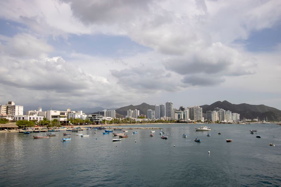
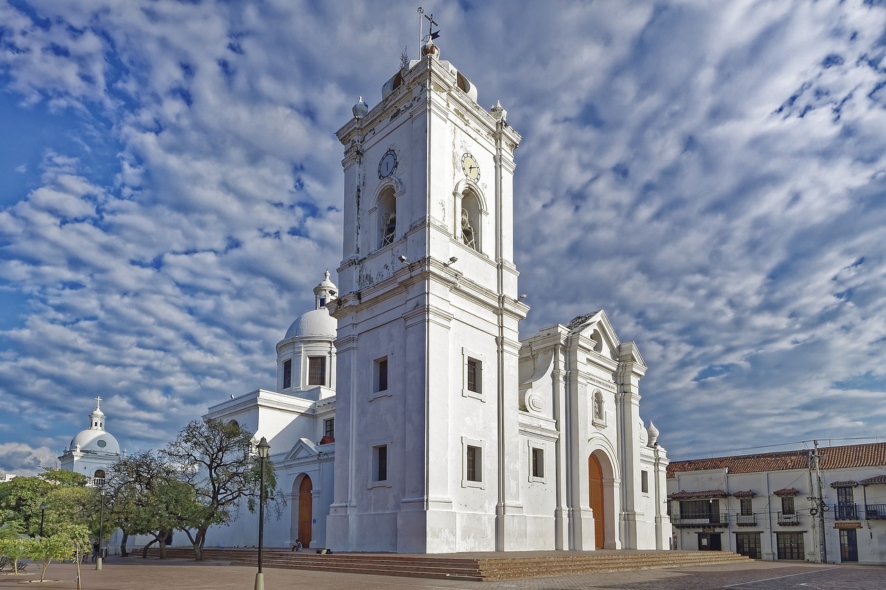
Santa Marta is one of the oldest cities in South America, founded by the Spanish in 1525 on a sheltered bay where the Sierra Nevada de Santa Marta, the world’s highest coastal mountain range, drops into the Caribbean. The city itself is a hot, lively port with a whitewashed cathedral, a seafront promenade and a compact historic center, but most travelers come for what lies around it: the beaches and rainforest of Tayrona National Natural Park, the fishing village of Taganga, the cool coffee hills of Minca, and the multi-day trek through the jungle to the Lost City (Ciudad Perdida) of the Tayrona people. It is also where Simón Bolívar, the liberator of much of South America, died in 1830. In September 2026 the city was under heightened security measures after an operation against armed groups, so check the latest local news before you travel.
Right now in Santa Marta
- Wed25–28°C77–83°F2 mm rain
- Thu26–28°C78–82°F9 mm rain
- Fri26–28°C78–82°F4 mm rain
- Mon 12 Oct Columbus Day (Día de la Raza)
Top tours in Santa Marta
See all tours for Santa Marta →
From local operators, with prices and reviews; you check availability and book on Viator, our partner. We may earn a commission at no extra cost to you. How we earn money
Santa Marta at a glance
- Best for: beaches, Tayrona, jungle trekking, diving at Taganga, birdwatching and coffee in Minca.
- How long: three to four days with Tayrona; a week or more with the Lost City trek.
- Best time: December to April, the dry season; avoid Tayrona’s closure periods.
- Getting there: Simón Bolívar Airport (SMR) is about 16 km (10 miles) south of the center, with flights from Bogotá and Medellín; Cartagena is about four to five hours by road.
- Before you go: entry rules, the Check-Mig form and money are in our Colombia travel guide.
Santa Marta’s layout: where things are
The historic center is a grid of streets between the seafront promenade (Camellón de la Bahía) and the cathedral, with Parque de los Novios at its heart for restaurants and nightlife. North over the hill is the fishing village of Taganga; south along the bay are the beach resort of El Rodadero and the hotel strip toward the airport. Inland, a mountain road climbs to the village of Minca. East along the coast road, the Troncal del Caribe (Route 90), lie the entrances to Tayrona National Natural Park and, further on, the beach town of Palomino.
Top things to see in Santa Marta
The historic center and the cathedral
The whitewashed cathedral, one of the oldest in Colombia, stands near the bay, and the streets around it are lined with colonial houses, cafés and the lively Parque de los Novios. Walk the seafront promenade at sunset, when locals come out to enjoy the breeze.
The Gold Museum (Casa de la Aduana)
ProColombia recommends the Museo del Oro Tairona in the historic center, housed in an imposing colonial customs house, with exhibits on the cultures of the Sierra Nevada de Santa Marta and their gold and ceramics. It is a good introduction before visiting Tayrona or the Lost City.
Quinta de San Pedro Alejandrino
The hacienda where Simón Bolívar spent his last days and died in 1830 is a national historic monument, according to ProColombia, with gardens, a museum and a large memorial. It is in the suburb of Mamatoco, a short taxi ride from the center.
Taganga
A former fishing village in a bay north of the city, popular for diving courses and boat trips to small beaches, according to ProColombia. It is about 15 minutes away by taxi. See our diving guide.
Other things to do in Santa Marta
- Food: try chipi chipi (small clams), fried fish, patacones, coconut rice and cocadas, according to ProColombia.
- The aquarium: ProColombia lists the city’s aquarium and sea museum, near Rodadero, as a must for marine life.
- Beaches: El Rodadero for city beach life; Playa Blanca, reached by boat from Rodadero, for clearer water. See our beaches guide.
- Birdwatching: the Sierra Nevada has many endemic bird species; Minca and the El Dorado reserve are favorite spots.
- Hiking: see our hiking guide.
Food and nightlife in Santa Marta
Santa Marta’s cooking is Caribbean, built on fish, coconut, plantain and corn. ProColombia recommends chipi chipi (small clams), fried fish, patacones, coconut rice and cocadas.
- Fish and seafood: whole fried fish with coconut rice, patacones and salad at beach restaurants in Taganga and Rodadero, and seafood stews in town.
- Chipi chipi: tiny clams cooked in garlic or in a broth, a Santa Marta favorite.
- Arepas and street snacks: arepa de huevo, carimañolas, empanadas and fresh fruit sold around the Parque de los Novios and the seafront.
- Cayeye: a mash of green banana with cheese and hogao, a typical breakfast of the Magdalena coast.
- Coffee and cacao from the Sierra: Minca’s farms grow coffee and cacao; buy beans and chocolate directly from the farms.
- Nightlife: the Parque de los Novios and the streets around it in the historic center are lined with bars and restaurants; Rodadero is livelier with Colombian families and young people.
Restaurants in the historic center range from local set lunches to modern Caribbean cooking; dinner usually starts late, after the heat of the day.
Day trips and treks from Santa Marta
Tayrona National Natural Park
The park’s main entrance at El Zaino is 32 km (20 miles) east of Santa Marta on the Troncal del Caribe, according to the national parks service, Parques Nacionales Naturales de Colombia; Bahía Concha, the closest sector, is on the city’s edge. Tayrona closes three times a year, including a closure between October and November, so check the dates. See our Tayrona National Natural Park travel guide for fees, sectors, hours and closures.
Minca
A village in the cool foothills of the Sierra Nevada, about 45 minutes by road and some 600 m (2,000 ft) above the sea, with coffee and cacao farms, waterfalls, hammock hostels and excellent birdwatching.
The Lost City trek (Ciudad Perdida)
The Lost City, or Teyuna, was built around the year 700 and was the main urban center of the ancient Tayrona civilization, with stone terraces, circular plazas, stairways and canals covering about 13 hectares, according to ProColombia. It is reached only on foot, on a guided trek of about four to six days through the jungle, with river crossings and steep climbs. Go only as part of an organized tour, according to the UK government; licensed operators in Santa Marta include guides, meals and hammock or bunk camps. The site is sacred to the Indigenous peoples of the Sierra Nevada.
Palomino
A laid-back beach town about two hours east of Santa Marta, where the Palomino River meets the sea; visitors float down the river on inner tubes. The road there passes Tayrona.
Ciénaga Grande and the banana coast
South of the city, the road to Barranquilla crosses the Ciénaga Grande de Santa Marta, a vast lagoon and mangrove system where stilt-house fishing villages such as Nueva Venecia stand in the water; boat tours run from the town of Ciénaga. Further inland is Aracataca, Gabriel García Márquez’s birthplace and the inspiration for Macondo in One Hundred Years of Solitude, with a house museum in his family home, about an hour and a half from Santa Marta.
The beaches near the city
For a beach day without going as far as Tayrona, boats from Taganga reach Playa Grande and other small coves around the bay in a few minutes, and boats from Rodadero go to Playa Blanca. The water is calmer and clearer than at the city beaches, but the coves get crowded at weekends and in the holidays.
Nearby destinations
- Tayrona National Natural Park24 km
- Cartagena170 km
Getting there and getting around
By air
Simón Bolívar International Airport (SMR) is on the coast about 16 km (10 miles) south of the center, 20–30 minutes by taxi. Flights from Bogotá take about an hour and a half, and there are flights from Medellín and other cities. See our Bogotá travel guide.
By road
Buses and door-to-door shuttles run to Cartagena (about four to five hours) and Barranquilla (about two hours), and east along the Troncal del Caribe to Tayrona, Palomino and Riohacha. See our Cartagena travel guide.
Getting around
The historic center is walkable. Use taxis called by your hotel or app-based cars, and agree fares before getting in if there is no meter. Local buses run to Taganga, Rodadero and the Tayrona entrances; jeeps and motorbike taxis go up to Minca.
Areas at a glance
- The historic center: colonial streets, the cathedral, the promenade and most restaurants and bars; best for first-time visitors.
- El Rodadero: a beach district south of the center, with high-rise hotels and apartments, popular with Colombian families.
- Bello Horizonte and Pozos Colorados: beach resorts and apartments close to the airport, far from the center.
- Taganga: a fishing village and backpacker hub with dive shops, in a bay north of the city.
- Minca: mountain lodges and hostels in the cool foothills.
- Along the Troncal del Caribe: eco-lodges near Tayrona’s entrances and in Palomino.
Getting around in detail
- Taxis and apps: the easiest way between the center, Taganga, Rodadero and the airport; agree the fare first if there is no meter.
- City buses: cheap buses run along the coast road to Taganga and Rodadero and east toward Tayrona and Palomino from the market area.
- Minca transport: shared cars and motorbike taxis leave from the center for the 45-minute climb; the last stretch to some lodges is on foot or by motorbike.
- Tours: agencies sell day trips to Tayrona, Minca and Palomino, and all Lost City treks start with transport from Santa Marta.
- Boats: boats from Taganga and Rodadero serve nearby beaches such as Playa Grande and Playa Blanca and, with the park fees paid, Tayrona’s bays.
When to go and how long to stay
Santa Marta is hot all year, often 30–33 °C (86–91 °F) by day. The dry season runs from about December to April, with strong breezes; May to November is more humid and showery, and the rains peak from September to November, when the trails to the Lost City are muddiest. The Atlantic hurricane season runs from June 1 to November 30, according to NOAA’s National Hurricane Center; direct hits are rare, but storms can bring heavy rain. Minca and the Sierra Nevada are cooler and wetter than the coast.
| Season | What it’s like | Good for |
|---|---|---|
| December–April | Dry, sunny, windy; busiest in December, January and Holy Week | Tayrona (outside the February closure), beaches |
| May–August | Hot, humid, some showers; June–July school vacations | Diving, Minca, the Lost City trek |
| September–November | Wettest months; Tayrona’s third closure falls between October and November | Lower prices, green landscapes |
Santa Marta month by month
- January: dry, windy and busy with Colombian vacations in the first half of the month.
- February: dry and breezy; Tayrona was closed February 1–15 in 2026, so check the year’s dates.
- March: dry and hot; Holy Week (March 21–28, 2027) is very busy.
- April: mostly dry, with the first showers late in the month.
- May: more humid; the first rains arrive; good prices.
- June: showers; Tayrona was closed June 1–15 in 2026; school vacations begin.
- July: often a drier spell; the Fiesta del Mar, a sea festival with a nautical parade and concerts, celebrates Caribbean culture, according to ProColombia; busy with domestic travelers.
- August: hot and humid; good for Minca and birdwatching.
- September: rain increases; quieter.
- October: one of the wettest months, with muddy Lost City trails; Tayrona’s third closure falls between October and November.
- November: rainy early, drying later; lush landscapes.
- December: the dry season returns; peak prices from mid-December.
3 days in Santa Marta
Day one, the historic center, the Gold Museum and sunset on the promenade. Day two, a full day in Tayrona, from El Zaino to Arrecifes and Cabo San Juan del Guía. Day three, Minca or Taganga.
A week around Santa Marta
Add a night inside or near Tayrona, a night in Minca for birdwatching and waterfalls, and a few days in Palomino, or swap them for the four- to six-day Lost City trek.
Where to stay in Santa Marta and the hotel taxes
- The historic center: boutique hotels and hostels close to restaurants and nightlife.
- El Rodadero and the bay: beach hotels and apartments, popular with Colombian families.
- Minca: eco-lodges and hostels in the cool hills.
- Near Tayrona and Palomino: eco-lodges, glamping and cabins along the coast road.
Prices include Colombia’s 19% value-added tax, but foreign tourists are generally exempt from it on hotel rooms when they show their passport entry stamp or migration record; ask the hotel.
Costs in Santa Marta
Santa Marta is cheaper than Cartagena. These per-person estimates are a planning guide as of October 2026, at about COP 3,273 to US$1, except the park fees:
| Item | Typical price |
|---|---|
| Hostel dorm bed in the center or Taganga | about COP 40,000–80,000 (US$12–25) |
| Mid-range hotel double room in the center | about COP 200,000–400,000 (US$60–120) |
| Eco-lodge near Tayrona or in Minca | about COP 250,000–700,000 (US$75–215) |
| Fish lunch with coconut rice | about COP 30,000–50,000 (US$9–15) |
| Taxi from the airport to the center | about COP 35,000–50,000 (US$11–15) |
| Tayrona entrance for non-resident foreigners | COP 81,000 low season, COP 96,500 high season (US$25–29), plus insurance |
| Lost City trek, 4–6 days, all-inclusive | about COP 1,800,000–2,600,000 (US$550–795) |
Our estimates, not official statistics, except the Tayrona fees, which come from the national parks service.
Practical tips for Santa Marta
- Security in 2026: in September 2026 Santa Marta was under heightened security measures after a major operation against armed groups, with damage to vehicles and businesses, closures and disruption to transport, including on Route 90 (the Troncal del Caribe), which links the city with Tayrona, Palomino and Riohacha, according to the UK government. The national parks service said on September 25, 2026, that Tayrona remained open, while field work in the Sierra Nevada de Santa Marta National Natural Park was suspended. Follow local news and instructions from the authorities, and ask your hotel or tour operator about road conditions before you travel.
- Street crime: as in other Colombian cities, keep valuables out of sight, use called taxis and avoid empty beaches and streets after dark. Emergencies: 123.
- Heat: drink plenty of water and avoid the midday sun.
- Water: drink bottled or filtered water.
- Money: withdraw cash in the city before heading to Tayrona, Minca or Palomino, where ATMs are scarce.
What to pack for Santa Marta
Bring light clothes, swimwear, sandals and sturdy hiking shoes for Tayrona or the Lost City, plus a hat, reef-safe sunscreen, strong insect repellent, a dry bag, a headlamp and a light rain jacket for Minca. For the Lost City trek, pack quick-drying clothes, a small backpack, blister care and a refillable water bottle. Plugs are the US type.
Santa Marta travel FAQ
How do I get from Santa Marta to Tayrona?
By bus, taxi or tour along the Troncal del Caribe to the El Zaino entrance, 32 km (20 miles) east of the city, according to the national parks service.
How long is the Lost City trek?
Usually four to six days on foot with a licensed guide, from villages in the foothills of the Sierra Nevada. Tours leave from Santa Marta.
When is the best time to visit Santa Marta?
December to April, the dry season. Check Tayrona’s closure dates, which in 2026 included February 1–15 and June 1–15.
What is there to do in Santa Marta itself?
The historic center, the cathedral, the Gold Museum, the Quinta de San Pedro Alejandrino and sunset on the seafront promenade.
Is Santa Marta safe in 2026?
In September 2026 the city was under heightened security measures after an operation against armed groups, with transport disruption on the coast road. Check local news and ask your hotel or tour operator before traveling.
Where should I stay in Santa Marta?
The historic center for restaurants and nightlife, Rodadero for beaches, Minca for the hills, or lodges near Tayrona and Palomino.
How far is Santa Marta from Cartagena?
About four to five hours by bus or shuttle, via Barranquilla.
How much is the Lost City trek?
By our estimates, an all-inclusive four- to six-day trek with a licensed operator costs about COP 1,800,000–2,600,000 (US$550–795), including guides, meals, camps and transport.
Is Minca worth visiting?
Yes, for cooler air, coffee and cacao farms, waterfalls and some of Colombia’s best birdwatching, about 45 minutes from the city.
How do I get around Santa Marta?
By taxi or app for most trips, by local bus along the coast to Taganga, Rodadero and Tayrona, and by shared car or motorbike taxi to Minca.
Plan your trip
Partner links: TravelerCenter may earn a commission if you book, at no extra cost to you.
🇪🇸 Useful Spanish phrases for Santa Marta
All 38 Spanish phrases: restaurant, hotel, emergencies, romance (printable) →
Sources · last reviewed 4 October 2026
Researched and last reviewed on 4 October 2026. The Gold Museum, the Quinta de San Pedro Alejandrino, Taganga, the aquarium, local dishes and the Lost City’s age, size and features: ProColombia; the El Zaino entrance distance, Tayrona’s closures and its status on September 25, 2026: Parques Nacionales Naturales de Colombia; the September 2026 security situation, the organized-tour rule for the Lost City and the emergency number: the UK government; the hurricane season: NOAA’s National Hurricane Center. The founding date, Bolívar’s death in 1830, the airport distance, travel times, Minca’s altitude, the trek length, the weather table and the hotel tax exemption come from secondary sources or general knowledge and are flagged for checking. The food, neighborhood, getting-around, month-by-month and cost sections draw on secondary sources, general knowledge and our own estimates, except where an official source is named, and are flagged for checking. Prices and rules change, so check before you go. For entry rules and money, see our Colombia travel guide.
Data: Weather: MET Norway (CC BY 4.0) · Sea temperature: NOAA CoastWatch · Rates: ECB · Holidays: Nager.Date · Costs: World Bank ICP and price levels · Wikidata (CC0)