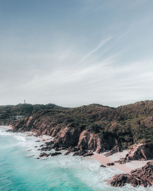
Byron Bay, on the far north coast of New South Wales, is one of Australia’s most famous beach towns: a former whaling and meat-works port turned surf, wellness and creative hub, with long golden beaches, a lighthouse on the mainland’s most easterly point and green hinterland hills of rainforest and small villages. It is on the country of the Arakwal people of the Bundjalung nation, whose name for the cape is Walgun. The town itself is small, with fewer than 10,000 residents, but it draws huge numbers of visitors to its cafes, surf breaks, markets and festivals, and it can feel crowded in summer and school holidays. Mornings start with the walk up to Cape Byron Lighthouse, dolphins in the waves and, from May to November, humpback whales offshore; days drift between Main Beach, The Pass and Wategos; and evenings fill the bars and restaurants of Jonson Street. Byron Bay is about 2 hours south of Brisbane and less than an hour from the Gold Coast, so it pairs easily with a Queensland trip. It has a warm, humid subtropical climate, with hot, wet summers and mild, sunny winters.
Right now in Byron Bay (Cape Byron)
- Wed18–23°C65–73°F6 mm rain
- Thu15–20°C59–67°F4 mm rain
- Fri16–23°C60–74°FPartly cloudy
Top tours in Byron Bay
See all tours for Byron Bay →
From local operators, with prices and reviews; you check availability and book on Viator, our partner. We may earn a commission at no extra cost to you. How we earn money
Byron Bay at a glance
- Best months: March to May and September to November for warm, settled weather and fewer crowds; June to November for whale watching. December and January are hot, humid and very busy.
- Time needed: two or three days for the beaches, lighthouse walk and town; four or five days to add the hinterland villages and waterfalls.
- Getting there: fly to Ballina Byron Gateway Airport (about 30 minutes away) or Gold Coast Airport (about 45 to 50 minutes), or drive about 2 hours from Brisbane.
- Costs (as of October 2026): parking at the Cape Byron Lighthouse costs $10 per vehicle per hour, with a 1-hour limit; walking up is free.
- Before you go: entry rules (ETA, eVisitor or visa), biosecurity and money are covered in our Australia travel guide.
Byron Bay areas and who each one suits
Town center and Main Beach
The compact center around Jonson Street, Lawson Street and Bay Lane has cafes, restaurants, bars, surf and fashion shops and most backpacker hostels. Main Beach and Clarkes Beach are a short walk away. Stay here to walk everywhere, but expect noise at night.
Wategos and The Pass
Below the lighthouse, Wategos Beach is a sheltered, north-facing bay with luxury stays, and The Pass is a famous longboard surf break. They’re the most exclusive and peaceful parts of Byron.
Suffolk Park and Tallow Beach
South of the cape, Suffolk Park is a quieter residential area beside the long, wild Tallow Beach and Arakwal National Park. It suits families and longer stays.
The hinterland: Bangalow, Mullumbimby and beyond
Inland, the hills are dotted with heritage villages, farms, rainforest retreats and luxury hideaways. Bangalow, about 15 minutes away, has a historic main street and good restaurants.
Top things to see in Byron Bay
Cape Byron Lighthouse and the Walgun Cape Byron walking track
Built at the turn of the 20th century on the most easterly point of the Australian mainland, Cape Byron Lighthouse was run by resident keepers until 1989; its automated light still shines over Cape Byron Marine Park. The lighthouse lawn is the best spot in Byron for views over the coast and hinterland, and for spotting turtles, dolphins and, in season, humpback whales. Guided tours of the lighthouse and the Maritime Museum run on limited days and times. The Walgun Cape Byron walking track is a 3.7 km (2.3-mile) loop, grade 3, taking one to three hours, through rainforest, along beaches and grasslands and across clifftops to the lighthouse. Start early for sunrise from the easternmost point, and bring water, a hat and binoculars.
Wategos, The Pass and Main Beach
Byron’s beaches face north and east, so you can find a sheltered spot in most winds. Main Beach is the town beach, patrolled in season; The Pass is best for watching longboarders; Wategos is a postcard-pretty cove. Tallow Beach, south of the cape, is long and wild. The Pass also protects an Aboriginal midden, first recorded in 1980, now cared for with the local Aboriginal community.
Julian Rocks
About 2.5 km (1.5 miles) offshore, Julian Rocks is a marine reserve where warm and cool currents meet, making it one of the best dive and snorkel sites on the New South Wales coast. Turtles, rays and gray nurse sharks are common, and leopard sharks gather in summer. Dive shops run trips from the beach.
Sea kayaking and surfing
Guided sea kayak tours paddle out from Main Beach to look for dolphins and turtles, and surf schools teach beginners on the gentle breaks around Clarkes Beach and The Pass.
Markets
Byron’s markets sell local produce, crafts and fashion: the weekly farmers market in town, and monthly community markets in Byron Bay, Bangalow and Mullumbimby. Check dates before you go.
From whaling town to surf town
Byron’s modern history is short and colorful. Timber cutters arrived in the 19th century to log the red cedar of the hinterland, the jetty shipped dairy produce, and from 1954 to 1962 a whaling station operated on the bay, processing humpbacks hunted on the migration route that now draws whale watchers. The meat works and sand mining closed in the 1970s and 1980s, just as surfers, discovering the long right-hand waves at The Pass, and alternative-lifestyle communities from the hinterland’s Aquarius Festival in nearby Nimbin began to shape the town’s laid-back reputation. Today, wellness, creative industries and tourism dominate, and housing costs have soared.
Arakwal culture
One of Australia’s first Indigenous Land Use Agreements, between the Arakwal people and the NSW Government, led to the creation in 2001 of Arakwal National Park, which they jointly manage. Their connection to Walgun (Cape Byron) and the coast is told in cultural signage along the walking track and through Aboriginal-guided walks and experiences in the area. Respect midden sites and signs asking visitors to keep off sensitive areas.
Byron on a budget
Byron is expensive, but plenty of its best experiences are free: sunrise at the cape (walk up instead of paying for parking), swimming and surfing at the beaches, the walking track, Arakwal National Park, people-watching on Main Beach at sunset and free live music in some bars. Stay in a hostel, a cheaper motel in Suffolk Park, or in Ballina or Brunswick Heads, and visit outside summer and school holidays, when prices drop sharply.
Other things to do in Byron Bay
- Whale watching: humpbacks migrate past the cape from about May to November; boat tours run in season, or watch from the lighthouse.
- Wellness: yoga studios, spas and retreats are part of Byron’s identity.
- Hang gliding and skydiving: tandem flights launch from the cape area and beaches.
- Arakwal National Park: walks through coastal heath and banksia woodland behind Tallow Beach.
- Live music: pubs and bars host gigs most nights, especially on weekends.
Food and drink
Byron’s food scene leans healthy and local: acai bowls, smoothies and specialty coffee by day, and seafood, modern Australian and Asian dishes at night, with produce from hinterland farms and macadamia, coffee and craft beer and gin producers nearby. Book ahead for popular restaurants in summer. Tipping is optional.
Day trips from Byron Bay
Bangalow and the hinterland villages
Bangalow’s tree-lined main street has cafes, shops and a monthly market. Further inland, Federal, Clunes and Mullumbimby are small villages with weekend markets and farm cafes.
Nightcap National Park and Minyon Falls
About 45 minutes inland, the World Heritage-listed rainforests of Nightcap National Park include Minyon Falls, which drops about 100 meters (330 feet) from a rhyolite cliff, and Protestors Falls.
Brunswick Heads and Lennox Head
North of Byron, Brunswick Heads is a laid-back fishing town on a river with calm swimming. South, Lennox Head has a famous surf point and a cliff-top lookout popular with hang gliders.
Gold Coast and Tweed
The Gold Coast is about 45 minutes to an hour north. On the way, the Tweed region has Cabarita Beach and the rainforest around Wollumbin.
Nearby destinations
- Gold Coast73 km
- Brisbane143 km
- Sunshine Coast228 km
Getting there and getting around
Flights
Ballina Byron Gateway Airport (BNK), about 30 minutes south, has flights from Sydney and Melbourne. Gold Coast Airport (OOL), about 45 to 50 minutes north, has more domestic flights and some international services. Shuttle buses meet many flights.
By road
From Brisbane, drive about 2 hours south on the Pacific Motorway. From Sydney, it’s about 8 to 9 hours’ drive, or an overnight trip by coach or train and coach. Long-distance coaches stop in town.
Getting around
The town center and nearby beaches are walkable, and cycling is popular. Local buses link Byron with Ballina, Mullumbimby and the hinterland. Parking in town and at beaches is limited and paid in many areas. A car is useful for the hinterland and waterfalls.
Parking at the cape
At the Walgun Cape Byron State Conservation Area, park fees apply. At the lighthouse lawn and information center, parking is $10 per vehicle per hour ($4 for motorcycles), with a maximum of one hour per vehicle per day, including for NSW National Parks annual pass holders. At Bawaii rest area, Cosy Corner and The Pass, parking costs $5 per vehicle or motorcycle per hour. Pay machines take tap-and-pay cards and phones. The conservation area is open all hours but may close in poor weather or fire danger, and the Walgun Cape Byron Information Centre is open 9:30 a.m. to 4:30 p.m. daily.
When to go and how long to stay
Byron Bay has a humid subtropical climate. Summer (December to February) is hot and humid, with highs around 27–28 °C (80–82 °F), storms and the heaviest crowds. Autumn (March to May) is warm, and rain can be heavy into early winter. Winter (June to August) is mild and sunny, with highs around 19–20 °C (66–68 °F), cool nights and whales offshore. Spring (September to November) follows the driest months of August and September and is one of the best times to visit.
| Month | Average high | Average low | Rain | Rain days (≥1 mm) |
|---|---|---|---|---|
| Jan | 28 °C (82 °F) | 21 °C (70 °F) | 156 mm (6.1 in) | 10 |
| Feb | 28 °C (82 °F) | 21 °C (70 °F) | 190 mm (7.5 in) | 12 |
| Mar | 27 °C (80 °F) | 20 °C (68 °F) | 150 mm (5.9 in) | 12 |
| Apr | 24 °C (75 °F) | 18 °C (64 °F) | 161 mm (6.4 in) | 12 |
| May | 21 °C (71 °F) | 15 °C (59 °F) | 95 mm (3.7 in) | 10 |
| Jun | 19 °C (67 °F) | 13 °C (56 °F) | 170 mm (6.7 in) | 11 |
| Jul | 19 °C (66 °F) | 12 °C (54 °F) | 83 mm (3.3 in) | 8 |
| Aug | 20 °C (68 °F) | 13 °C (56 °F) | 70 mm (2.8 in) | 5 |
| Sep | 22 °C (72 °F) | 15 °C (60 °F) | 50 mm (2.0 in) | 6 |
| Oct | 24 °C (75 °F) | 17 °C (63 °F) | 90 mm (3.5 in) | 9 |
| Nov | 25 °C (78 °F) | 19 °C (65 °F) | 86 mm (3.4 in) | 8 |
| Dec | 27 °C (80 °F) | 20 °C (68 °F) | 128 mm (5.0 in) | 10 |
| Year | 24 °C (74 °F) | 17 °C (63 °F) | 1,429 mm (56 in) | 113 |
Figures are the Bureau of Meteorology’s 1991–2020 statistics for Byron Bay (Cape Byron AWS), on the cape (18 years of records, 2002–2020).
Events worth planning around
- Whale migration (about May to November): humpbacks pass the cape on their way north and south.
- Byron Writers Festival (August).
- Schoolies (late November): school leavers’ celebrations fill the town; book well ahead or avoid.
- New Year’s Eve: the town is extremely busy, with alcohol-free zones.
Dates vary; check the organizers’ websites.
How long to stay: 2, 3 and 5 days
- Two days: the lighthouse walk at sunrise, Wategos and The Pass, Main Beach and dinner in town.
- Three days: add a sea kayak or Julian Rocks snorkel, and Bangalow.
- Five days: add Minyon Falls, Brunswick Heads and Lennox Head, or a day on the Gold Coast.
Where to stay in Byron Bay
- Town center: hostels, motels and boutique hotels within walking distance of beaches.
- Wategos and the cape: luxury villas and boutique retreats.
- Suffolk Park and Belongil: beach houses, apartments and resorts.
- Hinterland: farm stays, rainforest cabins and luxury retreats.
Prices are among the highest of any Australian beach town, and minimum stays apply in peak periods; book months ahead for summer.
Typical costs in Byron Bay
| Item (as of October 2026) | Australian dollars | About US dollars |
|---|---|---|
| — | — | — |
| Lighthouse parking, per vehicle per hour | $10 | $6.90 |
| Parking at The Pass, Cosy Corner or Bawaii, per hour | $5 | $3.45 |
| Sea kayak tour with dolphins | about $90–110 | about $60–75 |
| Snorkel trip to Julian Rocks | about $80–120 | about $55–85 |
| Surf lesson (group, 3 hours) | about $80–100 | about $55–70 |
| Mid-range hotel or motel room, per night | about $250–450 | about $170–310 |
Cape Byron parking fees are official NSW National Parks prices; other prices are typical ranges, not official prices. Conversions use about US$0.69 to A$1.
Safety in Byron Bay
- Rips and surf: Byron’s beaches often have strong rips. Swim at patrolled beaches between the red and yellow flags, and don’t swim alone or after drinking.
- Sharks: sharks are present along the coast; NSW uses tagged-shark listening stations and drumlines. Check SharkSmart alerts, avoid swimming at dawn, dusk and in murky water, and follow lifeguards’ directions.
- Cliffs: stay on the track and away from cliff edges around the cape.
- Bushfire season: roughly August to March in northern NSW. Check NSW Rural Fire Service fire danger ratings, especially in the hinterland, and obey total fire bans.
- Floods and storms: the Northern Rivers region is prone to flooding after heavy rain; never drive through floodwater.
- Sun: UV is strong all year; use sunscreen and a hat.
- Emergencies: call 000 (112 also works from mobile phones).
Practical tips for Byron Bay
- Time zone: Australian Eastern Time with daylight saving (4 October 2026 to 4 April 2027), so in summer Byron is one hour ahead of the Gold Coast and Brisbane, which don’t change their clocks. Check flight and tour times.
- Book ahead: accommodation and restaurants fill in summer, Easter and school holidays.
- Parking: allow time to find a spot near beaches, or walk and cycle.
- Plugs and money: type I plugs at 230 V; cards accepted almost everywhere.
- Alcohol-free zones: drinking in public is banned in parts of the town center and on Main Beach; fines apply.
- Sunrise timing: in midsummer the sun rises at the cape at about 5:45 a.m. (daylight saving time), so set an early alarm; in midwinter it rises at about 6:35 a.m.
What to pack for Byron Bay
Pack swimwear, a rash vest for surfing, a broad-brimmed hat, reef-safe sunscreen, sunglasses, sandals and good walking shoes for the cape. In winter, add a light jacket and sweater for cool evenings.
Byron Bay travel FAQ
How long is the Cape Byron walk?
The Walgun Cape Byron walking track is a 3.7 km loop that takes one to three hours, through rainforest, beaches and clifftops to the lighthouse.
How much is parking at Byron Bay lighthouse?
$10 per vehicle per hour, with a maximum of one hour per vehicle per day. Walking up from town is free.
When can you see whales in Byron Bay?
From about May to November, when humpback whales migrate past the cape.
How do I get to Byron Bay?
Fly to Ballina Byron (about 30 minutes away) or the Gold Coast (about 45 to 50 minutes), or drive about 2 hours from Brisbane.
Is Byron Bay the most easterly point of Australia?
Cape Byron is the most easterly point of the Australian mainland, marked by the lighthouse.
What is the best time to visit Byron Bay?
March to May and September to November for warm weather and fewer crowds.
Is Byron Bay in the same time zone as the Gold Coast?
Not in summer. Byron Bay follows NSW daylight saving, so from October to April it is one hour ahead of Queensland.
Is Byron Bay safe for swimming?
Yes, at patrolled beaches between the flags. Rips are common, so follow lifeguards’ directions.
Where can I snorkel in Byron Bay?
At Julian Rocks marine reserve, on a boat trip from Main Beach, for turtles, rays and sharks.
Is Byron Bay a good day trip from Brisbane or the Gold Coast?
Yes, but staying a night or two lets you see the sunrise from the cape and explore the hinterland.
Plan your trip
Partner links: TravelerCenter may earn a commission if you book, at no extra cost to you.
Sources · last reviewed 5 October 2026
Researched and last reviewed on 5 October 2026. Cape Byron Lighthouse history, tours, the walking track, beaches, the midden, whale season, park fees, the information center’s hours and the conservation area’s opening come from NSW National Parks and Wildlife Service; daylight saving dates from the NSW Government; climate from the Bureau of Meteorology’s 1991–2020 statistics for Byron Bay (Cape Byron AWS); population and coordinates from Wikidata. Julian Rocks, flights, drive times, markets, festivals, Minyon Falls, shark measures, bushfire season and typical prices are general references and flagged for checking. For entry rules, biosecurity and money, see our Australia travel guide.
Data: Weather: MET Norway (CC BY 4.0) · Sea temperature: NOAA CoastWatch · Rates: ECB · Costs: World Bank ICP and price levels · Wikidata (CC0)