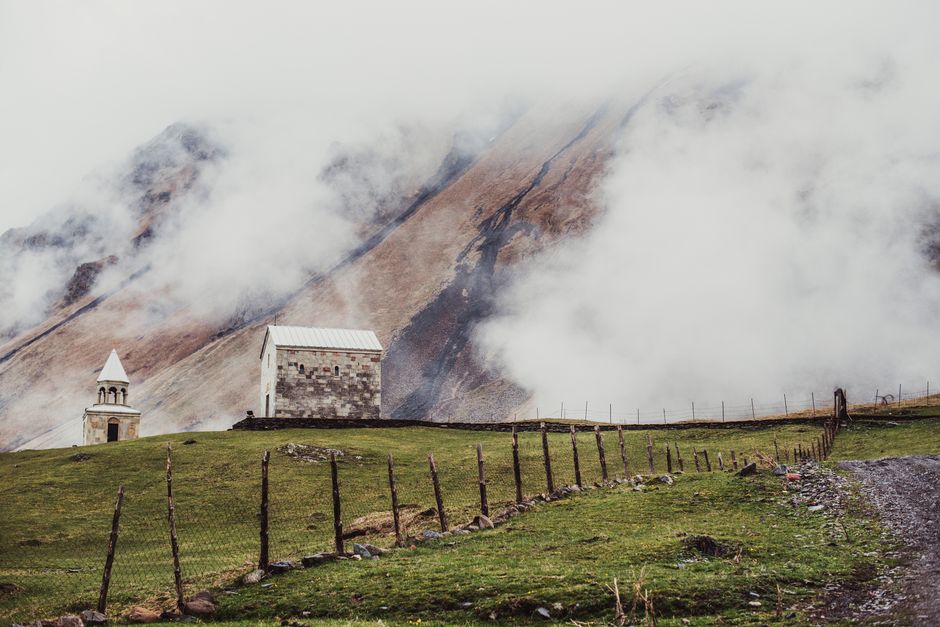
Kazbegi is Georgia’s most famous mountain view: a small stone church on a grassy ridge, and behind it the white cone of Mount Kazbek, more than 5,000 m high. The base is Stepantsminda, a village of guesthouses about 150 km north of Tbilisi at the end of the spectacular Georgian Military Highway, still widely known by its Soviet-era name, Kazbegi. From here you can walk or ride up to Gergeti Trinity Church, hike towards the Gergeti glacier, see the waterfalls of the Dariali gorge, and explore the high valleys of Juta and Truso in Kazbegi National Park. It is just 11 km from the Russian border, and the Truso valley leads towards South Ossetia, so read the safety notes below. Give it two or three nights, ideally between June and early October, when the high trails are clear of snow.
Right now in Kazbegi (Stepantsminda)
- Wed 5–11°C 41–51°F 1 mm Partly cloudy
- Thu 6–13°C 42–56°F 1 mm Mostly clear
- Fri 5–10°C 42–49°F 3 mm Showers
Weather: MET Norway (CC BY 4.0)
Top tours in Kazbegi
See all tours for Kazbegi →
From local operators, with prices and reviews; you check availability and book on Viator, our partner. We may earn a commission at no extra cost to you. How we earn money
Kazbegi at a glance
- Best months: June to September for hiking; late September and early October for golden colours and fewer people; December to March for snow and quiet, if the road is open.
- Days needed: a long day trip from Tbilisi is possible, but 2–3 nights let you hike.
- Getting there: about three hours by road from Tbilisi over the Jvari Pass (2,379 m), by minibus from Didube, shared taxi, driver or tour.
- Altitude: Stepantsminda sits at about 1,750 m and Gergeti Trinity Church at 2,170 m; nights are cold even in August.
- Safety: stay out of the area next to the South Ossetia boundary line at the head of the Truso valley, and do not go beyond Georgian customs at Dariali unless you are entering Russia.
How Kazbegi works: the town, the valley and the national park
Stepantsminda, a village of about 1,900 people, lies in the deep valley of the Tergi (Terek) river, which flows north through the Dariali gorge into Russia. Across the river, the village of Gergeti climbs the slope towards the church and, far above, the glaciers of Mount Kazbek (about 5,054 m, according to the Georgian National Tourism Administration), an extinct volcano and one of the highest peaks of the Caucasus. Kazbegi National Park, set up in 1976 and covering about 78,500 ha, protects the high country around the town in several blocks, including Kazbek’s slopes, the side valleys and the Truso gorge; only about a third of it is forest, the rest being alpine meadows, rock and ice. The park administration is in Stepantsminda. The Kazbegi municipality’s main road is the Military Highway, which brings everyone in and leads on to the Russian border at Upper Lars.
Tickets and fees (as of October 2026)
There is no ticket for Gergeti Trinity Church, the town or the main trails, as far as we could find from the Agency of Protected Areas and travel guides. You pay for transport and services instead: a 4×4 ride up to the church is reported at about 40 lari return per vehicle, guided treks and horse rides are priced locally, and the Kobi–Gudauri cable car and ski lifts have their own fares. Overnight stays at the mountain huts on Kazbek are paid. If you plan glacier trekking or a climb of Kazbek, go with a licensed guide and register your route; ask at the park’s visitor service in Stepantsminda.
Gergeti Trinity Church
The 14th-century Gergeti Trinity Church (Tsminda Sameba), with its separate bell tower, stands alone on a ridge at 2,170 m, about 6 km from Stepantsminda by road. It is the image on half the postcards in Georgia, and it is even better in person, especially early in the morning before the 4x4s arrive, or in late afternoon light. Walk up by the steep footpath through Gergeti village, which takes most fit walkers about an hour to an hour and a half from the town centre, or take a 4×4 along the winding road. It is an active church: dress modestly, with shoulders and knees covered (women usually also cover their hair; wraps are often lent at the door), keep your voice down, and do not take photos inside. The church’s feast, Gergetoba, falls on 16 July.
Hiking around Kazbegi
- Gergeti glacier viewpoint: beyond the church, a long, steady climb over the Sabertse pass leads to a viewpoint above the Gergeti glacier; a full day from Stepantsminda, rising well above 3,000 m. Go early and turn back if the weather closes in.
- Juta and the Chaukhi massif: Juta, at about 2,200 m the highest village in the municipality, sits below the jagged Chaukhi peaks (up to 3,688 m). The Agency of Protected Areas puts it 24 km from Stepantsminda, 8 km paved to Sno and 16 km of gravel. An easy walk leads up the valley to Fifth Season huts and lakes; experienced trekkers cross the Chaukhi pass to Roshka, a long day. The road usually opens in late May; in 2026 snow kept it closed until June.
- Gveleti waterfall: an easy outing 7 km from Stepantsminda, near the village of Gveleti in the Dariali gorge, with the last 700 m on foot.
- Truso valley: a broad, wild valley of mineral springs, travertine terraces and abandoned villages, 25 km from Kobi, which is 20 km south of Stepantsminda. The track is usually passable only from about June to October by 4×4, or you can walk. Read the safety note below before you go.
- Mount Kazbek: a serious glacier climb with crevasses and altitude, usually from the Meteo station hut at about 3,650 m, for experienced mountaineers with a guide in July and August.
Mountain rescue and medical care are limited, and altitude sickness is a risk on Kazbek. Carry water, warm and waterproof layers and a map, start early to avoid afternoon storms, and tell your guesthouse where you are going. See our hiking guide.
The Truso valley and the South Ossetia boundary line
The upper Truso valley runs up to the administrative boundary line with South Ossetia, a region controlled by Russian-backed authorities. The areas immediately next to the boundary line are restricted. The line is unmarked on the ground, and people who stray across have been detained. Visitors usually turn round at the Georgian police post near the ruined Zakagori fortress, at the head of the valley; do not go beyond it, check with the park office or your guesthouse before you go, and carry your passport. The lower and middle valley, with its springs and travertines, is the part most people visit.
The Georgian Military Highway and the Jvari Pass
The road from Tbilisi to Stepantsminda is part of the historic Georgian Military Highway to Vladikavkaz in Russia. Highlights on the way include the fortress church of Ananuri on the Zhinvali reservoir, the ski resort of Gudauri, the colourful mosaic of the Russia–Georgia Friendship Monument overlooking the Devil’s Valley, and the Jvari Pass at 2,379 m, about 30 km before Stepantsminda. Below the pass, a cable car links Kobi with Gudauri.
The upper road is prone to landslides, heavy snow and avalanches. Georgia’s Roads Department closes the Gudauri–Kobi section to all vehicles when the avalanche risk is high, sometimes for days, as in February 2026, and restricts lorries and trailers in ice and snow. A new road between Kvesheti and Kobi, with a 9 km tunnel and a 166 m-high bridge, will bypass the pass and cut the journey from Tbilisi to about 1.5 hours, but the Roads Department said in August 2026 that it expects it to be finished by the end of 2028. In winter, check the Roads Department’s restriction notices before setting off and allow a spare day.
Dariali gorge and the Russian border
North of Stepantsminda, the Tergi cuts through the dramatic granite Dariali gorge for about 11 km to the border at Upper Lars. You can drive or walk to the Gveleti waterfall and to the large modern Dariali monastery near the border. The ruined medieval Dariali fortress is beyond Georgian customs, so you cannot reach it without passing through the border post. The crossing to Russia (Verkhny Lars) is open but closes often in bad weather, and long queues of lorries are common. On 25 September 2026, the Roads Department closed the Dariali section for a few hours for safety reasons, a reminder that rockfalls happen here too.
Nearby destinations
- Tbilisi105 km
- Sheki265 km
- Lake Sevan268 km
- Batumi272 km
- Yerevan276 km
Getting there and getting around
By minibus
Minibuses (marshrutkas) leave from Didube bus station in Tbilisi (Didube metro). Travel guides checked in September 2026 report a fare of about 20 lari after a rise in spring 2026, a journey of two and a half to three hours, and around eleven departures between 08:00 and 19:00 in summer, fewer in winter. They drop you near the main square in Stepantsminda. Shared taxis also leave from Didube once full.
By car, driver or tour
Driving yourself or hiring a driver for the day lets you stop at Ananuri, the Friendship Monument and the pass. The road is good asphalt but busy with lorries heading to Russia, and the bends above Gudauri need care. In winter, use a 4×4 with winter tyres, or leave the driving to locals. Day tours from Tbilisi run all year, weather permitting, but a night in Stepantsminda is far more rewarding.
Around Kazbegi
4×4 taxis wait in the main square to take you to Gergeti Trinity Church, Juta, Truso and the waterfalls; agree the price, waiting time and route first. You can walk to the church and to Gveleti from town. There is no public transport to the side valleys.
Around Kazbegi: Ananuri, Gudauri and Pasanauri
On the way, Ananuri is a 17th-century fortress complex with two churches above the turquoise Zhinvali reservoir, about 70 km from Tbilisi. Pasanauri is a good stop for khinkali, which locals say were invented in these valleys. Gudauri, at about 2,200 m, is Georgia’s biggest ski resort in winter and a paragliding base in summer. From Stepantsminda, Sno village, on the way to Juta, has giant stone heads carved by a local artist and a ruined fortress.
When to go and how long to stay
Kazbegi has a mountain climate: short, mild summers with frequent afternoon storms, and long, snowy winters. Georgia’s official 1991–2020 climate normals have no station in Stepantsminda; the nearest, Pasanauri on the Military Highway at 1,080 m, records July highs of about 26–27 °C and January lows of about −6 °C. Stepantsminda is about 700 m higher, and modelled climate data put its July highs at about 20 °C and January lows at about −11 °C. Expect frost on many nights from October to April.
| Season | In Stepantsminda | What it’s like |
|---|---|---|
| Spring (Mar–May) | highs 3–14 °C, snow lingering high up | Muddy, with high valleys snowbound; the wettest weeks start in May. |
| Summer (Jun–Aug) | highs 17–20 °C, lows 5–8 °C | Hiking season; storms most afternoons in June and July. |
| Autumn (Sep–Nov) | highs 16 °C falling to 4 °C | Clear, golden days in September and October; first snow by November. |
| Winter (Dec–Feb) | highs −2 to 0 °C, lows −9 to −11 °C | Snowy and quiet; the road can close; ski at Gudauri. |
Stepantsminda figures are modelled estimates, not station records, so treat them as a guide. July and August are the busiest months; Gergeti is crowded by midday.
Kazbegi in one day
Leave Tbilisi early, stop briefly at Ananuri and the Friendship Monument, ride a 4×4 or walk up to Gergeti Trinity Church, and visit the Gveleti waterfall before heading back. It is a long day of five to six hours on the road.
Two or three days
Day 1: drive up, settle in, and walk to Gergeti for sunset. Day 2: Juta and the Chaukhi valley, or the hike towards the Gergeti glacier. Day 3: the Truso valley’s lower and middle sections, or Dariali and Gveleti, before heading back to Tbilisi.
Where to stay in Kazbegi
- Stepantsminda: family guesthouses, hostels and small hotels, close to minibuses, shops and cafés.
- Gergeti village: guesthouses on the slope across the river with views of the church and Kazbek; quieter.
- Design hotel: a well-known modern hotel above town looks straight at Kazbek; book ahead.
- Juta: simple summer huts and guesthouses for trekkers.
Practical tips for Kazbegi
- Cash: carry lari; cards are not accepted everywhere, and there are few cash machines.
- Weather: clouds often hide Kazbek by late morning; go up to Gergeti early.
- Road: in winter, check the Roads Department’s notices for the Gudauri–Kobi section before leaving Tbilisi.
- Borders: do not wander towards South Ossetia from Truso, and do not go past Georgian customs at Dariali unless you mean to enter Russia.
- Museum: the Alexander Kazbegi house museum in Stepantsminda was reported closed in July 2026; check locally.
- Emergencies: call 112.
What to pack for Kazbegi
Pack hiking shoes with good grip, a warm fleece and a hat even in summer, a rain jacket for afternoon storms, sunglasses and high-factor sunscreen for the strong mountain sun, a refillable bottle and snacks. Bring a scarf or wrap and long trousers or a skirt for Gergeti, cash, and your passport. In winter, add proper boots, gloves and thermal layers. Plugs are the European two-pin type; see our travel adapters guide.
Kazbegi travel FAQ
Is Kazbegi the same as Stepantsminda?
Yes. The village was officially renamed Stepantsminda in 2006, but most people still call it Kazbegi, after the municipality, the national park and Mount Kazbek.
How do I get from Tbilisi to Kazbegi?
By minibus from Didube station, reported at about 20 lari and two and a half to three hours, or by shared taxi, private driver or tour. The road crosses the Jvari Pass.
How long is the walk to Gergeti Trinity Church?
About an hour to an hour and a half uphill from Stepantsminda for most fit walkers, on a steep path. A 4×4 takes about 20 minutes by road and is reported at around 40 lari return.
Is there an entrance fee for Gergeti Trinity Church?
No ticket is needed. Dress modestly, keep quiet inside and do not take photos inside the church.
Is the road to Kazbegi open in winter?
Usually, but the Gudauri–Kobi section over the Jvari Pass closes during heavy snow and avalanche risk, sometimes for several days. Check the Roads Department’s notices before you go.
Is it safe to visit the Truso valley?
The lower and middle valley is visited by many hikers in summer, but the head of the valley borders South Ossetia and the area next to the boundary line is restricted, so turn back at the police post near Zakagori and check locally first.
When is the best time to visit Kazbegi?
June to September for hiking, and late September to early October for autumn colours and clear days. Juta and Truso are usually reachable from late May or June to October.
Can I visit Kazbegi as a day trip from Tbilisi?
Yes, but it means five to six hours on the road. Staying at least one night gives you the church at sunrise or sunset and time to hike.
How high is Mount Kazbek?
About 5,054 m, according to the Georgian National Tourism Administration; older sources give 5,047 m. Climbing it is a glacier expedition for experienced mountaineers with a guide.
Can I cross into Russia from Kazbegi?
The Upper Lars crossing is open but often closes in bad weather, and you need the correct Russian visa.
Is there an ATM in Stepantsminda?
There are a few, but they can run out of cash at busy times. Bring enough lari from Tbilisi for guesthouses and 4x4s.
Sources and last review
Researched and last reviewed on 4 October 2026. Park facts and distances come from Georgia’s Agency of Protected Areas; Mount Kazbek’s height, the church and Gergetoba from the Georgian National Tourism Administration; road closures and the Kvesheti–Kobi project from Georgia’s Roads Department; safety information from GOV.UK foreign travel information and the US State Department’s country information; climate from the official 1991–2020 WMO normals for Pasanauri. Stepantsminda temperatures are modelled estimates; minibus fares, 4×4 prices, the Juta road opening, the Zakagori checkpoint and the museum closure come from travel guides and are flagged for checking. Conditions in the mountains change fast, so check locally before you set off.
Plan your trip
Partner links: TravelerCenter may earn a commission if you book, at no extra cost to you.
🇬🇪 Useful Georgian phrases for Kazbegi
All 38 Georgian phrases: restaurant, hotel, emergencies, romance (printable) →