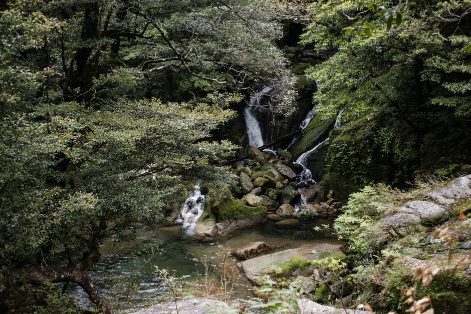
Yakushima is a round, mountainous island about 60 km (37 miles) south of Kyushu, in Kagoshima Prefecture, covered in some of the oldest and most magical forest in Japan. Its granite peaks rise to 1,936 m (6,352 ft) at Mount Miyanoura, the highest point in Kyushu, and catch so much moisture from the ocean that locals joke it rains “35 days a month”. The rain feeds mossy forests of yakusugi, Japanese cedars more than 1,000 years old, including the Jomon Sugi, thought to be one of the oldest trees in Japan. In 1993, Yakushima became one of Japan’s first two natural World Heritage sites. Come for long hikes to ancient cedars, waterfalls and rivers of clear water, sea turtles nesting on the beaches, deer and monkeys by the roads, and a hot spring in the rocks by the sea. Most hikers come from March to November.
Right now in Yakushima
- Wed19–23°C67–74°FClear
- Thu20–23°C69–74°F8 mm rain
- Fri20–26°C68–79°F13 mm rain
- Mon 12 Oct Sports Day (スポーツの日)
Top tours in Yakushima
See all tours for Yakushima →
From local operators, with prices and reviews; you check availability and book on Viator, our partner. We may earn a commission at no extra cost to you. How we earn money
Yakushima at a glance
- Best for: hiking among ancient cedars, mossy forests, waterfalls, wildlife, sea turtles and wild coastal hot springs.
- How long: 3 days at least; 4–5 days to hike to the Jomon Sugi and still see the rest of the island with a spare day for bad weather.
- Best time: March to May and October to November, with highs of about 18–25 °C (64–77 °F) at the coast; summer is hot and stormy.
- Getting there: about 2 to 3 hours by jetfoil from Kagoshima, about 4 hours by ferry, or about 35 minutes by air.
- Getting around: a rental car is best; local buses run around the coast, and a special bus serves the Jomon Sugi trailhead.
- Fees to know: a mountain conservation contribution of ¥1,000 for day hikes or ¥2,000 for overnight trips; the Arakawa trailhead bus costs ¥2,000 round trip; the jetfoil costs ¥14,000 one way, all as of October 2026.
- Typhoon damage in 2026: after a typhoon in September 2026, the road to Shiratani Unsuikyo was still closed on October 1; check trail conditions before you go.
- Before you go: entry rules, money and general safety are in our Japan travel guide.
Yakushima’s areas: where things are
The island is roughly round, about 130 km (80 miles) around, with a ring road along the coast and the mountains and forest filling the interior. Almost all villages, hotels and restaurants are on the coast.
Miyanoura and the north-east
The main ferry port and largest village, with shops, the tourist information center, the Yakushima Environmental Culture Village Center, hotels and the road up to Shiratani Unsuikyo. The airport is a few kilometers south.
Anbo and the east
The second port, with jetfoil services to Kagoshima, the Yakusugi Museum and the starting point for the Arakawa trail and Yakusugi Land. The best base for the Jomon Sugi hike.
Onoaida and the south
A warm, sunny coast with hot springs, the Hirauchi Kaichu Onsen in the rocks, the Ohko and Senpiro waterfalls, and a few resort hotels and guesthouses.
Nagata and the north-west
Long sandy beaches where loggerhead turtles nest in summer, and quiet guesthouses near Isso and Nagata.
The western forest road
The narrow Seibu Rindo road on the west coast passes through the World Heritage area from the mountains to the sea, with troops of Yakushima macaques and herds of Yakushika deer by the road.
Top things to see on Yakushima
The Jomon Sugi and the Arakawa trail
The Jomon Sugi is the largest and oldest-known yakusugi, a gnarled giant with a trunk about 16 m (52 ft) around, estimated at anywhere from 2,000 to 7,000 years old. Reaching it is a serious day hike: about 22 km (14 miles) round trip and 10 hours from the Arakawa trailhead, first along an old logging railway track, then up steep forest trails past the Wilson Stump, a huge hollow stump whose heart-shaped opening is a famous photo spot. Start before dawn, carry a headlamp, food, water and rain gear, and consider hiring a certified local guide. Visitors view the tree from a wooden deck to protect its roots.
According to the Ministry of the Environment, private vehicles are banned on the road to the Arakawa trailhead from March 1 to November 30 every year. Hikers must take the Arakawa hiking bus from the Yakusugi Museum, which, according to Yakushima Town’s mountain council, costs ¥2,000 (about US$13) round trip for junior high school students and up and ¥1,000 for younger children, as of October 2026; buy tickets in advance at the tourist information centers. The first buses leave the museum at 5 a.m., and the last bus back from the trailhead leaves at 5:45 p.m. Buses were suspended from September 9, 2026 after typhoon landslides, but the road reopened on September 16 and the council reported normal service in early October; check its notices before you plan.
Shiratani Unsuikyo
A gorge of moss-covered boulders, clear streams and cedar forest in the north-east, said to have inspired the forest in the film “Princess Mononoke”. Trails range from an hour’s walk to a half-day hike to the Taikoiwa Rock viewpoint. Normally the gorge is reached by bus or car from Miyanoura, and visitors are asked for a forest conservation contribution of ¥800 (about US$5.1). As of October 1, 2026, according to Yakushima Town’s mountain council, the prefectural road to Shiratani Unsuikyo was closed by landslides caused by a typhoon in early September, and the gorge could not be entered for the time being. Check the council’s website for the reopening date.
Yakusugi Land
A forest park at about 1,000–1,300 m (3,300–4,300 ft) in the south-east, with trails from 30 minutes to 2.5 hours past giant cedars, mossy rocks and rivers. It is easier than the Jomon Sugi hike and reachable by car or bus from Anbo. It reopened on September 16, 2026 after the typhoon closures.
Waterfalls
Ohko-no-taki, on the west coast, drops 88 m (289 ft) straight down a cliff near the road; it is one of Japan’s 100 best waterfalls. Senpiro-no-taki, in the south, slides down a huge granite slab into a gorge, and Toroki-no-taki falls directly into the sea.
Nagata Inakahama and the sea turtles
The beaches of Nagata are among the most important nesting sites for loggerhead turtles in the North Pacific, and the area is protected under the Ramsar Convention. From May to July, turtles come ashore at night to lay eggs, and hatchlings head for the sea from July to September. To protect them, night-time observation is allowed only with a guided program run by local groups, and flash photography and lights are forbidden.
More classic sights
- Hirauchi Kaichu Onsen: a hot spring in the rocks on the shore, usable only for about two hours around low tide; mixed bathing, swimsuits not allowed.
- Seibu Rindo: the western forest road through the World Heritage area, with monkeys and deer.
- Kigensugi: an ancient cedar right beside the road above Yakusugi Land, easy to see by car.
- Yakusugi Museum: displays on the cedars, logging history and the island’s forests, next to the Arakawa bus stop.
- Yakushima Environmental Culture Village Center: a large-screen film and exhibits about the island, in Miyanoura.
Nature
- Jōmon Sugi
- Senpiro Falls
- Shiratani Unsuikyo
Peaks and mountains
- Mount Miyanoura
Other sights
- Hirauchi Kaichū Onsen
- Yakusugi Land
Museums
- Yakusugi Museum
Hiking on Yakushima
Yakushima’s trails range from easy forest walks to multi-day traverses of the central mountains. Climbing Mount Miyanoura, the highest peak in Kyushu, takes a long day from the Yodogawa trailhead (about 8–10 hours round trip), or two days combined with the Jomon Sugi with a night in a mountain hut. Huts are free, basic and unstaffed; Takatsuka and Shin-Takatsuka huts near the Jomon Sugi were trialing advance registration in 2026. Camping near the Jomon Sugi is generally prohibited.
According to the Ministry of the Environment and Yakushima Town, hikers are asked to pay the World Natural Heritage Yakushima Mountain Environment Conservation Contribution, introduced in March 2017: ¥1,000 (about US$6.3) for a day hike and ¥2,000 (about US$13) for an overnight trip in the mountains, from junior high school age up. It is voluntary but set by town ordinance, and pays for mountain toilets and trail repairs; pay when you buy the Arakawa bus ticket, at the tourist information centers or at the trailheads. Submit a hiking plan, use the toilets at the trailheads, and carry a portable toilet bag, as some mountain toilets are closed. For more ideas, see our guide to hiking.
Activities and best months
- HikingThe Jomon Sugi trail starts at the Arakawa trailhead, closed to private cars from 1 March to 30 November: take the Arakawa hiking bus from the Yakusugi Museum (¥2,000 return); hikers are asked for the mountain conservation contribution (¥1,000 day, ¥2,000 overnight); Shiratani Unsuikyo has its own ¥800 forest contribution.
Other things to do on Yakushima
Food and drink
Yakushima’s food is simple and local. Tobiuo (flying fish) is the island’s signature catch, served fried whole with its wings spread, as sashimi or in fish cakes. Sabbushi, smoked and dried mackerel flakes, is used for broth and sprinkled on rice. Try local citrus such as tankan and ponkan in winter, and Mitake, a sweet-potato shochu distilled on the island with its soft water. Restaurants are few and close early; many visitors eat at their inn.
Rivers, sea and kayaking
The island’s clear rivers, such as the Anbo River, are popular for kayaking and stand-up paddling, and the coast has good snorkeling and diving in summer, with coral, turtles and tropical fish. Go with a local operator, as rivers rise very quickly after rain. See our guides to snorkeling and diving.
Wildlife
About 2,000 Yakushima macaques and Yakushika deer, both subspecies found only on the island and nearby, are easy to see along the western forest road and in the forests. Don’t feed them, and drive slowly.
Day trips and nearby islands
- Tanegashima: the flat neighboring island, home to the JAXA Tanegashima Space Center and surfing beaches, about 1 hour by jetfoil.
- Kuchinoerabujima: a volcanic island in Yakushima Town, with hot springs and hiking, reached by a town ferry from Miyanoura; check the volcanic alert level first.
- Kagoshima: the gateway city on the mainland, facing the smoking volcano Sakurajima, with black pork, shochu and Sengan-en garden.
- Ibusuki: sand baths on the beach south of Kagoshima, on the way to or from the jetfoil.
Nearby destinations
- Nagasaki273 km
Getting there and getting around
By jetfoil and ferry
The Toppy and Rocket jetfoils of Tane-Yaku Kosoku Sen sail from Kagoshima’s South Pier to Miyanoura or Anbo several times a day, some calling at Ibusuki or at Nishinoomote on Tanegashima. The fastest direct sailings take about 2 hours and those via Tanegashima about 2 hours 50 minutes. According to the operator, since May 11, 2026 the adult fare between Kagoshima and Yakushima is ¥14,000 (about US$89) one way and ¥25,900 (about US$164) for a round trip valid for 7 days. The slower car ferry Yakushima 2 takes about 4 hours from Kagoshima to Miyanoura, at a much lower fare. Jetfoils are often canceled in high seas, especially in winter and typhoon season, so book a flexible ticket and allow a spare day.
By air
Yakushima Airport, on the north-east coast, has flights from Kagoshima (about 35 minutes), Fukuoka and Osaka (Itami) on small turboprop planes. Kagoshima is about 1 hour 20 minutes by Kyushu Shinkansen from Hakata, covered by the Japan Rail Pass and JR Kyushu’s All Kyushu Rail Pass; the passes do not cover the jetfoil or the flights.
On the island
A rental car is the easiest way to explore, as buses run only along the coast and are infrequent; book ahead for holidays and bring an International Driving Permit. Drive slowly on the narrow western forest road and watch for monkeys and deer. Local buses link the airport, Miyanoura, Anbo and Onoaida, and connect with the Arakawa hiking bus and Yakusugi Land.
When to go and how long to stay
Yakushima has a warm, very wet climate at sea level and a cool, even wetter one in the mountains, where snow falls in winter. The table uses the Japan Meteorological Agency’s (JMA) 1991–2020 normals for its Yakushima station near the airport on the north-east coast: average daily highs and lows, total rain and days with at least 0.5 mm.
| Month | Average high / low | Rain (days with 0.5 mm or more) | What to expect |
|---|---|---|---|
| January | 15 °C (58 °F) / 9 °C (48 °F) | 295 mm (11.6 in), 17 days | Mild at the coast; snow on the peaks; jetfoils often canceled in rough seas |
| February | 16 °C (60 °F) / 9 °C (49 °F) | 289 mm (11.4 in), 15 days | Mild; plum blossoms; snow possible in the mountains |
| March | 18 °C (64 °F) / 11 °C (52 °F) | 387 mm (15.2 in), 16 days | Warming; rhododendrons begin in the lowlands; Arakawa bus starts on March 1 |
| April | 21 °C (71 °F) / 14 °C (58 °F) | 406 mm (16.0 in), 14 days | Pleasant; fresh green; good for hiking |
| May | 24 °C (76 °F) / 18 °C (64 °F) | 444 mm (17.5 in), 14 days | Warm; rhododendrons on the high peaks; turtle nesting begins; Golden Week crowds |
| June | 27 °C (80 °F) / 21 °C (70 °F) | 860 mm (33.9 in), 20 days | Rainy season usually from about May 30; the wettest month by far |
| July | 30 °C (87 °F) / 24 °C (75 °F) | 362 mm (14.3 in), 12 days | Hot and humid; rainy season usually ends around July 15; hatchlings from mid-month |
| August | 31 °C (88 °F) / 25 °C (76 °F) | 256 mm (10.1 in), 15 days | Hot; summer crowds; typhoons possible |
| September | 29 °C (84 °F) / 23 °C (73 °F) | 451 mm (17.7 in), 16 days | Hot and very wet; typhoons most likely |
| October | 25 °C (77 °F) / 19 °C (67 °F) | 310 mm (12.2 in), 13 days | Warm and clearer; a good hiking month |
| November | 21 °C (70 °F) / 15 °C (59 °F) | 310 mm (12.2 in), 13 days | Comfortable; autumn colors high up; Arakawa bus ends on November 30 |
| December | 17 °C (62 °F) / 11 °C (52 °F) | 282 mm (11.1 in), 16 days | Cool and quiet; snow on the summits |
Even at the coast, Yakushima gets about 4,650 mm (183 in) of rain a year, more than three times as much as Tokyo, with rain on about half the days; June alone averages about 860 mm (34 in). The mountains get far more. The JMA’s normal rainy season for southern Kyushu runs from about May 30 to July 15; in 2026 it ran from about May 20 to July 12. Rain gear is essential in every season, and hikes can be called off when rivers rise.
Weather month by month
Typhoons: according to the JMA’s 1991–2020 normals, about four typhoons a year come close to southern Kyushu, most often from July to September. A typhoon can stop jetfoils, ferries and flights for several days, close trails and roads, and cause landslides, as happened in September 2026. Keep extra days and follow the JMA’s warnings.
Crowds: Golden Week, mid-July to August and the autumn holidays are busiest, when the Arakawa bus and trailhead fill before dawn; the mountain council posts daily hiker numbers. March, early June and November are quieter.
Three days on Yakushima
Day one, Yakusugi Land and the Kigensugi cedar, then the waterfalls of the south and a soak at Hirauchi Kaichu Onsen at low tide. Day two, the Jomon Sugi hike from Arakawa, starting on the 5 a.m. bus. Day three, the western forest road for monkeys and deer, Ohko Falls and the beaches of Nagata.
Five days with Shiratani or the summit
Add Shiratani Unsuikyo (when it reopens) or a kayak trip on the Anbo River, and keep a spare day for rain or canceled boats. Strong hikers can climb Mount Miyanoura or stay a night in a mountain hut.
Where to stay on Yakushima and taxes
- Miyanoura: hotels, minshuku and guesthouses near the ferry port, shops and restaurants.
- Anbo: guesthouses and hotels closest to the Arakawa bus and Yakusugi Land, ideal for the Jomon Sugi hike.
- Onoaida and the south: resort hotels and hot spring inns on the sunny coast.
- Nagata and Isso: quiet guesthouses near the turtle beaches.
- Mountain huts: free, basic, unstaffed huts on the main trails for overnight hikes.
Many inns offer dinner and a packed breakfast or lunch for early hikes. As of October 2026, neither Yakushima Town nor Kagoshima Prefecture charges an accommodation tax; hot spring inns collect a small bathing tax, and hikers are asked for the conservation contribution described above.
What a trip to Yakushima costs
Prices are approximate, for October 2026, converted at about ¥158 to the US dollar.
| Item | Typical cost |
|---|---|
| Jetfoil Kagoshima–Yakushima, one way / round trip | ¥14,000 / ¥25,900 (about US$89 / US$164) |
| Mountain conservation contribution, day / overnight | ¥1,000 / ¥2,000 (about US$6.3 / US$13) |
| Arakawa hiking bus, round trip | ¥2,000 (about US$13) |
| Shiratani Unsuikyo contribution | ¥800 (about US$5.1) |
| Guided Jomon Sugi hike | ¥13,000–20,000 (about US$82–127) |
| Rental car, compact, per day | ¥6,000–10,000 (about US$38–63) |
| Minshuku with dinner and breakfast, per person | ¥9,000–15,000 (about US$57–95) |
| Resort hotel double, per night | ¥25,000–50,000 (about US$158–316) |
Practical tips for Yakushima
- Buy tickets early: get your Arakawa bus ticket and pay the conservation contribution the day before your hike, at the tourist information centers.
- Hire a guide: after the 2026 typhoon, the mountain council recommends joining a guided hike, as fallen trees and landslides remain a risk.
- Pack for rain: a proper waterproof jacket and trousers, and boots with good grip on wet roots and rocks, are essential.
- Cash: many minshuku, buses and small shops take cash only, and ATMs are few.
- Leave no trace: stay on the trails and decks, carry out all trash, and use portable toilet bags in the mountains.
- Visitor hotline: the JNTO’s Japan Visitor Hotline, 050-3816-2787, answers in English 24 hours a day.
Safety
Yakushima is safe, but its mountains are serious. Heavy rain can make rivers impassable within hours and trigger landslides; turn back if a stream is rising, and never cross a flooded river. In winter, the high peaks get snow and ice and are for experienced hikers only. Submit a hiking plan, start early, carry a headlamp, and expect no cell phone signal in many valleys. Typhoons from July to October can stop all transport to and from the island. At sea, currents and waves can be strong; swim at calm beaches only, and use Hirauchi Kaichu Onsen only at low tide. Nearby volcanoes are monitored by the JMA: as of October 4, 2026, Kuchinoerabujima, part of Yakushima Town, was at eruption alert level 1, and Sakurajima, across the bay from Kagoshima’s port, was at level 3, with entry restricted on the volcano; ash falls can occasionally disrupt Kagoshima. In an emergency, call 110 for the police, 119 for an ambulance or fire, or 118 for the Japan Coast Guard at sea.
What to pack for Yakushima
Waterproof jacket and trousers, waterproof hiking boots, quick-dry layers and a warm fleece for the mountains, a headlamp, a water bottle, a dry bag for your gear, a portable toilet bag, insect repellent, and a swimsuit for the coast. Japan uses 100 V and two-pin type A plugs like the US.
What to pack
- Day packs and anti-theft bagsA 20–30 litre pack carries layers, water, a head torch and snacks on full-day levada walks.
- Fleeces and warm layersSummits like Pico do Areeiro averaged about 11 °C over 2024, so a fleece is needed even in summer.
- HeadlampsLevada routes such as PR1 and PR9 pass through long, dark, wet tunnels.
- Hiking shoes and bootsMadeira's levadas and the Azores' crater rims are wet, rocky and slippery, so grippy shoes matter more than anywhere else in Portugal.
- Rain jacketsMountain and island weather changes fast; a real shell beats an umbrella in the wind.
- Trekking polesLong stone staircases and steep descents on Madeira's peaks and the Azores' crater rims are easier on the knees with poles.
- Water bottles and hydration packsAlgarve and Alentejo trails are hot and exposed with few refill points.
Yakushima travel FAQ
How long is the hike to the Jomon Sugi?
About 22 km (14 miles) round trip from the Arakawa trailhead, usually 10 hours, starting before dawn.
Can I drive to the Arakawa trailhead?
Not from March 1 to November 30, when private cars are banned; take the Arakawa hiking bus from the Yakusugi Museum, ¥2,000 round trip.
How much is the Yakushima mountain conservation fee?
¥1,000 for a day hike and ¥2,000 for an overnight trip in the mountains, from junior high school age; it is a contribution set by town ordinance.
Is Shiratani Unsuikyo open?
As of October 1, 2026, the road to Shiratani Unsuikyo was closed by typhoon landslides, and the gorge could not be visited; check the mountain council’s updates.
How do I get to Yakushima?
By jetfoil from Kagoshima (about 2–3 hours, ¥14,000 one way), by car ferry (about 4 hours) or by air from Kagoshima, Fukuoka or Osaka.
How many days do I need on Yakushima?
At least three; four or five let you hike to the Jomon Sugi and keep a spare day for rain or canceled boats.
Does it really rain all the time on Yakushima?
Often: the coast averages about 4,650 mm (183 in) a year and rain falls on about half the days, with even more in the mountains.
Do I need a guide on Yakushima?
Not for the main trails, but a certified guide is recommended for the Jomon Sugi, especially in bad weather or after storm damage.
When can I see sea turtles on Yakushima?
Turtles nest at Nagata from May to July and hatchlings emerge from July to September; night viewing is only with guided programs.
Do I need a car on Yakushima?
A car is the easiest way to get around, as buses are infrequent; many visitors rent one or book guided tours with transport.
Plan your trip
Partner links: TravelerCenter may earn a commission if you book, at no extra cost to you.
🇯🇵 Useful Japanese phrases for Yakushima
All 38 Japanese phrases: restaurant, hotel, emergencies, romance (printable) →
Sources · last reviewed 4 October 2026
Researched and last reviewed on 4 October 2026. Mountain conservation contribution, Arakawa bus fares, timetable and suspension, Shiratani Unsuikyo closure and trail status after the September 2026 typhoon: Yakushima Town (Yakushima Mountain Conservation and Use Council); Arakawa trailhead vehicle ban and Jomon Sugi rules: the Ministry of the Environment (Yakushima World Heritage Conservation Center); jetfoil fares and times: Tane-Yaku Kosoku Sen; JR Kyushu passes: JR Kyushu; climate normals, rainy season, typhoon statistics and volcanic alert levels: the Japan Meteorological Agency (JMA); visitor hotline: JNTO; exchange rate: the US Federal Reserve. Population, geography, the age of the cedars, sight descriptions, flights, ferry times, the absence of an accommodation tax, wildlife figures and typical prices are general references or estimates, flagged for checking. Prices and hours change, so check the official sites before you go. For entry rules, money and general safety, see our Japan travel guide.
Also: env.go.jp · JMA normals 1991–2020, Yakushima (climate)
Data: Weather: MET Norway (CC BY 4.0) · Sea temperature: NOAA CoastWatch · Rates: ECB · Holidays: Nager.Date · Costs: World Bank ICP and price levels · © OpenStreetMap contributors (ODBL) · Wikidata (CC0)