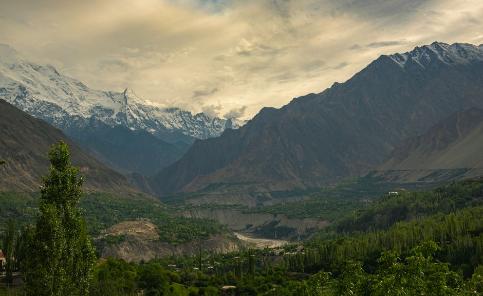
The Hunza Valley, in Gilgit-Baltistan in Pakistan’s far north, is one of the most spectacular mountain valleys in the world: a ribbon of green terraces, poplar groves and apricot orchards along the Hunza River, walled in by the Karakoram, with more than a dozen peaks above 7,000 m (23,000 ft) in view. The Karakoram Highway runs its length on the way to China, linking the old capital of Karimabad, crowned by the 700-year-old Baltit Fort, with the turquoise Attabad Lake, the jagged Passu Cones, swaying suspension bridges and, at the top, the Khunjerab Pass, at about 4,700 m (15,400 ft) on the Chinese border. Snow-capped Rakaposhi (7,788 m / 25,551 ft) towers over the lower valley, and glaciers reach almost down to the road. Hunza’s people, mostly Ismaili Muslims speaking Burushaski or Wakhi, are known for their warm welcome, their schools and their apricots. The valley is reached by a weather-dependent flight to Gilgit followed by a two- to three-hour drive, or by a long road journey from Islamabad. The season runs from April, when the orchards blossom, to early November, when the poplars turn gold; in winter, it is very cold, and many hotels close.
Right now in Hunza Valley (Karimabad)
- Wed 8–17°C 46–63°F 4 mm Partly cloudy
- Thu 7–16°C 44–60°F 4 mm Mostly clear
- Fri 5–14°C 41–58°F Clear
Weather: MET Norway (CC BY 4.0)
Top tours in Hunza Valley
See all tours for Hunza Valley →
From local operators, with prices and reviews; you check availability and book on Viator, our partner. We may earn a commission at no extra cost to you. How we earn money
Hunza Valley at a glance
- Best for: mountain views, forts and old villages, glaciers and lakes, suspension bridges, day hikes and treks, road trips on the Karakoram Highway, blossom and autumn colors.
- How long: 4–6 days, including a day trip to the Khunjerab Pass; add travel days to and from Islamabad.
- Best time: April for blossom; May to October for hiking and the Khunjerab Pass; late October to early November for autumn colors.
- Getting there: fly from Islamabad to Gilgit in about an hour, then drive about 100 km (62 miles) to Karimabad; or travel by road from Islamabad in about 14–18 hours.
- Getting around: by car with a driver, local minivans, or on foot around Karimabad.
- Good to know: all foreigners must register with the local authorities in Gilgit-Baltistan, and landslides can close roads at any time.
- Before you go: the e-visa, permissions, money and general safety are in our Pakistan travel guide.
Access, permits and rules (as of October 2026)
Registration and permits
No special permit or No Objection Certificate is normally needed to visit Hunza, Nagar, Gilgit or the Khunjerab Pass, but all foreign nationals must register with the local authorities when visiting Gilgit-Baltistan; in practice, police at checkpoints on the Karakoram Highway record passport details, and hotels register guests, so keep photocopies of your passport and visa handy. Climbing peaks above 6,000 m (19,700 ft) and some treks near the border need permits, which can take up to two months to arrange through a licensed operator. Foreigners may not go within 10 miles (16 km) of the Chinese border except at the official Khunjerab crossing. Tourist visas can be extended in Gilgit-Baltistan by the Deputy Commissioners of Gilgit and Skardu.
Khunjerab National Park
The drive to the Khunjerab Pass passes through Khunjerab National Park, created to protect snow leopards, Marco Polo sheep and ibex; foreigners pay an entry fee at the park gate near Sost, in recent years about US$8–10 or the rupee equivalent.
Rules to know
- Dress modestly: cover shoulders and legs, especially in villages.
- Ask before photographing people, particularly women.
- Alcohol is not sold to visitors; importing it into Pakistan is illegal.
- Carry out your rubbish from trails and viewpoints.
The main areas of the Hunza Valley
The valley in brief
The Hunza River flows south from the Khunjerab Pass to join the Gilgit River near Gilgit. Travelers usually divide the valley into Lower Hunza, around Rakaposhi; Central Hunza, with Karimabad, Altit and Nagar across the river; and Upper Hunza or Gojal, the Wakhi-speaking area beyond Attabad Lake, with Gulmit, Passu and Sost. Nagar, on the south bank, is a separate district with its own glaciers.
Karimabad and Altit
The old capital of the Mirs of Hunza, at about 2,500 m (8,200 ft), climbs a hillside below Baltit Fort, with stone lanes, terraced fields, craft shops, cafés and the best choice of hotels. The village of Altit, a short walk east, has its own older fort and a royal garden. Above town, the Eagle’s Nest viewpoint at Duikar is famous for sunrise over Rakaposhi, Diran, Ladyfinger and Golden Peak.
Lower Hunza and Nagar
Along the highway south of Karimabad, the Rakaposhi viewpoint at Ghulmet gives close views of the mountain’s huge north face. Across the river, the Nagar valley leads to the Hopper (Hoper) Glacier and Golden Peak.
Attabad Lake and Gojal
In January 2010, a huge landslide blocked the Hunza River and created Attabad Lake, about 20 km (12 miles) long and strikingly turquoise; the highway now passes it through a series of tunnels built with Chinese help. Beyond lie Gulmit, with old Wakhi houses, Hussaini with its suspension bridge, Passu beneath the Passu Cones and glaciers, and Sost, the last town before China.
Where to stay in the Hunza Valley
- Karimabad: the widest range, from guesthouses to hotels with terraces facing Rakaposhi; the best base.
- Altit: quieter guesthouses near the fort.
- Attabad Lake and Gulmit: lakeside hotels and glamping, and traditional guesthouses in Gojal.
- Passu: simple lodges for hikers, with glacier views.
Many places close from about November to March. Book ahead for July, August, Eid holidays and the blossom and autumn seasons, and ask about heating, hot water and generators.
Top things to see in the Hunza Valley
Baltit Fort
Perched above Karimabad, Baltit Fort, about 700 years old, was the palace of the Mirs of Hunza until 1945. Restored by the Aga Khan Trust for Culture and opened as a museum in 1996, it has wooden rooms, carved windows, royal artifacts and a rooftop with views up and down the valley. Visits are by guided tour.
Altit Fort
Older still, Altit Fort, said to be about 1,000 years old, stands on a cliff above the Hunza River, with a watchtower and carved woodwork; it was restored in 2007 and won a UNESCO Asia-Pacific heritage award. The Royal Garden below has apricot and cherry trees and a café.
Eagle’s Nest and Rakaposhi views
A steep road leads from Karimabad to Duikar and the Eagle’s Nest viewpoint, at about 2,900 m (9,500 ft), where sunrise lights up Rakaposhi, Diran, Ultar Sar, Ladyfinger and Golden Peak. Lower down, the Rakaposhi viewpoint at Ghulmet brings you within sight of the glacier tumbling from its summit.
Attabad Lake
The turquoise lake, created by the 2010 landslide, has boat rides, jet skis, lakeside cafés and hotels; it is busiest in summer.
Passu Cones and the Hussaini Bridge
The serrated Passu Cones (Tupopdan) rise above Passu village, one of the most photographed views in Pakistan. Nearby, the Hussaini suspension bridge, a swaying line of planks and cables over the river, is a popular, nerve-testing walk; take care in wind.
Khunjerab Pass
The highway climbs from Sost to the Khunjerab Pass, at about 4,700 m (15,400 ft), the highest paved border crossing in the world, marked by a stone gate on the Chinese border. The drive takes about 2–3 hours each way from Passu or Sost, through Khunjerab National Park, where you may see marmots, yaks and ibex. The pass is usually open from about April or May to November or December and can close at short notice because of snow; altitude sickness is possible, so do not linger long at the top.
More classic sights
- Ganish: an old village below Karimabad with watchtowers and carved mosques, restored with the Aga Khan Trust for Culture.
- Borith Lake: a small lake near Hussaini, with views of the Ghulkin Glacier.
- Passu and Batura glaciers: among the longest outside the polar regions, with viewpoints near the road.
- Hoper Glacier: in Nagar, a short drive from Karimabad.
- Sacred Rocks of Hunza: carvings and inscriptions near Ganish left by travelers on the old trade routes.
Hikes, treks and activities
Day hikes
From Karimabad, walk the water channels that irrigate the terraces, hike to the Ultar Glacier meadow (about 3–4 hours up), or climb to the Duikar viewpoint; around Passu, follow trails to the Passu Glacier, Borith Lake and the Patundas plateau for views of the Batura and Passu glaciers. See our hiking guide.
Treks
Longer treks include Rush Lake in Nagar, one of the highest alpine lakes in Pakistan at about 4,700 m (15,400 ft); the Shimshal valley; and the routes around the Batura Glacier. Use a licensed operator and local guide, carry layers for cold nights, and check permit requirements.
Blossom, autumn and festivals
In April, apricot, cherry and almond trees blossom across the valley; from late October to early November, the poplars and apricot leaves turn gold and red. Local festivals mark the sowing and harvest, and Navroz, the Persian New Year, is celebrated on March 21.
Food and drink
Hunza food features apricots fresh and dried, apricot-kernel oil, walnuts, mulberries and cherries, chapshuro (meat-filled flatbread), diram fitti (sweet wheat bread), soups and buckwheat bread. Cafés in Karimabad serve walnut cake and apricot juice. Tap water is not safe; drink filtered or bottled water.
Crafts
Karimabad’s shops sell handwoven woolen caps, embroidery, carpets, gemstones from the Karakoram and dried fruit; women’s craft cooperatives support local families.
Around the Hunza Valley
- Gilgit: the regional capital, about 100 km (62 miles) south, with the airport, markets, the Kargah Buddha carved on a cliff and the Naltar Valley nearby.
- Naltar Valley: pine forests and colorful lakes, about 2 hours from Gilgit by jeep.
- Fairy Meadows: meadows facing Nanga Parbat, reached by jeep and on foot from Raikot Bridge on the Karakoram Highway, about 3–4 hours from Gilgit.
- Skardu: the base for Deosai and K2 expeditions, about 6–7 hours by road from Gilgit.
- Islamabad: the starting point for flights and road trips north. See our Islamabad guide.
- China: over the Khunjerab Pass to Tashkurgan and Kashgar, with a Chinese visa or visa-free eligibility. See our China guide.
Nearby destinations
- Srinagar248 km
Getting there
By air
Flights from Islamabad to Gilgit take about an hour and are among the most scenic in the world, passing Nanga Parbat. They operate only in clear weather and are frequently delayed or cancelled, sometimes for several days; keep spare days and a road alternative. From Gilgit, it is about 100 km (62 miles), or 2–3 hours, by road to Karimabad.
By road
From Islamabad, the Karakoram Highway runs north via Abbottabad, Mansehra, Besham, Dasu and Chilas to Gilgit and Hunza, about 600 km (370 miles) to Gilgit, taking 14–18 hours or more depending on landslides and checkpoints. The section between Mansehra and Chilas has a history of attacks on travelers and frequent landslides. In summer, many travelers take the N15 through the Kaghan Valley and over the Babusar Pass (about 4,170 m / 13,700 ft), usually open from about June to October, rejoining the highway at Chilas, often with an overnight stop in Naran or Chilas. Travel only in daylight, in good weather, with an experienced driver.
From China
The Khunjerab Pass crossing to Tashkurgan in Xinjiang is open to foreign tourists seasonally, usually from about April to November; you need a Pakistani visa to enter Pakistan and the right Chinese documents to leave.
Getting around: practical details
Most visitors hire a car with a driver for the whole trip from Islamabad or Gilgit, which is the safest option on mountain roads; four-wheel-drive jeeps are needed for Fairy Meadows, Naltar and some side valleys. Shared minivans run along the highway between Gilgit, Karimabad, Gulmit, Passu and Sost. Fuel and ATMs are limited in Upper Hunza, so carry cash and fill up in Gilgit or Aliabad.
When to go and how long to stay
Hunza has a dry mountain climate with hot summer days in the valley bottoms, cold nights and harsh winters. April brings blossom and cool, changeable weather; May to September is warm and sunny in the valley, often around 25–30 °C (77–86 °F) by day in Karimabad, though much colder at the passes; October is crisp and clear, and late October to early November brings the autumn colors, before temperatures drop below freezing at night. From December to March, snow covers the upper valley, the Khunjerab Pass closes, flights are often cancelled and many hotels shut. The monsoon from late June to September brings little rain to Hunza itself but can trigger landslides and glacial floods along the Karakoram Highway. No 1991–2020 WMO normals are published for Gilgit-Baltistan stations, so the table below is a guide to seasons rather than measured averages.
| Month | Typical conditions in Karimabad | What to expect |
|---|---|---|
| January | Very cold, often below freezing; snow possible | Many hotels closed; Khunjerab closed |
| February | Very cold | Quiet; winter festivals in villages |
| March | Cold nights, cool days | First blossom late in the month; Navroz on March 21 |
| April | Cool and changeable | Apricot and cherry blossom; Khunjerab usually reopens in April or May |
| May | Mild, sunny | Green terraces; good hiking |
| June | Warm days, cool nights | Peak trekking season begins; Babusar Pass usually opens |
| July | Warm to hot in the valley | Busiest month; landslide risk on the highway |
| August | Warm | Busy; fruit harvest |
| September | Warm days, cool nights | Clear skies; quieter |
| October | Crisp and clear | Autumn colors from late October |
| November | Cold nights, below freezing | Golden poplars in early November; season ends |
| December | Very cold | Khunjerab and Babusar closed |
Five days in the Hunza Valley
Day 1: arrive in Karimabad, walk to Altit Fort and the Royal Garden. Day 2: Baltit Fort and Ganish in the morning, the Ultar meadow hike in the afternoon. Day 3: sunrise at the Eagle’s Nest, then drive to Attabad Lake, Gulmit and Passu. Day 4: the Khunjerab Pass and back to Passu, with the Hussaini Bridge on the way. Day 5: return to Gilgit for the flight, stopping at the Rakaposhi viewpoint.
Three days
Karimabad and its forts, the Eagle’s Nest, Attabad Lake and the Passu Cones.
What a trip to the Hunza Valley costs
Prices are approximate, for October 2026, converted at about 277 rupees to the US dollar.
| Item | Typical cost |
|---|---|
| Baltit Fort entry for foreigners | about 1,500–2,000 PKR (about US$5.40–7.20) |
| Altit Fort entry for foreigners | about 1,500 PKR (about US$5.40) |
| Khunjerab National Park fee | about US$8–10 |
| Flight Islamabad–Gilgit, one way | 15,000–30,000 PKR (about US$54–108) |
| Car with driver, per day | 12,000–20,000 PKR (about US$43–72) plus fuel |
| Shared minivan Gilgit–Karimabad | 600–1,000 PKR (about US$2.15–3.60) |
| Meal in a local restaurant | 800–2,000 PKR (about US$2.90–7.20) |
| Mid-range hotel double, per night | 10,000–25,000 PKR (about US$36–90) |
Practical tips for the Hunza Valley
- Leave spare days: flights and roads can be closed by weather or landslides.
- Carry passport copies: for police registration at checkpoints.
- Bring cash: ATMs are few, especially in Upper Hunza.
- Acclimatize: take it easy at the Khunjerab Pass, at about 4,700 m (15,400 ft).
- Travel in daylight: never drive mountain roads at night.
- Check what is open: many hotels and restaurants close in winter.
Safety
Hunza itself is known as one of the most peaceful parts of Pakistan, but getting there and moving around involve real hazards. Landslides frequently block or destroy the Karakoram Highway and other mountain roads, especially during the monsoon from late June to September and during spring thaws; rockfall can occur without warning, and glacial lake outburst floods have hit villages in Gilgit-Baltistan. Travel only in daylight and clear weather, with an experienced driver, and follow local warnings. The highway between Mansehra and Chilas has a history of attacks on travelers; many visitors fly to Gilgit or use the Babusar route in summer. Political activity around elections in Gilgit-Baltistan can bring road closures and a heavier security presence. Altitude sickness is possible at the Khunjerab Pass and on treks; ascend slowly. Suspension bridges are unstable in wind, and glacier walks need a guide. Medical care is limited; the main hospitals are in Aliabad and Gilgit, and serious cases go to Islamabad, so have insurance that covers helicopter rescue. In an emergency, call 15 for police and 1122 for rescue and ambulance.
What to pack for the Hunza Valley
Layers for big temperature changes, a warm jacket, hat and gloves for the Khunjerab Pass and cold nights, sturdy hiking shoes, a rain jacket, sunglasses and high-factor sunscreen for the strong mountain sun, a water filter or purification tablets, a flashlight for power cuts, modest clothes, cash, and an adapter for round two-pin or British-style plugs. See our hiking shoes, rain jackets and travel adapters guides.
Hunza Valley travel FAQ
Do foreigners need a permit to visit Hunza?
No special permit is normally needed, but all foreigners must register with the local authorities in Gilgit-Baltistan, which is done at checkpoints and hotels.
How do I get to Hunza from Islamabad?
Fly to Gilgit in about an hour and drive 2–3 hours to Karimabad, or travel by road in about 14–18 hours via the Karakoram Highway or, in summer, the Babusar Pass.
Are flights to Gilgit reliable?
They depend on clear weather and are often delayed or cancelled, so allow spare days and have a road alternative.
When is the Khunjerab Pass open?
Usually from about April or May to November or December, depending on snow; it can close at short notice.
What is the best time to visit Hunza?
April for blossom, May to October for hiking, and late October to early November for autumn colors.
Is the Karakoram Highway safe?
The road through Hunza is well used, but landslides are frequent, and the section between Mansehra and Chilas has a history of attacks. Travel in daylight with an experienced driver.
How many days do I need in Hunza?
Four to six days in the valley, plus travel days to and from Islamabad.
Where should I stay in Hunza?
Karimabad is the best base, with views of Rakaposhi; Gulmit, Passu and Attabad Lake suit Upper Hunza.
How high is Karimabad?
About 2,500 m (8,200 ft); the Khunjerab Pass is about 4,700 m (15,400 ft).
Can I cross from Hunza to China?
Yes, via the Khunjerab Pass to Tashkurgan when it is open, with the right Chinese visa or visa-free eligibility.
Sources and last review
Researched and last reviewed on 5 October 2026. Registration of foreigners in Gilgit-Baltistan, permits for peaks above 6,000 m, distance limits near the Chinese border, flight reliability to Gilgit, the Babusar Pass, landslides on the Karakoram Highway, the Mansehra–Chilas section, the Khunjerab crossing season and election-related disruption: the UK government’s factual entry and safety pages; visa extensions by the Deputy Commissioners of Gilgit and Skardu: the Directorate General of Immigration and Passports. No 1991–2020 WMO normals exist for Gilgit-Baltistan in the published dataset, so the season table is descriptive. The exchange rate is a cross rate from the Central Bank of Myanmar’s published rates. Fort ages and restorations, peak heights, Attabad Lake’s formation, distances, journey times, national park and fort fees, emergency numbers and typical prices are general references or estimates, flagged for checking. Roads and rules change, so check locally before you go. For entry rules, money and general safety, see our Pakistan travel guide.
Plan your trip
Partner links: TravelerCenter may earn a commission if you book, at no extra cost to you.
🇵🇰 Useful Urdu phrases for Hunza Valley
All 38 Urdu phrases: restaurant, hotel, emergencies, romance (printable) →