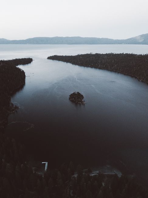
Lake Tahoe is a huge, deep alpine lake high in the Sierra Nevada, straddling the border between California and Nevada at about 6,230 ft (1,900 m), famous for water so clear you can see far below the surface, granite shores and pine forests ringed by peaks. In summer it is a playground for beaches, kayaking, paddleboarding, hiking and cycling; in winter it has some of the biggest ski resorts in the West. South Lake Tahoe and Stateline, with their casinos, are the liveliest area; Tahoe City and the North Shore are quieter. Fall is calm and golden but brief: in October 2026 many summer services have already closed, nights are freezing, and the first snow can bring chain controls on the mountain roads.
Right now in Lake Tahoe (Tahoe City)
- Tue10–25°C49–76°FClear
- Wed10–26°C49–78°FClear
- Thu10–24°C50–74°FClear
- Mon 12 Oct Columbus Day
- Mon 12 Oct Indigenous Peoples' Day · regional holiday in California
Top tours in Lake Tahoe
See all tours for Lake Tahoe →
From local operators, with prices and reviews; you check availability and book on Viator, our partner. We may earn a commission at no extra cost to you. How we earn money
Lake Tahoe at a glance
- Best for: beaches and boating in summer, skiing and snowboarding in winter, hiking, mountain biking, scenic drives and a few nights by the lake.
- How long: 2–3 days to drive around the lake and enjoy one shore; a week for a ski trip or a relaxed summer holiday.
- Best time: July to early September for warm days on the water; December to March for skiing; September for quieter, sunny days.
- Getting there: Reno-Tahoe International Airport (RNO) is about an hour from the lake; San Francisco is about 3.5–4 hours by car without traffic, Sacramento about 2 hours.
- Two states: the lake is shared by California and Nevada, both on Pacific time; casinos are on the Nevada side.
- Before you go: entry rules, money, tipping and driving are in our United States travel guide.
Lake Tahoe’s shores: where to base yourself
A scenic road of about 72 miles (116 km) circles the lake. Each shore has a different character, and in traffic it can take an hour or more to cross from one to another.
South Lake Tahoe and Stateline
The busiest area, where the California city of South Lake Tahoe meets Stateline, Nevada, with its high-rise casino hotels and shows. It has the most hotels, restaurants and nightlife, the Heavenly gondola rising from the town center, and long sandy beaches nearby.
The West Shore and Emerald Bay
Highway 89 winds along the forested West Shore past Emerald Bay, the most photographed spot on the lake, and quiet state parks with old-growth pines. There are few services and a slower pace.
Tahoe City and the North Shore
Tahoe City, where the Truckee River leaves the lake, has shops, restaurants and a lakeside path. Further east are Kings Beach and, across the Nevada line, Incline Village and Crystal Bay. Palisades Tahoe and Northstar ski resorts are a short drive away, and the historic railroad town of Truckee is 15 miles (24 km) north.
The East Shore
Nevada’s East Shore is the least developed, with granite boulders, coves of turquoise water and Sand Harbor, the lake’s favorite beach park.
Top things to see at Lake Tahoe
Fees and seasons below were checked on the official park sites in October 2026; check again before you go.
Emerald Bay and Vikingsholm
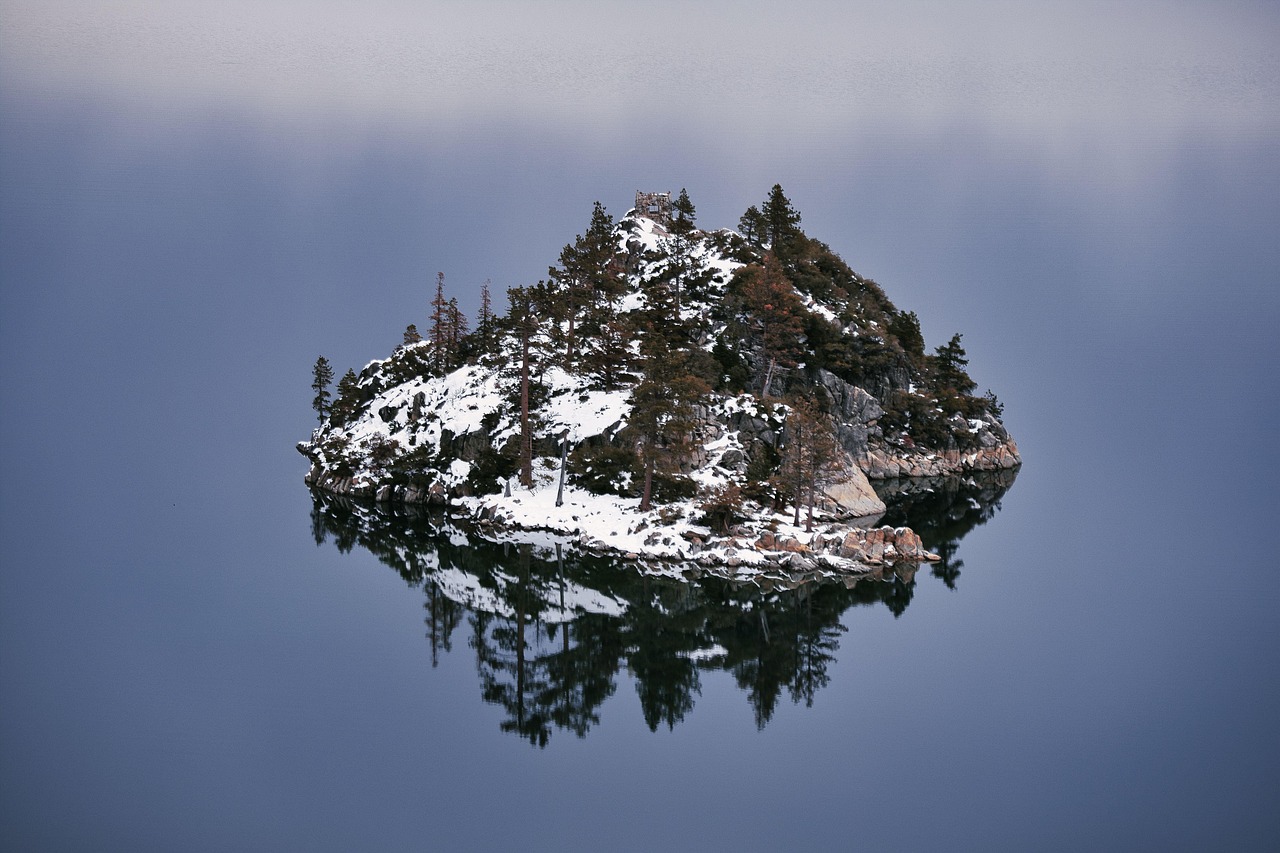
From the overlooks on Highway 89, Emerald Bay curves below you around Fannette Island, the lake’s only island, with a tiny stone teahouse on top. A steep trail of about a mile (1.6 km) drops some 500 ft (150 m) from the Harvey West parking lot to Vikingsholm, a 1929 Scandinavian-style mansion on the shore; the climb back is hard at this altitude. Day use costs $10 per vehicle, or $3 for an hour, and the lot is open from sunrise to sunset; it fills early in summer, so arrive before 9 a.m. or after 3 p.m. House tours of Vikingsholm ended for 2026 on September 30, and the Eagle Point and boat-in campgrounds are closed for the season. Federal passes such as America the Beautiful are not accepted at California state parks.
D.L. Bliss and Sugar Pine Point state parks
Next to Emerald Bay, D.L. Bliss State Park has clear coves and the start of the Rubicon Trail, one of the lake’s loveliest shoreline walks, which leads to Emerald Bay. Since October 1, 2026, the park is closed to vehicles for the off-season: walk in from the visitor center lot on Highway 89 (about a mile to the nearest trailhead and a steep 2 miles, or 3 km, to the beaches), with no restrooms or water. Further north, Sugar Pine Point State Park ($10 per vehicle all year) has a historic lakeside mansion, a pier and quiet forest trails.
Sand Harbor
On the Nevada shore south of Incline Village, Sand Harbor has smooth granite boulders, white-sand coves and water of every shade of blue and green, with a boardwalk and summer Shakespeare festival. Entry costs $10 per vehicle, or $15 for vehicles not registered in Nevada, and the park opens from 8 a.m. to an hour after sunset. Day-use reservations are needed only from May 15 to September 30; the boat launch is closed for the season. Dogs are allowed from October 15 to April 15 on a 6-ft leash.
Heavenly gondola and the ski resorts
In summer, the Heavenly gondola from South Lake Tahoe climbs to an observation deck with sweeping lake views; check its fall schedule before you go. In winter, the area’s big resorts include Heavenly on the south shore, Palisades Tahoe (site of the 1960 Winter Olympics) and Northstar near the north shore, and Kirkwood to the south. For 2026–27, resorts were planning to open from about November 20 to early December, conditions permitting, according to secondary sources; check each resort’s announcements.
Other things to do at Lake Tahoe
On the water: kayaks, paddleboards and boats are rented around the lake from late spring to early fall. The water is cold even in August, and much colder in fall, so wear a life jacket and stay close to shore; afternoon winds can whip up waves quickly. See our boat trips and beaches guides. Hiking: the Rubicon Trail, Eagle Lake above Emerald Bay and sections of the 165-mile (265 km) Tahoe Rim Trail have huge views; at this altitude, take it slowly. See our hiking guide. Cycling: paved lakeside paths run from Tahoe City along the West Shore and the Truckee River, and the East Shore Trail leads to Sand Harbor. See our cycling guide.
Bears, cold and staying safe
- Black bears are very active around the lake, according to California State Parks. Store all food and scented items in bear lockers at parks and campgrounds, never leave food or coolers in your car, and lock bear-proof containers; fines can reach $1,000.
- Cold water: sudden immersion is dangerous even on hot days.
- Altitude and sun: drink plenty of water and wear sunscreen; the thin air makes exertion harder and sunburn quicker.
- Wildfire: there was no active fire in the Tahoe Basin on CAL FIRE’s list in early October 2026, but late summer and fall are fire season in the Sierra; follow fire restrictions and check the AirNow map for smoke.
Truckee, Reno and beyond
- Truckee: a historic railroad and mountain town with a lively main street, and Donner Lake nearby.
- Reno and Carson City: Nevada’s casino city and the state capital, both under an hour from the lake.
- Yosemite National Park: about 4 hours south via the eastern Sierra when Tioga Road is open in summer and fall; see our Yosemite National Park guide.
- San Francisco and wine country: about 3.5–4 hours west; see our San Francisco travel guide. Napa Valley is about 3 hours away.
Nearby destinations
- Yosemite National Park155 km
- Napa Valley215 km
- San Francisco254 km
Getting there and getting around
By air: Reno-Tahoe International Airport (RNO) is the main gateway, about 35 miles (56 km) from Incline Village and about 58 miles (93 km) from South Lake Tahoe. Sacramento (SMF) and San Francisco (SFO) airports are further away but have more flights.
By car: from the Bay Area, Interstate 80 leads over Donner Summit to Truckee and the North Shore, and US 50 over Echo Summit to South Lake Tahoe, about 105 miles (169 km) from Sacramento. Friday evenings heading up and Sunday afternoons heading back are very slow, especially in ski season.
Winter driving and chain controls: from the first storms of fall until spring, Caltrans and Nevada can require chains on mountain roads. Under California’s rules, R-1 requires chains except on passenger cars and light trucks with snow tires on at least two drive wheels; R-2 requires chains except on four-wheel or all-wheel drive vehicles with snow-tread tires on all four wheels (which must still carry chains); and R-3 requires chains on all vehicles, though a road is often closed before that. The speed limit with chains is 25 or 30 miles per hour (40–48 km/h). Highway 89 at Emerald Bay can close in heavy snow. Check Caltrans QuickMap or call 1-800-427-7623 before you travel; on October 4, 2026, no restrictions were reported on the main Tahoe highways.
Without a car: on the North Shore, TART Connect is a free on-demand shuttle within zones, from 6:30 a.m. to 10 p.m.; on the South Shore, the Tahoe Transportation District’s Lake Link is an on-demand rideshare service that anyone can use. The summer Emerald Bay shuttle ended its 2026 season on September 7. Many ski resorts run winter shuttles from lodging areas.
When to go and how long to stay
Tahoe has warm, dry summers and snowy winters, with cold nights all year. The table uses NOAA’s 1991–2020 normals for Tahoe City on the North Shore, at 6,230 ft (1,899 m).
| Season | Average high / low | Precipitation per month | What it’s like |
|---|---|---|---|
| Winter (Dec–Feb) | 40–41 °F (4–5 °C) / 21 °F (−6 °C) | 5.7–6.2 in (145–158 mm), mostly snow | Ski season; chain controls common; snowy roads. |
| Spring (Mar–May) | 45–59 °F (7–15 °C) / 24–34 °F (−4 to 1 °C) | 1.6–5 in (40–126 mm) | Spring skiing into April; muddy trails; quiet lake. |
| Summer (Jun–Aug) | 69–78 °F (21–26 °C) / 40–46 °F (4–8 °C) | Under 0.7 in (16 mm) | Sunny and busy; beaches, boats and hiking; afternoon storms now and then. |
| Fall (Sep–Nov) | 70 °F falling to 48 °F (21–9 °C) / 41 °F falling to 26 °F (5 to −3 °C) | 0.4–3.2 in (11–82 mm) | Calm and golden in September; freezing nights and first snow from October. |
Tahoe City gets about 33 inches (845 mm) of precipitation a year, most of it as snow from November to April. South Lake Tahoe is a little drier.
How long to stay: 2, 3 and 5 days
2 days: drive around the lake in a day, stopping at Emerald Bay, D.L. Bliss, Tahoe City and Sand Harbor, then spend a day on the water or a beach. 3 days: add the Rubicon Trail or Eagle Lake and a ride on the Heavenly gondola. 5 days: add Truckee and Donner Lake, a bike ride on the lakeside paths, and an evening in Stateline or Reno. In winter, plan 3–5 days of skiing.
Where to stay at Lake Tahoe and the room taxes
- South Lake Tahoe and Stateline: the widest choice, from motels to casino resorts and ski lodges near Heavenly.
- Tahoe City and the West Shore: cabins, inns and vacation rentals in the forest.
- Incline Village and Kings Beach: lakefront resorts and rentals on the North Shore.
- Truckee, Olympic Valley and Northstar: for skiers.
Room rates are quoted before tax and peak in July, August and ski holidays. Taxes vary by side of the lake. According to Placer County, the North Shore (Tahoe City, Kings Beach) charges a 10% transient occupancy tax plus a North Lake Tahoe tourism assessment of 1–2%, depending on the zone. According to Douglas County, Nevada, lodging at Stateline and the Lake Tahoe township pays 14% plus $5 per room per night. The City of South Lake Tahoe charges 12% at most lodgings (14% at some newer properties) plus a tourism district fee of $4–$5.50 per night, according to summaries of the city’s information. Vacation rentals have their own rules and permits.
Practical tips for Lake Tahoe
- Sales tax: according to the state tax agency (CDTFA), the rate is 8.75% in South Lake Tahoe, 7.25% in unincorporated Placer County (Tahoe City) and 9% in Truckee as of October 2026; Nevada sets its own rates.
- Park passes: California state parks and Nevada’s Sand Harbor charge their own fees; federal America the Beautiful passes are not valid there.
- Parking: popular lots fill by mid-morning in summer; park legally, as cars on highway shoulders are towed.
- Off-season: October and November are quiet “shoulder” months, with some restaurants and attractions closed or on reduced hours.
- Emergencies: call 911.
What to pack for Lake Tahoe
Pack layers in every season: summer days are warm but mornings and evenings are cool, and from October nights fall below freezing. Bring a warm jacket, hat and gloves, hiking shoes, high-factor sunscreen and sunglasses for the strong mountain sun, swimwear and a quick-dry towel in summer, and, from fall to spring, snow chains that fit your car or a rental with suitable tires.
Lake Tahoe travel FAQ
Is Lake Tahoe in California or Nevada?
Both. About two-thirds of the lake is in California and one-third in Nevada; both sides use Pacific time.
Can you tour Vikingsholm in October?
Not in 2026: house tours ended for the year on September 30. You can still walk down to the shore and see the outside, with day-use parking at $10 per vehicle.
How much does it cost to visit Sand Harbor?
$10 per vehicle, or $15 for vehicles not registered in Nevada, as of October 2026. Reservations are needed only from May 15 to September 30.
Do I need snow chains for Lake Tahoe?
From fall to spring, carry chains or have a four-wheel or all-wheel drive vehicle with snow tires. Chain controls can be imposed on short notice during storms; check Caltrans before you go.
When do the Tahoe ski resorts open for 2026–27?
Most plan to open between late November and early December, conditions permitting. Check each resort’s announcements.
How far is Lake Tahoe from San Francisco?
About 190–200 miles (305–320 km), roughly 3.5–4 hours by car without traffic, longer on Friday evenings and in snow.
Can you swim in Lake Tahoe?
Yes, in summer, though the water is cold. Swim close to shore, wear a life jacket on boats and boards, and watch for afternoon wind.
Are there bears at Lake Tahoe?
Yes, and they are very active. Use bear lockers, never leave food in your car and lock bear-proof containers.
What taxes are added to Lake Tahoe hotel bills?
It depends on the shore: 10% plus a 1–2% assessment on Placer County’s North Shore, 14% plus $5 a night at Stateline, Nevada, and about 12% plus a nightly district fee in South Lake Tahoe.
Plan your trip
Partner links: TravelerCenter may earn a commission if you book, at no extra cost to you.
Sources · last reviewed 4 October 2026
Researched and last reviewed on 4 October 2026. Emerald Bay, Vikingsholm, D.L. Bliss and Sugar Pine Point fees and seasons and bear warnings: California State Parks; Sand Harbor: Nevada State Parks; road conditions and chain-control rules: Caltrans; fire status: CAL FIRE; TART Connect: Tahoe Truckee Area Regional Transit; Lake Link and the Emerald Bay shuttle: Tahoe Transportation District; hotel taxes: Placer County and Douglas County, Nevada; sales tax: the California Department of Tax and Fee Administration; climate: NOAA’s 1991–2020 normals for Tahoe City. Ski-resort opening dates, South Lake Tahoe’s hotel tax, distances and general descriptions come from secondary or summarized sources and are flagged for checking. Check the official sites before you go. For entry rules, tipping and driving, see our United States travel guide.
Data: Weather: MET Norway (CC BY 4.0) · Air quality: OpenAQ · Rates: ECB · Holidays: Nager.Date · Costs: World Bank ICP and price levels · Wikidata (CC0)