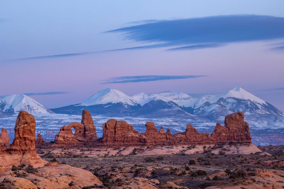
Moab is a small desert town of about 5,400 people on the Colorado River in southeast Utah, and one of the great outdoor bases in the American West. Arches National Park is 5 miles (8 km) up the road, Canyonlands and Dead Horse Point are a 40-minute drive away, and all around lie red-rock canyons, slickrock domes and the snowcapped La Sal Mountains. People come to hike, raft the Colorado, ride the famous Slickrock and Porcupine Rim mountain-bike trails, drive four-wheel-drive tracks and watch some of the darkest night skies in the country. The town itself is relaxed and practical, with motels, outfitters and cafés along Main Street. Spring and autumn are glorious and busy; summer is very hot, with flash floods from late-summer storms, so plan your days around the heat.
Right now in Moab
- Tue 18–31°C 64–88°F Mostly clear
- Wed 16–30°C 61–87°F Partly cloudy
- Thu 16–29°C 60–84°F Clear
- Mon 12 Oct Columbus Day · regional holiday in Utah
Weather: MET Norway (CC BY 4.0) · Holidays: Nager.Date
Top tours in Moab
See all tours for Moab →
From local operators, with prices and reviews; you check availability and book on Viator, our partner. We may earn a commission at no extra cost to you. How we earn money
Moab at a glance
- Best months: April–May and late September to October, with highs of about 65–85 °F (18–29 °C). Late May and early June bring the biggest river flows; July and August are very hot.
- Time needed: three days for Arches, Canyonlands’ Island in the Sky and Dead Horse Point; four or five to add rafting, biking or a jeep tour.
- Getting there: by car; Moab is about 237 miles (381 km) from Salt Lake City, 113 miles (182 km) from Grand Junction and roughly 455 miles (730 km) from Las Vegas.
- Costs (as of October 2026): Arches and Canyonlands $30 per car each, or $55 for an annual pass to both; Dead Horse Point State Park $20 per car; Sand Flats $10 per car.
- Before you go: entry rules for international visitors (ESTA or visa), driving and tipping are on our United States travel guide.
Parks and passes around Moab (as of October 2026)
The land around Moab is managed by several different agencies, and each has its own fees and rules. Federal passes do not work at the state park or at Sand Flats, so it helps to know who runs what.
| Place | Run by | Entry | Passes accepted |
|---|---|---|---|
| Arches National Park | National Park Service | $30 per car, $25 motorcycle, $15 per person; 7 days | Southeast Utah Parks pass, America the Beautiful |
| Canyonlands National Park | National Park Service | $30 per car, $25 motorcycle, $15 per person; 7 days | Southeast Utah Parks pass, America the Beautiful |
| Dead Horse Point State Park | Utah State Parks | $20 per car (up to 8 people), $10 per motorcycle, $10 per group of 4 on foot or bike | Utah State Parks passes only |
| Sand Flats Recreation Area (Slickrock Trail) | Grand County and the Bureau of Land Management | $10 per car, $5 per bike or motorcycle; 7 days | Own $35 annual pass; federal and state passes not valid (except the federal Access Pass) |
The Southeast Utah Parks annual pass ($55, US citizens and residents) covers Arches, Canyonlands, Natural Bridges and Hovenweep for a year. The America the Beautiful pass ($80 for US residents, $250 for non-residents) covers every national park. Arches and Canyonlands do not charge the $100 non-resident fee that applies in 2026 at Zion, Bryce Canyon, the Grand Canyon and eight other parks, so the $250 pass pays off mainly if your trip includes those. National park entrance stations take cards only. In 2026 Arches does not require a timed-entry reservation, but the park may hold cars at the gate for hours when it is full; plans for 2027 had not been announced in October 2026.
Top things to see around Moab
Arches National Park
Just 5 miles (8 km) north of town, Arches has more than 2,000 natural stone arches. Drive the scenic road to Balanced Rock, the Windows Section and Devils Garden, walk to Landscape Arch, and hike the 3-mile (4.8 km) round-trip trail to Delicate Arch for sunset. The ranger-led Fiery Furnace hike ($16) and self-guided Fiery Furnace permits ($10) must be booked on Recreation.gov. To avoid the entrance lines, the park recommends arriving before 8 a.m. or after 3 p.m. Our Arches National Park guide on this site covers fees, trails and permits in detail.
Canyonlands: Island in the Sky
Canyonlands is Utah’s largest national park, divided by the Colorado and Green rivers into districts that are not connected by road inside the park. The Island in the Sky is the easiest to see in a day: a mesa standing more than 1,000 ft (304 m) above the surrounding canyons, with overlooks along a paved scenic drive. To get there, drive 10 miles (16 km) north of Moab on US 191, then 22 miles (35 km) southwest on UT 313, about 40 minutes in all; the park advises using a map, as GPS may send you the wrong way. Do not miss the short walk (0.5 miles / 0.8 km round trip) to Mesa Arch at sunrise, the Green River Overlook and Grand View Point. The 100-mile (161 km) White Rim Road loops below the mesa for four-wheel drivers and mountain bikers.
The Needles, reached by UT 211 south of Moab, is a longer drive and better for hikers with a full day or more; the Maze is reached only on rough dirt roads and is for experienced backcountry travelers.
Dead Horse Point State Park
On the same mesa as Island in the Sky, on the way there, Dead Horse Point looks far down to a great gooseneck bend of the Colorado River, one of the most photographed views in the Southwest. The park is open 6 a.m.–10 p.m. all year, and the visitor center 7 a.m.–5 p.m. daily (closed Thanksgiving, Christmas and New Year’s Day). It is also an International Dark Sky Park, but day-use visitors must leave by 10 p.m.; campers and ranger-led stargazing groups can stay later. Unlike the national parks, it welcomes leashed dogs on its hiking and mountain-bike trails. Mountain bikes and e-bikes can be rented at the trailhead.
Scenic Byway 128 along the Colorado River
Utah State Route 128, the Upper Colorado River Scenic Byway, leaves US 191 at the river bridge on the north edge of town and runs 44.6 miles (71.7 km) upstream. For the first 13 miles (21 km) it squeezes through a narrow red-rock gorge beside the water, with riverside campgrounds, the Big Bend bouldering area and the trailhead for Grandstaff Canyon, a shady streamside hike to Morning Glory Natural Bridge. Then the valley opens into Castle Valley and Professor Valley, backdrops for classic western films, and the dark spires of the Fisher Towers. The road continues to the site of the historic Dewey Bridge, destroyed by fire in 2008. Late afternoon is the best time to drive it, when the cliffs glow on the way back to town.
Potash Road, Corona Arch and dinosaur tracks
Just north of town, Potash Road (Utah State Route 279) follows the river past climbing walls at Wall Street, petroglyph panels and the trailhead for Corona Arch, a huge arch on Bureau of Land Management land outside the national parks. Another state byway, it is lovely at sunset. North of Moab, the Bureau of Land Management’s Mill Canyon Dinosaur Tracksite shows fossil footprints in the rock.
Rafting and river trips
The Colorado River runs right past town, and on a hot day the water is where you want to be. Local guides run everything from half-day floats to week-long expeditions, and the travel council recommends going with a guide unless you have your own gear and experience. Private trips need a permit from the Bureau of Land Management or the National Park Service, depending on the section. See our boat trips guide for general advice.
| Section | Length | What it’s like |
|---|---|---|
| Moab Daily (Colorado River along SR-128) | 13 miles (21 km) | Half-day or full-day trip with gentle rapids; good for families, from children to seniors |
| Westwater Canyon | 17 miles (27 km) | One or two days of Class IV whitewater, including Skull Rapid, past black rock more than 1.2 billion years old |
| Cataract Canyon (Canyonlands) | about 100 miles (161 km) | Multi-day expedition below the confluence, with 14 miles (23 km) of rapids up to Class V and the Big Drops |
| Labyrinth Canyon (Green River) | 3 to 6 days | Flatwater with no rapids; canoes and kayaks; permit needed for self-guided trips |
Water levels follow the snowmelt: the biggest, wildest water usually comes from late May to early June, while later summer brings calmer floats with chances to swim. Jet-boat tours offer a smooth-water ride for anyone who would rather stay dry. Always wear the life jacket your guide gives you; the Colorado is cold and strong even when it looks calm.
Mountain biking and cycling
Moab is one of the world’s great mountain-bike destinations, and local shops rent bikes and helmets, run shuttles to trailheads and offer guided rides. See our cycling guide for general advice.
- Slickrock Trail and Porcupine Rim: the famous rides, in the Sand Flats Recreation Area just east of town, a 9,000-acre area of slickrock domes and fins below the La Sal Mountains. Slickrock is technical and physically demanding, on grippy sandstone; Porcupine Rim has exposed edges. Entry is $10 per car or $5 per bike for 7 days, and 140 first-come campsites cost $20 per vehicle per night.
- Bar M (Moab Brands): more than 30 miles (48 km) of trails for all levels just north of town, with views of Arches; a National Recreation Trail since 2020. The paved Moab Canyon Pathway runs about 10 miles (16 km) from town to the trailhead.
- Navajo Rocks: flowy loops over slickrock and sand with views of the Monitor and Merrimac buttes.
- The Whole Enchilada and the Raptor Route: long descents from the La Sal foothills toward the river, usually ridden with a shuttle to the top.
- White Rim Road: a 100-mile (161 km) multi-day ride below Island in the Sky; camping needs a Canyonlands backcountry permit.
Inside Arches and Canyonlands, bikes must stay on roads. Most trails around Moab have little shade, so carry more water than you think you need and ride early in summer.
Other things to do in Moab
- Jeep and off-road tours: the Moab Field Office of the Bureau of Land Management manages 1.8 million acres of canyon country with famous four-wheel-drive routes. Tour companies run open-air jeep trips if you would rather not drive yourself. The Shafer Trail descent from Island in the Sky needs a high-clearance vehicle.
- Hiking: besides the national parks, try Grandstaff Canyon, Corona Arch and Fisher Towers. Our hiking guide has general tips.
- Climbing and canyoneering: Wall Street on Potash Road and the boulders along SR-128 are classics; canyoneering in Arches needs a permit.
- Stargazing: Arches, Canyonlands and Dead Horse Point are all certified dark-sky places. Drive a few miles out of town on a moonless night.
- Horseback riding: seasonal rides along the river in Castle Valley.
Day trips from Moab
- Canyonlands: The Needles: colorful spires, arches and long hiking loops in the southern district, reached by UT 211.
- Natural Bridges National Monument: three large natural bridges, covered by the Southeast Utah Parks pass.
- Monument Valley: about 150 miles (240 km) south on the Navajo Nation, a long day trip or a stop on the way to the Grand Canyon. It is a tribal park with its own fee, and national park passes are not valid.
- Grand Canyon: the South Rim is a full day’s drive, about 330 miles (530 km) via Monument Valley; see our Grand Canyon National Park guide.
Nearby destinations
- Arches National Park17 km
- Monument Valley183 km
- Aspen246 km
- Bryce Canyon National Park252 km
- Park City286 km
- Vail299 km
Getting there and getting around
Most visitors drive. There is no public transportation to Arches or Canyonlands, and you will need a car to reach the trailheads, though bike paths and shuttle companies help. Driving tips are in our United States travel guide.
| From | Distance to Moab | Notes |
|---|---|---|
| Canyonlands Regional Airport (CNY) | 16 miles (26 km) | Small regional airport north of town |
| Grand Junction, CO (GJT) | 113 miles (182 km) | Interstate 70 and US 191, or the scenic SR-128 |
| Salt Lake City, UT (SLC) | 237 miles (381 km) | US 6 and US 191; about 4 hours |
| Denver, CO | about 355 miles (570 km) | Interstate 70 west |
| Las Vegas, NV | about 455 miles (730 km) | Interstate 15 and Interstate 70; about 7 hours |
By train or bus: Amtrak’s California Zephyr and intercity buses stop at Green River, Utah, and Grand Junction, Colorado; commercial vans connect them, and Salt Lake City, with Moab. From Las Vegas: many visitors fly into Las Vegas and drive a loop through Zion, Bryce Canyon, Moab, Monument Valley and the Grand Canyon; see our Las Vegas travel guide.
Getting around: fill up with fuel in Moab, as there is none inside the national parks. Large RVs have limited parking at Arches and at Island in the Sky, where vehicles over 25 ft (7.6 m) can park only at a few lots; leave trailers in town if you can.
When to go and how long to stay
Moab sits at about 4,050 ft (1,235 m) in high desert. Spring and autumn are the main seasons, with warm days and cool nights. Summer often passes 100 °F (38 °C), and from July to September the monsoon brings afternoon thunderstorms and flash floods. Winter is cold but often sunny and very quiet, with only light snow in town.
| Season | Average high | Average low | What it’s like |
|---|---|---|---|
| Spring (Mar–May) | 65–83 °F (18–28 °C) | 36–51 °F (2–11 °C) | Peak season; Easter week very busy; rivers rise in May. |
| Summer (Jun–Aug) | 94–99 °F (34–37 °C) | 59–66 °F (15–19 °C) | Very hot; start at dawn; river trips; storms from July. |
| Autumn (Sep–Nov) | 88–57 °F (31–14 °C) | 55–30 °F (13 to −1 °C) | Warm then crisp; busy to mid-October; wettest month is October. |
| Winter (Dec–Feb) | 44–52 °F (7–11 °C) | 21–27 °F (−6 to −3 °C) | Cold nights, few crowds, snow on the La Sals. |
Figures are NOAA 1991–2020 normals for the Moab weather station. Moab gets about 9.1 inches (232 mm) of rain a year and about 9 inches (24 cm) of snow, most of it in December.
Staying safe in the heat and flash floods
Rangers in Arches and Canyonlands respond to hundreds of search-and-rescue calls a year, many for heat illness. From April to September temperatures can top 85 °F (29 °C), and July and August often pass 100 °F (38 °C), with very little shade on the trails. Plan hikes and rides for early morning or evening, avoiding 10 a.m. to 5 p.m. in summer. Drink at least 1 gallon (4 liters) of water per person per day, carry 2–3 liters on short hikes, eat salty snacks, and turn back when half your water is gone. Rock can be hotter than the air. Never leave children or pets in a parked car.
Flash floods can sweep down dry washes and slot canyons with little warning, sometimes from storms many miles away while the sky above you is clear. Before any canyon hike, check the National Weather Service flash flood outlook for southeast Utah. If you see water rising, turning muddy or carrying debris, or hear a roar, climb to higher ground at once. Never cross a flooded wash or road; 6 inches (15 cm) of moving water can knock you off your feet. Dirt roads can become impassable after rain. When thunder rolls, get to your car or a building and wait 30 minutes after the last thunder.
How long to stay: 3, 4 and 5 days
Three days: Arches early on day one, with Delicate Arch at sunset; Dead Horse Point and Island in the Sky on day two, starting with sunrise at Mesa Arch; a half-day float on the Colorado and the drive along SR-128 on day three. Four days: add a guided jeep tour or a morning on the Slickrock Trail. Five days: add the Needles district or the Fiery Furnace, and a night of stargazing.
Where to stay in Moab: lodging and taxes
Moab has chain hotels along Main Street (US 191), small motels, guest ranches, vacation rentals and many campgrounds. There is no lodging inside Arches or Canyonlands, so the town fills up from March to October, especially at Easter and on holiday weekends; book well ahead.
- Downtown Moab: walk to restaurants, outfitters and shops; the easiest base without a car in the evenings.
- North of town and along SR-128: river-view lodges and guest ranches, closer to Arches; quieter but you will drive everywhere.
- Camping: Devils Garden in Arches and Island in the Sky in Canyonlands, the yurts and campgrounds at Dead Horse Point (RV sites $50–60 a night), Sand Flats ($20, first-come) and riverside BLM campgrounds along SR-128, which fill by mid-morning in season.
Taxes: room rates in Moab are quoted before tax. Your bill adds Utah state and local sales tax plus transient room taxes; according to Grand County’s published rate sheet, the state, county and city room taxes come to about 6% in the City of Moab (state 0.32%, county 4.25%, city 1.5%) and about 4.6% elsewhere in the county, on top of sales tax. Ask for the total, with all taxes and any resort or cleaning fees, before you book.
Practical tips for Moab
- Start early: the national parks recommend entering before 8 a.m. or after 3 p.m.; Arches lots are often full by 7:30 a.m. in summer.
- Phones: service is patchy outside town and in the parks. Download maps for offline use and tell someone your plans. Emergencies: call 911.
- GPS: the National Park Service warns that navigation apps may send you the wrong way to Canyonlands; use a map.
- Leave no trace: stay on trails and slickrock to protect the black, crusty living soil; do not stack or knock down cairns.
- Dogs: welcome on leash at Dead Horse Point and on many BLM trails, but not on national park trails.
- Time zone: Utah uses Mountain Time with daylight saving time, so in summer Moab is one hour ahead of Arizona and Las Vegas.
- Money: prices in shops and restaurants exclude sales tax; tip in sit-down restaurants and for river and jeep guides (see our United States travel guide).
What to pack for Moab
Pack a big water bottle or hydration pack for each person, salty snacks, a wide-brimmed hat, sunglasses and strong sunscreen, and shoes with sticky soles for slickrock. Bring river sandals that strap on and quick-dry clothes for rafting, a light rain jacket for summer storms, warm layers for desert nights and stargazing, and a headlamp. Mountain bikers should bring spare tubes and a pump even with tubeless tires. In winter, add a warm coat, gloves and traction devices for icy trails.
Moab travel FAQ
How far is Moab from Arches National Park?
The Arches entrance is 5 miles (8 km) north of Moab on US 191, about 10 minutes by car.
How far is Canyonlands from Moab?
The Island in the Sky Visitor Center is 32 miles (51 km) from Moab, about 40 minutes. The Needles is farther, south of town on UT 211.
Do I need a reservation for Arches in 2026?
No timed-entry reservation is required in 2026, but expect delays when the park is full. Fiery Furnace hikes and Devils Garden Campground still need bookings; 2027 plans had not been announced in October 2026.
Is my national park pass valid at Dead Horse Point?
No. Dead Horse Point is a Utah state park with its own fee, $20 per car in 2026. Sand Flats also has its own fee.
When is the best time for rafting in Moab?
Late May to early June for the biggest water; later summer for gentler floats and swimming. Guided half-day trips on the Moab Daily section suit families.
Is Moab too hot in summer?
July highs average about 99 °F (37 °C). You can still visit: hike at dawn, spend the afternoon on the river or in town, and return to the parks for sunset and stars. Watch for flash floods from July to September.
How much is the Slickrock Trail?
The trail is in the Sand Flats Recreation Area: $10 per car or $5 per bike or motorcycle for 7 days. National park and state park passes are not valid there.
How many days do you need in Moab?
Three days covers Arches, Island in the Sky and Dead Horse Point with a river float; four or five lets you add biking, a jeep tour or the Needles.
Can I visit Moab from Las Vegas?
Yes, but it is about 455 miles (730 km), roughly 7 hours each way, so it fits best into a loop of several days with Zion, Bryce Canyon and the Grand Canyon.
Sources and last review
Researched and last reviewed on 4 October 2026. Arches and Canyonlands fees, passes, timed-entry status, directions, district information, heat and flash-flood advice come from the National Park Service; Dead Horse Point hours, fees and rules from Utah State Parks; Sand Flats fees and the Colorado Riverway from the Bureau of Land Management; rafting sections, bike trail systems and Scenic Byway 128 from the Moab Area Travel Council (Discover Moab); population from Wikidata; climate from NOAA’s 1991–2020 normals for the Moab station. Distances to Las Vegas, Denver, Monument Valley and the Grand Canyon are estimates flagged for checking, and we could not confirm the current Grand County lodging tax rate, so check your bill. For entry rules, driving and tipping, see our United States travel guide.
Plan your trip
Partner links: TravelerCenter may earn a commission if you book, at no extra cost to you.