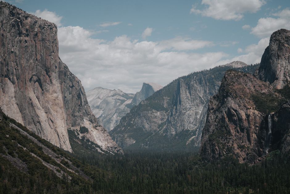
Yosemite National Park protects nearly 1,200 square miles (about 3,100 km²) of California’s Sierra Nevada, and its heart is Yosemite Valley: a glacier-carved canyon of sheer granite walls, with El Capitan and Half Dome rising thousands of feet above meadows, the Merced River and some of the highest waterfalls in North America. Beyond the valley are giant sequoias in the Mariposa Grove, the high-country lakes and domes of Tuolumne Meadows along the Tioga Road, and the sweeping view from Glacier Point. The park is open all year, but snow closes its high roads from about November to May, and waterfalls are at their best in spring. In October 2026 there is no entry reservation, but non-US visitors pay a $100 non-resident fee, and the Dome Fire near Wawona has closed Glacier Point Road and brought smoke to parts of the park.
Right now in Yosemite National Park (Yosemite Valley)
- Wed9–29°C49–84°FClear
- Thu10–29°C49–84°FClear
- Fri11–26°C51–80°FMostly clear
- Mon 12 Oct Columbus Day
- Mon 12 Oct Indigenous Peoples' Day · regional holiday in California
Top tours in Yosemite National Park
See all tours for Yosemite National Park →
From local operators, with prices and reviews; you check availability and book on Viator, our partner. We may earn a commission at no extra cost to you. How we earn money
Yosemite at a glance
- Best months: May and June for roaring waterfalls; September and early October for quieter trails and fall color. Summer is busiest; winter is snowy and peaceful in the valley.
- Time needed: one full day for Yosemite Valley; three or four days to add the Mariposa Grove, Glacier Point and the Tioga Road high country.
- Getting there: Yosemite Valley is 195 miles (314 km), about 4–5 hours, from San Francisco and 313 miles (504 km), about 6 hours, from Los Angeles, or take the train to Merced and the YARTS bus.
- Fees (as of October 2026): $35 per car for 7 days, plus $100 per person for non-US residents aged 16 and over without an annual or America the Beautiful pass. Cards only. No reservation needed in 2026.
- Before you go: entry rules for international visitors (ESTA or visa), driving and tipping are in our United States travel guide.
What’s open in October 2026
The Dome Fire, Glacier Point Road and smoke
The Dome Fire started on September 15, 2026, north of Wawona Dome near the Chilnualna Falls trailhead, and was caused by a campfire, according to CAL FIRE. On October 3 the park reported about 6,600 acres (2,700 hectares) burned and 40% containment, and said Yosemite was open and operating normally apart from these closures: Glacier Point Road is temporarily closed for smoke and firefighting, with no reopening date; the Chilnualna Falls Trail, the trails toward Buena Vista and Crescent lakes, and the Ostrander Lake Trail and everything south of it are closed, an area east of the Wawona Road from Wawona to Chinquapin. Hikers can still walk up to Glacier Point on the Four Mile and Panorama trails. Smoke can bring periods of unhealthy air, especially in the mornings in Yosemite Valley and El Portal: check the park’s air-quality page and fire news before you go. Fire restrictions apply below 8,000 ft (2,438 m).
Tioga Road and other seasonal closures
Tioga Road (Highway 120 East), the 45.5-mile (73 km) high road from Crane Flat over Tioga Pass at 9,943 ft (3,031 m) to the eastern Sierra, was open in early October 2026, with short roadwork delays near Tuolumne Meadows and between Olmsted Point and Tioga Pass. It opened on May 15, 2026, the earliest in 16 years. The park says the road is typically open from late May or June until sometime in November, when the first big snowstorm closes it for winter; Glacier Point Road and Mariposa Grove Road also close for the winter. There is no overnight parking along Tioga Road or in its parking lots from October 15. If you plan to cross the Sierra by Tioga Pass in late October or November, have a backup route: the all-year detour from Reno is about 100 miles (160 km) longer.
Other works in fall 2026: El Capitan Bridge repairs cause 15-minute delays on weekdays (7 a.m.–7 p.m.) through December, and the upper Mist Trail, from the John Muir Trail junction to the top of Vernal Fall, is open only Friday to Sunday and holidays (and weekday evenings from 3:30 p.m. to 7 a.m.) through October. Waterfalls are low in autumn: in early October Yosemite Falls was dry and Vernal, Nevada and Bridalveil falls were low.
Reservations: none in 2026, nothing announced for 2027
After several years of summer timed-entry and peak-hours reservation systems, Yosemite announced on February 18, 2026, that it would not require vehicle reservations in 2026, relying instead on real-time traffic and parking management, more shuttles and entrance wait times published online. A park survey in August found that 91% of visitors waited less than 15 minutes to enter, and the superintendent said Covid-era access restrictions were not needed. As of October 4, 2026, the park had not announced its plans for 2027; check its reservations page before booking a summer 2027 trip. Lodging, campgrounds and Half Dome permits still need reservations.
Entrance fees and passes (as of October 2026)
All entrances except Hetch Hetchy are open 24 hours a day; the park is cashless, taking cards and mobile payment only. Buy a digital pass on Recreation.gov before you arrive to save time at the gate.
| Pass | Price | What it covers |
|---|---|---|
| Private vehicle | $35 | One car, van or RV (up to 15 seats), 7 days |
| Motorcycle | $30 | Up to 2 motorcycles, 4 riders, 7 days |
| Per person (foot, bike, horse, bus) | $20 | Each person 16 or over; 15 and under free |
| Non-resident fee | +$100 per person | Non-US residents 16 and over, including on commercial tours, unless entering with an annual or America the Beautiful pass |
| Yosemite annual pass | $70 | This park, 12 months; US citizens and residents |
| America the Beautiful pass | $80 residents / $250 non-residents | All national parks and federal lands for 12 months |
For international visitors: a couple from abroad in a rental car would pay $35 plus $200 in non-resident fees, so the $250 non-resident America the Beautiful pass, which covers the pass holder and everyone in one car, is almost always the better deal, and it also waives the $100 fee at Sequoia and Kings Canyon and the Grand Canyon. The non-resident fee is part of a 2026 federal rule applied at 11 of the busiest national parks. US residents get in free on the remaining 2026 fee-free days, October 27 and November 11.
Top things to see in Yosemite
Yosemite Valley: El Capitan, Half Dome and the falls
The valley floor sits at about 4,000 ft (1,200 m), and almost everything is within a short walk or shuttle ride: the Tunnel View pull-out on the Wawona Road, with the classic picture of El Capitan, Bridalveil Fall and Half Dome; El Capitan Meadow, where you can watch climbers on the 3,000-foot wall; the easy loop to the base of Lower Yosemite Fall; and Cook’s Meadow and Sentinel Bridge for Half Dome reflected in the river. The Yosemite Valley Welcome Center, the museum and the Ansel Adams Gallery are in Yosemite Village.
Glacier Point
From 3,200 ft (975 m) above the valley, Glacier Point looks straight across at Half Dome and down onto Vernal and Nevada falls; it is a little less than an hour’s drive from the valley when the road is open, usually from May to November. The road was closed in early October 2026 because of the Dome Fire; hikers can still climb up on the steep Four Mile Trail.
The Mariposa Grove of giant sequoias
Near the South Entrance, the grove has more than 500 mature giant sequoias, among them the Grizzly Giant, around 3,000 years old. Park at the Welcome Plaza (about 300 spaces, full by late morning) and take the free shuttle; only cars with a disability placard may drive the road. In 2026 the shuttle runs 8 a.m.–5 p.m. until October 31 (last bus back 5:30 p.m.) and 8 a.m.–3:30 p.m. in November, weather permitting; in winter you walk or ski up. The Big Trees Loop is 0.3 mile (0.5 km) and accessible; the Grizzly Giant Loop is 2 miles (3.2 km) with 300 ft (90 m) of climbing. Pets are not allowed in the grove.
Tuolumne Meadows and the Tioga Road
About 1.5 hours from the valley, at 8,600 ft (2,600 m), Tuolumne Meadows is a wide subalpine meadow ringed by granite domes. Stop on the way at Olmsted Point for a view of the back of Half Dome, and at Tenaya Lake for a picnic on its sandy shore. There is no longer gas at Tuolumne Meadows. The road continues over Tioga Pass to Lee Vining and Mono Lake.
Hetch Hetchy
In the quieter northwest corner, about 1.5 hours from the valley, the dammed Hetch Hetchy Reservoir supplies San Francisco’s water. A walk across O’Shaughnessy Dam leads to trails past Wapama Falls. The road is open from sunrise to sunset and closes when snow is falling or forecast.
Peaks and mountains
- El Capitan
- Half Dome
Viewpoints
- Glacier Point
- Tioga Pass
- Tunnel View
Other sights
- Yosemite Falls
Nature
- Hetch Hetchy
- Mariposa Grove
- Tuolumne Meadows
- Yosemite Valley
Hiking, Half Dome and climbing
- Mist Trail to Vernal Fall: granite steps beside the waterfall, wet with spray in spring; turn back at the footbridge for an easier walk. Note the weekday closure of the upper section through October 2026.
- Upper Yosemite Fall Trail: a steep, all-day climb to the top of the tallest waterfall in the park, with huge views over the valley.
- Valley Loop and Mirror Lake: flat walks on the valley floor; Mirror Lake reflects Half Dome in spring.
- Half Dome: a 14–16 mile (23–26 km) round trip and nearly 5,000 ft (1,500 m) of climbing, ending with steel cables up the granite dome. A permit is required whenever the cables are up, normally from the Friday before Memorial Day to the day after the second Monday in October, so the last day in 2026 is expected to be October 13. Up to 300 people a day are allowed; permits come from a preseason lottery in March and a daily lottery two days ahead on Recreation.gov, for a $10 application fee plus $10 per person.
Yosemite is also the birthplace of big-wall rock climbing; guided lessons run from Curry Village and Tuolumne in season. Black bears live throughout the park: store all food and scented items in the metal lockers provided, never leave food in your car, and stay at least 50 yards (46 m) away. Rocks by rivers and waterfalls are slippery and swift water is deadly, so stay behind railings. See our hiking guide.
Activities and best months
- HikingJunJulAugSepHalf Dome needs a permit whenever the cables are up (normally from the Friday before Memorial Day to mid-October): at most 300 hikers a day, by a preseason lottery in March or a daily lottery two days ahead ($10 plus $10 a person).
Getting there and getting around
There are five entrances: the South Entrance (Highway 41 from Fresno), Arch Rock (Highway 140 from Merced), Big Oak Flat (Highway 120 from Manteca and the Bay Area), Hetch Hetchy, and Tioga Pass (Highway 120 from the east, summer and fall only). Gas is sold 24 hours a day by card at Wawona, Crane Flat and El Portal, but not in Yosemite Valley.
| From | Distance to Yosemite Valley | Time and route |
|---|---|---|
| San Francisco | 195 miles (314 km) | 4–5 hours via Interstates 580 and 205 and Highway 120 or 140 |
| Sacramento | 176 miles (283 km) | About 4 hours |
| Los Angeles | 313 miles (504 km) | About 6 hours via Interstate 5, Highway 99 and Highway 41 |
| Fresno | 94 miles (151 km) | About 2 hours 15 minutes |
| Las Vegas | 400 miles (642 km) via Tioga Pass | About 8 hours, June to October only; 495 miles (797 km), 8–10 hours the rest of the year |
Without a car: take an Amtrak train or a Greyhound bus to Merced, then the YARTS bus up Highway 140 through Mariposa to the valley; it runs all year. Summer-only YARTS routes come from Fresno, Sonora and Mammoth Lakes. There is no luggage storage in the park. Inside the valley, free shuttle buses run every 8–22 minutes from 7 a.m. to 10 p.m.
Winter driving: chains are often required from November through March, less often in October and April. In a chain-control area every vehicle, including four-wheel drives and rental cars, must carry chains; the speed limit is 25 miles per hour (40 km/h). Many rental companies do not allow chains, so check before you book. Airports: Merced (2 hours), Fresno (2.5 hours), and San Francisco, Oakland and Sacramento (3.5–4 hours). See our San Francisco and Los Angeles travel guides.
Around Yosemite
- Mariposa, Oakhurst and Groveland: gateway towns 1–1.5 hours from the valley with hotels, restaurants and Gold Rush history.
- Mono Lake and Lee Vining: limestone tufa towers on a salty lake, about 2 hours east via Tioga Pass when the road is open.
- Mammoth Lakes: a mountain resort 2.5 hours away over the pass, for hiking in summer and skiing in winter.
- Sequoia and Kings Canyon National Parks: the biggest trees on Earth, about 3.5–4 hours south via Fresno; see our Sequoia National Park guide. Lake Tahoe is about 4 hours north via the eastern Sierra in summer.
Nearby destinations
- Sequoia National Park148 km
- Lake Tahoe155 km
- Monterey244 km
- San Francisco253 km
- Napa Valley256 km
- Big Sur260 km
- Death Valley National Park278 km
When to go and how long to stay
Yosemite Valley has warm, dry summers and cool, wet winters with occasional snow; the high country is much colder, snowbound from about November to May. Waterfalls peak with the snowmelt in May and June and shrink to a trickle or dry up by late summer. The table uses NOAA’s 1991–2020 normals for the Yosemite Park Headquarters station in the valley, at 4,018 ft (1,225 m).
| Season | Average high / low in the valley | Precipitation per month | What it’s like |
|---|---|---|---|
| Winter (Dec–Feb) | 46–51 °F (8–11 °C) / 28–30 °F (−2 to −1 °C) | 5.6–7 in (142–177 mm) | Snow on the valley rim, chains often required; high roads closed; quiet and beautiful. |
| Spring (Mar–May) | 57–71 °F (14–22 °C) / 34–45 °F (1–7 °C) | 1.9–5.5 in (49–139 mm) | Waterfalls at full power, dogwood blossom; Tioga Road opens late May or June. |
| Summer (Jun–Aug) | 81–89 °F (27–32 °C) / 51–57 °F (11–14 °C) | Under 0.5 in (12 mm) | Warm and busy; all roads open; best for the high country. |
| Fall (Sep–Nov) | 83 °F falling to 56 °F (28–13 °C) / 51 °F falling to 33 °F (11–1 °C) | 0.4–4 in (10–103 mm) | Low waterfalls, golden oaks, fewer people; wildfire smoke possible; first snow by November. |
The valley gets about 36.6 inches (928 mm) of rain and snow a year, mostly from November to April. Late summer and fall are also the wildfire season in the Sierra Nevada; smoke from fires inside or outside the park can drift into the valley.
Weather month by month
Yosemite in one day
Arrive early from the west and stop at Tunnel View. Walk to Lower Yosemite Fall, picnic in a meadow, take the shuttle to the Mist Trail and climb to the Vernal Fall footbridge, then catch sunset at El Capitan Meadow or Valley View.
Three or four days
Add the Mariposa Grove and Glacier Point (when the road is open) on one day, a long hike such as Upper Yosemite Fall or Half Dome on another, and a drive along the Tioga Road to Tenaya Lake, Tuolumne Meadows and Mono Lake while it is open.
Where to stay in and near Yosemite
Rooms inside the park are run by the concessioner Yosemite Hospitality and can be booked up to 366 days ahead; they sell out quickly for summer. Campgrounds are booked on Recreation.gov, most opening on the 15th of the month, five months ahead, and they fill within minutes.
- The Ahwahnee: the grand 1927 hotel and Yosemite’s only luxury hotel, open all year.
- Yosemite Valley Lodge: near the foot of Yosemite Falls, open all year.
- Curry Village: cabins and canvas tent cabins below Glacier Point; seasonal, with the valley’s only public showers.
- Wawona Hotel: the historic hotel near the South Entrance is currently closed, with no reopening date published.
- Gateway towns: El Portal, Mariposa, Oakhurst, Fish Camp and Groveland have more choice and lower prices, 30 minutes to 1.5 hours from the valley.
Camping in fall 2026: Upper Pines and Hodgdon Meadow stay open all year; Lower Pines closes after October 19, North Pines after October 26, and Camp 4 is reservable until November 29. Most campsites cost $36 a night. Sleeping in your car is allowed only in your own registered campsite. Room rates are quoted before tax; according to Mariposa County, lodging in the county, which includes Yosemite Valley, carries a 12% transient occupancy tax plus a 1.5% tourism assessment.
Practical tips for Yosemite
- Check conditions and alerts on the park’s website on the day you travel, or call 209-372-0200 for road and weather information.
- Parking in the valley: fills by mid-morning on summer weekends; park once and use the free shuttle, and visit on weekdays if you can.
- Cell service is patchy; download maps before you arrive.
- Sales tax: according to the state tax agency (CDTFA), Mariposa County’s rate is 8.25% as of October 2026.
- Drones are not allowed. Emergencies: call 911.
What to pack for Yosemite
Bring layers in every season (mornings in the valley are cool even in summer, and the high country can be near freezing), sturdy hiking shoes with good grip, a rain jacket, a hat and sunscreen for the high altitude, a refillable water bottle and a headlamp. From October to April, carry tire chains or check your rental company’s rules, and pack a warm coat, hat and gloves. A face mask rated for smoke is useful in fire season.
What to pack
- Day packs and anti-theft bagsA 20–30 litre pack carries layers, water, a head torch and snacks on full-day levada walks.
- Fleeces and warm layersSummits like Pico do Areeiro averaged about 11 °C over 2024, so a fleece is needed even in summer.
- HeadlampsLevada routes such as PR1 and PR9 pass through long, dark, wet tunnels.
- Hiking shoes and bootsMadeira's levadas and the Azores' crater rims are wet, rocky and slippery, so grippy shoes matter more than anywhere else in Portugal.
- Rain jacketsMountain and island weather changes fast; a real shell beats an umbrella in the wind.
- Trekking polesLong stone staircases and steep descents on Madeira's peaks and the Azores' crater rims are easier on the knees with poles.
- Water bottles and hydration packsAlgarve and Alentejo trails are hot and exposed with few refill points.
Yosemite travel FAQ
Do I need a reservation to enter Yosemite in 2026?
No. Yosemite dropped its vehicle reservation system for 2026. As of October 2026 nothing had been announced for 2027, so check before planning next summer.
How much does it cost to enter Yosemite?
$35 per car, $30 per motorcycle or $20 per person, valid 7 days. Non-US residents aged 16 and over also pay $100 each unless they have an annual or America the Beautiful pass ($250 for non-residents).
When does Tioga Road close?
With the first major snowstorm, usually sometime in November; there is no fixed date. It was open in early October 2026, with no overnight parking from October 15.
Is Glacier Point Road open?
Not in early October 2026: it was temporarily closed for the Dome Fire, with no reopening date. It normally closes for winter in November.
Is there wildfire smoke in Yosemite right now?
The Dome Fire near Wawona was causing periods of smoke in early October 2026. Check the park’s air-quality page and fire news on the day you go.
Do I need a permit to hike Half Dome?
Yes, whenever the cables are up, from late May to the day after the second Monday in October. Apply in the March lottery or the daily lottery two days ahead.
Can I visit Yosemite without a car?
Yes. Take Amtrak or a bus to Merced and the YARTS bus to Yosemite Valley, then use the free valley shuttles.
When are Yosemite’s waterfalls at their best?
In May and June, with the snowmelt. By late summer and fall many are low or dry; Yosemite Falls was dry in early October 2026.
How far is Yosemite from San Francisco?
About 195 miles (314 km), 4–5 hours by car to Yosemite Valley, so stay at least one night.
Do I need snow chains in Yosemite?
Often from November through March, sometimes in October and April. When chain controls are in force, all vehicles must carry them.
Plan your trip
Partner links: TravelerCenter may earn a commission if you book, at no extra cost to you.
Sources · last reviewed 4 October 2026
Researched and last reviewed on 4 October 2026. Fees, the non-resident fee, fee-free days, the 2026 decision on reservations and the summer survey, road and trail conditions, Tioga and Glacier Point roads, the Dome Fire updates, fire restrictions and air quality, chains, Half Dome permits, the Mariposa Grove, shuttles, driving distances, airports, lodging and campgrounds come from Yosemite National Park (National Park Service); the fire’s cause and acreage also from CAL FIRE; YARTS from its operator; sales tax from the California Department of Tax and Fee Administration; climate from NOAA’s 1991–2020 normals for Yosemite Park Headquarters. Mariposa County’s hotel tax and the expected Half Dome cable-down date are flagged for checking. Fire and road conditions are changing, so check the park’s alerts before you travel. For entry rules, driving and tipping, see our United States travel guide.
Also: nps.gov · NOAA NCEI normals 1991–2020, Yosemite Park Headquarters (climate)
Data: Weather: MET Norway (CC BY 4.0) · Air quality: OpenAQ · Rates: ECB · Holidays: Nager.Date · Costs: World Bank ICP and price levels · © OpenStreetMap contributors (ODBL) · Wikidata (CC0)