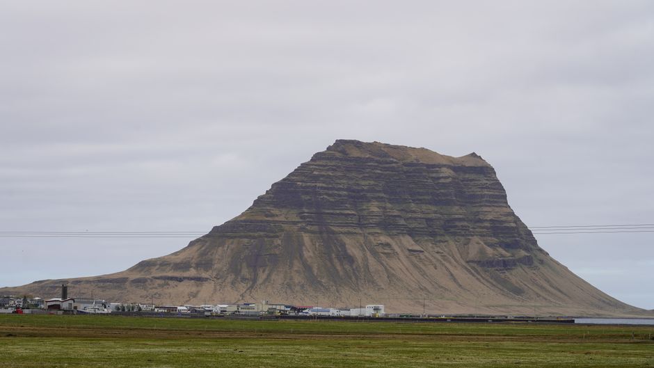
The Snæfellsnes peninsula juts about 90 km into the Atlantic north-west of Reykjavík, and it is often called “Iceland in miniature”: in one or two days you see a glacier-capped volcano, lava fields, black and golden beaches, sea cliffs full of birds, basalt columns, seals and small fishing towns. At its tip, the cone of Snæfellsjökull, the setting for Jules Verne’s Journey to the Centre of the Earth, rises over Snæfellsjökull National Park. On the north coast stands Kirkjufell, the steep, arrow-shaped mountain that is one of the most photographed in Iceland, and the harbour town of Stykkishólmur looks out over the hundreds of islands of Breiðafjörður. Snæfellsnes is about two and a half hours from Reykjavík, quieter than the south coast, and open all year. Give it two days, or one long day if you must.
Right now in Snæfellsnes (Grundarfjörður)
- Wed 4–6°C 39–43°F 2 mm Rain
- Thu 4–8°C 40–46°F 11 mm Rain
- Fri 4–6°C 40–44°F 1 mm Cloudy
Weather: MET Norway (CC BY 4.0) · Sea temperature: NOAA CoastWatch · Rates: ECB
Top tours in Snæfellsnes
See all tours for Snæfellsnes →
From local operators, with prices and reviews; you check availability and book on Viator, our partner. We may earn a commission at no extra cost to you. How we earn money
Snæfellsnes at a glance
- Best for: varied coastal scenery in a short trip: Kirkjufell, the cliffs of Arnarstapi and Hellnar, black-sand beaches, the Snæfellsjökull glacier, lava caves, seals and seabirds, and island boat trips from Stykkishólmur.
- How long: one long day from Reykjavík for the highlights; two days to drive the loop slowly with walks and a night on the peninsula; three with a boat trip or the Baldur ferry to the Westfjords.
- Best time: June to August for long days, birds and seals; September to April for the Northern Lights over Kirkjufell and snowy scenery, with short days and some winter storms.
- Getting in: by car from Reykjavík via Borgarnes, about 190 km and 2.5 hours to Arnarstapi or Stykkishólmur; by day tour; or by Strætó bus via Borgarnes (infrequent).
- Getting around: the loop road around the peninsula (Routes 54 and 574) is paved; a car or tour is needed to reach the sights.
- Budget: most sights are free. As of October 2026, Snæfellsjökull National Park charges a service fee with parking (ISK 1,100 a car for the day), and the car park at Kirkjufellsfoss is paid.
Snæfellsnes, coast by coast
The peninsula lies in West Iceland, mostly in the municipalities of Snæfellsbær, Grundarfjörður, Stykkishólmur and Eyja- og Miklaholtshreppur. A mountain spine runs down the middle, so there are two coasts with different characters, joined at the western tip around the glacier.
- The south coast: long golden and black beaches, lava fields and farms, from the Gerðuberg basalt cliffs and the Eldborg crater to Ytri Tunga’s seals, the black church at Búðir, and the cliffs of Arnarstapi and Hellnar.
- The western tip (Snæfellsjökull National Park): the glacier, the lava fields and sea stacks of Lóndrangar, Djúpalónssandur beach, the Vatnshellir lava cave, Saxhóll crater and the golden Skarðsvík beach.
- The north coast: fishing towns tucked under steep mountains: Hellissandur and Rif, Ólafsvík, Grundarfjörður with Kirkjufell, the Bjarnarhöfn shark farm and Stykkishólmur on Breiðafjörður.
Top things to see on Snæfellsnes
Kirkjufell and Kirkjufellsfoss
Kirkjufell (“Church Mountain”), 463 m high, stands alone on the shore just west of Grundarfjörður. The classic view is from across the road, with the small Kirkjufellsfoss waterfall in front, especially at sunset or under the Northern Lights. A short path leads from the car park to the falls and over a footbridge; it gets icy in winter. The main car park is paid by number-plate camera (pay at the machine or by app the same day). Climbing Kirkjufell itself is steep, exposed and slippery, and several people have died on it; local guides advise against trying it without one, and never in wet or icy conditions.
Arnarstapi and Hellnar
Arnarstapi is a tiny harbour village on the south coast below the glacier, surrounded by basalt cliffs, sea caves and natural arches such as Gatklettur, with kittiwakes and fulmars nesting on the ledges in summer. A large stone statue of Bárður Snæfellsás, the half-troll guardian spirit of the glacier, stands by the car park. A coastal path of about 2.5 km follows the lava cliffs to Hellnar, a hamlet with a small café by the cave of Baðstofa; walk it one way and back, about an hour each way with stops. The whole coastline here is a nature reserve, so stay on the path and away from the cliff edges, which can be undercut.
Snæfellsjökull National Park and the glacier
Snæfellsjökull National Park covers the western tip of the peninsula, from the glacier down to the sea. Snæfellsjökull is a stratovolcano about 1,446 m high, capped by a shrinking glacier; on a clear day you can see it from Reykjavík, more than 100 km away across Faxaflói bay. Roads 570 and F575 lead towards the glacier, but they are not open all year and F575 is for 4x4s only; the park recommends a guided tour (by snowcat or on foot with crampons) if you want to go onto the ice. The park has two visitor centres: the National Park Centre in Hellissandur, with exhibitions, a shop and a restaurant, and a smaller visitor centre at Malarrif near Lóndrangar. Both open every day, roughly from 10:00 to 16:30 (check the park’s website for the season), and their toilets are open 24 hours.
Since 6 August 2026, the park has charged a single service fee, paid together with parking at its car parks, to cover rangers, toilets, rubbish and paths. As of October 2026, it is ISK 1,100 for a car with up to five seats and ISK 450 for a motorbike, valid until midnight throughout the whole park.
Djúpalónssandur and Dritvík
A short path from the car park winds through twisted lava to Djúpalónssandur, a cove of black pebbles polished smooth by the sea. Rusted pieces of the British trawler Epine, wrecked here in 1948, lie on the beach as a memorial. By the path are four lifting stones, from the 23 kg Amlóði (“weakling”) to the 154 kg Fullsterkur (“full strength”), once used to test whether fishermen were strong enough to row. A trail continues over the headland to Dritvík, once a busy fishing station. The waves here are powerful and unpredictable: don’t go near the water’s edge. In summer there are toilets at the car park.
Lóndrangar, Vatnshellir and Saxhóll
The Lóndrangar basalt sea stacks, 75 m and 61 m high, are the remains of an old volcanic crater, with a viewing platform near Malarrif lighthouse. Vatnshellir is an 8,000-year-old lava tube that can only be visited on a guided tour: as of October 2026, Summit Adventure Guides runs 45-minute tours all year for ISK 5,900 for adults, ISK 4,600 for seniors and students and ISK 2,600 for teenagers, with children aged 5–11 free (minimum age 5). Helmets and torches are provided; spiral stairs lead down about 35 m. On the north side, a staircase climbs the Saxhóll crater for a wide view over the lava to the sea.
Búðir and the south coast
Búðir is an abandoned trading post on the edge of the Búðahraun lava field, where the small black wooden church, Búðakirkja, stands alone with the glacier behind. The present church dates from the mid-19th century and was rebuilt in the 1980s; it is often locked, but the setting is the point. Further east, Ytri Tunga is a golden beach where harbour and grey seals often lie on the rocks, best from June to August at low tide. The narrow Rauðfeldsgjá gorge, near Arnarstapi, can be entered a short way along the stream. Gerðuberg, by Route 54, is a long wall of tall basalt columns, and the Eldborg crater rises from a lava field near the start of the peninsula.
Stykkishólmur and Breiðafjörður
Stykkishólmur, the largest town on the peninsula, has a harbour full of fishing boats, old timber houses and good seafood, especially scallops and mussels from Breiðafjörður. Climb the basalt island of Súgandisey, joined to the harbour by a causeway, for the view from its little orange lighthouse over the bay’s countless islands. The Library of Water (Vatnasafn), an installation by the artist Roni Horn, holds columns of glacial meltwater in a former library on the hill, and the modern church looks like a whale’s spine. In summer, boat tours sail among the islands to see puffins, sea eagles and seals, often with shellfish fished and eaten on board, and the Baldur ferry calls at Flatey, a car-free island with old houses.
Bjarnarhöfn Shark Museum
On a farm between Grundarfjörður and Stykkishólmur, the Bjarnarhöfn family has cured Greenland shark for generations. The small museum explains how the poisonous fresh meat is fermented and hung to dry for months to make hákarl, and you can taste a cube with rye bread and, if you are brave, a shot of brennivín. The drying shed is next door.
Nature
- Gerðuberg
- Kirkjufellsfoss
- Lóndrangar
Peaks and mountains
- Kirkjufell
Churches and cathedrals
- Búðir Church (the Black Church)
Protected areas
- Snæfellsjökull National Park
Beaches
- Djúpalónssandur Beach
Hiking, beaches and boat trips
- Hiking: the Arnarstapi–Hellnar coastal path, the walk from Djúpalónssandur to Dritvík, Saxhóll crater, the trails of Snæfellsjökull National Park (the park publishes a walking map), and in summer guided glacier walks on Snæfellsjökull.
- Beaches: golden Skarðsvík and Ytri Tunga, black-pebbled Djúpalónssandur and the long sands of Löngufjörur on the south coast. They are for walking and wildlife, not swimming: the sea is cold and the currents strong.
- Boat trips: Breiðafjörður island tours from Stykkishólmur in summer, the Baldur ferry to Flatey and the Westfjords all year, and whale watching from Ólafsvík or Grundarfjörður in some seasons, when orcas follow the herring.
- Horse riding: farms on the south coast offer rides along the beaches, including the long tidal sands of Löngufjörur.
- Birdwatching: kittiwakes and fulmars at Arnarstapi, Arctic terns around Hellissandur and Rif (they dive at your head in nesting season), and sea eagles and puffins on the islands of Breiðafjörður.
Activities and best months
- Beaches and swimmingDjúpalónssandur is known for its black oval pebbles, the 'pearls of Djúpalón', the four lifting stones (Steinatök, 23-154 kg) once used to test fishermen's strength, and iron wreckage of the English trawler Epine GY-7, which ran aground in March 1948; there are car parks, toilets and a wheelchair-accessible viewing platform. Heavy surf with a strong undertow makes the shore dangerous: a beach to walk, not to swim. · source
- Boat tripsFrom Stykkishólmur, Seatours' Viking Sushi tours cruise among the islands of Breiðafjörður for birdlife, rock formations and the seabed ecosystem, hauling up scallops and sea urchins to taste on board the 140-seat Særún. The Baldur car ferry sails Stykkishólmur-Flatey-Brjánslækur (Westfjords); in the winter timetable, 1 September-31 December 2026, it runs every day except Saturday, calls at Flatey on Tuesdays, Fridays and Sundays (book ahead to get off there) and does not sail on 24-25 and 31 December or 1 January. · source
- HikingSnæfellsjökull National Park lists more than 37 hiking routes: the coastal path between Arnarstapi and Hellnar (2.5 km, about 1 hour, 'demanding'), Djúpalónssandur to Dritvík (1 km, 20 minutes), Saxhóll-Bárðarkista (5 km return, 3-4 hours, hard), easy walks such as Eyrahringur (3 km, 2 hours) and a 3-5 hour hard ascent of the Snæfellsjökull glacier. · source
Seasons, light and the 2026 eclipse
- Summer (June to August): almost 24-hour daylight in June, nesting birds on the cliffs, seals on the beaches and boat trips running. The busiest season, though still much quieter than the south coast.
- Autumn and spring: fewer visitors, dramatic light and the first or last Northern Lights. Some boat trips stop from September.
- Winter (November to March): Kirkjufell under snow and the aurora on clear nights, but only four to five hours of daylight in December, icy paths, and storms that can close the passes over the peninsula’s spine (Vatnaleið on Route 56 and Fróðárheiði on Route 570 are the most exposed). The coastal loop road is usually kept open.
- The 2026 eclipse: on 12 August 2026, western Iceland was in the path of a total solar eclipse, and Snæfellsnes was one of the best places to watch it. Thousands of visitors came, and the national park reported that the day went well. It was a once-in-a-lifetime event; the peninsula’s midsummer sunsets come round every year.
Day trips and nearby places
On the way from Reykjavík, the Borgarfjörður area has the Settlement Centre in Borgarnes, the Hraunfossar and Barnafoss waterfalls, Europe’s most powerful hot spring at Deildartunguhver with the Krauma baths, and the Víðgelmir lava cave. Grábrók, a crater right by the Ring Road north of Borgarnes, has a staircase to the rim. From Stykkishólmur, the Baldur ferry crosses Breiðafjörður to Brjánslækur in the Westfjords, a good start for the Látrabjarg bird cliffs and the Rauðasandur beach; on the way back south, the road via Búðardalur passes Eiríksstaðir, the reconstructed farm of Erik the Red.
Nearby destinations
- Reykjavík97 km
- Golden Circle131 km
- Vatnajökull National Park293 km
Getting there and getting around
By car or tour
From Reykjavík, drive north on the Ring Road through the Hvalfjörður tunnel (toll-free since 2018) to Borgarnes, about an hour, then west on Route 54 along the south coast of the peninsula. Arnarstapi is about 190 km from Reykjavík and Stykkishólmur about 170 km, each about two and a half hours. The loop around the western tip (Route 574) and along the north coast is paved; the shortcut over the middle via Route 56 (Vatnaleið) connects the south coast with Stykkishólmur and Grundarfjörður. A full loop from Reykjavík and back is about 500 km. Since 1 January 2026, hire cars carry Iceland’s kilometre fee of ISK 6.95 per km, so that adds about ISK 3,500. Fuel is available in Borgarnes, Ólafsvík, Grundarfjörður, Stykkishólmur and Hellissandur; there is little on the south coast of the peninsula. Day tours from Reykjavík run all year and take about 11–12 hours.
By bus
Strætó’s long-distance buses link Reykjavík (Mjódd) with Borgarnes, with connections to Stykkishólmur and along the north coast towns of the peninsula. Services run only a few times a day, less in winter and at weekends, and don’t reach the national park sights, so they suit a stay in Stykkishólmur or Grundarfjörður better than sightseeing. Check the Strætó timetable before you plan around it.
The Baldur ferry to the Westfjords
The car ferry Baldur, run by Ferjuleiðir, sails from Stykkishólmur across Breiðafjörður to Brjánslækur in the Westfjords, with stops at Flatey island, in about two and a half to three hours. In the winter season (1 September to 31 December 2026), it sails every day except Saturday, with afternoon sailings only on Mondays and Wednesdays and more on other days; it stops at Flatey three days a week, and you must book ahead to get off there. It does not sail on 24–25 December or 31 December–1 January. As of October 2026, winter one-way fares (valid 1 September 2026 to 31 May 2027) are ISK 6,300 for adults between Stykkishólmur and Brjánslækur, ISK 5,020 for seniors (67+), ISK 3,150 for ages 12–17 and free for children under 12 with their parents, plus ISK 6,300 for a standard car up to 5 m. Stykkishólmur to Flatey costs ISK 4,320 for adults. Summer fares are higher. Book a car space ahead in summer, and check the timetable on ferja.is, as the operator may change schedules.
When to go and how long to stay
Snæfellsnes has a cool, windy maritime climate, a little drier than Reykjavík on the north coast but wetter and stormier around the glacier. The table uses the Icelandic Met Office’s official 1991–2020 climate normals, as submitted to the World Meteorological Organization, for Stykkishólmur, which has one of the longest weather records in Iceland.
| Season | Average high | Average low | Rain or snow per month | Wet days per month | What it’s like |
|---|---|---|---|---|---|
| Winter (Dec–Feb) | 3 °C | −2 °C | 81–85 mm | 14 | Short days, storms and snow on the passes; Northern Lights over Kirkjufell |
| Spring (Mar–May) | 3 °C rising to 9 °C | −2 °C rising to 3 °C | 73 falling to 40 mm | 9–13 | Birds return to the cliffs; snow lingers on the glacier and passes |
| Summer (Jun–Aug) | 12–14 °C | 6–8 °C | 32–51 mm | 7–10 | The driest and lightest season; seals, seabirds and boat trips |
| Autumn (Sep–Nov) | 11 °C falling to 4 °C | 6 °C falling to 0 °C | 68–78 mm | 12–13 | Autumn storms, the first aurora, quiet roads |
Stykkishólmur gets about 740 mm of rain and snow a year on about 135 days, with June and July the driest months (about 32–34 mm each). July is the warmest month, with an average high of 13.9 °C. The western tip around the glacier is often windier and wetter, so check vedur.is and the road map on umferdin.is before crossing the passes.
Snæfellsnes in 1 day
Leave Reykjavík early. Stop at Gerðuberg and Ytri Tunga, then Búðir, Arnarstapi (walk part of the path to Hellnar), Lóndrangar and Djúpalónssandur. Continue round the tip past Saxhóll and Hellissandur, then along the north coast to Kirkjufell at sunset, and drive back via Route 56 and Borgarnes. It is a long day of about 500 km; in winter, cut the list to fit the daylight.
Snæfellsnes in 2 days
Day 1: the south coast and the national park, with the full Arnarstapi–Hellnar walk, Vatnshellir cave and Djúpalónssandur, ending with a night in Grundarfjörður or Hellissandur (and Kirkjufell by night if the aurora is out). Day 2: Kirkjufell in the morning, Bjarnarhöfn, then Stykkishólmur for lunch, Súgandisey and the Library of Water, a summer boat trip in Breiðafjörður, and either the drive back to Reykjavík or the Baldur ferry to the Westfjords.
Weather month by month
Averages from IMO normals 1991–2020, Stykkishólmur · Last reviewed 4 Oct 2026
Where to stay on Snæfellsnes
- Stykkishólmur: the most hotels, guesthouses and restaurants, and the Baldur ferry.
- Grundarfjörður: next to Kirkjufell, ideal for sunrise, sunset and Northern Lights photography.
- Hellissandur, Rif and Ólafsvík: close to the national park, with guesthouses and small hotels.
- Arnarstapi, Hellnar and Búðir: a few country hotels and cottages on the south coast, in beautiful settings under the glacier; book early.
- Campsites: in most towns, mainly from May to September.
Hotels and guesthouses add Iceland’s accommodation tax of ISK 800 per room per night (ISK 400 per campsite pitch).
Practical tips for Snæfellsnes
- Pay parking the same day: the national park and Kirkjufellsfoss use number-plate cameras; pay at the machine or online before midnight, or your hire company will add a fee.
- Stay off the edges: the cliffs at Arnarstapi and the beach at Djúpalónssandur are dangerous in big seas; keep back from the edge and the waterline.
- Watch for terns: in June and July, Arctic terns nesting near Hellissandur and Rif dive at walkers’ heads; a hat helps.
- Don’t stop on the road: use pull-outs and car parks for photos of Kirkjufell and Búðir.
- Check the passes: in winter, Route 56 (Vatnaleið) and Route 570 can be closed or icy; the coastal loop is safer. Use umferdin.is and vedur.is, and call 112 in an emergency.
What to pack for Snæfellsnes
Bring a windproof, waterproof rain jacket, warm layers, a hat and gloves even in summer, and sturdy hiking shoes with good grip for lava paths and wet rocks. In winter, add thermal layers, an insulated jacket, warm boots and ice grips for the paths at Kirkjufellsfoss and Djúpalónssandur, and a head torch and tripod for the Northern Lights. Binoculars are useful for seals and birds. Iceland uses type C and F plugs; see our travel adapters guide.
What to pack
- Day packs and anti-theft bagsCarries water, towel and sunscreen down the long stairways to Algarve coves.
- Dry bags and phone pouchesProtects phones and cameras from sand and spray on beaches reached by ferry or steep paths.
- Fleeces and warm layersIt is cooler at sea than on land, especially on morning whale-watching trips.
- HeadlampsLevada routes such as PR1 and PR9 pass through long, dark, wet tunnels.
- Hiking shoes and bootsMadeira's levadas and the Azores' crater rims are wet, rocky and slippery, so grippy shoes matter more than anywhere else in Portugal.
- Quick-dry beach towelsA sand-shedding quick-dry towel packs small for beach days and lido visits.
- Rain jacketsA windproof, waterproof shell keeps you warm on open boats, where wind and spray cool you quickly.
- Reef-friendly sunscreenSummer UV is strong on Portuguese beaches and there is little shade below the cliffs.
- Trekking polesLong stone staircases and steep descents on Madeira's peaks and the Azores' crater rims are easier on the knees with poles.
- Water bottles and hydration packsAlgarve and Alentejo trails are hot and exposed with few refill points.
- Water shoesRocky coves, lava pools and weever fish in shallow sand make water shoes useful.
- WetsuitsOn the west and north coasts the sea stays around 16–18 °C even in summer, so a thin suit helps for long swims.
Snæfellsnes travel FAQ
How far is Snæfellsnes from Reykjavík?
About 170–190 km, or two and a half hours’ drive, to Stykkishólmur or Arnarstapi via Borgarnes. A full loop of the peninsula from Reykjavík and back is about 500 km.
Can you do Snæfellsnes in one day?
Yes, by car or on a day tour of about 11–12 hours, covering Arnarstapi, Djúpalónssandur, Kirkjufell and a few other stops. Two days is much more relaxed and leaves time for walks, Vatnshellir and Stykkishólmur.
Is there a fee for Snæfellsjökull National Park?
Since 6 August 2026, the park has charged a service fee together with parking: as of October 2026, ISK 1,100 for a car with up to five seats and ISK 450 for a motorbike, valid until midnight throughout the park.
Do you have to pay to park at Kirkjufell?
Yes, the main car park at Kirkjufellsfoss is paid, using number-plate cameras, with payment at the machine or by app. Visitors report a day fee of about ISK 700–1,000. Don’t park on the road verge.
Can you climb Kirkjufell?
It is possible, but the route is steep, loose and exposed, and people have died on it. It is not a casual hike: go only with a local guide, in dry summer conditions, and never in wet, windy or icy weather.
How much is the Baldur ferry?
For the winter season from 1 September 2026 to 31 May 2027, one way between Stykkishólmur and Brjánslækur costs ISK 6,300 for an adult and ISK 6,300 for a standard car up to 5 m, as of October 2026. Children under 12 travel free with their parents. There are no sailings on Saturdays in winter.
Can you visit Vatnshellir cave without a guide?
No. Vatnshellir is protected and open only on guided tours, which run all year and last about 45 minutes. As of October 2026, tickets cost ISK 5,900 for adults; children must be at least 5.
Can you see the Northern Lights on Snæfellsnes?
Yes, from September to April on clear, dark nights. Kirkjufell is a famous aurora spot, and the whole peninsula has little light pollution. Check the aurora forecast on vedur.is and stay a night in Grundarfjörður or Hellissandur.
Is Snæfellsnes worth visiting in winter?
Yes, for snowy scenery, quiet roads and the aurora, but daylight is only about four to five hours in December and storms can close the mountain passes. Drive the coastal loop, check the roads each morning and keep the day plan short.
Where can you see seals on Snæfellsnes?
At Ytri Tunga beach on the south coast, where seals often rest on the rocks, especially in summer at low tide, and on boat trips around the islands of Breiðafjörður from Stykkishólmur. Keep your distance and keep quiet.
Sources
- © OpenStreetMap contributors · ODbL · fetched 4 Oct 2026
- Wikidata · CC0 · fetched 4 Oct 2026
Sources and last review
Researched and last reviewed on 4 October 2026. The national park’s service fee, visitor centres, glacier roads and toilets, and the 2026 eclipse: Snæfellsjökull National Park (snaefellsjokull.is); the Baldur ferry timetable and fares: Ferjuleiðir (ferja.is); Vatnshellir tours: Summit Adventure Guides; the kilometre fee: island.is; the accommodation tax: Skatturinn; climate: the Icelandic Met Office’s 1991–2020 normals for Stykkishólmur (WMO collection). The Kirkjufellsfoss parking fee, Kirkjufell climbing advice, the ferry crossing time, bus services, distances, and the heights and dates of Kirkjufell, Snæfellsjökull, Lóndrangar, Búðir church and the Epine wreck come from secondary sources or general knowledge and are flagged for checking. Prices, timetables and road conditions change, so check the official links before you go.
Plan your trip
Partner links: TravelerCenter may earn a commission if you book, at no extra cost to you.
🇮🇸 Useful Icelandic phrases for Snæfellsnes
All 38 Icelandic phrases: restaurant, hotel, emergencies, romance (printable) →