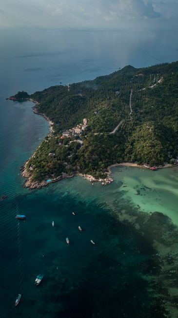
Ko Tao, “Turtle Island,” is a small, rugged island in the Gulf of Thailand, about 40 km (25 miles) north of Ko Pha Ngan and some 70 km (43 miles) off the mainland coast at Chumphon. Only about 21 km² (8 square miles) in size, it is one of the busiest places in the world to learn to scuba dive, with warm, clear water, dozens of shallow reefs and pinnacles close to shore, and a long tradition of dive schools on its main beach. Above water, Ko Tao has steep granite headlands, small coves with snorkeling straight off the beach, jungle viewpoints and a relaxed, outdoorsy atmosphere. Come to dive or snorkel at Ko Nang Yuan, Shark Bay and Chumphon Pinnacle, to hike to viewpoints, kayak between coves and enjoy sunsets on Sairee Beach. Like Ko Samui and Ko Pha Ngan, Ko Tao is driest from about January to August and wettest from October to December, when the northeast monsoon brings rough seas to its east coast.
Right now in Ko Tao (Mae Haad)
- Wed25–27°C77–81°F20 mm rain
- Thu25–27°C77–81°F4 mm rain
- Fri25–27°C78–81°F6 mm rain
Top tours in Ko Tao
See all tours for Ko Tao →
From local operators, with prices and reviews; you check availability and book on Viator, our partner. We may earn a commission at no extra cost to you. How we earn money
Ko Tao at a glance
- Best for: learning to dive and fun diving, snorkeling, hiking to viewpoints, kayaking, and a laid-back island stay.
- How long: 3–4 days for snorkeling and a few dives; 4–5 days for an Open Water course; a week or more for advanced courses.
- Best time: January to August for calm seas and sun, with highs of about 29–33 °C (84–91 °F); visibility is often best from about March to September.
- Getting there: high-speed catamaran from Chumphon on the mainland or from Ko Samui and Ko Pha Ngan, or a combined bus-and-boat ticket from Bangkok. There is no airport.
- Getting around: on foot around Sairee and Mae Haad, taxi pickups, rental scooters and ATVs on steep roads, and long-tail boats to the remote bays.
- Fees to know: Ko Nang Yuan, a private island, charges a landing fee, and some viewpoints on private land charge a small entry fee.
- Before you go: entry rules, the Thailand Digital Arrival Card, money and general safety are in our Thailand travel guide.
Ko Tao’s areas: where things are
Ko Tao is about 7 km (4 miles) long and 3 km (2 miles) wide. A paved road runs down the west side from Sairee through Mae Haad to Chalok Baan Kao; branches climb steeply over the hills to the east-coast bays, some of them on rough concrete or dirt tracks.
Sairee Beach
The island’s longest beach, about 1.7 km (1 mile) of sand on the west coast, lined with dive schools, guesthouses, bars and restaurants. The water is shallow and calm in the dry season, and sunsets here are a nightly event. It is the liveliest part of Ko Tao.
Mae Haad
The village around the main pier, with ferry offices, banks, clinics, shops and restaurants. It is convenient for arrivals and departures and a short walk to Sairee.
Chalok Baan Kao and the south
A sheltered bay in the south with a quieter village feel, several dive resorts and good restaurants. Nearby are Freedom Beach, the John-Suwan viewpoint and the snorkeling coves of Shark Bay and Sai Daeng.
The east coast: Tanote Bay and Aow Leuk
Small, rocky bays with excellent snorkeling, reached by steep roads. Tanote Bay is known for its jumping rock; Aow Leuk has a sandy beach and coral close to shore. Accommodation here is limited and peaceful.
The north: Mango Bay
A secluded bay at the northern tip, reached mainly by boat, with clear water and coral; it is a stop on many snorkeling tours.
Top things to see on Ko Tao
Ko Nang Yuan
Three small islands just off the northwest coast, joined by a curving sandbar, are Ko Tao’s most famous view. The islands are privately owned: visitors pay a landing fee, and plastic bottles, cans and fins on the coral are not allowed. Climb to the viewpoint for the classic picture, then snorkel the Japanese Gardens reef. Go early or late in the day to avoid the crowds from tour boats.
John-Suwan viewpoint
A short but steep climb from the road above Chalok Baan Kao leads to granite boulders with views over Shark Bay and Chalok Baan Kao on either side of the headland. A small fee is charged at the trailhead; wear proper shoes.
Shark Bay (Ao Thian Og)
A sheltered bay on the southeast coast where blacktip reef sharks are often seen in the shallows, especially in the early morning, along with turtles at times. Snorkel quietly and keep your distance.
Freedom Beach and Sai Daeng
Small coves in the south with good snorkeling and calm water. Sai Daeng looks out to the little island of Ko Sai Daeng and its shallow reef.
More viewpoints and coves
- Love Koh Tao and Mango viewpoints: high points in the north and center with panoramic views; the roads up are very steep.
- Tanote Bay: a rocky cove with a jumping rock and colorful reef fish.
- Hin Wong Bay: a quiet, boulder-strewn bay on the east coast for snorkeling.
- Sairee sunset: the west coast faces the sunset; beach bars put out cushions on the sand.
- Sairee Beach
Diving and snorkeling
Learning to dive
Ko Tao has dozens of dive schools, and thousands of people take their first course here every year; the Tourism Authority of Thailand chose the island in 2026 to showcase Thai diving under its partnership with PADI, the dive-training organization. A beginner (Open Water) course usually takes three to four days and combines theory, pool or shallow-water sessions and four open-water dives. The water is warm, many sites are shallow and sheltered, and prices are among the lowest in the world. Choose a shop for its safety record, small groups and well-maintained equipment rather than the cheapest price.
The main dive sites
- Chumphon Pinnacle: a granite pinnacle northwest of the island, with schools of fish, groupers and, in season, whale sharks; for more experienced divers.
- Sail Rock: a famous pinnacle between Ko Tao and Ko Pha Ngan with a vertical chimney swim-through; a full-day trip.
- Southwest Pinnacle: a cluster of pinnacles covered in anemones, with barracuda and trevally.
- White Rock and Twins: shallow, easy reefs off Sairee and Nang Yuan, used for training dives.
- HTMS Sattakut: a former navy ship sunk as an artificial reef off Sairee, at about 18–30 m (60–100 ft).
See our guide to diving.
Snorkeling
Ko Tao has some of the easiest snorkeling in Thailand: Ko Nang Yuan, Shark Bay, Tanote Bay, Aow Leuk and Mango Bay all have coral close to shore. Round-island boat tours stop at several of them in a day. Wear a rash guard and reef-safe sunscreen, and don’t touch or stand on coral. See our guide to snorkeling.
Activities and best months
- Scuba divingTAT's 2026 partnership with PADI features Ko Tao; Thailand was the second-largest country for PADI certifications in 2025.
Other things to do on Ko Tao
Food and drink
For a tiny island, Ko Tao eats well: Thai curries, pad kra pao and noodle soups at simple local restaurants in Mae Haad, fresh grilled fish on the beach in the evening, and plenty of bakeries and international cafés around Sairee. The night markets and street stalls near the pier are cheapest. Try khanom chin (rice noodles with curry) at local breakfast spots and fresh coconut ice cream.
Hiking, kayaking and climbing
Trails link the viewpoints and bays, and kayaks and paddleboards can be rented on most beaches to paddle around the headlands. Ko Tao also has granite boulders for rock climbing, with local guides offering beginner sessions.
Freediving and wellness
Freediving schools teach breath-hold courses in the deep, calm water off the west coast, and yoga studios and Thai massage are easy to find around Sairee and Chalok Baan Kao.
Festivals
Songkran in mid-April brings water fights to Sairee and Mae Haad, and on Loy Krathong (November 24 in 2026) people float krathongs at the beaches and the pier.
Day trips from Ko Tao
- Ko Nang Yuan: a short boat ride for the viewpoint, the sandbar and snorkeling.
- Round-island snorkeling tour: a full or half day by long-tail or speedboat around the bays.
- Sail Rock: a full-day dive trip for certified divers.
- Ko Pha Ngan: beaches, waterfalls and the Thong Sala market, about an hour or more by catamaran; see our Ko Pha Ngan guide.
- Ko Samui: the Big Buddha and Fisherman’s Village, about 1.5–2 hours by catamaran; see our Ko Samui guide.
- Ang Thong Marine National Park: a long day trip by speedboat from December 16 to October 31; the park closes every year from November 1 to December 15.
Nearby destinations
- Ko Pha Ngan44 km
- Ko Samui68 km
- Khao Lak239 km
- Ao Nang (Krabi)254 km
- Hua Hin276 km
- Phuket285 km
- Ko Phi Phi287 km
- Ko Lanta289 km
Getting there and getting around
From the mainland: Chumphon
The quickest route from Bangkok is via Chumphon, on the mainland coast west of Ko Tao. Fly to Chumphon Airport (CJM) or take a State Railway of Thailand train or a bus to Chumphon, then a Lomprayah catamaran (about 1.5–2 hours) or another operator’s boat to Mae Haad pier. Lomprayah sells joint tickets from Bangkok (Khao San Road and Pinklao) with buses leaving at about 06:00 and from 21:00 to 22:00, and from Chumphon Airport and station. A slow overnight boat also runs from Chumphon in some seasons.
From Ko Samui, Ko Pha Ngan and Surat Thani
Lomprayah runs about seven catamarans a day from Ko Pha Ngan to Ko Tao and three from Ko Samui’s Pralarn pier in Maenam (08:00, 11:00 and 12:30 in its October 2026 timetable), with three returns to Samui. Seatran Discovery connects Mae Haad with Thong Sala on Ko Pha Ngan, Bang Rak and Nathon on Samui, and Don Sak and Surat Thani on the mainland. You can fly to Ko Samui (USM) or Surat Thani (URT) and continue by boat. Sailings may be canceled in rough weather, mainly from October to December.
Around the island
Taxi pickups wait at Mae Haad pier and charge fixed fares by destination. Sairee and Mae Haad are walkable, and many dive schools include transfers. Scooters and ATVs are widely rented, but Ko Tao’s roads are very steep, narrow and often sandy, and you need a motorcycle license, an International Driving Permit and a helmet. Long-tail boats and water taxis reach the bays without good roads.
When to go and how long to stay
Ko Tao lies in the Gulf of Thailand, sheltered from the southwest monsoon that soaks Phuket from May to October; its rainy season comes with the northeast monsoon. There is no long-term weather station on the island, so the table uses the 1991–2020 normals of the Thai Meteorological Department (TMD) for its Ko Samui station, about 70 km (43 miles) to the south, as submitted to the World Meteorological Organization (WMO): average daily highs and lows, total rain, and days with at least 1 mm of rain. Ko Tao’s weather follows the same pattern.
| Month | Average high / low | Rain (days with 1 mm or more) | What to expect |
|---|---|---|---|
| January | 29 °C (84 °F) / 24 °C (76 °F) | 127 mm (5.0 in), 8 days | Drying out; some windy days and choppy crossings |
| February | 29 °C (85 °F) / 25 °C (77 °F) | 64 mm (2.5 in), 4 days | Sunny and calm; one of the best months |
| March | 30 °C (87 °F) / 25 °C (78 °F) | 116 mm (4.6 in), 5 days | Mostly dry; visibility improves; whale shark season begins |
| April | 32 °C (89 °F) / 26 °C (79 °F) | 83 mm (3.3 in), 6 days | Hot and calm; Songkran water festival |
| May | 33 °C (91 °F) / 26 °C (78 °F) | 132 mm (5.2 in), 11 days | The hottest month; calm seas |
| June | 33 °C (91 °F) / 25 °C (78 °F) | 134 mm (5.3 in), 10 days | Good diving; a fine choice when the Andaman coast is wet |
| July | 32 °C (90 °F) / 25 °C (77 °F) | 117 mm (4.6 in), 11 days | Busy summer holidays; book courses ahead |
| August | 32 °C (90 °F) / 25 °C (77 °F) | 102 mm (4.0 in), 10 days | Mostly fine; often clear water |
| September | 32 °C (89 °F) / 25 °C (77 °F) | 118 mm (4.6 in), 11 days | Showers increase; quieter and cheaper |
| October | 31 °C (87 °F) / 24 °C (76 °F) | 295 mm (11.6 in), 16 days | Northeast monsoon rains begin |
| November | 30 °C (85 °F) / 24 °C (75 °F) | 445 mm (17.5 in), 16 days | The wettest month; rough seas; some boats canceled |
| December | 29 °C (85 °F) / 24 °C (75 °F) | 263 mm (10.4 in), 12 days | Wet and windy early on, improving towards New Year |
About 1,990 mm (79 in) of rain falls a year at the Samui station, more than half of it from October to December, when strong winds can stir up the water, cut visibility and cancel crossings. From January to September Ko Tao is mostly sunny, and dive conditions are usually good.
Weather month by month
3 days on Ko Tao
Day one, Sairee Beach and a sunset drink. Day two, a round-island snorkeling trip with Ko Nang Yuan, Mango Bay and Shark Bay, or two fun dives. Day three, the John-Suwan viewpoint and Freedom Beach in the morning, and kayaking or an afternoon at Tanote Bay.
5 days or more
Take a four-day Open Water course and spend the last day snorkeling or relaxing, or add advanced courses, freediving or a few days on Ko Pha Ngan.
Where to stay on Ko Tao
- Sairee Beach: the most choice, the dive schools and nightlife, and the sunset.
- Mae Haad: convenient for the pier and restaurants; good for short stays.
- Chalok Baan Kao: quieter, with dive resorts and a village feel.
- Tanote Bay and Aow Leuk: for snorkeling from your doorstep and peace, but far from shops.
- Hillside resorts and villas: sea views and privacy; check how steep the access road is.
Many dive schools offer discounted or free rooms during a course. Rates are highest from late December to April and in July and August.
What a trip to Ko Tao costs
Prices are approximate, for October 2026, converted at about 33 baht to the US dollar.
| Item | Typical cost |
|---|---|
| Street food or local dish | 60–120 baht (about US$1.80–3.60) |
| Dinner for two at a beach restaurant | 800–2,000 baht (about US$24–60) |
| Catamaran from Chumphon or Ko Samui | 600–800 baht (about US$18–24) |
| Taxi pickup from Mae Haad to Sairee or Chalok | 100–300 baht (about US$3–9) |
| Round-island snorkeling tour | 700–1,200 baht (about US$21–36) |
| Open Water dive course | 11,000–14,000 baht (about US$330–425) |
| Fun dive, per dive | 800–1,200 baht (about US$24–36) |
| Mid-range room double | 1,500–4,000 baht (about US$45–120) |
Practical tips for Ko Tao
- Choosing a dive school: ask about group size, instructor certification, equipment checks and emergency oxygen; read recent reviews.
- Cash: ATMs are in Mae Haad, Sairee and Chalok, but carry cash for taxis and small bars.
- Water: buy refillable water where available; Ko Tao has limited fresh water and waste is shipped off the island.
- Boats and weather: from October to December, leave a buffer day before an international flight.
- Cannabis and vaping: cannabis flower needs a Thai prescription, and e-cigarettes are illegal in Thailand.
- Help: the Tourist Police (1155) speak English, and the TAT Contact Center (1672) answers tourist questions.
Safety
Ko Tao is easygoing and friendly; most accidents happen on the roads and in the water.
- Diving safety: dive within your training and certification, check your equipment, and don’t dive with a cold or after drinking. Leave at least 18–24 hours between your last dive and a flight. Ko Tao has clinics rather than a full hospital, so serious cases are transferred to Ko Samui or the mainland; make sure your travel insurance covers diving.
- Sea conditions: from about October to January, the northeast monsoon brings waves and currents to the east-coast bays; snorkel in sheltered water, and watch for boat traffic, especially at Ko Nang Yuan and Shark Bay.
- Jellyfish: the Tourism Authority of Thailand lists Ko Tao among the places where box jellyfish are occasionally reported, mainly in the rainy season; pour vinegar on a sting for at least 30 seconds and call 1669.
- Road safety: the island’s roads are very steep, narrow and often sandy, and scooter and ATV crashes are the most common injury. Wear a helmet, walk or take a taxi to the steepest bays, and never ride after drinking.
- Hiking: viewpoint trails are steep and rocky; bring water and good shoes, and come down before dark.
- Nightlife: keep an eye on your drink and belongings, and don’t swim at night.
- Emergencies: call 1155 for the Tourist Police (English spoken), 191 for the police and 1669 for an ambulance.
What to pack for Ko Tao
Swimwear and a rash guard, reef-safe sunscreen, a mask and snorkel if you have your own, sandals and sturdy shoes for the viewpoint trails, a dry bag for boat trips, a headlamp, a light rain jacket from October to December, and your dive certification card and logbook. Thailand uses 220 V; sockets take both flat two-pin and round two-pin plugs.
What to pack
- Dry bags and phone pouchesDive boats are wet; keep phone, documents and a towel dry between dives.
- Fleeces and warm layersA warm layer or windproof after a dive stops you chilling on the boat ride back.
Ko Tao travel FAQ
Is Ko Tao good for beginners learning to dive?
Yes. It is one of the world’s most popular places for a first course, with many shallow, sheltered sites and competitive prices. An Open Water course takes three to four days.
When is the best time to visit Ko Tao?
From January to August, and especially February to August for calm seas. October to December is the wettest period.
How do I get to Ko Tao?
By high-speed catamaran from Chumphon on the mainland (about 1.5–2 hours) or from Ko Samui and Ko Pha Ngan. Combined bus-and-boat tickets run from Bangkok, and you can fly to Chumphon or Ko Samui.
Can I see whale sharks on Ko Tao?
They are seen in some years at Chumphon Pinnacle and Sail Rock, most often from about March to May and again around September and October, but sightings are never guaranteed.
Do I have to pay to visit Ko Nang Yuan?
Yes, the islands are privately owned and charge a landing fee; plastic bottles and cans are not allowed.
Where can I snorkel from the beach on Ko Tao?
Shark Bay, Tanote Bay, Aow Leuk, Sai Daeng and Freedom Beach all have coral close to shore.
Is Ko Tao good for families?
Yes, for families who like the water: there is easy snorkeling, kids’ dive programs from age 8 or 10, and quiet bays. The steep roads and limited medical facilities are worth bearing in mind.
Do I need a scooter on Ko Tao?
No. Sairee and Mae Haad are walkable, and taxis go everywhere; the roads are steep and best left to experienced riders.
How many days should I spend on Ko Tao?
Three or four days for snorkeling and a few dives; five days or more for a dive course.
Is there an ATM on Ko Tao?
Yes, in Mae Haad, Sairee and Chalok Baan Kao, but carry some cash for taxis, boats and small businesses.
Plan your trip
Partner links: TravelerCenter may earn a commission if you book, at no extra cost to you.
🇹🇭 Useful Thai phrases for Ko Tao
All 38 Thai phrases: restaurant, hotel, emergencies, romance (printable) →
Sources · last reviewed 4 October 2026
Researched and last reviewed on 4 October 2026. Ferry routes and October 2026 timetables: Lomprayah and Seatran Discovery; Ang Thong closure dates: the Department of National Parks, Wildlife and Plant Conservation; the PADI partnership, jellyfish areas, cannabis and e-cigarette rules and the Tourist Police: the Tourism Authority of Thailand (TAT); climate normals: the Thai Meteorological Department via the World Meteorological Organization’s 1991–2020 normals; Loy Krathong date: the 12th-month full moon from the US Naval Observatory; exchange rate: the US Federal Reserve. Dive-site details, journey times, fees, course lengths and typical prices are general references or estimates, flagged for checking. Prices and schedules change, so check the official sites before you go. For entry rules, money and general safety, see our Thailand travel guide.
Also: tatnews.org · TMD normals 1991–2020, Ko Samui (climate)
Data: Weather: MET Norway (CC BY 4.0) · Sea temperature: NOAA CoastWatch · Rates: ECB · Costs: World Bank ICP and price levels · Wikidata (CC0)