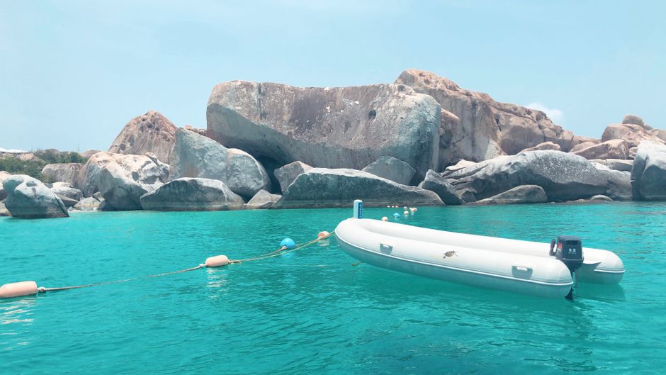
The British Virgin Islands (BVI) are a cluster of about 60 green, hilly islands and cays at the eastern end of the Greater Antilles, just east of the US Virgin Islands and about 100 km (60 miles) east of Puerto Rico. They are one of the world’s favorite places to sail: the islands sit close together around the sheltered Sir Francis Drake Channel, so you can hop from one calm anchorage to the next in a couple of hours, stopping at beach bars, reefs and coves. On land, the highlights are the giant granite boulders and pools of The Baths on Virgin Gorda, the beaches of Tortola and Jost Van Dyke, and flat, reef-ringed Anegada with its lobster and empty sands. The BVI are a British Overseas Territory, but the currency is the US dollar, and life is relaxed and small-scale, with no cruise-ship crowds outside Road Town. December to April is the classic season; hurricane season, from June to November, is quieter and cheaper.
Right now in British Virgin Islands
- Tue 27–29°C 81–84°F 10 mm Light showers
- Wed 26–29°C 79–84°F 11 mm Rain
- Thu 28–29°C 83–84°F 1 mm Light showers
Weather: MET Norway (CC BY 4.0)
Multi-day tours of British Virgin Islands
Multi-day tours from local operators. You check dates and book on Viator, our partner; we may earn a commission at no extra cost to you. How we earn money
British Virgin Islands at a glance: overview and geography
The territory’s land area is only about 153 km² (59 square miles), spread over four main islands and dozens of smaller ones. Tortola, the largest, holds the capital, Road Town, the main airport on its linked islet of Beef Island, and most of the roughly 39,000 residents. Virgin Gorda lies to the east, Jost Van Dyke to the northwest, and Anegada, the only coral island in an archipelago of volcanic ones, about 25 km (15 miles) to the north. The highest point is Sage Mountain on Tortola, at 521 m (1,709 feet).
The Taíno and earlier peoples lived here before Columbus sighted the islands in 1493 and named them after the 11,000 virgins of the legend of Saint Ursula. Pirates and privateers used the anchorages; the Dutch settled Tortola in the 17th century, and the English took control in 1672. Sugar plantations worked by enslaved Africans were the economy until emancipation in 1834, celebrated every August in the Emancipation Festival. Today the BVI are a self-governing British Overseas Territory with a Premier and a Governor appointed by the UK, and their economy rests on tourism and international financial services. Hurricane Irma, a Category 5 hurricane, devastated the islands on 6 September 2017; most of the islands, hotels and marinas have been rebuilt since.
Time zone: the BVI are on Atlantic Standard Time (UTC−4) all year, with no daylight saving, the same as US Eastern Daylight Time in summer and one hour ahead of it in winter.
The islands and areas
- Tortola: Road Town’s harbor, marinas and shops; Cane Garden Bay, Brewers Bay, Smuggler’s Cove and Josiah’s Bay on the north and west coasts; Sage Mountain; West End’s ferry terminal and Soper’s Hole.
- Beef Island and the East End: the main airport, Trellis Bay with its arts village and full-moon parties, and Long Bay.
- Virgin Gorda: The Baths and Devil’s Bay, Spanish Town, Savannah Bay, Gorda Peak, and the North Sound, a sheltered bay of resorts and anchorages.
- Jost Van Dyke: White Bay and its beach bars, Great Harbour, and the small Sandy Cay and Sandy Spit nearby.
- Anegada: flat, quiet and ringed by the Horseshoe Reef, with long beaches such as Loblolly Bay and Cow Wreck Beach, salt ponds with flamingos, and lobster dinners.
- The southern islands: Norman, Peter, Cooper, Salt and Ginger Islands, with snorkeling caves, the wreck of the RMS Rhone, and small resorts.
Where to go: The Baths, the beaches and the out islands
Most visitors either charter a yacht or base themselves on Tortola or Virgin Gorda and take ferries and day sails to the rest. Choose Tortola for choice and easy transport, Virgin Gorda for The Baths and upscale resorts, Jost Van Dyke for beach bars and a laid-back feel, and Anegada for solitude.
The Baths, Virgin Gorda
The BVI’s most famous sight: huge granite boulders tumbled along the shore at the southwest tip of Virgin Gorda, forming sea pools, grottoes and passages lit by shafts of sunlight. A trail from the parking area leads down to Devil’s Bay; a second trail through the boulders involves crawling, ladders and wading, so wear grippy shoes. The area is part of The Greater Baths National Park, run by the National Parks Trust of the Virgin Islands, which charges a day pass. It is busiest from late morning, when charter boats and day trips arrive; go early.
Jost Van Dyke and White Bay
A small, hilly island with a big reputation, thanks to White Bay’s soft sand and beach bars, including the Soggy Dollar Bar, where the Painkiller cocktail was born and visitors traditionally swim ashore from their boats. Great Harbour has Foxy’s, a famous bar and the scene of New Year’s Eve parties. Ferries run from Tortola’s West End and from St. Thomas and St. John.
Anegada
The only flat coral island in the chain, barely 8.5 m (28 feet) high, surrounded by the Horseshoe Reef, one of the largest barrier reefs in the Caribbean, which has claimed hundreds of ships. Rent a car or scooter to reach Loblolly Bay and Cow Wreck Beach for snorkeling and empty sand, look for flamingos in the salt ponds, and eat grilled Anegada lobster. Reach it by ferry from Road Town or by small plane.
Norman Island, the Caves and the RMS Rhone
Norman Island, said to have inspired Treasure Island, has snorkeling caves at Treasure Point and a busy anchorage at the Bight. Nearby, the Indians are rock pinnacles with excellent snorkeling, and off Salt Island lies the wreck of the RMS Rhone, a mail steamer sunk in a hurricane in 1867, now the centerpiece of a national marine park and one of the Caribbean’s best dives.
Tortola’s beaches and Sage Mountain
Cane Garden Bay is Tortola’s best-known beach, with bars, water sports and calm water; Brewers Bay and Smuggler’s Cove are quieter, and Josiah’s Bay and Apple Bay draw surfers in winter. Sage Mountain National Park, the BVI’s first national park, protects the island’s highest forest, with trails and views over the islands. In Road Town, the J.R. O’Neal Botanic Gardens are a shady stop.
A few more worth your time
Cooper Island, with a small eco-resort and beach bar; Spanish Town and the old Copper Mine ruins on Virgin Gorda; Gorda Peak National Park’s hike; the North Sound’s water sports and Saba Rock; Trellis Bay’s full-moon party with fireballs and music; and Sandy Spit, a tiny islet of sand and palm trees off Jost Van Dyke.
Best time to visit the British Virgin Islands
The BVI are warm and breezy all year, with steady trade winds, a drier season from about January to July and more rain from August to November. There are no official long-term averages for the BVI online, so the table uses the 1991–2020 normals for Charlotte Amalie, St. Thomas, about 25 km (15 miles) west of Tortola, from the World Meteorological Organization archive kept by NOAA. The BVI’s climate is very similar.
| Season (St. Thomas, 1991–2020) | Average high | Average low | Rain per month | Days with rain | What it’s like |
|---|---|---|---|---|---|
| Dec–Apr | 29–30 °C (84–86 °F) | 23–24 °C (74–76 °F) | 47–74 mm (1.9–2.9 in) | 7–12 | Peak season: sunny and breezy, with strong “Christmas winds” in December and January; the best sailing. |
| May–Jul | 31–32 °C (87–90 °F) | 25–26 °C (77–79 °F) | 60–77 mm (2.4–3.0 in) | 7–10 | Hot, calmer winds and clear water; good value after Easter. |
| Aug–Nov | 30–32 °C (87–90 °F) | 25–26 °C (77–79 °F) | 111–154 mm (4.4–6.1 in) | 11–14 | The wettest, most humid months and the peak of hurricane season; some resorts close in September and October. |
The sea is warm all year, from about 26 °C (79 °F) in February and March to 29 °C (84 °F) in September and October.
Hurricanes and sargassum
According to NOAA’s National Hurricane Center (NHC), the Atlantic hurricane season runs from 1 June to 30 November, with most activity between mid-August and mid-October. The BVI lie in the path of storms crossing from the Atlantic: Hurricane Irma struck as a Category 5 on 6 September 2017, and Hurricane Maria passed nearby two weeks later. As of 4 October 2026, the 2026 season had produced eight tropical storms and no hurricanes, and none had brought watches or warnings to the BVI, according to the NHC. If you travel from June to November, choose flexible bookings and insurance that covers hurricanes; charter companies have hurricane clauses. Sargassum seaweed drifts in mainly from about March to September and piles up on east- and south-facing bays, such as parts of Anegada, Beef Island and Virgin Gorda’s east coast, while the sheltered western bays are usually clearer. According to the University of South Florida’s Sargassum Watch, 2026 is at least the second-largest sargassum year on record, with record Caribbean amounts in June; by September amounts were falling and expected to keep falling until about November.
Crowds, prices and events
Mid-December to mid-April is peak season, with the highest hotel and charter rates; Christmas, New Year (with big parties on Jost Van Dyke) and Easter are busiest. The BVI Spring Regatta and Sailing Festival in late March or early April fills the marinas. Summer is quieter and cheaper, with calm seas, and the Emancipation Festival, the BVI’s biggest celebration, runs for about two weeks into early August. September and October are very quiet, and some businesses close.
How long to stay: sample itineraries
The BVI reward slow travel. A week is ideal, either on a charter yacht or split between two islands.
4 days: Tortola and Virgin Gorda
Day 1: Cane Garden Bay and sunset at Smuggler’s Cove. Day 2: ferry to Virgin Gorda for The Baths and Devil’s Bay, early. Day 3: a day sail to Norman Island, the Caves and the Indians. Day 4: Sage Mountain in the morning, then Trellis Bay.
7 days: a sailing charter
Road Town to Norman Island, the RMS Rhone and Cooper Island, Virgin Gorda’s Baths and the North Sound, Anegada (if the weather and your charter company allow), and Jost Van Dyke’s White Bay, ending at Cane Garden Bay. Charter companies give a full briefing, and skippered or crewed boats are available. See our boat trips guide.
10 days: BVI and USVI
Combine a week in the BVI with a few days on St. Thomas or St. John, a short ferry ride away; see our US Virgin Islands travel guide. Allow time for immigration on each crossing.
Entry, money, fees and costs
Entry rules and the online form (last reviewed October 2026)
The BVI set their own entry rules as a British Overseas Territory. You need a passport valid for your stay, a return or onward ticket, and proof of accommodation. US, Canadian, UK and EU citizens don’t need a visa for a tourist stay; nationals of countries on the BVI visa list may enter without one if they hold a valid visa for the UK, the US or Canada, according to BVI Tourism. US citizens returning by air need a passport.
- Online immigration and customs form: since 1 January 2025, the paper arrival form has been replaced by an online Immigration and Customs Form at bviedcard.gov.vg, which opens 72 hours before arrival. Save or print the receipt and show it on arrival, whether by air or sea.
- Environmental and Tourism Levy: according to the Government of the Virgin Islands, visitors pay a US$10 levy on arrival at all ports of entry, in force since 2017, to fund environmental protection and tourism sites.
- Departure tax: a departure tax is charged when you leave; it is usually included in air tickets, and ferry passengers pay it at the terminal.
- Yachts: all boats entering BVI waters must clear in with Customs and Immigration at a port of entry (Road Town, West End, Jost Van Dyke’s Great Harbour or Virgin Gorda) during office hours; private yachts can pre-register on SailClear. Charter yachts pay cruising permit fees, usually arranged by the charter company.
Rules change, so check BVI Tourism’s travel pages and the official form site shortly before you travel.
National parks, moorings and marine fees
The National Parks Trust of the Virgin Islands manages the territory’s land and marine parks, including The Baths, Sage Mountain, Gorda Peak and the RMS Rhone Marine Park.
- Park entry: the Greater Baths day pass, covering The Baths, Devil’s Bay, Stoney Bay and Spring Bay, costs US$3 for adults and US$2 for children (plus a small online booking fee), according to the Trust’s ticket page; Sage Mountain and the J.R. O’Neal Botanic Gardens also sell day passes.
- Marine Conservation Permit: boats that use the Trust’s moorings at dive and snorkel sites, such as the Caves, the Indians and the Rhone, need a Marine Conservation Permit, sold by the Trust online and processed within five business days; charter companies usually include it. The cost depends on the number of people on board.
- Mooring rules: the Trust’s moorings at dive and snorkel sites are for daytime use only, and anchoring on reefs is not allowed; overnight moorings in bays are run by private operators for a nightly fee.
Money, tipping and hotel taxes
The BVI use the US dollar, and US-issued cards work in hotels, restaurants and shops; carry cash for taxis, beach bars and small businesses, and note that some places add a fee for card payments. ATMs are in Road Town and a few other spots. According to the Government of the Virgin Islands, hotels and other short-stay accommodation charge a hotel accommodation tax of 10% of the room rate, raised from 7% in February 2017. Most hotels and many restaurants also add a service charge of about 10–15%; if it is on the bill, an extra tip is optional. Otherwise tip 15% in restaurants, and tip taxi drivers, guides and charter crews (crews commonly expect 15–20% of the charter fee).
Typical travel costs
The BVI are one of the more expensive Caribbean destinations: almost everything is imported, and many resorts are small and upscale. These estimates, per person per day, are a planning guide as of October 2026:
| Style | Estimated cost per day | What that looks like |
|---|---|---|
| Budget | about US$150–220 | Guesthouse or apartment on Tortola shared by two, cooking some meals, local restaurants, ferries rather than tours |
| Mid-range | about US$300–500 | Beach hotel or villa shared by two, restaurant meals, a hire car, a day sail and park fees, or a bareboat charter shared by a group |
| High-end | about US$800+ | Island resorts on Virgin Gorda or Peter Island, crewed yacht charters, private boat transfers |
Add the US$10 levy, the 10% accommodation tax and service charges, park passes and cruising fees. The figures are our estimates, not official statistics.
Getting there and getting around
Flights
The main airport is Terrance B. Lettsome International Airport (EIS) on Beef Island, linked to Tortola by a bridge. According to BVI Tourism, American Airlines flies nonstop from Miami, the only nonstop route from the US mainland. Other routes connect through San Juan (Cape Air, Silver Airways/Seaborne, Caribbean Airlines, and Tradewind Aviation from 19 December 2026 to 12 April 2027), St. Thomas, Antigua, Sint Maarten or Santo Domingo (interCaribbean). Virgin Gorda (VIJ) has flights from San Juan, and Anegada (NGD) is served by charter planes. There are no direct flights from Canada or Europe.
Ferries
Many visitors fly into St. Thomas and take a ferry: boats run from Charlotte Amalie and Red Hook on St. Thomas, and from Cruz Bay on St. John, to Road Town or West End on Tortola, with some sailings to Jost Van Dyke and Virgin Gorda. According to BVI Tourism, these ferries run only in daylight, with the last departures around 4:30–5 pm, so time your flight carefully. Within the BVI, ferries link Road Town and Beef Island with Virgin Gorda, West End with Jost Van Dyke, and Road Town with Anegada a few days a week. Bring your passport and online form receipt for every international crossing.
Driving and taxis
The BVI drive on the left, usually in left-hand-drive American cars. Roads on Tortola and Virgin Gorda are narrow, very steep and winding; drive slowly, and use first gear on descents. Rental companies issue a temporary BVI driving permit. Taxis use fixed rates set by the government for each route, often charged per person; confirm the fare first. Cruise passengers fill Road Town’s taxis on ship days.
Beaches, sailing and safety on the water
All beaches in the BVI are public up to the high-water mark, though access across private land may be limited. The western and northern bays are usually calm in summer, while north-facing beaches such as Josiah’s Bay and Apple Bay get surf from winter swells. See our beaches guide, plus snorkeling, diving and boat trips.
- No lifeguards: most beaches have no lifeguards; watch children and don’t swim after drinking.
- Boats: swim inside marked areas where buoys are set, and watch for dinghies in anchorages, especially at White Bay and Cane Garden Bay.
- Reefs: don’t stand on coral; wear water shoes on rocky entries and in The Baths, and watch for sea urchins.
- Sailing: charter companies limit where bareboats may go (for example, Anegada’s reef requires care and good light), and Customs clearance is needed whenever you leave or re-enter BVI waters.
- Swell days: The Baths and some north-shore snorkel sites can be closed to boats or unsafe in big swells; follow the National Parks Trust’s flags.
Safety, health and connectivity
Safety
The BVI have a low level of crime by regional standards. Most problems are petty theft from cars, boats and beaches, and occasional break-ins, so lock up dinghies and outboard motors, keep valuables out of sight, and don’t leave bags unattended. Take care on the steep roads at night and after drinking. Emergency number: 999 or 911 for police, fire and ambulance; the main hospital is the Dr. D. Orlando Smith Hospital in Road Town. Recompression facilities for divers are limited, so dive conservatively.
Health
Sunburn and dehydration are the most common complaints. Mosquito-borne diseases such as dengue occur in the region; use repellent. Water supplies come from desalination and household cisterns; many visitors drink bottled or filtered water. Travel insurance with medical evacuation cover is strongly recommended, as serious cases are flown to Puerto Rico or the US.
Accessibility
The islands are hilly, with steep roads and docks, and The Baths’ boulder trail is not accessible, though Devil’s Bay can be seen from the top trail. Some newer resorts and ferries have accessible facilities; ask before booking.
Connectivity and power
Mobile coverage is good on the main islands, with local providers Digicel, Flow and CCT selling prepaid SIM cards; some US plans include roaming, so check first. Wi-Fi is standard in hotels and at many bars. Electricity is 110 V at 60 Hz with US-style sockets, so North American visitors need no adapter, while others need a travel adapter.
Food, drink and culture
BVI food mixes Caribbean, British and American influences, with plenty of seafood: grilled Anegada lobster, conch fritters, fish or saltfish with fungi (a cornmeal side, considered the national dish), johnnycakes, roti, goat stew and pates (pastries filled with meat or fish). Beach bars serve the Painkiller, a mix of rum, pineapple and orange juice and coconut cream topped with nutmeg, created on Jost Van Dyke. Local music is fungi (or scratch) bands, played with homemade instruments, and the islands celebrate their heritage at the August Emancipation Festival. Dress is casual, but cover up away from the beach.
Things to do: sailing, diving, hiking and island hopping
- Sailing: bareboat or crewed charters from Road Town and Nanny Cay, day sails, and the Spring Regatta.
- Diving and snorkeling: the RMS Rhone, the Indians, the Caves, Painted Walls and Anegada’s reef.
- Hiking: Sage Mountain and Gorda Peak national parks. See our hiking guide.
- Surfing: Apple Bay and Josiah’s Bay in winter swells. See our surfing guide.
- Island hopping: ferries and day trips to Jost Van Dyke, Virgin Gorda and Anegada.
- Culture: the full-moon party at Trellis Bay, fungi bands, and the Emancipation Festival in August.
What to pack
Bring light clothes, swimwear, a sun hat that won’t blow away, sunglasses, high-factor reef-friendly sunscreen, a dry bag for boat days, snorkel gear if you have it, and water shoes for The Baths and rocky entries. Pack sturdy shoes for park trails, a light layer for windy evenings on deck, and a light rain jacket from August to November. Keep your passport and online-form receipt handy for every ferry crossing.
British Virgin Islands travel FAQ
Do I need a passport to visit the British Virgin Islands?
Yes. All visitors, including US citizens, need a passport. US, Canadian, UK and EU citizens don’t need a visa for a tourist stay.
What is the BVI online immigration form?
Since 1 January 2025, visitors fill in an online Immigration and Customs Form at bviedcard.gov.vg, available 72 hours before arrival, and show the receipt on arrival by air or sea.
Is there a tourist fee in the BVI?
Yes. Visitors pay a US$10 Environmental and Tourism Levy on arrival, and hotels charge a 10% accommodation tax, usually plus a service charge.
How much does it cost to visit The Baths?
The Greater Baths day pass costs US$3 for adults and US$2 for children, according to the National Parks Trust, plus a small online booking fee.
Do I need a permit to use the National Parks Trust moorings?
Yes. Boats using the Trust’s day moorings at dive and snorkel sites need a Marine Conservation Permit; charter companies usually arrange it.
What currency is used in the British Virgin Islands?
The US dollar. US cards work widely, but carry cash for taxis, beach bars and small businesses.
How do I get to the British Virgin Islands?
Fly nonstop from Miami to Beef Island (EIS), connect through San Juan or another Caribbean island, or fly to St. Thomas and take a daytime ferry to Tortola.
When is the best time to visit the BVI?
December to April for steady sailing winds and dry weather; May to July for calmer, cheaper days. September and October are the peak of hurricane season.
Does the BVI get hurricanes?
Yes. Hurricane Irma devastated the islands in 2017. The 2026 season had brought no hurricanes or storm warnings to the BVI as of early October.
Do they drive on the left in the BVI?
Yes, on the left, usually in left-hand-drive cars. Roads are steep and narrow, so drive slowly.
Is there sargassum in the BVI?
Sometimes, mostly from spring to late summer on east- and south-facing bays. 2026 has been a heavy year, but amounts were falling by September.
Is the BVI safe for tourists?
Crime is low by regional standards. Lock up boats, dinghies and cars, don’t leave valuables on the beach, and call 999 or 911 in an emergency.
Can I visit the BVI from St. Thomas?
Yes. Ferries run from Charlotte Amalie and Red Hook to Tortola in daylight. Bring your passport and online-form receipt, and pay the levy on arrival.
Sources and last review
Researched and last reviewed on 4 October 2026. The online immigration form, visa rules, ports of entry, ferries and flights come from BVI Tourism; the Environmental and Tourism Levy and the 10% hotel accommodation tax from the Government of the Virgin Islands; park passes and the Marine Conservation Permit from the National Parks Trust of the Virgin Islands; hurricane season, Irma and the 2026 season from NOAA’s National Hurricane Center; climate averages from the WMO 1991–2020 normals for Charlotte Amalie, St. Thomas (NOAA archive); sargassum from the University of South Florida’s Sargassum Watch. The departure tax, cruising fees, mooring details, driving permit, population and electricity supply come from secondary sources and are flagged for checking. Daily costs are estimates. Prices and rules change, so check the official sites before you travel.
Plan your trip
Partner links: TravelerCenter may earn a commission if you book, at no extra cost to you.