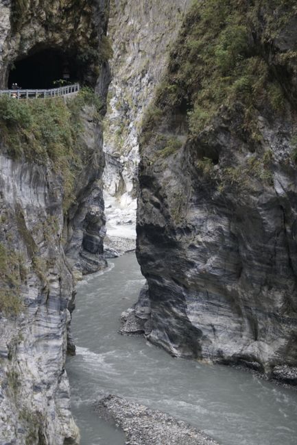
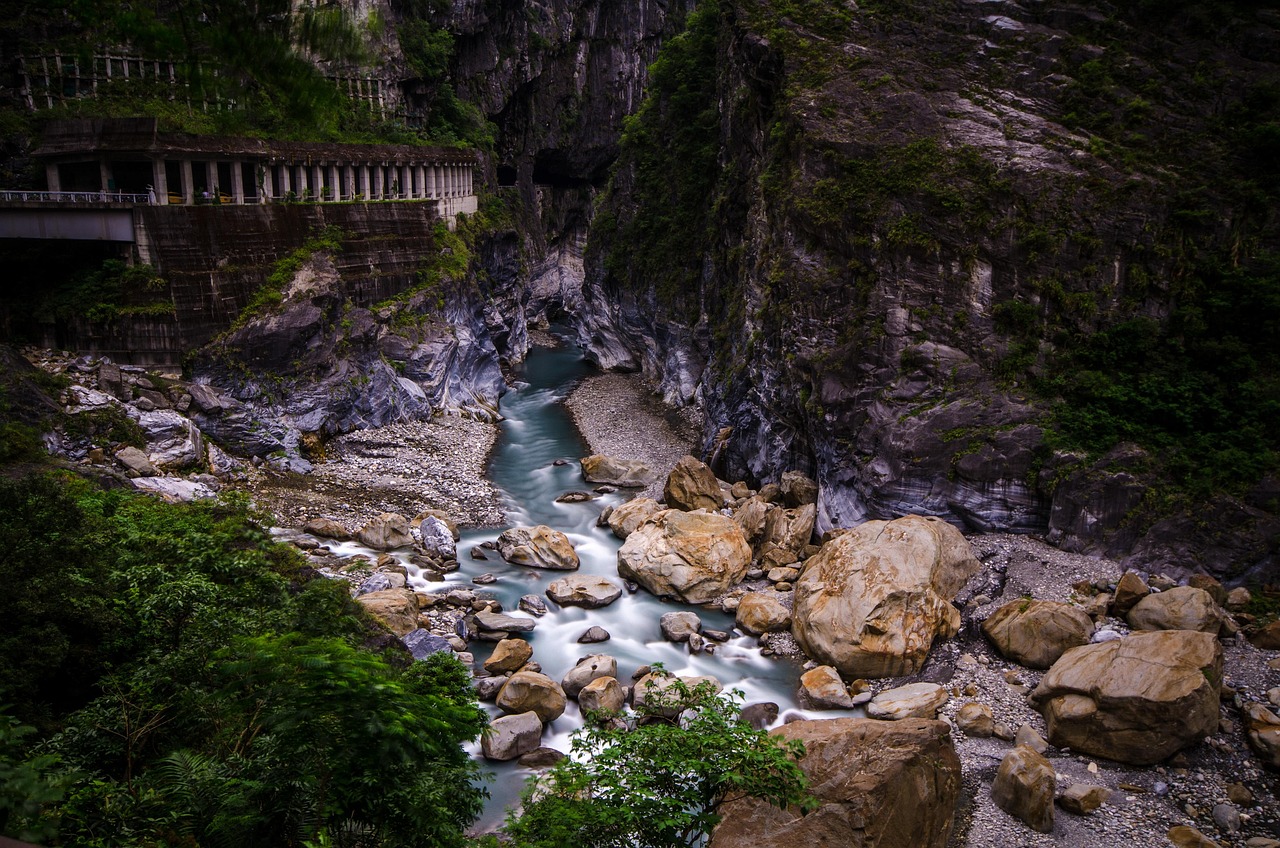
Taroko National Park, on Taiwan’s east coast north of Hualien, protects one of Asia’s most dramatic landscapes: the Liwu River has cut a narrow gorge through marble and schist, with sheer walls rising hundreds of meters above jade-green water, while behind it the land climbs from the Pacific shore to peaks of more than 3,700 m (12,100 ft) in only a few dozen kilometers. Established in 1986, the park covers about 920 km² (355 sq miles) and is home to the Truku people, whose name it bears. On April 3, 2024, a magnitude 7.2 earthquake centered just off Hualien triggered landslides throughout the gorge, closing the park; since then, it has reopened in stages, but in 2026 several of its best-known trails, including Shakadang, Swallow Grotto and Baiyang, remained closed for long-term repairs, and the road through the gorge opened only at set times. A visit is still rewarding, with the visitor center, the Taroko Terrace, Tianxiang and several trails open, plus the Qingshui Cliffs on the coast, but you need to plan around the current rules.
Right now in Taroko National Park (Taroko)
- Wed21–24°C70–75°F2 mm rain
- Thu22–24°C71–75°F3 mm rain
- Fri21–27°C70–80°F1 mm rain
Top tours in Taroko National Park
See all tours for Taroko National Park →
From local operators, with prices and reviews; you check availability and book on Viator, our partner. We may earn a commission at no extra cost to you. How we earn money
Taroko at a glance
- Best for: gorge scenery, marble cliffs, coastal views, Indigenous culture and, where open, short hikes.
- How long: one full day from Hualien; two days to add the coast, Qixingtan and more trails.
- Best time: March to May and October to November; avoid typhoons and heavy rain, which close roads and trails.
- Getting there: Taiwan Railway express trains from Taipei to Hualien or Xincheng (Taroko) station in about 2–2.5 hours, then a bus, taxi or tour.
- Entry: free; some trails need permits.
- Good to know: Provincial Highway 8 through the gorge opens only during set release periods, with a night closure.
- Before you go: visa-free entry, the online arrival card, money and general safety are in our Taiwan travel guide.
Status, closures and rules (as of October 2026)
The 2024 earthquake loosened rock throughout the gorge, and typhoons and heavy rain since then have caused further rockfalls and landslides, so the park reopens areas only when slopes are stabilized. Reopening dates can slip after every storm or aftershock, and areas that are open can close at short notice. Check the Taroko National Park Headquarters’ announcements and the Directorate General of Highways’ road information before you go.
What has reopened
In March 2026, the park’s director listed the areas open since the earthquake as the Taroko Visitor Center, the Taroko Terrace Trail, the Tianxiang Recreation Area, the Dacingshui (Daqingshui) Recreation Area on the coast, the Chongde Trail, the Dali–Datong Trail, and the Liwushan and Cianyanlishan hiking trails. The Lüshui recreation area, west of the Tunnel of Nine Turns, partly reopened in early 2026 with conditions. Higher up, the Hehuanshan area on the western edge of the park reopened earlier, in 2024.
What remains closed
According to the same update, the Buluowan Terrace and the Tunnel of Nine Turns (Jiuqudong) were due to reopen later in 2026; the Changchun (Eternal Spring) Shrine trail was not expected to reopen before 2029; and the Shakadang, Swallow Grotto (Yanzikou) and Baiyang trails were not expected to be repaired until 2031. Four damaged road tunnels were scheduled to be repaired by July 2028. The Zhuilu Old Road, a cliff path high above the gorge that requires a permit, has a separate schedule; check the park’s announcements for its current status.
Highway 8 traffic controls
Provincial Highway 8, the Central Cross-Island Highway, runs through the gorge from the park entrance to Tianxiang and on over the mountains. According to the National Park Service’s notice for June 2026, the Directorate General of Highways allowed traffic between the Taroko entrance and Tianxiang only during five release periods a day: 6:30–8:00 a.m., 10:00–10:05 a.m., noon–1:00 p.m., 3:00–3:05 p.m. and 5:00–6:00 p.m., with the road closed from 6:30 p.m. to 6:30 a.m. Between Guanyuan and Tianxiang, further west, two-way traffic ran from 6:30 a.m. to 4:30 p.m., with a night closure from 6 p.m. Near the entrance, traffic follows a one-way loop through the Shakadang, Xila’an and Changchun tunnels. The schedule is set month by month and can change with the weather or emergency works, so check the latest notice; release periods may be delayed or canceled.
The park’s key rules
- Stay on open trails and roads; closed areas are closed because of rockfall risk.
- Wear a helmet where the park asks you to, and don’t stop under overhanging cliffs.
- Apply in advance for permits where required, such as the Zhuilu Old Road and some high-mountain routes.
- Don’t feed or approach macaques, and don’t collect rocks or plants.
- Drones need permission, and fires are not allowed outside designated areas.
The gorge and its sights
The Taroko Visitor Center and Taroko Terrace
At the eastern end of the gorge, the visitor center has exhibitions on the park’s geology, wildlife and Truku culture, maps and the latest trail news, plus a café. Behind it, the short Taroko Terrace Trail leads to viewpoints over the river where it leaves the mountains.
The Taroko Arch and the park entrance
The traditional Chinese-style gateway at the start of Highway 8 is the classic photo stop, near the Taroko (Xincheng) area with its small shops and a Catholic church built in Indigenous style.
Buluowan
A river terrace above the gorge, once a Truku village site, with a visitor center, a crafts area and the Shanyue suspension bridge across the gorge, scheduled to reopen in stages in 2026.
Tianxiang
At the western end of the main gorge, about 19 km (12 miles) from the entrance, Tianxiang is a small settlement and recreation area with the Xiangde Temple’s white pagoda and Guanyin statue on a hill, a suspension bridge, a hotel and a few places to eat. It is the end point for most day trips and the start of the high road west.
The Qingshui Cliffs
North of the park entrance, on the Suhua Highway (Provincial Highway 9), sheer cliffs drop straight into the deep blue Pacific for about 21 km (13 miles). The viewpoints at Huide and the beach at Dacingshui give the best views; the Suhua Highway has its own traffic controls during construction.
Qixingtan
A crescent of pebble beach just north of Hualien city, with views of the coastal mountains and the sunrise; the sea is too rough for swimming.
Hiking in Taroko
Short trails open in 2026
- Taroko Terrace Trail: an easy walk behind the visitor center.
- Chongde Trail: a short coastal walk near the Qingshui Cliffs, with pebble beaches.
- Dali–Datong Trail: a long, steep climb from the Taroko entrance to the remote Truku villages of Dali and Datong, with tremendous views; allow a full day and check whether you need a permit or a local guide.
- Liwushan and Cianyanlishan trails: forest climbs to viewpoints over the coast and the river mouth.
The Zhuilu Old Road
Before the earthquake, this was Taroko’s most spectacular hike: a path cut into the cliff about 500 m (1,640 ft) above the river, part of an old Japanese-era police road. It needs a park entry permit applied for in advance, with daily quotas; check its current status with the park.
The high mountains
Hehuanshan, on the park’s western edge, is reached by road over the Wuling pass at about 3,275 m (10,745 ft), the highest road pass in Taiwan, with easy trails to 3,000 m (9,800 ft) peaks and winter snow in some years. Climbs to Nanhu Dashan and Qilai need permits, lodge bookings and mountain experience. See our hiking guide.
Other things to do around Taroko
Hualien city
Hualien, 20–30 minutes south of the park entrance, is the main base: a relaxed small city with the Dongdamen Night Market, cultural parks in old buildings, the Pine Garden on a hill above the harbor, seafront cycle paths and excellent marble and stone workshops.
Truku and Amis culture
The Truku people, Taroko’s original inhabitants, are known for weaving, facial tattooing in the past and hunting traditions; Buluowan and village tours introduce their culture. South of Hualien, the Amis are the largest Indigenous group, with summer harvest festivals in July and August.
Food
In Hualien, try the city’s famous wonton soup, mochi, pork buns and Indigenous dishes such as bamboo-tube rice and wild boar sausage at roadside stalls. Inside the park, food choices are limited to Tianxiang and the visitor center, so carry snacks and water.
Getting there
By train
Taiwan Railway express trains (Tze-Chiang, Puyuma and Taroko) run from Taipei, via Yilan, to Hualien in about 2–2.5 hours; some stop at Xincheng (Taroko) station, the closest to the park entrance. Seats sell out on weekends and holidays, so book as soon as booking opens, usually 28 days ahead. Trains continue south to Taitung and round to Kaohsiung.
By road
From Taipei, the Suhua Highway (Provincial Highway 9) and the Suhua Improvement tunnels link Yilan with Hualien; both have construction controls. Coming from the west, Highway 8 crosses the mountains from Taichung via Lishan and Dayuling, but in 2026 the eastern section opened only at set times; drivers making the whole crossing had to arrive at Tianxiang by 5 p.m. eastbound, or pass the Shakadang Tunnel checkpoint by 3 p.m. westbound, according to the National Park Service.
By air
Hualien Airport has domestic flights from Taipei Songshan, Taichung and Kaohsiung, and some regional flights.
Getting around: practical details
Buses run from Hualien and Xincheng into the park, with fewer services during closures; many visitors hire a taxi or private driver for the day, which lets you work around the Highway 8 release periods, or join a tour from Hualien. Scooter rental is common in Hualien, but only for experienced, licensed riders; the gorge road is narrow and busy with trucks and buses.
Around Taroko
- Hualien city and Qixingtan: night markets, seafront paths and a pebble beach.
- The East Coast National Scenic Area: south of Hualien, Provincial Highway 11 follows the coast past the Shitiping rocks and the Tropic of Cancer marker to Taitung.
- The East Rift Valley: rice fields, hot springs at Ruisui and cycling routes between the mountain ranges.
- Yilan: the hot springs of Jiaoxi and the surf beach of Wai’ao on the way back to Taipei. See our Taipei guide.
Nearby destinations
- Sun Moon Lake54 km
- Alishan90 km
- Taipei100 km
- Tainan176 km
- Kaohsiung202 km
- Kenting National Park249 km
- Ishigaki Island291 km
When to go and how long to stay
Hualien has a humid subtropical climate, wetter in winter than the west coast because of the northeast monsoon, and with its heaviest rain in the fall, when typhoons and the monsoon combine. Rockfall risk in the gorge rises after heavy rain. The table shows the Central Weather Administration’s 1991–2020 normals for its Hualien station, on the coast about 20 km (12 miles) south of the park entrance; the gorge is a little cooler, and the mountains much colder. Rain days count days with at least 0.1 mm of rain.
| Month | Average high / low | Rain (rain days) | What to expect |
|---|---|---|---|
| January | 21 °C (71 °F) / 16 °C (60 °F) | 58 mm (2.3 in), 13 days | Cool, cloudy; frequent drizzle |
| February | 22 °C (71 °F) / 16 °C (61 °F) | 75 mm (2.9 in), 14 days | Lunar New Year crowds |
| March | 24 °C (74 °F) / 18 °C (64 °F) | 77 mm (3.0 in), 14 days | Mild; good for hiking |
| April | 26 °C (79 °F) / 20 °C (68 °F) | 77 mm (3.0 in), 14 days | Pleasant; spring greenery |
| May | 29 °C (84 °F) / 22 °C (72 °F) | 187 mm (7.4 in), 16 days | Plum rains; check closures |
| June | 31 °C (88 °F) / 25 °C (76 °F) | 166 mm (6.5 in), 12 days | Hot; afternoon storms |
| July | 32 °C (90 °F) / 26 °C (78 °F) | 198 mm (7.8 in), 8 days | Hot; typhoon season begins; Amis harvest festivals |
| August | 32 °C (90 °F) / 25 °C (78 °F) | 259 mm (10.2 in), 10 days | Typhoon risk |
| September | 31 °C (87 °F) / 24 °C (76 °F) | 330 mm (13.0 in), 13 days | Typhoons and heavy rain |
| October | 28 °C (83 °F) / 22 °C (72 °F) | 351 mm (13.8 in), 12 days | Wettest month as the monsoon starts |
| November | 26 °C (78 °F) / 20 °C (68 °F) | 175 mm (6.9 in), 12 days | Cooler; rain easing |
| December | 23 °C (73 °F) / 17 °C (63 °F) | 84 mm (3.3 in), 11 days | Mild; quiet season |
The figures add up to about 2,030 mm (80 in) of rain a year. March to May, and the drier spells of November, are usually the best times; in summer, start early to beat the heat and afternoon storms.
One day at Taroko
Take an early train to Hualien or Xincheng and a taxi into the park in the first release period. Visit the visitor center and Taroko Terrace, drive to Tianxiang (and Buluowan if it has reopened), then return in an afternoon release period to see the Qingshui Cliffs from Dacingshui or Chongde before sunset.
Two or three days
Stay in Hualien and add a day on the Dali–Datong or Liwushan trails, a morning at Qixingtan and the Hualien night markets, or a drive south along the East Coast. With a car and good weather, cross Highway 8 to Hehuanshan, staying a night in the mountains.
Where to stay
- Hualien city: the widest choice, from hostels to international hotels, with restaurants and night markets.
- Xincheng and the park entrance: guesthouses and B&Bs close to the gorge and Xincheng station.
- Tianxiang: a hotel and a youth activity center inside the gorge, subject to the road’s opening times.
- Qixingtan: seaside B&Bs a short drive from the park.
Food and drink on the trail
Carry water, snacks and lunch for trails; there are few places to buy food inside the gorge except at Tianxiang and the visitor center. Convenience stores in Xincheng and Hualien sell rice balls, drinks and sandwiches for the day.
What a trip to Taroko costs
Prices are approximate, for October 2026, converted at about NT$31.8 to the US dollar.
| Item | Typical cost |
|---|---|
| Park entry | free |
| Taiwan Railway express, Taipei to Hualien, one way | about NT$340–450 (about US$11–14) |
| Bus from Hualien to the park, one way | about NT$100–200 (about US$3.10–6.30) |
| Taxi or private driver for the day | NT$3,000–4,500 (about US$94–140) |
| Scooter rental in Hualien, per day | NT$400–700 (about US$13–22) |
| Hualien wonton soup | NT$80–150 (about US$2.50–4.70) |
| Lunch at Tianxiang | NT$150–350 (about US$4.70–11) |
| Hostel bed in Hualien, per night | NT$500–900 (about US$16–28) |
| Mid-range hotel double in Hualien, per night | NT$2,500–4,500 (about US$79–140) |
| Hotel in Tianxiang, per night | NT$4,000 and up (about US$125 and up) |
Practical tips for Taroko
- Check before you go: the park’s announcements for trail openings and the monthly Highway 8 traffic controls.
- Plan around release periods: arrive at the checkpoints before each window opens, and allow for delays.
- Book trains early: east-coast express trains sell out on weekends.
- Go early: mornings are clearer, cooler and less busy.
- Cash: carry cash for buses, food stalls and small shops.
Safety
Rockfalls and landslides are the main hazard at Taroko, especially after earthquakes, typhoons and heavy rain; obey closures, wear a helmet where required, keep moving under cliffs and don’t stop in marked danger zones. Earthquakes: Hualien is one of Taiwan’s most seismically active areas; if you feel a strong tremor in the gorge, move away from cliffs and slopes if you can safely do so, and follow park staff. Typhoons: from about July to October, follow the Central Weather Administration’s warnings; the park and roads close during storms and may stay closed afterward. Roads: Highway 8 and the Suhua Highway are narrow and winding, with tunnels and heavy vehicles; drive slowly and never stop in tunnels. Rivers and the sea: don’t swim in the Liwu River or at Qixingtan, where currents are dangerous. Wildlife: macaques can grab food, and venomous snakes live in the forest; stay on trails. In an emergency, call 110 for the police or 119 for fire and ambulance.
What to pack for Taroko
Sturdy walking shoes, a rain jacket or umbrella, a hat and sunscreen, water and snacks, insect repellent, a light fleece for the mountains, a headlamp for longer hikes, your passport for permits, and a power bank for your phone. Taiwan uses 110 V and flat two-pin plugs.
Taroko travel FAQ
Is Taroko Gorge open in 2026?
Partly. The visitor center, the Taroko Terrace, Tianxiang, Dacingshui and several trails have reopened, and Highway 8 runs through the gorge at set times, but Shakadang, Swallow Grotto and Baiyang remained closed, with repairs expected to last until about 2031.
When will Shakadang and Swallow Grotto reopen?
According to park officials in March 2026, these trails and Baiyang were not expected to be repaired until 2031, and the Changchun Shrine not before 2029. Check the park’s announcements for updates.
Can I drive through Taroko Gorge?
Yes, during the set release periods. In June 2026, traffic between the park entrance and Tianxiang was allowed five times a day, with the road closed from 6:30 p.m. to 6:30 a.m.; the schedule is updated monthly.
How do I get from Taipei to Taroko?
Take a Taiwan Railway express train to Hualien or Xincheng in about 2–2.5 hours, then a bus, taxi or tour into the park.
Is there an entrance fee for Taroko National Park?
No, entry is free. Some trails, such as the Zhuilu Old Road and high-mountain routes, need permits applied for in advance.
How many days do I need for Taroko?
One full day from Hualien covers the open sights; two or three days let you add longer hikes, the coast and Hualien city.
What happened to Taroko in the 2024 earthquake?
The magnitude 7.2 earthquake of April 3, 2024 caused landslides and rockfalls throughout the gorge, damaging roads, tunnels and trails. The park has reopened in stages since late 2024.
When is the best time to visit Taroko?
March to May and October to November, avoiding the typhoon season and heavy rain, when roads and trails close.
Is the Zhuilu Old Road open?
Its status depends on repairs and safety checks; it requires a permit and has daily quotas. Check the Taroko National Park Headquarters’ announcements before you plan it.
Is it safe to visit Taroko after the earthquake?
Yes, if you stay within open areas, follow closures and helmet rules, and avoid visiting during or right after heavy rain, typhoons or strong aftershocks.
Plan your trip
Partner links: TravelerCenter may earn a commission if you book, at no extra cost to you.
🇨🇳 Useful Mandarin Chinese phrases for Taroko National Park
All 38 Mandarin Chinese phrases: restaurant, hotel, emergencies, romance (printable) →
Sources · last reviewed 4 October 2026
Researched and last reviewed on 4 October 2026. Highway 8 traffic controls: the National Park Service (notice for June 2026, from the Directorate General of Highways); climate normals (1991–2020): the Central Weather Administration; visa-free entry and the arrival card: the Bureau of Consular Affairs and the National Immigration Agency; exchange rate: the Central Bank. The list of reopened and closed areas and the repair timetable come from Taroko National Park Headquarters and highway officials as reported by the Taipei Times in March 2026, because the park’s own website could not be read here; they are flagged for checking. Park area, distances, train times, the Zhuilu Old Road rules, bus routes and typical prices are general references or estimates. Rules change, so check the official announcements before you go. For entry rules, money and general safety, see our Taiwan travel guide.
Data: Weather: MET Norway (CC BY 4.0) · Sea temperature: NOAA CoastWatch · Air quality: OpenAQ · Rates: ECB · Wikidata (CC0)