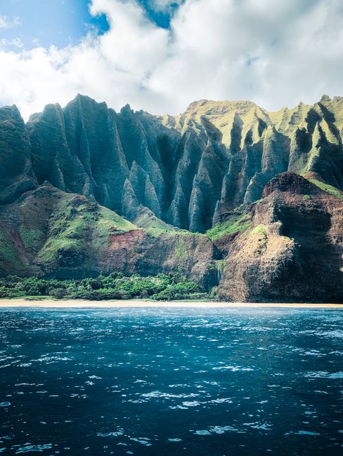
Kauaʻi, the oldest and northernmost of Hawaiʻi’s main islands, is the “Garden Isle”: steep green mountains, red-earth canyons and long beaches, with no building taller than a palm tree. The sheer cliffs and hanging valleys of the Nā Pali Coast can be reached only on foot, by boat or seen from the air; Waimea Canyon cuts a gorge of red and green rock through the west side; Hanalei Bay curves beneath waterfall-streaked peaks on the north shore; and sunny Poʻipū on the south shore has the island’s easiest swimming beaches. Kauaʻi took the brunt of Hurricane Lowell in early September 2026, and as of 2 October 2026 most of its state parks, including Hāʻena, the Nā Pali Coast, Waimea Canyon and Kōkeʻe, were still closed for repairs. The beaches, towns and resorts are open, but check the latest park and road news before you build a trip around a hike.
Right now in Kauai (Līhuʻe)
- Tue21–26°C71–79°F5 mm rain
- Wed19–26°C67–80°F9 mm rain
- Thu21–28°C70–83°F2 mm rain
- Mon 12 Oct Columbus Day
- Mon 12 Oct Indigenous Peoples' Day · regional holiday in Hawaii
Top tours in Kauai
See all tours for Kauai →
From local operators, with prices and reviews; you check availability and book on Viator, our partner. We may earn a commission at no extra cost to you. How we earn money
Kauaʻi at a glance
- Best months: April to June and September to October for drier weather and calmer seas; winter brings big north-shore surf, more rain and whales offshore.
- Time needed: 4–5 days for Poʻipū, Waimea Canyon, a Nā Pali boat trip and Hanalei; a week to add the Kalalau Trail’s first miles and Kōkeʻe’s rainforest when they reopen.
- Getting there: Līhuʻe Airport (LIH) on the east coast, with nonstop flights from several West Coast cities and short inter-island flights from Honolulu.
- Costs (as of October 2026): Hāʻena State Park shuttle $45 per adult round trip, or $20 per car per time slot plus $5 per person; Waimea Canyon and Kōkeʻe $5 per person plus $10 parking for non-residents; hotel bills add about 18.7% in taxes.
- Before you go: entry rules (ESTA or visa), money, driving and general safety are in our United States travel guide.
Hurricane Lowell: what is open in October 2026
Hurricane Lowell hit Kauaʻi in early September 2026, bringing down trees and power lines, scouring bridges and blocking roads, and Hurricane Nolo passed south of the islands later that month. The state and county have been reopening areas step by step. According to the Hawaiʻi Department of Land and Natural Resources (DLNR), as of 2 October 2026:
- Most Kauaʻi state parks remain closed, including Hāʻena State Park, the Nā Pali Coast State Wilderness Park (Kalalau Trail), Waimea Canyon, Kōkeʻe and Polihale. All state park camping on Kauaʻi is closed.
- Wailua River State Park has partly reopened: the river and its designated landing and trailhead are open, but individual kayakers may not go to the Fern Grotto, and the hike to Uluwehi (Secret) Falls is closed.
- Kōkeʻe Road (Route 550) remains closed until further notice.
- Hāʻena’s shuttle has been suspended since 9 September, and cancelled shuttle and park reservations are refunded automatically.
- State forest lands and trails on Kauaʻi are closed except a few areas, such as Keāhua Arboretum.
Kūhiō Highway is open to the end of the road at Hāʻena, according to the Hawaiʻi Department of Transportation, though repairs to scoured bridges at Wainiha have brought weight limits and short closures, and lane closures continue on the east side. The launch ramp at Port Allen, where most Nā Pali boat tours start, reopened on 2 October 2026. County beach parks, hotels, restaurants and shops are operating. Because reopening dates change week by week, check the DLNR park notices page, gohaena.com and HDOT’s Kauaʻi updates before you go, and be ready with a beach day as a backup.
Hāʻena State Park, Kēʻē Beach and the Kalalau Trail
At the end of the road on the north shore, Hāʻena State Park holds Kēʻē Beach, restored taro terraces (loʻi kalo) and the trailhead of the Kalalau Trail, which runs 11 miles (18 km) along the Nā Pali Coast. Since the park reopened in 2019 after the 2018 floods, visits have been capped and every non-resident needs a reservation. These are the rules when the park is open (it was closed as of October 2026, as above):
- Shuttle (recommended): the North Shore shuttle from the Waipā Park and Ride in Hanalei or from Princeville includes park entry. As of October 2026 a round trip costs $45 for ages 16 and over (raised from $40 on 15 June 2026), $25 for ages 4–15, and children 3 and under ride free on a lap. Shuttle ticket holders must ride the shuttle.
- Parking and entry: $20 per car per time slot plus $5 per person: morning 6:30 a.m.–12:30 p.m., afternoon 12:30–5:30 p.m. or evening 4:30 p.m. to sunset. Everyone named must arrive together in one vehicle; buy several slots to stay longer. These sell out within minutes of release.
- Entry only: $5 per person, for guests of Hawaiʻi residents and people dropped off, walking or cycling.
- When to book: reservations open 30 days ahead at midnight Hawaiʻi time on gohaena.com; check again between 7 and 8 a.m. for cancellations. National park passes and other discounts are not accepted, adult IDs are checked, and reservations cannot be transferred.
- Changes: cancel at least 48 hours ahead for a refund minus a 10% fee; later cancellations are non-refundable, but everything is refunded if the shuttle is suspended.
- Do not park outside the park: nearby roadside parking is restricted, tickets cost $200 or more and cars are towed.
When the park is open, it is open daily from 7 a.m. to 6:45 p.m. (the lot opens at 6 a.m.), and Hawaiʻi residents with a state ID enter and park free. A Hāʻena reservation lets you hike the first 2 miles (3 km) of the Kalalau Trail to Hanakāpīʻai Beach, and on to Hanakāpīʻai Falls, an 8-mile (13 km) round trip from the trailhead with stream crossings. Going any farther than Hanakāpīʻai Valley, even for a day hike, needs a Nā Pali Coast camping permit from the Division of State Parks, issued up to 90 days ahead and often sold out months in advance; camping is allowed only at Hanakoa and Kalalau. Do not swim at Hanakāpīʻai Beach, where currents are deadly, and never cross the stream when it is rising after rain.
Waimea Canyon and Kōkeʻe State Parks
Waimea Canyon, about 10 miles (16 km) long and some 3,000 feet (900 m) deep, is a gorge of red, orange and green rock carved into the west side of the island. Waimea Canyon Drive and Kōkeʻe Road climb from the town of Waimea along its rim to Kōkeʻe State Park at about 4,000 feet (1,200 m), where lookouts gaze down into the Kalalau Valley and the Nā Pali Coast, and trails lead through native forest to the Alakaʻi Swamp. As of October 2026, both parks charge non-residents $5 per person and $10 per vehicle, with one parking ticket valid at lots in both parks; Hawaiʻi residents enter free. They are open during daylight hours.
Closures to know about: Kōkeʻe Road and both parks were closed after Hurricane Lowell, as of 2 October 2026. Even before the storm, the main Waimea Canyon Lookout had been closed since 14 July 2025 for safety improvements, and Kōkeʻe’s campground is closed for upgrades from May 2026 to spring 2027. The Puʻu o Kila lookout at the end of the road reopened in January 2026. The upper road is often in cloud by late morning, so go early for the clearest views.
Top things to see on Kauaʻi
Prices, hours and reservation rules below were checked on the official sites in October 2026; check again before you go.
The Nā Pali Coast from the sea or the air
When the trail is closed, the best way to see the Nā Pali Coast is by boat. Catamaran, raft and snorkel tours leave from Port Allen on the south-west coast, and summer seas allow trips along the whole coast and into sea caves; in winter, high surf limits routes. Helicopter tours from Līhuʻe fly over the Nā Pali cliffs, Waimea Canyon and the rain-soaked summit of Waiʻaleʻale. Choose operators with clear safety records and ask about weather cancellations.
Hanalei Bay and the north shore
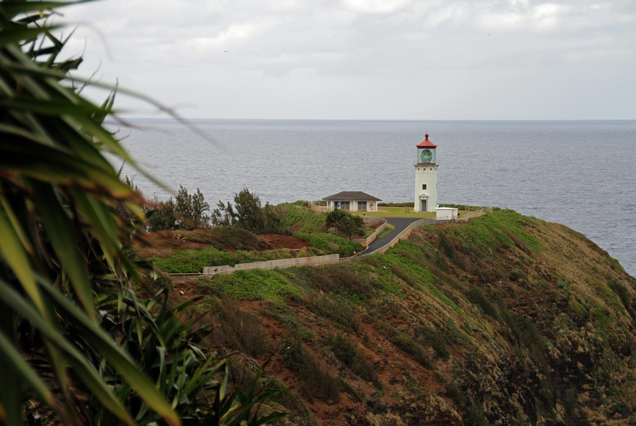
A wide crescent of sand backed by mountains that turn into a hundred waterfalls after rain, with a pier, gentle summer swimming and big winter surf. The one-lane bridges into Hanalei and the taro fields of the Hanalei National Wildlife Refuge set the slow pace of the north shore; Kīlauea Point, with its lighthouse and seabird colony, is a short drive east.
Poʻipū
The sunny south shore resort area has the safest family swimming on the island at Poʻipū Beach Park, where Hawaiian monk seals often rest on the sand (stay well back), plus Spouting Horn, a blowhole in the lava shelf, and the Māhāʻulepū coast walk.
Wailua River and the east side
Hawaiʻi’s only navigable river winds past sacred sites to the Fern Grotto. As of October 2026 the river and landing were open again, but individual kayakers could not go to the Fern Grotto and the trail to Uluwehi (Secret) Falls was closed. Nearby, ʻŌpaekaʻa Falls is visible from a roadside lookout, and the coastal path in Kapaʻa is good for walking and cycling.
Old towns: Waimea, Hanapēpē and Kōloa
Waimea, where Captain Cook first landed in Hawaiʻi in 1778, is the gateway to the canyon. Hanapēpē has a swinging footbridge and galleries, with an art night on Fridays, and Kōloa was the site of Hawaiʻi’s first commercial sugar mill.
Nature
- Hanalei Bay
- Kalalau Trail
- Wailua Falls
Protected areas
- Nā Pali Coast State Park
- Wailua River State Park
- Waimea Canyon State Park
Monuments
- Daniel K. Inouye Kīlauea Point Lighthouse
Parks and gardens
- Poipu Beach Park
Ocean safety and wildlife
Kauaʻi’s beaches are beautiful and often dangerous, with strong currents, shorebreak and few lifeguards on the north and west shores. Swim only at lifeguarded beaches when you can, ask the lifeguards about conditions, and stay out of the water at Hanakāpīʻai and during high surf. In winter, north swells make the Hanalei and Hāʻena shores unsafe for swimming; in summer, the south shore gets more waves. Hawaiian monk seals and green sea turtles haul out on Kauaʻi’s beaches; NOAA asks visitors to stay at least 50 feet (15 m) from seals and 10 feet (3 m) from turtles. Use mineral sunscreen: Hawaiʻi bans the sale of sunscreens with oxybenzone and octinoxate. See our beaches and snorkeling guides.
Other things to do on Kauaʻi
- Hiking: when they reopen, the Kalalau Trail to Hanakāpīʻai, the Awaʻawapuhi and Pihea trails in Kōkeʻe and the Sleeping Giant (Nounou) trail near Kapaʻa. Trails are steep and slippery when wet. See our hiking guide.
- Boat trips: Nā Pali Coast cruises from Port Allen, and whale watching in winter. See our boat trips guide.
- Snorkeling and diving: Poʻipū Beach and Lāwaʻi Beach on the south shore, Kēʻē and Tunnels on the north shore in calm summer seas, and boat dives to the island of Niʻihau’s offshore reefs in summer. See our diving guide.
- Surfing: lessons in Hanalei Bay and Poʻipū. See our surfing guide.
- Kayaking: the Wailua and Hanalei rivers, with permitted outfitters.
Getting there and getting around
Līhuʻe Airport (LIH) is a few minutes from Līhuʻe town, with nonstop flights from several West Coast cities and frequent flights from Honolulu, about 35 minutes away. One main road, the Kūhiō Highway (Route 56) to the north and the Kaumualiʻi Highway (Route 50) to the west, circles about three-quarters of the island; the Nā Pali Coast blocks the rest, so you cannot drive all the way around. A rental car is the easiest way to explore; the county’s Kauaʻi Bus serves the main towns, but not Waimea Canyon or Hāʻena.
| From Līhuʻe Airport (LIH) to | Distance | Driving time |
|---|---|---|
| Kapaʻa (east side) | about 8 miles (13 km) | 20–30 minutes in traffic |
| Poʻipū (south shore) | about 15 miles (24 km) | 25–35 minutes |
| Princeville and Hanalei | about 30–33 miles (48–53 km) | 50–70 minutes |
| Hāʻena State Park | about 40 miles (64 km) | 1.25–1.5 hours |
| Waimea town | about 25 miles (40 km) | 40 minutes |
| Kōkeʻe (end of road) | about 45 miles (72 km) | 1.5 hours (road closed as of October 2026) |
Traffic is heavy through Kapaʻa at rush hour, when a contraflow lane often operates on the Kūhiō Highway. On the north shore, the one-lane bridges have their own etiquette: let a group of five to seven cars cross, then yield.
Around Kauaʻi and other islands
- Polihale: a remote, wild beach at the end of the west side’s dirt road, closed as of October 2026.
- Kīlauea Point: lighthouse and seabird refuge on the north shore.
- Niʻihau: the privately owned “Forbidden Island”, visible from the west side; only limited tours go there.
- Oʻahu: Waikīkī, Diamond Head and Pearl Harbor, a short flight away (see our Honolulu guide), with Maui and Hawaiʻi Island beyond (see our Maui, Hawaii Island and Hawaii Volcanoes National Park guides).
Nearby destinations
- Honolulu190 km
When to go and how long to stay
Kauaʻi is greener and wetter than the other islands. Mount Waiʻaleʻale, in the center, is one of the rainiest places on Earth, while the south and west coasts are much drier. The table uses NOAA’s 1991–2020 climate normals for Līhuʻe Airport on the east coast: average daily highs and lows, and days with at least 0.10 in (2.5 mm) of rain.
| Season | Average high / low | Rainy days per month | What it’s like | Good for |
|---|---|---|---|---|
| Winter (Dec–Feb) | 78–79 °F (26 °C) / 66–69 °F (19–21 °C) | 4–7 | Mild and wetter, with big north swells and flooding rains at times | Whale watching, surf watching |
| Spring (Mar–May) | 79–82 °F (26–28 °C) / 67–71 °F (19–22 °C) | 4–6 | March is wet; drier and calmer by May | Hiking, Nā Pali boat trips |
| Summer (Jun–Aug) | 83–85 °F (28–29 °C) / 73–75 °F (23–24 °C) | 5 | Warm, trade-wind showers, calm north shore | North-shore snorkeling, Nā Pali by sea |
| Fall (Sep–Nov) | 85 °F falling to 81 °F (29 to 27 °C) / 75 °F falling to 71 °F (24 to 22 °C) | 5–7 | Warm, with rain returning in November; hurricane season ends 30 November | Quieter beaches, lower prices |
Līhuʻe averages about 36.2 in (920 mm) of rain a year on about 66 days, more than twice Honolulu’s. Short, light trade-wind showers are common; heavy winter storms can close roads and the Hanalei bridge. The Central Pacific hurricane season runs from 1 June to 30 November. In March 2026 a Kona low storm brought flooding rain to the islands, and in September 2026 Hurricane Lowell caused the closures described above.
Weather month by month
Kauaʻi in 4 days
Day one, settle in at Poʻipū and walk to Spouting Horn at sunset. Day two, a morning Nā Pali Coast boat trip from Port Allen, then Hanapēpē. Day three, the north shore: Kīlauea Point, Hanalei Bay and, if Hāʻena has reopened, the walk to Hanakāpīʻai Beach with a reservation. Day four, Waimea Canyon and Kōkeʻe early in the morning if Kōkeʻe Road is open, or the Wailua River and the east side if not.
A week on Kauaʻi
Split your stay between Poʻipū and Princeville or Hanalei. Add a helicopter flight, a longer Kōkeʻe hike such as Pihea or Awaʻawapuhi, a kayak on the Wailua River, and slow beach days on the north shore in summer or the south shore in winter.
Where to stay on Kauaʻi and the hotel taxes
- Poʻipū: resorts and condos on the sunny south shore, best for families and winter visits.
- Princeville and Hanalei: resorts and rentals on the lush north shore, best in summer; closest to Hāʻena.
- Kapaʻa and Wailua (the Coconut Coast): mid-range hotels and condos in the middle of the island, convenient for both ends.
- Waimea and the west side: a few cottages and inns, closest to the canyon.
Hotel taxes: room rates in Hawaiʻi are quoted before tax. Since 1 January 2026, under Act 96 of 2025, the state transient accommodations tax (TAT) is 11%, up from 10.25%. The County of Kauaʻi adds its own 3% transient accommodations tax, and hotels usually pass on the general excise tax at up to 4.712%. Together that is about 18.7% on top of the room rate. The same 2025 law tried to tax cruise fares, but a federal appeals court blocked that part and the state is not enforcing it until further notice. Many resorts add a daily resort fee and parking charge; under the Federal Trade Commission’s fees rule in force since May 2025, mandatory fees must be included in the advertised total price. Book licensed accommodation only.
Practical tips for Kauaʻi
- Check closures first: in October 2026, look at the DLNR park notices page and gohaena.com before booking any park or hike.
- Book Hāʻena exactly 30 days ahead: at midnight Hawaiʻi time, when slots open; parking sells out in minutes.
- Time zone: Hawaiʻi Standard Time (UTC−10), no daylight saving time; after 1 November 2026, Kauaʻi is 2 hours behind California.
- Flash floods: never cross a rising stream; water can rise within minutes from rain you cannot see.
- Leave nothing in the car at trailheads and beaches.
- Emergencies: call 911. Phone signal is poor on the Nā Pali Coast and in parts of Kōkeʻe.
What to pack for Kauaʻi
Pack light summer clothes and swimwear, a good rain jacket, quick-dry layers, and shoes with real grip for red-mud trails, plus a warm layer for Kōkeʻe, which is much cooler than the coast. Add mineral sunscreen, a rash guard, a dry bag for boat trips, insect repellent, a headlamp and a reusable water bottle, and seasickness tablets for Nā Pali cruises.
Kauaʻi travel FAQ
Is Hāʻena State Park open?
Not as of 2 October 2026: it closed after Hurricane Lowell, and the shuttle was suspended on 9 September. Check gohaena.com and the DLNR park notices for the reopening date.
How do I get a Hāʻena State Park reservation?
On gohaena.com, 30 days ahead at midnight Hawaiʻi time. As of October 2026 the shuttle costs $45 per adult round trip, or $20 per car per time slot plus $5 per person to park.
Do I need a permit to hike the Kalalau Trail?
A Hāʻena reservation covers the first 2 miles to Hanakāpīʻai Beach and the trail to Hanakāpīʻai Falls. Going any farther, even for the day, needs a Nā Pali Coast camping permit from the Division of State Parks, issued up to 90 days ahead.
Is Waimea Canyon open?
As of 2 October 2026, Kōkeʻe Road and the Waimea Canyon and Kōkeʻe state parks were closed after Hurricane Lowell. When open, non-residents pay $5 per person and $10 per vehicle.
How can I see the Nā Pali Coast?
By boat from Port Allen, whose launch ramp reopened on 2 October 2026, by helicopter from Līhuʻe, or on foot from Hāʻena when the park reopens.
Can you drive around Kauaʻi?
No. The road ends at Hāʻena in the north and past Polihale in the west, with the Nā Pali Coast between them, so plan out-and-back trips.
Where is the best place to stay on Kauaʻi?
Poʻipū for sunshine and safe swimming, especially in winter; Princeville or Hanalei for the north shore in summer; Kapaʻa for a central, more affordable base.
What is the hotel tax on Kauaʻi?
About 18.7% as of October 2026: the 11% state transient accommodations tax, Kauaʻi County’s 3% and up to 4.712% general excise tax. Resort fees come on top.
When is the best time to visit Kauaʻi?
April to June and September to October for drier weather and calmer seas. Winter is wetter, with big north-shore surf and whales offshore.
Plan your trip
Partner links: TravelerCenter may earn a commission if you book, at no extra cost to you.
Sources · last reviewed 4 October 2026
Researched and last reviewed on 4 October 2026. Park closures, Hāʻena, Nā Pali Coast, Waimea Canyon and Kōkeʻe fees and rules: Hawaiʻi Department of Land and Natural Resources, Division of State Parks; Hāʻena reservations, shuttle prices and time slots: the official Hāʻena State Park reservation system (gohaena.com); road and bridge repairs: Hawaiʻi Department of Transportation; storm names and dates: Hawaiʻi Department of Taxation and DLNR; hotel taxes: Hawaiʻi Department of Taxation and the County of Kauaʻi; resort fees: Federal Trade Commission; climate: NOAA’s 1991–2020 normals for Līhuʻe Airport. Canyon dimensions, driving times and distances, beach and wildlife descriptions are general knowledge, flagged for checking, and the Hāʻena parking price on gohaena.com differs from an older DLNR page. Closures change week by week in October 2026, so check the official sites before you go. For entry rules, money and general safety, see our United States travel guide.
Also: NOAA NCEI normals 1991–2020, Līhuʻe Airport (climate)
Data: Weather: MET Norway (CC BY 4.0) · Sea temperature: NOAA CoastWatch · Rates: ECB · Holidays: Nager.Date · Costs: World Bank ICP and price levels · © OpenStreetMap contributors (ODBL) · Wikidata (CC0)