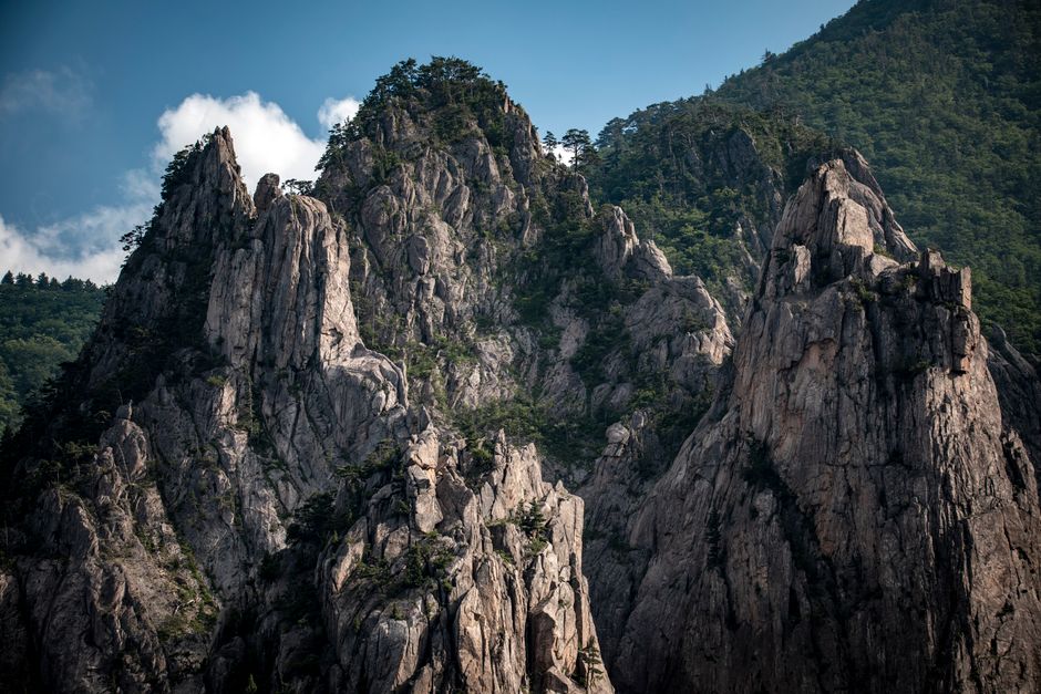
Seoraksan National Park, in the northeast of South Korea, is the country’s most spectacular mountain range: jagged granite ridges and pinnacles, deep valleys of clear pools and waterfalls, ancient temples and, in October, the finest fall colors in Korea. The park covers about 398 km² (154 sq miles) of the Taebaek Mountains just inland from the East Sea, with Daecheongbong, at 1,708 m (5,604 ft) the third-highest peak in South Korea, at its heart. Most visitors start at Seorak-dong near the coastal city of Sokcho, for the Sinheungsa temple, the cable car to Gwongeumseong, the climb to Ulsanbawi rock and the valley walk to Biseondae; serious hikers tackle the long trails to Daecheongbong from Osaek or Hangyeryeong, often overnight in a mountain shelter. Seoraksan is busy: plan around the Korea National Park Service’s trail entry times, the spring and fall fire-season closures and the reservations needed for some trails and all shelters.
Right now in Seoraksan National Park (Seorak-dong)
- Wed8–19°C46–65°FClear
- Thu8–21°C46–70°FClear
- Fri11–21°C51–70°FClear
- Fri 9 Oct Hangul Day (한글날)
Top tours in Seoraksan National Park
See all tours for Seoraksan National Park →
From local operators, with prices and reviews; you check availability and book on Viator, our partner. We may earn a commission at no extra cost to you. How we earn money
Seoraksan at a glance
- Best for: mountain hiking, granite peaks and ridges, waterfalls and valleys, Buddhist temples, fall colors and the East Sea coast nearby.
- How long: 1 day for Seorak-dong’s highlights; 2 days for Daecheongbong with a night in Sokcho or a mountain shelter.
- Best time: late September to early November for the colors (peak around late October), and May to June for green valleys; winter is snowy.
- Getting there: about 2.5 hours by express bus from Seoul to Sokcho, then a local bus to Seorak-dong; or the KTX to Gangneung and a bus north.
- Fees: no park entry fee; the Seorak cable car costs 16,000 won (about US$11.70) round trip.
- Rules to know: trail entry cut-off times, seasonal closures for fire prevention, reservations for shelters and some trails, and no cooking, fires or alcohol.
- Before you go: the K-ETA (and the exemption for 22 countries until December 31, 2026), money and general safety are in our South Korea travel guide; see also our Gangneung guide.
Fees, reservations and rules (as of October 2026)
According to the Korea National Park Service (KNPS), which manages the park, there is no entry fee for Seoraksan; Korea abolished the separate cultural heritage admission charged at temples such as Sinheungsa on May 4, 2023. You pay for parking, the cable car, shelters and campsites.
Trail entry times
To keep hikers off the mountain after dark, the KNPS sets an entry time window for every trail: you may start between the opening and cut-off times, and rangers turn people back after the cut-off. According to the KNPS, the main windows are:
| Trail start | April–October | November–March |
|---|---|---|
| Osaek (Namseorak) to Daecheongbong | 3 a.m. to noon | 4 a.m. to 11 a.m. |
| Hangyeryeong to the Hangyeryeong junction | 3 a.m. to noon | 4 a.m. to 10 a.m. |
| Biseondae toward Yangpok and Huiungak | 3 a.m. to 2 p.m. | 4 a.m. to noon |
| Biseondae toward Madeungnyeong | 3 a.m. to 11 a.m. | 4 a.m. to 10 a.m. |
| Biseondae to Geumganggul cave | 3 a.m. to 2 p.m. | 4 a.m. to 2 p.m. |
| Baekdam toward Suryeomdong, Socheong or Oseam | 3 a.m. to 2 p.m. | 4 a.m. to 1 p.m. |
| Hangyesanseong to Daeseung Falls | 3 a.m. to 4 p.m. | 4 a.m. to 4 p.m. |
| Heullimgol to Yongso Falls | 3 a.m. to 2 p.m. | 4 a.m. to 2 p.m. |
The short trails from Sogongwon, the main entrance at Seorak-dong, to Ulsanbawi, Biseondae, the Towangseong Falls viewpoint and Gwongeumseong are closed from sunset until two hours before sunrise. Hikers with a shelter reservation get one or two extra hours at some trailheads. All trails close during weather warnings from the Korea Meteorological Administration, such as heavy rain, typhoon or heavy snow warnings.
Reservations
- Mountain shelters (such as Huiungak, Socheong and Suryeomdong) must be booked on the KNPS reservation website, reservation.knps.or.kr; check-in is from 3 to 7 p.m. in summer (3 to 6 p.m. in winter). Bring your own food and sleeping bag.
- Heullimgol, a short, beautiful valley trail near Osaek, uses a reservation system in October and November, when it opens from 9 a.m. to 2 p.m. (8 a.m. to 3 p.m. in the peak fall season), one way only; the KNPS updated its rules in June 2026, so check the current notice.
- Gombaeryeong, a wildflower ridge on Jeombongsan in the park’s south, can be visited only with a reservation, starting between 9 and 11 a.m.
Seasonal closures
- Spring fire prevention: the high-altitude trails close every spring; in 2026 they were closed from March 4 to May 15 (Gombaeryeong from March 1 to April 21), and Heullimgol closed from March 4 to April 15 because of the risk of rockfalls during the thaw.
- Fall fire prevention: the KNPS normally closes the high trails again from November 15 to December 15; in 2023, for example, 14 sections of Seoraksan were closed, including Osaek to Daecheongbong and Biseondae to Huiungak. Lower trails such as Ulsanbawi, Biseondae and Geumganggul generally stay open.
- Winter ice: sections may close temporarily when trails freeze; in winter 2025–26, the trail from Oseam to Bongjeongam was closed from December 16 to March 3.
The park’s key rules
Cooking, fires, smoking and drinking alcohol are banned in the park, as is camping outside designated campsites; stay on marked trails, as off-trail areas are protected and fined. Don’t feed wildlife. Flying a drone in the park needs approval. Take your trash home.
The classic walks from Seorak-dong
Sinheungsa and the Great Buddha
A few minutes’ walk from the Sogongwon entrance, the Sinheungsa temple, founded in the 7th century, sits beneath the peaks with a 14.6 m (48 ft) bronze Unification Buddha at its gate. It is free and makes a peaceful start to any hike.
Ulsanbawi
A sheer granite rock wall with six peaks, reached by a 3.8 km (2.4-mile) trail from Sogongwon that ends with more than 800 metal steps up the cliff face; allow 3.5 to 4 hours round trip. The view over the Seorak range and the sea to Sokcho is one of the best in Korea. On the way, the Heundeul rock is a boulder that rocks when pushed.
Biseondae and Geumganggul
An easy, flat 3 km (1.9-mile) walk up the valley from Sogongwon to Biseondae, a stretch of smooth granite slabs and pools beneath towering cliffs, about an hour each way. From there, a steep trail climbs to Geumganggul, a small cave hermitage in the cliff with a vertiginous view; the KNPS says you can start it until 2 p.m.
The cable car to Gwongeumseong
The Seorak Cable Car rises from Sogongwon to the rocky summit of Gwongeumseong, the ruins of a mountain fortress, in a few minutes; a short scramble leads to the top. According to the operator, tickets cost 16,000 won (about US$11.70) round trip for adults and 12,000 won for children, and are sold only on the day, at the station; there are no one-way tickets and no advance reservations. Queues in October can last more than an hour, so arrive early; the cable car stops in strong winds.
Towangseong Falls viewpoint
A trail from Sogongwon past Yukdam and Biryong falls climbs to a viewpoint facing Towangseong Falls, at about 320 m (1,050 ft) one of the tallest waterfalls in Korea; allow 3 hours round trip.
Peaks and mountains
- Daecheongbong
Churches and cathedrals
- Baekdamsa
- Sinheungsa
Archaeological sites
- Gwongeumseong
Nature
- Biryong Falls
Viewpoints
- Ulsanbawi
Daecheongbong and the high trails
Daecheongbong, the highest point of the Seorak range, gives views over the whole park and the East Sea. It is a strenuous climb whichever way you go.
From Osaek: the shortest route
The trail from the Namseorak (Osaek) trailhead is the shortest and steepest, about 5 km (3 miles) one way and 4 to 5 hours up on stone steps, with an elevation gain of about 1,300 m (4,300 ft). Most hikers start before dawn, in the 3 a.m. to noon window in summer, to reach the top for sunrise or by midmorning, and return the same way.
From Hangyeryeong or Baekdam
Starting at Hangyeryeong, the pass on Route 44 at about 920 m (3,000 ft), you follow the ridge via Kkeutcheongbong and Jungcheong, about 8 km (5 miles) to the summit. From Baekdam, on the Inner Seorak side, a long valley trail passes Baekdamsa temple, Suryeomdong and Bongjeongam, one of Korea’s most revered hermitages, to the Socheong shelter and the summit: about 13 km (8 miles), usually split over two days. Shuttle buses run up the valley from Yongdae-ri to Baekdamsa.
Traverses and the Gongnyong Ridge
The classic two-day traverse climbs from Osaek or Hangyeryeong to Daecheongbong, sleeps at a shelter, and descends via Huiungak and the Cheonbuldong Valley’s waterfalls to Biseondae and Seorak-dong. The Gongnyong Ridge, a knife-edge of granite towers between Madeungnyeong and Huiungak, is the park’s toughest and most famous ridge walk, for experienced hikers only. See our hiking guide.
Other things to do around Seoraksan
Osaek and the south
Osaek has a mineral spring with naturally carbonated water and hot spring hotels, and the Jujeongol valley walk to Yongso Falls is an easy, beautiful outing. The Hangyeryeong pass road gives sweeping views without walking far.
Sokcho and the coast
Sokcho, about 20 minutes from Seorak-dong, has a beach, the Sokcho Tourist Fish Market (listed by the Korea Tourism Organization among Korea’s 100 must-visit spots), the Abai Village of North Korean refugees, reached by a hand-pulled ferry, and Yeongnangho lake. South along the coast, Naksansa is a cliff-top temple facing the sunrise, and Yangyang has Korea’s most popular surf beaches. See our surfing and beaches guides.
Food
Sokcho is famous for seafood: squid sundae (stuffed squid) and ojingeo-sundae, fresh raw fish, grilled fish and dakgangjeong (sweet fried chicken) from the fish market. Abai Village serves North Korean dishes such as Hamheung naengmyeon cold noodles. Near the park, try sanchae bibimbap with mountain vegetables and dubu (tofu) dishes made with seawater at Hakpo.
Activities and best months
- HikingSeoraksan's trails open at fixed hours (from 3:00 in April-October, 4:00 in November-March; Osaek to Daecheongbong until 12:00/11:00); the high trails close for fire season every spring (4 March-15 May in 2026) and usually from 15 November to 15 December.
Getting there
By bus and car
Express buses run from Seoul’s Express Bus Terminal and Dong Seoul to Sokcho in about 2.5 hours, and some go on to Osaek and Hangyeryeong; local buses 7 and 7-1 run from Sokcho to Sogongwon in about 30 minutes. The park has paid car parks at Seorak-dong, which fill early on fall weekends; consider coming by bus.
By train and air
There is no train to Sokcho; take the KTX to Gangneung (about 1 hour 50 minutes from Seoul Station) and then an intercity bus north (about 1 hour). Yangyang International Airport, about 30 minutes south of Sokcho by taxi, has limited domestic and international flights; according to the Korea Tourism Organization (KTO), intercity buses run from the airport to Sokcho and Gangneung.
Getting around: practical details
Seorak-dong, Osaek, Hangyeryeong and Baekdam are far apart by road, so plan a one-way traverse around bus times or taxis. Use Naver Map or Kakao Map for bus times. Mobile coverage is good in the valleys and on most summits.
Around Seoraksan
- Gangneung: beaches, Gyeongpo lake and coffee street, about an hour south. See our Gangneung guide.
- Goseong Unification Observatory: Korea’s northernmost viewpoint into North Korea, about an hour north; according to the KTO, entry is 3,000 won for adults, you register at the Unification Security Park and watch a short safety video, then drive in a convoy, with your passport.
- Odaesan National Park: fir forests and the temples of Woljeongsa and Sangwonsa, about 1.5 hours southwest.
- Seoul: about 2.5 to 3 hours away by bus. See our Seoul guide.
When to go and how long to stay
Seoraksan’s weather changes with altitude: the summits are often 10 °C (18 °F) colder than Sokcho, windy and in cloud, and snow covers the high trails from about November to March. No official climate normals are published for the peaks, so the table uses the nearest station, the Korea Meteorological Administration’s (KMA) Sokcho station by the sea, with its 1991–2020 normals as submitted to the World Meteorological Organization: average daily highs and lows, total rain and days with at least 1 mm of rain. For comparison, the KMA’s Daegwallyeong station, at 772 m (2,533 ft) about 70 km (43 miles) south, averages −12 °C (10 °F) on January nights and only 24 °C (74 °F) on August afternoons.
| Month | Average high / low | Rain (days with 1 mm or more) | What to expect |
|---|---|---|---|
| January | 4 °C (40 °F) / −4 °C (25 °F) | 44 mm (1.7 in), 4 days | Snow and ice on the high trails; crampons essential |
| February | 6 °C (43 °F) / −2 °C (28 °F) | 46 mm (1.8 in), 4 days | Cold; ice climbing at Towangseong (when open) |
| March | 11 °C (51 °F) / 2 °C (35 °F) | 52 mm (2.1 in), 6 days | High trails close from early March for fire prevention |
| April | 16 °C (62 °F) / 7 °C (45 °F) | 73 mm (2.9 in), 7 days | Spring flowers in the valleys; high trails still closed |
| May | 21 °C (70 °F) / 12 °C (54 °F) | 88 mm (3.5 in), 6 days | High trails reopen after May 15; fresh green leaves |
| June | 24 °C (74 °F) / 16 °C (62 °F) | 120 mm (4.7 in), 8 days | Warm; jangma rains usually begin late in the month |
| July | 27 °C (80 °F) / 21 °C (69 °F) | 266 mm (10.5 in), 12 days | Heavy rain; valleys and trails can close |
| August | 28 °C (82 °F) / 21 °C (70 °F) | 298 mm (11.7 in), 12 days | Wettest month; humid hiking; typhoons possible |
| September | 24 °C (75 °F) / 16 °C (62 °F) | 201 mm (7.9 in), 9 days | Cooler; first colors on the summits late in the month |
| October | 20 °C (67 °F) / 11 °C (51 °F) | 88 mm (3.5 in), 5 days | Peak fall colors, from the summit in early October to the valleys late in the month |
| November | 13 °C (56 °F) / 5 °C (40 °F) | 92 mm (3.6 in), 6 days | Colors fade; high trails close from November 15 |
| December | 7 °C (44 °F) / −2 °C (29 °F) | 40 mm (1.6 in), 3 days | Snow returns; quiet |
Sokcho gets about 1,410 mm (55 in) of rain a year, with the most from July to September, when heavy rain and typhoons can swell the streams and close trails for days. According to the KMA, the jangma monsoon normally reaches the central region around June 25 and lasts about a month.
Weather month by month
Fall colors: the 2026 forecast published by the KTO (from the private forecaster Weather i) put Seoraksan’s first fall colors on October 3, the earliest in the country, with the peak around October 25. The colors start at the summit and move down into the valleys of Cheonbuldong, Jujeongol and Baekdam over about three weeks. October weekends are extremely busy, with long queues for the cable car and full car parks; come on a weekday and start early.
Crowds: besides October, the park is busy on spring weekends after the high trails reopen and in the summer holidays.
One day at Seorak-dong
Sinheungsa at opening time, then Ulsanbawi in the morning (allow 4 hours), lunch near Sogongwon, and the flat walk to Biseondae in the afternoon, or the cable car to Gwongeumseong if the queue is short.
Two days: Daecheongbong
Day one, the cable car and Biseondae, with a night in Sokcho or at Osaek. Day two, an early start from Osaek to Daecheongbong and back, or a traverse down the Cheonbuldong valley to Seorak-dong with a night at a shelter.
Where to stay
- Seorak-dong: hotels, condos and guesthouses near the main entrance, the most convenient base for day walks.
- Sokcho: the widest choice, by the sea and the fish market, 20 to 30 minutes by bus from the park.
- Osaek: hot spring hotels at the start of the shortest route to Daecheongbong.
- Mountain shelters: basic dormitories on the high trails, booked through the KNPS; the Seorak-dong campsite is also run by the KNPS.
Rooms are scarce and expensive on October weekends; book weeks ahead.
Food and drink on the trail
There are no restaurants on the trails, and cooking is banned; carry snacks, lunch and enough water (some shelters sell bottled water and snacks). Restaurants around Sogongwon serve sanchae bibimbap, pajeon (pancakes) and dotori-muk (acorn jelly).
What a trip to Seoraksan costs
Prices are approximate, for October 2026, converted at about 1,365 won to the US dollar.
| Item | Typical cost |
|---|---|
| National park entry | free |
| Seorak Cable Car, adult round trip | 16,000 won (about US$11.70) |
| Express bus, Seoul to Sokcho, one way | about 20,000–25,000 won (about US$15–18) |
| Local bus, Sokcho to Seorak-dong | about 1,500 won (about US$1.10) |
| Sanchae bibimbap near the park | 12,000–15,000 won (about US$9–11) |
| Hotel or condo in Seorak-dong, per night | 100,000–200,000 won (about US$73–147) |
| Guesthouse in Sokcho, double | 60,000–100,000 won (about US$44–73) |
Practical tips for Seoraksan
- Check the KNPS notices for closures and the day’s trail status before you set off; they change with the weather.
- Start early: beat the crowds and the cut-off times, and leave time to descend before dark.
- Cable car: buy tickets as soon as the station opens on fall weekends, and keep the ticket’s boarding time.
- Toilets and water: available at Sogongwon, Biseondae and the shelters, but not on most of the trails.
- Help: the Seoraksan office is on +82-33-801-0900; the 1330 Korea Travel Helpline answers in English.
Safety
Seoraksan’s trails are steep, rocky and long, with metal stairs, ropes and exposed sections. Respect the entry cut-off times, which are designed to bring hikers down before dark; carry a headlamp, warm layers, a rain jacket and plenty of water; and turn back in bad weather. Heavy rain makes stream crossings dangerous and causes rockfalls, and the KNPS closes trails during weather warnings. In winter, ice and snow require crampons and experience. Stay on marked trails, as off-trail areas are protected. In an emergency, call 119; the park’s trail markers carry location numbers you can give to rescuers.
What to pack for Seoraksan
Sturdy hiking shoes, trekking poles for the steps, layers and a windproof jacket for the summits, a rain jacket, gloves, a headlamp, snacks and at least 2 liters of water for a summit day, and crampons from December to March. A plug adapter for Korea’s round two-pin sockets (220 V).
What to pack
- Day packs and anti-theft bagsA 20–30 litre pack carries layers, water, a head torch and snacks on full-day levada walks.
- Fleeces and warm layersSummits like Pico do Areeiro averaged about 11 °C over 2024, so a fleece is needed even in summer.
- HeadlampsLevada routes such as PR1 and PR9 pass through long, dark, wet tunnels.
- Hiking shoes and bootsMadeira's levadas and the Azores' crater rims are wet, rocky and slippery, so grippy shoes matter more than anywhere else in Portugal.
- Rain jacketsMountain and island weather changes fast; a real shell beats an umbrella in the wind.
- Trekking polesLong stone staircases and steep descents on Madeira's peaks and the Azores' crater rims are easier on the knees with poles.
- Water bottles and hydration packsAlgarve and Alentejo trails are hot and exposed with few refill points.
Seoraksan travel FAQ
How much does it cost to enter Seoraksan National Park?
Nothing: there is no entry fee. You pay for parking, the cable car (16,000 won round trip) and shelters.
What time can I start hiking to Daecheongbong?
From Osaek, between 3 a.m. and noon from April to October, and between 4 and 11 a.m. from November to March, according to the KNPS.
How long does it take to climb Daecheongbong?
About 4 to 5 hours up and 3 to 4 hours down by the shortest route from Osaek; longer routes take one or two days.
Can I book the Seoraksan cable car in advance?
No. Tickets are sold only on the day at the station, round trip only; come early in October.
When is the best time to see the fall colors?
In 2026, the forecast put the first colors on October 3 and the peak around October 25; valleys peak later in the month.
Are Seoraksan’s trails closed in spring or fall?
Yes. The high trails close for fire prevention every spring (March 4 to May 15 in 2026) and usually from November 15 to December 15 in the fall.
How long is the Ulsanbawi hike?
About 3.8 km (2.4 miles) each way from Sogongwon, 3.5 to 4 hours round trip, with more than 800 steps at the end.
Do I need to book a mountain shelter?
Yes. All shelters must be reserved on the KNPS reservation website, and you can’t sleep on the mountain without a booking.
How do I get from Seoul to Seoraksan?
By express bus to Sokcho (about 2.5 hours) and a local bus to Seorak-dong, or by KTX to Gangneung and a bus north.
Can I visit Seoraksan without hiking?
Yes. The cable car to Gwongeumseong, Sinheungsa and the flat walk to Biseondae need little effort.
Plan your trip
Partner links: TravelerCenter may earn a commission if you book, at no extra cost to you.
🇰🇷 Useful Korean phrases for Seoraksan National Park
All 38 Korean phrases: restaurant, hotel, emergencies, romance (printable) →
Sources · last reviewed 4 October 2026
Researched and last reviewed on 4 October 2026. Trail entry times, shelter rules, the Heullimgol and Gombaeryeong reservations, the 2026 spring closures, the 2023 fall closure list, the Oseam–Bongjeongam winter closure, current trail status and contact numbers: the Korea National Park Service (KNPS); the abolition of temple heritage fees on May 4, 2023: the temples of Bulguksa and Seokguram, citing the revised cultural heritage law; cable car fares and rules: the Seorak Cable Car operator; the fall foliage forecast (from Weather i), the Goseong observatory, Yangyang Airport buses and the Sokcho fish market: the Korea Tourism Organization (KTO); climate normals and jangma dates: the Korea Meteorological Administration (KMA), via the World Meteorological Organization; exchange rate: the US Federal Reserve. Trail distances and times, the park area and peak heights, bus routes and times, the 2026 fall closure dates, shelter names and typical prices are general references or estimates, flagged for checking. Rules change with the weather and season, so check the KNPS before you go. For entry rules, money and general safety, see our South Korea travel guide.
Also: knps.or.kr · KMA normals 1991–2020, Sokcho (climate)
Data: Weather: MET Norway (CC BY 4.0) · Air quality: OpenAQ · Rates: ECB · Holidays: Nager.Date · Costs: World Bank ICP and price levels · Wikidata (CC0)