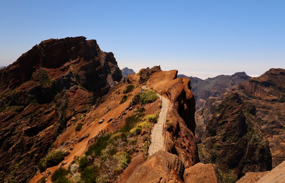
Pico do Areeiro (also spelled Arieiro) is Madeira’s third-highest peak, at 1,818 metres, and the only one of the big summits you can drive to. People go up before dawn to watch the sunrise over a sea of clouds, and hikers start the famous PR1 ridge trail to Pico Ruivo here. Standing at the top is free; parking is paid. Walking PR1 must be booked and paid on the SIMplifica portal: €10.50 for the full route, or €4.50 to the Pedra Rija viewpoint and back (as of October 2026).
Right now in Pico do Areeiro
- Wed7–14°C44–57°F3 mm rain
- Thu8–13°C46–56°F7 mm rain
- Fri8–12°C46–54°F2 mm rain
Tickets and tours for Pico do Areeiro
See all tours for Pico do Areeiro →
From local operators, with prices and reviews; you check availability and book on Viator, our partner. We may earn a commission at no extra cost to you. How we earn money
What it is and why it matters
The mountains at the centre of Madeira are what is left of the old volcanic heart of the island: jagged basalt ridges, deep ravines and pinnacles, often half-hidden in cloud. Pico do Areeiro sits roughly in the middle of the island, and from its summit you see the whole of this landscape at once. On clear days you can make out Porto Santo on the horizon. The summit area belongs to the Madeira Natural Park.
A road built for the summit brings you to within a few minutes’ walk of the top, where there is a large car park, a restaurant and souvenir shop, and the white dome of a Portuguese Air Force radar station, built in 2011. For the rest of the island, see our Madeira travel guide.
What you’ll see
Sunrise above the clouds
The summit is usually above the cloud layer that sits over the north of the island, so at dawn you look down on a white sea with the peaks rising out of it, lit pink and orange. It is the most popular reason to come. Arrive about 45 minutes before sunrise to find a spot on the viewpoints near the car park and watch the light build.
The ridge
From the summit a paved path drops onto the ridge towards Pico Ruivo, the island’s highest point at 1,862 metres. Even a short walk out to the first viewpoints gives you the classic picture: a narrow path with handrails running along a knife-edge between two drops, with the peaks beyond.
The PR1 trail to Pico Ruivo
PR1 Vereda do Areeiro is Madeira’s best-known hike: 6.1 km along and through the ridge to Pico Ruivo, with steep stone steps, exposed sections and tunnels, then 2.8 km down PR1.2 to the car park at Achada do Teixeira. Allow a long half-day.
Trail rules and fees (as of October 2026)
Since 1 January 2026, the regional forestry and nature institute, IFCN, charges and requires booking for its classified trails (Portaria 801/2025, amended by Portaria 48/2026):
- Book online only on SIMplifica (simplifica.madeira.gov.pt), for an entry time slot with about 15 minutes’ tolerance. Same-day booking works only if slots are left.
- Full PR1: €10.50 per visitor over 12 (it also covers PR1.1, PR1.2 and PR1.3). PR1 only as far as the Pedra Rija viewpoint and back: €4.50.
- Free, but still book: children 12 and under, Madeira residents, and people with a disability of 60% or more plus one companion.
- PR1 in 2026: reopened daily on 26 June 2026 after rebuilding, one way only from Pico do Areeiro to Pico Ruivo, via the tunnels; the eastern branch via Pico das Torres is closed. Out-and-back walking is allowed only between Pico do Areeiro and the Pedra Rija viewpoint. Early slots from 07:00 suit sunrise walkers.
- No refunds for your own changes (weather, illness). Only an official IFCN closure gives a refund or new date.
- You do not need a trail booking just to visit the summit and its viewpoints.
Getting there
Most visitors drive: the road climbs from Funchal by way of Poiso, about 40 minutes on a good day, with hairpins and frequent fog. At the top there are two paid car parks, which take bank cards; they fill at sunrise and empty by mid-morning. We found no regular public bus to the summit, so without a car use a taxi or a sunrise tour with hotel pickup. If you walk PR1 one way, book a taxi or tour pickup at Achada do Teixeira before you start: the two trailheads are far apart by road.
When to go and how long to allow
Allow about an hour for sunrise and the summit viewpoints, more if you walk out to Pedra Rija and back, and a long half-day for the full PR1 with the descent to Achada do Teixeira. The weather decides everything: the summit may be in sunshine above the clouds or wrapped in fog and wind while Funchal is sunny. Check the forecast and webcams the evening before. Summer and early autumn give the most stable conditions; winter can bring frost, ice and occasionally snow on the road and the path.
Safety
- Dress for real cold. Madeira’s statistics office recorded an average of 11.4 °C at Pico do Areeiro over 2024, just 6.1 °C in March 2024, and an all-time low of −3.9 °C. At sunrise, with wind, it feels much colder: bring a warm layer, a windproof jacket, a hat and gloves.
- On PR1 wear hiking shoes with grip, carry a headlamp for the tunnels, water and food, and keep to the path. Parts are exposed, with long drops.
- IFCN advises against walking in heavy rain, strong wind, hail or snow, and closes trails after storms, rockfalls and fires. Check IFCN’s trail status page on the morning you walk.
- The road down is long and steep: use low gears and take it slowly in fog.
Combine it with
Pair a sunrise at Areeiro with a levada walk at Ribeiro Frio, down the road past Poiso (the easy PR11 Balcões viewpoint walk, 1.5 km each way), or continue to Santana on the north coast after PR1. If you prefer the easy way to the top of the island, walk PR1.2 from Achada do Teixeira to Pico Ruivo (2.8 km each way). For a sea-cliff contrast on another day, visit Cabo Girão west of Funchal.
Pico do Areeiro FAQ
Do you have to pay to visit Pico do Areeiro?
No, the summit and its viewpoints are free; parking at the top is paid. You only pay IFCN’s trail fee if you walk PR1: €4.50 to Pedra Rija and back, or €10.50 for the full route to Pico Ruivo (as of October 2026).
Is the PR1 from Pico do Areeiro to Pico Ruivo open?
Yes, daily since 26 June 2026, one way from Pico do Areeiro to Pico Ruivo via the tunnels. The branch via Pico das Torres is closed. Book a slot on SIMplifica and check IFCN’s status page on the day.
What time should I arrive for sunrise at Pico do Areeiro?
About 45 minutes before sunrise, to park and find a spot before the light starts. Allow around 40 minutes’ drive from Funchal, more in fog.
How cold is Pico do Areeiro?
Much colder than the coast. Monthly averages can drop to about 6 °C in late winter, and temperatures below freezing have been recorded. At dawn with wind it feels colder still.
Can you get to Pico do Areeiro without a car?
We found no regular public bus. Take a taxi or join a sunrise or hiking tour with hotel pickup; licensed operators also handle the trail booking.
Sources
Researched and last reviewed by TravelerCenter on 3 October 2026. Trail fees, booking and status come from IFCN and Portarias 801/2025 and 48/2026, plus IFCN’s trail status page (2 October 2026); the PR1 reopening date from regional press reporting IFCN; temperatures from Madeira’s regional statistics office (DREM, IPMA data); summit facilities and the radar station from standard references; parking from local press and recent visitor reports. Trail status changes often, so check IFCN on the day.
Data: Weather: MET Norway (CC BY 4.0) · Air quality: OpenAQ · Rates: ECB · Costs: World Bank ICP and price levels · © OpenStreetMap contributors (ODBL) · Wikidata (CC0)