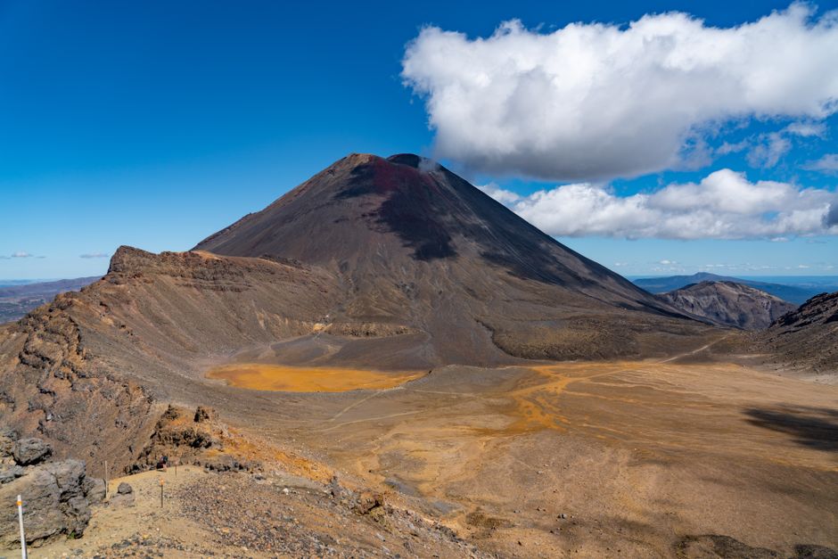
Tongariro National Park, in the center of New Zealand’s North Island, is a high volcanic plateau crowned by three active volcanoes: Tongariro, the cone of Ngāuruhoe (Mount Doom in The Lord of the Rings films) and the broad, snowy massif of Ruapehu, the North Island’s highest peak at 2,797 m (9,177 feet). The mountains are sacred to the local iwi, Ngāti Hikairo ki Tongariro of Ngāti Tūwharetoa. In 1887, Ngāti Tūwharetoa placed the heart of the area under the protection of the Crown, leading to the creation of the national park in 1894, New Zealand’s first and, according to the Department of Conservation (DOC), the fourth in the world. In 1993, it became the first site inscribed on UNESCO’s World Heritage List under the criteria for cultural landscapes, and it is one of the few places listed for both its nature and its culture. Visitors come for the Tongariro Alpine Crossing, often called the best one-day hike in New Zealand, across craters, steaming vents and the vivid Emerald Lakes; for the Tongariro Northern Circuit Great Walk; for skiing on Ruapehu in winter; and for waterfalls, lakes and lava landscapes reached by short walks from Whakapapa Village. Late in 2025, two fires burned large areas near the start of the Crossing; expect blackened ground and early regrowth, and respect the restorative rāhui placed over the area.
Right now in Tongariro National Park (Whakapapa Village)
- Thu3–12°C38–54°F3 mm rain
- Fri5–12°C42–54°F10 mm rain
- Sat5–13°C40–55°F2 mm rain
Top tours in Tongariro National Park
See all tours for Tongariro National Park →
From local operators, with prices and reviews; you check availability and book on Viator, our partner. We may earn a commission at no extra cost to you. How we earn money
Tongariro at a glance
- Best months: late October to April for the Tongariro Alpine Crossing and the Northern Circuit, with January to March the most settled; July to September for skiing on Ruapehu. From May to October, the Crossing is a snowy alpine route.
- Time needed: one long day for the Crossing; two or three days to add short walks around Whakapapa or a ski day; four days for the Northern Circuit.
- Getting there: the park is about 1.5 hours (86 km, 53 miles) from Taupō, 4.5 hours from Auckland and 4.5 hours from Wellington. The bases are Whakapapa Village, National Park Village, Ohakune and Tūrangi.
- Costs (as of October 2026): entry is free; booking the Crossing is free; DOC says shuttle fees are about NZ$40 (about US$22). Northern Circuit huts cost NZ$66 a night for international adults in season.
- Before you go: entry rules, the NZeTA and visitor levy, biosecurity and driving rules are in our New Zealand travel guide.
The Tongariro Alpine Crossing: bookings, parking and shuttles (as of October 2026)
The Crossing is a one-way, 20.2 km (12.5-mile) hike from Mangatepōpō Road end to Ketetahi Road end, rated by DOC as requiring high fitness, with steep and uneven sections. It takes 7 to 8 hours from November to April and about 9 hours from May to October.
- Booking: DOC recommends a free track booking for everyone using any part of the Crossing, and you must have a booking to use a shuttle or guided walk service.
- Parking: from Labour Weekend (late October) to 30 April, parking at the road ends is limited to four hours, which is not enough to complete the Crossing. DOC states there is no parking for Crossing hikers at the Mangatepōpō car park in summer; a private car park operates near the Ketetahi end. Don’t park on the side of state highways.
- Shuttles: DOC says the best way to do the Crossing is by shuttle. Operators run from Whakapapa, National Park Village, Tūrangi, Ohakune, Taupō and other towns, dropping you at Mangatepōpō and collecting you at Ketetahi; book through the local i-SITE visitor centers or operators. Part of the shuttle fee (about NZ$40) supports DOC conservation.
- Weather warnings: in summer, DOC applies a “Not Recommended Today” notice when the forecast for Red Crater exceeds set limits (for example, average winds of 55 km/h or more, gusts of 70 km/h or more, wind chill of −10 °C or colder, or heavy rain or snow). It is assessed at 6 a.m. daily and posted at the road end, on the NIWA forecast and to shuttle operators. Many shuttles won’t run when it applies.
- Winter (May to October): the track is covered in snow and ice. It is suitable only for people with alpine skills, an ice axe, crampons, a helmet and avalanche gear, or on a guided trip. Shuttles generally don’t operate in winter, but guided trips include transport.
The route
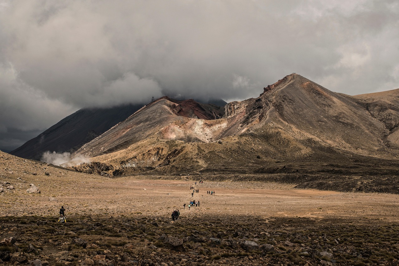
The track begins at 1,120 m (3,675 feet) on a boardwalk through the Mangatepōpō Valley, past old lava flows (the first 5.4 km is shared with the Soda Springs walk). At the head of the valley, a steady climb of about 350 m (1,150 feet) up the “Devil’s Staircase” reaches the flat South Crater. The climb continues to Red Crater, the highest point at 1,886 m (6,188 feet). A steep descent on loose volcanic scree, a major slip hazard, leads to the Emerald Lakes (Ngā Rotopounamu), then across Central Crater to the Blue Lake (Te Wai Whakaata o Te Rangihīroa) and down past Ketetahi’s steaming slopes through tussock and forest to the road end. Manaaki Rangers greet visitors every day from November to April and share the stories of the place. All waterways here, including the lakes, are sacred to Ngāti Hikairo ki Tongariro, and DOC asks walkers not to touch or enter any of them.
Proposed access charge
The Tongariro Alpine Crossing is one of four sites where the government is investigating an access charge for international visitors, under the Conservation Amendment Bill introduced in May 2026. It was not law in October 2026 and no charge applied; check DOC before a 2027 visit.
Safety: volcanoes, alpine weather and geothermal ground
- Volcanic activity: the Crossing traverses an active volcanic area, and eruptions can happen without warning. GeoNet’s volcanic alert levels in October 2026 were Level 0 (no unrest) for Tongariro and Ngāuruhoe and Level 1 (minor unrest) for Ruapehu. Check GeoNet before you go and follow signs about volcanic hazard zones; if you’re uncomfortable with the risk, DOC suggests choosing a different track.
- Alpine weather: very cold temperatures, strong winds, heavy rain and poor visibility are common even in summer, and snow can fall at any time. DOC says Red Crater is at least 10 °C colder than Taupō on a calm day; subtract another 2 °C for every 10 km/h of wind. Be prepared to turn back.
- Geothermal hazards: stay on the marked track near the Emerald Lakes and Ketetahi; steam vents are very hot and the ground can be unstable.
- Water: carry 2 to 3 liters per person; water along the track is not safe to drink.
- Fitness and daylight: the Crossing is long and steep. Start early, carry a head torch and know the time you must leave by to catch your shuttle.
- Fire-affected areas: stay on the tracks, don’t enter burned areas, clean your shoes and gear to avoid spreading weeds, and take all rubbish home.
- Drones: prohibited without a permit.
- Emergencies: call 111; cell coverage is patchy. Carry a personal locator beacon on longer trips.
Top things to see in Tongariro National Park
The Tongariro Alpine Crossing
The park’s headline hike, described above, is a day of extraordinary colors: red and black scoria, yellow sulfur, the jade-green Emerald Lakes and the deep blue of the Blue Lake, with views of Ngāuruhoe’s cone, Ruapehu and, on clear days, Lake Taupō and Mount Taranaki. Go in summer with a booking and a shuttle, or with a guide in winter.
The Tongariro Northern Circuit
This Great Walk loops 35.5 km (22 miles) around Ngāuruhoe in 3 to 4 days, combining part of the Crossing with the desert-like Rangipō Desert, the Oturere Valley’s lava fields, the Waihohonu Valley and the Tama Lakes. It was not operating as a Great Walk while Oturere Hut was being replaced and returns for the 2026/27 season, from 23 October 2026 to 30 April 2027, when huts and campsites must be booked.
| Northern Circuit fees, per night | Season (23 Oct–30 Apr) | Off season (1 May–22 Oct) |
|---|---|---|
| Hut, international adult | NZ$66 | NZ$25 |
| Hut, New Zealand adult | NZ$44 | NZ$25 |
| Campsite, international adult | NZ$28 | NZ$10 |
| Campsite, New Zealand adult | NZ$19 | NZ$10 |
Children pay half; international children are charged from birth and New Zealand children from age 5. Proof of eligibility is required for the New Zealand rate.
Whakapapa Village and Taranaki Falls
The park’s village, on the northwestern slopes of Ruapehu at about 1,120 m, has the Tongariro National Park Visitor Centre, a few places to stay and the start of several easy walks. The Taranaki Falls loop (about 2 hours) passes a 20 m (66-foot) waterfall pouring over an old lava flow, with views of Ngāuruhoe. The longer Tama Lakes track continues to two explosion craters between Ngāuruhoe and Ruapehu. The short Whakapapa Nature Walk introduces the alpine plants.
Ruapehu and its ski areas
Ruapehu is the North Island’s biggest ski mountain, with the Whakapapa ski area on its northwestern side, above the village, and Tūroa on the southwestern side, above Ohakune. The season usually runs from about July to October, depending on snow. In summer, a chairlift at Whakapapa may carry sightseers up the mountain; check the operator. Ruapehu’s summit crater lake is out of bounds to casual walkers because of the volcanic hazard.
Ohakune and the Old Coach Road
On the southern side of the park, the town of Ohakune (famous for its giant carrot sculpture) is the base for Tūroa and for the Ohakune Old Coach Road, a cycle and walking trail along a historic road past the restored Hāpuawhenua and Taonui viaducts, part of the Mountains to Sea Cycle Trail.
Other things to do in and around Tongariro
- Mountain biking: the Old Coach Road, the Fishers Track and the Mountains to Sea Trail.
- Fishing: the Tongariro River, near Tūrangi, is world-famous for trout; a license is required.
- Whitewater rafting and kayaking on the Tongariro River.
- Scenic flights over the volcanoes and crater lakes.
- The Northern Explorer train crosses the park on the North Island Main Trunk line, stopping at National Park Village, with views of the Raurimu Spiral.
- Lake Rotopounamu: a 2-hour loop through native forest around a hidden lake near Tūrangi.
Getting there
- From Taupō: about 1.5 hours via Tūrangi and State Highway 47 to Whakapapa or National Park Village. DOC lists Taupō as 86.5 km from the park.
- From Auckland or Wellington: about 4.5 hours by car. The Desert Road (State Highway 1 east of the park) can close in winter snow.
- By train: the Northern Explorer between Auckland and Wellington stops at National Park Village and Ohakune.
- By coach: InterCity buses stop at National Park Village and Tūrangi.
Around the park
Distances by road from the Crossing, according to DOC: Whakapapa 10.4 km, National Park Village 13.5 km, Tūrangi 36.7 km, Ohakune 48 km. Shuttles link the villages with the trailheads in summer, but otherwise you’ll need a car. Fill up and buy supplies in Tūrangi, National Park Village or Ohakune.
When to go and how long to stay
The volcanic plateau has a cool mountain climate, much harsher than Taupō’s lakeside weather. Summer (December to February) brings warm days in the villages but cool to cold conditions and strong winds on the tops; this is the main hiking season. Autumn (March to May) often has stable, clear weather. Winter (June to August) brings snow, ice and the ski season; the Crossing becomes an alpine route. Spring (September to November) is windy and changeable, with snow lingering on the tops.
| Month | Average high | Average low | Rain | Rain days (≥1 mm) |
|---|---|---|---|---|
| Jan | 23 °C (73 °F) | 12 °C (53 °F) | 73 mm (2.9 in) | 7 |
| Feb | 23 °C (73 °F) | 12 °C (53 °F) | 65 mm (2.6 in) | 6 |
| Mar | 21 °C (69 °F) | 10 °C (50 °F) | 66 mm (2.6 in) | 7 |
| Apr | 17 °C (63 °F) | 7 °C (45 °F) | 77 mm (3.0 in) | 8 |
| May | 14 °C (58 °F) | 5 °C (41 °F) | 79 mm (3.1 in) | 9 |
| Jun | 12 °C (53 °F) | 3 °C (38 °F) | 93 mm (3.7 in) | 11 |
| Jul | 11 °C (52 °F) | 2 °C (36 °F) | 100 mm (3.9 in) | 11 |
| Aug | 12 °C (54 °F) | 3 °C (37 °F) | 89 mm (3.5 in) | 12 |
| Sep | 14 °C (57 °F) | 5 °C (40 °F) | 79 mm (3.1 in) | 11 |
| Oct | 16 °C (61 °F) | 6 °C (44 °F) | 74 mm (2.9 in) | 10 |
| Nov | 18 °C (65 °F) | 8 °C (46 °F) | 65 mm (2.5 in) | 9 |
| Dec | 21 °C (70 °F) | 11 °C (51 °F) | 88 mm (3.5 in) | 10 |
| Year | 17 °C (62 °F) | 7 °C (45 °F) | 948 mm (37.3 in) | 110 |
NIWA’s published 1991–2020 normals don’t include a station inside the park, so this table shows Taupō, about 86 km (53 miles) to the north at about 400 m (1,300 feet). Whakapapa Village, at about 1,120 m, is several degrees colder and considerably wetter, and Red Crater is at least 10 °C colder than Taupō, according to DOC.
Tongariro in one day
Take an early shuttle to Mangatepōpō, hike the Crossing, and relax afterwards in National Park Village or soak in hot pools at Tokaanu near Tūrangi.
Three days or more
Day one the Crossing; day two Taranaki Falls and the Tama Lakes from Whakapapa; day three the Old Coach Road by bike or the Tongariro River. Or book the Northern Circuit for four days.
Where to stay
- Whakapapa Village: a few hotels and lodges, a holiday park and the visitor center, right on the mountain.
- National Park Village: lodges, motels and backpacker hostels, the main shuttle hub for the Crossing.
- Ohakune: the biggest town nearby, with ski lodges, motels and restaurants; busiest in winter.
- Tūrangi: motels and fishing lodges near Lake Taupō, 40 minutes from the Crossing.
- Huts and campsites: on the Northern Circuit, booked through DOC in season.
Prices include 15% GST and rise in the ski season and summer holidays.
Typical costs in Tongariro National Park
| Item (as of October 2026) | New Zealand dollars | About US dollars |
|---|---|---|
| National park entry and Crossing booking | Free | Free |
| Crossing shuttle (DOC estimate) | about NZ$40 | about US$22 |
| Northern Circuit hut, international adult, per night in season | NZ$66 | US$37 |
| Northern Circuit campsite, international adult, per night in season | NZ$28 | US$16 |
| Guided winter Crossing | about NZ$250–350 | about US$140–195 |
| Ski lift pass, adult, one day | about NZ$140–180 | about US$80–100 |
| Lodge or motel room, per night | about NZ$150–280 | about US$85–155 |
Hut and campsite fees are official DOC figures, and the shuttle cost is DOC’s estimate. Guiding, lift-pass and accommodation prices are typical ranges, not official prices. Conversions use about US$0.56 to NZ$1.
Practical tips for Tongariro National Park
- Book early: shuttles and accommodation fill on fine summer days; make your free DOC track booking first.
- Have a plan B: if “Not Recommended Today” applies, do the Taranaki Falls or Tama Lakes walks instead, or wait a day.
- Toilets: there are toilets at intervals along the Crossing, but they are busy; carry toilet paper.
- Respect the mountains: don’t climb onto Ngāuruhoe’s summit or touch the lakes; they are sacred to Ngāti Hikairo.
- Volcanic alerts: check GeoNet the day before and on the morning of your hike.
What to pack for Tongariro National Park
Sturdy hiking boots, a waterproof and windproof jacket and pants, warm layers (merino or fleece), a hat, gloves, sunscreen and sunglasses, 2 to 3 liters of water, lunch and snacks, toilet paper, a head torch, a phone and a personal locator beacon. In winter, add crampons, an ice axe, a helmet and avalanche equipment, or go with a guide who supplies them.
Tongariro National Park travel FAQ
Do I need to book the Tongariro Alpine Crossing?
DOC recommends a free booking for everyone, and you must book to use a shuttle or guided walk. There is no cost to book.
Can I park at the start of the Tongariro Alpine Crossing?
Not for the whole hike in summer. From Labour Weekend to 30 April, parking at the road ends is limited to four hours, so most hikers use a shuttle. Don’t park on the side of state highways.
How long does the Tongariro Alpine Crossing take?
7 to 8 hours from November to April and about 9 hours from May to October, for 20.2 km one way, according to DOC.
Is the Tongariro Alpine Crossing safe?
It is a demanding alpine hike in an active volcanic area. Check the weather, the “Not Recommended Today” notice and GeoNet’s volcanic alert level, carry warm gear and water, and turn back if conditions worsen.
What is the volcanic alert level at Tongariro?
In October 2026, GeoNet set Tongariro and Ngāuruhoe at Level 0 (no unrest) and Ruapehu at Level 1 (minor unrest). Check GeoNet for the latest.
Can I do the Tongariro Alpine Crossing in winter?
Only with alpine skills and equipment, or with a guide. From May to October, the track is snowy and icy with avalanche risk, and shuttles generally don’t run.
Is Mount Ngāuruhoe really Mount Doom?
Yes, Ngāuruhoe was used as Mount Doom in Peter Jackson’s films. Climbing it is discouraged out of respect for its cultural significance and because of loose rock.
When does the Tongariro Northern Circuit open?
It returns as a Great Walk for the 2026/27 season, from 23 October 2026 to 30 April 2027, after Oturere Hut was replaced. Huts cost NZ$66 per night for international adults.
Where should I stay for the Tongariro Alpine Crossing?
National Park Village and Whakapapa are closest; Tūrangi, Ohakune and Taupō also have shuttles.
What happened in the 2025 fires?
Two fires in late 2025 burned significant areas near the start of the Crossing. Ngāti Hikairo ki Tongariro have placed a 10-year restorative rāhui over the area; stay on the tracks and clean your gear.
Plan your trip
Partner links: TravelerCenter may earn a commission if you book, at no extra cost to you.
Sources · last reviewed 5 October 2026
Researched and last reviewed on 5 October 2026. Tongariro Alpine Crossing distance, times, booking, parking, shuttles and shuttle fee, the “Not Recommended Today” thresholds, winter conditions, the 2025 fires and rāhui, the route description, distances to nearby towns, and the park’s history; the Northern Circuit’s season, fees and Oturere Hut status come from the Department of Conservation; the proposed access charge from DOC’s 2026 consultation page; volcanic alert levels from GeoNet; climate from NIWA’s 1991–2020 normals for Taupō (used as the nearest published station); exchange rates from the European Central Bank. Ruapehu’s height, ski-season timing, short-walk times, drive times from Auckland and Wellington, and guiding, lift-pass and accommodation prices are general references and flagged for checking. Prices, schedules and conditions change, so check the official sites before you go. For entry rules, biosecurity and driving, see our New Zealand travel guide.
Data: Weather: MET Norway (CC BY 4.0) · Rates: ECB · Costs: World Bank ICP and price levels · Wikidata (CC0)