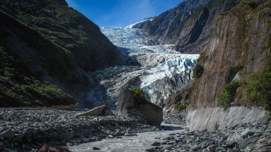
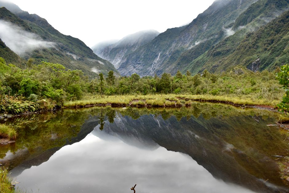
Westland Tai Poutini National Park stretches from the highest peaks of the Southern Alps down to the wild beaches of the South Island’s West Coast. Its stars are two of the most famous glaciers in the world, Franz Josef Glacier/Kā Roimata o Hine Hukatere and Fox Glacier/Te Moeka o Tuawe, rivers of ice that descend from huge snowfields through temperate rainforest almost to sea level. The Department of Conservation (DOC) notes that Franz Josef’s terminal face is less than 300 m (985 feet) above sea level, one of only three glaciers in the world this close to the coast. The park, established in 1960, is split by the Alpine Fault: to the east, mountains rise abruptly with deep gorges and icefalls; to the west, lowland rainforest, lakes, wetlands and lagoons run to the Tasman Sea. It is part of Te Wāhipounamu – South West New Zealand World Heritage Area. Both glaciers have retreated dramatically in recent decades, so you can no longer simply walk up to the ice: valley tracks lead to viewpoints, and the only way onto the glaciers is a guided heli-hike or a scenic flight with a snow landing. The two small villages at their feet, Franz Josef/Waiau and Fox Glacier/Weheka, are friendly bases with hot pools, kiwi encounters and the mirror-calm Lake Matheson.
Right now in Westland Tai Poutini National Park (Franz Josef) (Franz Josef)
- Thu12–18°C53–65°FCloudy
- Fri9–18°C48–64°FPartly cloudy
- Sat12–15°C54–58°F24 mm rain
Top tours in Westland Tai Poutini National Park (Franz Josef)
See all tours for Westland Tai Poutini National Park (Franz Josef) →
From local operators, with prices and reviews; you check availability and book on Viator, our partner. We may earn a commission at no extra cost to you. How we earn money
Westland Tai Poutini at a glance
- Best months: November to April for longer days and walking; late autumn and winter (May to August) often bring the clearest, most stable days for flights and mountain views. Rain is possible on any day.
- Time needed: two nights to allow for weather on flights and heli-hikes; three to add Ōkārito or Lake Matheson at dawn.
- Getting there: the only road is State Highway 6. Franz Josef is about 2 hours (135 km, 84 miles) south of Hokitika, 3.5 hours from Wānaka and about 5 hours from Queenstown; Fox Glacier is 25 km (16 miles) further south. The nearest commercial airport is Hokitika, with daily flights from Christchurch.
- Costs (as of October 2026): entry and the valley walks are free; heli-hikes cost roughly NZ$550–750 (about US$310–420).
- Before you go: entry rules, the NZeTA and visitor levy, biosecurity and driving rules are in our New Zealand travel guide.
Glacier access: heli-hikes, flights and valley walks (as of October 2026)
The glaciers have been retreating for most of the past century, with occasional advances. As the ice thinned, the lower glaciers became unstable, with collapsing ice, rockfall from the steep valley walls and sudden floods. Guided walks onto the ice from the valley floor stopped years ago, and the valley tracks now end at viewpoints well back from the terminal faces; DOC says the glacier viewpoints are hundreds of meters from the ice.
- On the ice: the only way is a guided heli-hike, in which a helicopter lands you on the upper glacier for two to three hours of walking with a guide, crampons and equipment provided, exploring ice caves, arches and crevasses where conditions allow. Fox Glacier Guiding and Franz Josef Glacier Guides run them from the villages.
- Scenic flights: helicopters and ski planes fly over both glaciers and the névé (snowfields), many with a snow landing near the main divide, and some include views of Aoraki/Mount Cook.
- Valley walks: free DOC tracks lead up both glacier valleys to viewpoints (see below). The tracks can be closed by rockfall, floods or river changes; check the daily glacier access update posted by Glacier Country Tourism and the DOC visitor center in Franz Josef.
- Weather: flights and heli-hikes depend on clear weather and are often canceled; book for your first morning and keep a spare day so you can rebook.
Safety: rain, rivers, glacier hazards and sandflies
- Heavy rain: DOC says the park lies in the path of the prevailing westerlies and can receive up to five meters (16 feet) of rain a year. Downpours can flood the valleys within minutes; obey all signs and never cross barriers.
- River surges: glacial rivers can be dammed by ice falls, and when the dam bursts, a surge of water and ice floods the valley. Stay on the marked tracks and out of the riverbed.
- Rivers: never attempt to cross the Waiho or Callery rivers on foot; they are very swift, cold and dangerous. Use the road bridges.
- Rapidly changing weather: the walks are in an alpine region; carry warm, waterproof clothing at all times.
- Rockfall: the valley walls are steep and unstable; don’t stop under cliffs, and respect closures.
- Sandflies: DOC says they are prevalent. Bring a strong insect repellent and cover up.
- Driving: State Highway 6 is winding, with many one-lane bridges and occasional slips that close the road after heavy rain; drive on the left and check road status before long legs. Fuel is limited between towns.
- Kea: don’t feed these endangered alpine parrots; it harms their health and behavior.
- Emergencies: call 111; mobile coverage is limited outside the villages.
Top things to see in Westland Tai Poutini National Park
Franz Josef Glacier/Kā Roimata o Hine Hukatere
The Māori name means “the tears of Hine Hukatere”: in the Ngāi Tahu story, the glacier formed from the frozen tears of a young woman whose lover fell from the mountains. From Franz Josef village, drive south over the Waiho River bridge and turn left onto the Franz Josef Glacier Access Road (unsealed but suitable for cars and campervans) to the glacier car park, which has flush toilets but no rubbish bins. From there:
- Franz Josef Glacier Walk (Kā Roimata o Hine Hukatere Walk): an easy, popular walk up the riverbed and moraine to the end of the formed track, with views of the glacier’s terminal; allow about 1.5 hours return.
- Sentinel Rock Walk: a short, steady climb of 20 minutes (900 m return) to a rocky knoll with views of the glacier, the valley and the Waiho River.
- Roberts Point Track: a demanding 5 to 5.5-hour return (11–12.3 km) track for fit hikers, past Hende’s Hut and swing bridges to a lookout high above the glacier.
- Alex Knob Track: a full-day, 17.2 km (10.7-mile) return climb of about 8 hours through changing forest to views of the glacier, the Alps and the sea.
Fox Glacier/Te Moeka o Tuawe
About 13 km (8 miles) long, Fox Glacier is one of the longest in the park. The Fox Glacier South Side Walkway/Cycleway follows the south bank of the Fox River through old podocarp rainforest: drive south for 2 km from the village, cross the Fox River bridge and park on the left. The first glacier viewpoint is about 40 minutes along; the full walk is 6.4 km (4 miles) return, about 2 hours, and you can cycle as far as the old car park, where bikes must be left. DOC warns not to go past the end point because of extreme flood hazard. Te Kopikopiko o te Waka (Fox Glacier Viewpoint) gives a panorama of the Southern Alps and tells the Ngāi Tahu creation story.
Lake Matheson/Te Ara Kairaumati
Six kilometers from Fox Glacier village, this small, dark lake formed by the glacier during the last ice age famously reflects Aoraki/Mount Cook and Mount Tasman on calm, clear days. The 4.4 km (2.7-mile) loop takes about 1.5 hours and is suitable for all fitness levels; the best reflections come at dawn or in the still evening, from the “View of Views” platform. A café is at the car park.
Gillespies Beach and Peak Viewpoint
West of Fox Glacier, a gravel road leads to Gillespies Beach, an old gold-mining site with a miners’ cemetery, coastal walks and a track to a fur-seal colony at Galway Beach (about 3.5 hours return). Peak Viewpoint, 9 km from Fox village toward the coast, gives a panoramic view of the Fox névé and the Alps, outstanding at sunset on a clear evening.
Ōkārito
On the coast north of Franz Josef, the tiny village of Ōkārito sits beside the largest unmodified wetland in New Zealand. Kayak the lagoon, walk to the Ōkārito Trig for views of the Alps and the coast, take a guided night walk to look for the rare Ōkārito kiwi (rowi), the country’s rarest kiwi, or join a boat tour from Whataroa to New Zealand’s only nesting colony of kōtuku (white herons), open in the breeding season.
Lake Mapourika
Ten minutes north of Franz Josef, the largest lake in the park is famous for its reflections and is a lovely spot for kayaking, fishing, swimming in summer and camping.
Other things to do in Glacier Country
- Glacier Hot Pools: rainforest hot pools in Franz Josef village, perfect after a wet day.
- West Coast Wildlife Centre: in Franz Josef, a kiwi-hatching center where you can see rowi and Haast tokoeka kiwi.
- Skydiving: with views of the glaciers, mountains and sea.
- Copland Track: a 1-day hike (about 7 hours one way) to Welcome Flat Hut, with natural hot pools in the forest, south of Fox Glacier; hut bookings required.
- Gold fossicking: a recreational gold-panning area on the Waiho River bed between the Callery Gorge swing bridge and the road bridge; no permit is needed.
- Callery Gorge and Tatare Tunnels walks: short history walks near Franz Josef through old gold-mining and water-race tunnels (bring a torch).
Getting there
- From the north: Hokitika (with daily flights from Christchurch) is about 2 hours north of Franz Josef; Greymouth, the end of the TranzAlpine train, about 2.5 hours. DOC lists Fox Glacier as 171 km south of Hokitika.
- From the south: Wānaka and Queenstown via the Haast Pass, about 3.5 and 5 hours.
- By coach: InterCity runs along the West Coast, stopping at both villages.
- Self-drive: the most common option, as part of a South Island loop. Carry chains for the Haast Pass in winter, and check NZTA for slips and closures after heavy rain.
Around the park
Franz Josef and Fox Glacier are 25 km (about 30 minutes) apart. Both villages have accommodation, fuel, a small grocery store, cafés and restaurants, and the guiding and flight companies have offices on the main street. Most walks start within 5 to 15 minutes’ drive of the villages. The DOC Westland Tai Poutini National Park Visitor Centre is at 69 Cron Street, Franz Josef, with weather and track information.
When to go and how long to stay
The West Coast’s climate is mild, wet and changeable, with rain spread through the year and little difference between seasons at low altitude. Summer (December to February) brings highs around 19–20 °C (66–68 °F), long days and the most visitors and sandflies. Autumn (March to May) and winter (June to August) often have long settled spells with crisp, clear mornings and snow down to the bush line, the best conditions for mountain views and flights. Spring (September to November) is the wettest and windiest. Whatever the season, the forecast can change quickly, so plan flexibly.
| Month | Average high | Average low | Rain | Rain days (≥1 mm) |
|---|---|---|---|---|
| Jan | 20 °C (67 °F) | 12 °C (54 °F) | 257 mm (10.1 in) | 12 |
| Feb | 20 °C (68 °F) | 12 °C (54 °F) | 192 mm (7.5 in) | 11 |
| Mar | 19 °C (66 °F) | 11 °C (51 °F) | 213 mm (8.4 in) | 12 |
| Apr | 17 °C (62 °F) | 9 °C (47 °F) | 245 mm (9.6 in) | 13 |
| May | 15 °C (58 °F) | 6 °C (44 °F) | 253 mm (10.0 in) | 15 |
| Jun | 12 °C (54 °F) | 4 °C (40 °F) | 261 mm (10.3 in) | 15 |
| Jul | 12 °C (54 °F) | 3 °C (38 °F) | 228 mm (9.0 in) | 14 |
| Aug | 13 °C (55 °F) | 4 °C (40 °F) | 247 mm (9.7 in) | 15 |
| Sep | 14 °C (57 °F) | 6 °C (43 °F) | 245 mm (9.6 in) | 17 |
| Oct | 15 °C (59 °F) | 8 °C (46 °F) | 285 mm (11.2 in) | 18 |
| Nov | 16 °C (61 °F) | 9 °C (48 °F) | 223 mm (8.8 in) | 15 |
| Dec | 18 °C (65 °F) | 11 °C (52 °F) | 272 mm (10.7 in) | 16 |
| Year | 16 °C (60 °F) | 8 °C (46 °F) | 2,921 mm (115.0 in) | 172 |
NIWA’s published 1991–2020 normals don’t include a station inside the park, so this table shows Hokitika, about 130 km (80 miles) north of Franz Josef on the coast. Temperatures in the glacier villages are similar, but rainfall is far higher: DOC says the park can receive up to 5,000 mm (197 in) a year.
Glacier Country in one day
Start with a morning heli-hike or scenic flight at Franz Josef (weather permitting), walk to the Franz Josef glacier viewpoint and Sentinel Rock, drive to Fox Glacier for the South Side Walkway, and finish with sunset at Lake Matheson or Peak Viewpoint.
Two or three days
Keep a spare morning for a weather-delayed flight; add Ōkārito, the Glacier Hot Pools, the West Coast Wildlife Centre and Lake Matheson at dawn, or the Roberts Point Track.
Where to stay
- Franz Josef/Waiau: the larger village, with motels, lodges, hotels, hostels and holiday parks.
- Fox Glacier/Weheka: quieter, with motels, lodges and a holiday park; closest to Lake Matheson.
- Ōkārito and Lake Mapourika: a few lodges, holiday homes and a campground for a peaceful stay.
- DOC campsites: basic and serviced sites along State Highway 6.
Prices include 15% GST. Book ahead in summer, when the villages fill with road-trippers.
Typical costs in Westland Tai Poutini
| Item (as of October 2026) | New Zealand dollars | About US dollars |
|---|---|---|
| National park entry and valley walks | Free | Free |
| Gold fossicking in the Waiho River bed | Free, no permit | Free |
| Heli-hike on Franz Josef or Fox Glacier | about NZ$550–750 | about US$310–420 |
| Scenic helicopter flight with snow landing | about NZ$300–500 | about US$170–280 |
| Glacier Hot Pools, adult | about NZ$40–50 | about US$22–28 |
| Motel room in Franz Josef or Fox, per night | about NZ$150–280 | about US$85–155 |
Park and fossicking information comes from DOC. Heli-hike, flight, hot pool and motel prices are typical ranges from operators and booking sites, not official prices. Conversions use about US$0.56 to NZ$1.
Practical tips for Westland Tai Poutini
- Time zone: New Zealand Daylight Time (UTC+13) from 27 September 2026 to 4 April 2027.
- Book flights for your first morning: if canceled, you still have time to rebook.
- Check the daily glacier access update before walking up the valleys.
- Fuel up: fill the tank in Franz Josef, Fox, Haast or Hokitika; distances between pumps are long.
- Westland Anniversary Day is observed on Monday 30 November 2026; some services may be reduced.
- Free things: the glacier valley walks, Lake Matheson, Gillespies Beach, gold fossicking and Peak Viewpoint.
What to pack for Westland Tai Poutini
A good rain jacket and rain pants, warm layers, waterproof walking shoes or boots, a hat and gloves (the down-draft off the glacier is cold), insect repellent for sandflies, sunscreen and sunglasses for flights over snow, a swimsuit for the hot pools and a head torch for the tunnel walks. Heli-hike operators provide boots, crampons and jackets.
Westland Tai Poutini National Park travel FAQ
Can you walk on Franz Josef Glacier?
Only on a guided heli-hike, which flies you onto the upper glacier. The valley walks end at viewpoints hundreds of meters from the ice.
Can you still see Fox Glacier?
Yes, from the Fox Glacier South Side Walkway (6.4 km return, about 2 hours), Te Kopikopiko o te Waka viewpoint and Peak Viewpoint, or from a scenic flight. Lake Matheson gives views of the mountains above it.
Franz Josef or Fox Glacier: which is better?
Franz Josef village has more accommodation and activities; Fox is quieter and has Lake Matheson. Both offer heli-hikes and valley walks, and they are 30 minutes apart, so many visitors see both.
Why are the glaciers retreating?
Warmer temperatures and changing snowfall have caused both glaciers to retreat for most of the past century, with occasional short advances. The retreat has made the lower ice unstable, which is why walks onto the ice from the valley floor stopped.
Are heli-hikes canceled in bad weather?
Often. Flights need clear weather; book early in your stay and allow a spare day.
When is the best time to visit the glaciers?
November to April for longer days and walking, while autumn and winter often bring the clearest mountain views. Rain is possible year-round.
How long is the Lake Matheson walk?
A 4.4 km loop of about 1.5 hours, suitable for all fitness levels. Go at dawn for the best reflections.
How do I get to Franz Josef?
By road on State Highway 6, about 2 hours from Hokitika (with flights from Christchurch), or about 3.5 hours from Wānaka over the Haast Pass. InterCity coaches stop in both villages.
Are there sandflies at Franz Josef?
Yes; DOC says they are prevalent in the park. Use repellent and cover up, especially at dawn and dusk and by lakes and rivers.
Is it safe to walk in the glacier valleys?
On the marked tracks and within the barriers, yes. Floods, river surges and rockfall are real hazards, so check the daily access update and never cross a closure or barrier.
Plan your trip
Partner links: TravelerCenter may earn a commission if you book, at no extra cost to you.
Sources · last reviewed 5 October 2026
Researched and last reviewed on 5 October 2026. Park facts (World Heritage status, establishment, the Alpine Fault, Franz Josef’s low terminal), rainfall, hazards (river surges, flooding, the Waiho and Callery rivers), sandflies, kea, gold fossicking, road access via State Highway 6, Hokitika as the nearest commercial airport, the Fox Glacier South Side Walkway, Fox Glacier’s length, Lake Matheson and Peak Viewpoint distances, Sentinel Rock, and the visitor center come from the Department of Conservation; guided heli-hike access, the daily glacier access update and walk times for Lake Matheson, Roberts Point, Alex Knob and Canavans Knob from Glacier Country Tourism (the regional tourism organization); climate from NIWA’s 1991–2020 normals for Hokitika (used as the nearest published station); the Westland Anniversary Day date from Employment New Zealand; exchange rates from the European Central Bank. The Franz Josef Glacier Walk time, drive times, the Copland and Gillespies Beach walk times, Ōkārito and white heron details, and heli-hike, flight, hot pool and motel prices are general references and flagged for checking. Prices, schedules and access change, so check the official sites before you go. For entry rules, biosecurity and driving, see our New Zealand travel guide.
Data: Weather: MET Norway (CC BY 4.0) · Sea temperature: NOAA CoastWatch · Rates: ECB · Costs: World Bank ICP and price levels · Wikidata (CC0)