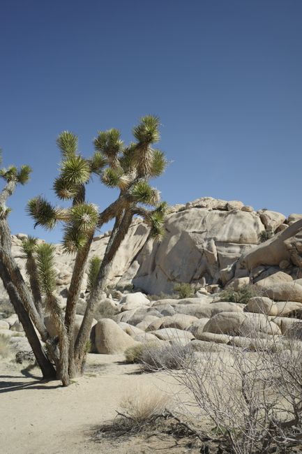
Joshua Tree National Park protects nearly 800,000 acres of Southern California desert where two very different deserts meet: the higher, cooler Mojave in the west, studded with spiky Joshua trees and great piles of golden granite boulders, and the lower, hotter Colorado Desert in the east, with cholla cactus gardens and palm oases. About 140 miles (225 km) east of Los Angeles and an hour from Palm Springs, it is a favorite for easy hikes among the rocks, world-class climbing, sunsets at Keys View and some of the darkest night skies near a big city. There are no hotels, restaurants, gas stations or drinking water in most of the park, and summers are dangerously hot, so come prepared, ideally between October and May. No reservation is needed to enter, and the $100 non-resident fee does not apply here.
Right now in Joshua Tree National Park (Jumbo Rocks)
- Wed22–31°C71–87°FClear
- Thu22–32°C72–89°FClear
- Fri21–30°C71–85°FClear
- Mon 12 Oct Columbus Day
- Mon 12 Oct Indigenous Peoples' Day · regional holiday in California
Top tours in Joshua Tree National Park
See all tours for Joshua Tree National Park →
From local operators, with prices and reviews; you check availability and book on Viator, our partner. We may earn a commission at no extra cost to you. How we earn money
Joshua Tree at a glance
- Best months: October to May, with spring and fall highs around 85 °F (29 °C) and wildflowers from February to April after a wet winter. Summer days pass 100 °F (38 °C).
- Time needed: one full day to drive through and walk the short trails; two or three days for longer hikes, climbing and stargazing.
- Getting there: about 140 miles (225 km) east of Los Angeles, roughly 2.5–3 hours; about an hour from Palm Springs. You need a car.
- Fees (as of October 2026): $30 per car for 7 days, card only at the entrance stations. No reservation and no non-resident surcharge.
- Before you go: entry rules for international visitors, driving and tipping are in our United States travel guide.
Entrance fees and passes (as of October 2026)
The park is open 24 hours a day, every day; when the entrance stations are not staffed at night, the gates stay open. The West and North entrance stations take cards only; you can pay cash at the visitor centers, or buy a digital pass on Recreation.gov at no extra cost and save it on your phone before you arrive, as there is little or no signal in the park.
| Pass | Price | What it covers |
|---|---|---|
| Private vehicle | $30 | One non-commercial vehicle and passengers, day of purchase plus 6 days |
| Motorcycle | $25 | 7 days |
| Per person (foot or bike) | $15 | 7 days |
| Joshua Tree annual pass | $55 | This park, 12 months; US citizens and residents |
| America the Beautiful pass | $80 residents / $250 non-residents | All national parks and federal lands for 12 months |
For international visitors: the extra $100-per-person non-resident fee introduced in 2026 applies at 11 of the busiest national parks, including Yosemite, Sequoia and Kings Canyon and the Grand Canyon, but not at Joshua Tree. If your trip includes one of those parks too, the $250 non-resident America the Beautiful pass covers them all. US residents enter free on the remaining 2026 fee-free days, October 27 and November 11.
Reservations, crowds and closures
There is no reservation system to enter the park, and none had been announced for 2027 as of October 2026. Most visitors come between October and May, and the busiest times are weekends, holidays and spring break (March to mid-April). The park suggests arriving before 8 a.m.; the West Entrance near the town of Joshua Tree is the busiest, while the North Entrance at Twentynine Palms and the South Entrance off Interstate 10 are faster. Popular parking lots such as Hidden Valley, Barker Dam, Keys View, Split Rock and Lost Horse Mine may close temporarily when full, and parking off the pavement can bring a fine. The summer fire restrictions ended on October 1, 2026, so campfires are again allowed in campground fire rings. Check the park’s closure map and alerts before you go.
Top things to see in Joshua Tree
Hidden Valley and Barker Dam
Two of the best short walks are near each other in the western park. The Hidden Valley loop, 1 mile (1.6 km), circles a valley enclosed by rock walls, said to have been used by cattle rustlers. The Barker Dam loop, 1.1 miles (1.8 km), leads to a small reservoir built by ranchers, where you may spot desert bighorn sheep, and passes rock art on the way back.
Keys View
About 20 minutes’ drive down Keys View Road from Park Boulevard, this viewpoint on the crest of the Little San Bernardino Mountains looks across the Coachella Valley to Mount San Jacinto and San Gorgonio, the San Andreas Fault and, on clear days, the Salton Sea, 230 ft (70 m) below sea level. The short paved path is wheelchair-accessible. It is the park’s classic sunset spot, and the road can close temporarily on busy days.
Skull Rock, Jumbo Rocks and Arch Rock
Skull Rock, a boulder with hollow “eye sockets”, sits right beside the main park road near Jumbo Rocks Campground; a 1.7-mile (2.7 km) loop explores the rocks around it. Further east, the Arch Rock trail, 1.4 miles (2.1 km) from the Twin Tanks parking area, leads to a graceful natural granite arch, lovely at sunrise.
Cholla Cactus Garden and the Pinto Basin
Where the Mojave gives way to the Colorado Desert, a quarter-mile (0.4 km) loop winds through a dense field of teddy-bear cholla, glowing in the low sun. Keep to the path and watch your step: the spines detach at a touch. The garden is 20 miles (32 km) north of the Cottonwood Visitor Center on Pinto Basin Road, the quietest road in the park with the darkest skies.
Palm oases and Keys Ranch
The easy Oasis of Mara walk, 0.5 mile (0.8 km) by the main visitor center in Twentynine Palms, is the only trail where leashed pets are allowed. Fortynine Palms Oasis, a 3-mile (4.8 km) round trip with 300 ft (91 m) of climbing, is closed every year from June 1 to September 30 because of the heat; Lost Palms Oasis, 7.5 miles (12 km) round trip from Cottonwood Spring, is a long day. Keys Ranch, a historic homestead, can be seen only on ranger-led tours, usually from October to April, booked on Recreation.gov up to 60 days ahead for $10–$20 per person.
Peaks and mountains
- Jumbo Rocks
- Keys View
Monuments
- Barker Dam
Museums
- Keys Desert Queen Ranch
Nature
- Fortynine Palms Oasis
- Oasis of Mara
Hiking, climbing and stargazing
For a bigger hike, climb Ryan Mountain, 3 miles (4.8 km) round trip with 1,050 ft (320 m) of ascent and a 360-degree view, or walk to the Lost Horse Mine, 4 miles (6.4 km) round trip, one of the best-preserved gold mills in the area. Joshua Tree is also one of the world’s great rock-climbing areas, with thousands of routes on its granite; guided climbs and lessons start from the town of Joshua Tree. See our hiking guide.
Joshua Tree is an International Dark Sky Park. Hidden Valley, Ryan Mountain and Quail Springs are good stargazing spots, and Pinto Basin is the darkest. Let your eyes adjust for 20–30 minutes and use a red light.
Heat, water and safety
- Water: carry at least a gallon (4 liters) per person per day. Drinking water is available only at the Joshua Tree National Park Visitor Center in Twentynine Palms, the West Entrance station, Black Rock and Cottonwood campgrounds and a few ranger stations.
- Heat: temperatures can be high from April to September. Start activities before 10 a.m. or after 4 p.m.; in summer the park advises avoiding hikes between 10 a.m. and 5 p.m. and choosing trails under 2 miles (3.2 km).
- No signal: cell service is extremely limited or nonexistent in much of the park, so do not count on a rideshare to get out. Download offline maps and do not trust GPS directions on dirt roads.
- Flash floods: most common from July to October; stay out of washes when storms threaten.
- Wildlife and plants: seven species of rattlesnake live here; watch where you put your hands and feet. Never climb on Joshua trees, which are easily damaged.
Getting there and getting around
Joshua Tree has three entrances. The West Entrance is 5 miles (8 km) south of Highway 62 at Joshua Tree village; the North Entrance is 3 miles (5 km) south of Highway 62 in Twentynine Palms; the South Entrance at Cottonwood Spring is on Interstate 10, 25 miles (40 km) east of Indio. Inside, allow about 45 minutes between the West and North entrances and 1.5 hours between the West and South. There is no gas in the park; fill up in Yucca Valley, Joshua Tree, Twentynine Palms or Indio. An electric-car charger is available at the main visitor center in Twentynine Palms.
| From | Approximate distance | Driving time |
|---|---|---|
| Palm Springs | About 40 miles (64 km) to the West Entrance | About 1 hour |
| Los Angeles | About 140 miles (225 km) | 2.5–3 hours via Interstate 10 and Highway 62 |
| San Diego | About 175 miles (282 km) | About 3 hours |
| Las Vegas | About 215 miles (346 km) | About 3.5–4 hours |
The nearest airport is Palm Springs International. Public transportation is limited to local Morongo Basin buses along Highway 62, which do not go into the park, so a rental car is almost essential. See our Los Angeles, San Diego and Las Vegas travel guides.
Around Joshua Tree
- Joshua Tree village, Yucca Valley and Twentynine Palms: the gateway towns along Highway 62, with cafés, vintage shops, galleries and desert motels.
- Pioneertown: a 1940s Western film set turned village, with a famous music venue, about 30 minutes from Yucca Valley.
- Palm Springs: pools, mid-century architecture and the Aerial Tramway, about an hour south; see our Palm Springs travel guide.
- Mojave National Preserve and Death Valley lie further north for a longer desert road trip.
Nearby destinations
- Palm Springs66 km
- San Diego170 km
- Anaheim192 km
- Los Angeles226 km
- Las Vegas276 km
When to go and how long to stay
The park is dry and sunny, with humidity usually below 25%. Spring and fall are the most comfortable; winter days are mild, nights freeze and snow occasionally dusts the high ground; summer is very hot. The park’s elevation runs from 536 ft (163 m) to 5,814 ft (1,773 m), and the Joshua tree areas at 3,000–4,500 ft are noticeably cooler than the towns. The table uses NOAA’s 1991–2020 normals for Twentynine Palms, at the North Entrance (1,975 ft / 602 m).
| Season | Average high / low at Twentynine Palms | What it’s like |
|---|---|---|
| Winter (Dec–Feb) | 62–67 °F (17–19 °C) / 40–44 °F (4–7 °C) | Sunny days, freezing nights in the park; occasional snow up high. |
| Spring (Mar–May) | 74–90 °F (23–32 °C) / 49–63 °F (9–17 °C) | Peak season; wildflowers and blooming cactus; busy weekends. |
| Summer (Jun–Aug) | 99–104 °F (37–40 °C) / 71–77 °F (22–25 °C) | Dangerous heat; hike only at dawn; monsoon storms from mid-July. |
| Fall (Sep–Nov) | 97 °F falling to 72 °F (36–22 °C) / 69 °F falling to 47 °F (21–8 °C) | Hot in September, ideal from mid-October. |
Twentynine Palms gets less than 4 inches (98 mm) of rain a year, partly from summer thunderstorms. Wildflowers bloom in the low Pinto Basin from February and higher up in March and April, depending on winter rain.
Weather month by month
Joshua Tree in one day
Enter at the West Entrance early, walk Hidden Valley and Barker Dam, then continue past Cap Rock to Skull Rock and Arch Rock. Drive south to the Cholla Cactus Garden in the late afternoon, or return west for sunset at Keys View.
Two or three days
Add Ryan Mountain at sunrise, the Lost Horse Mine or a ranger tour of Keys Ranch, a night of stargazing, and a drive down Pinto Basin Road to Cottonwood Spring and Lost Palms Oasis. Exit by the South Entrance toward Palm Springs.
Where to stay near Joshua Tree
There is no lodging inside the park, and no restaurants or shops. Stay in the gateway towns: Joshua Tree village and Yucca Valley for desert rentals, small motels and cafés near the busy West Entrance, or Twentynine Palms for chain hotels near the North Entrance. Palm Springs and the Coachella Valley, about an hour away, have resorts.
- Camping: about 500 sites in the park. Black Rock, Cottonwood, Indian Cove, Jumbo Rocks and Ryan campgrounds can be reserved on Recreation.gov up to six months ahead, from $30–$35 a night; Black Rock and Cottonwood have water. Hidden Valley, Belle and White Tank are first-come, first-served at $25, card only, and fill nearly every weekend from September to May.
- Rules: sleeping in your car outside a campsite is not allowed.
Room rates are quoted before tax; hotel taxes differ between Twentynine Palms, Yucca Valley and the unincorporated county areas such as Joshua Tree village, so check the total price when you book.
Practical tips for Joshua Tree
- Visitor centers: Joshua Tree (in the village, 7:30 a.m.–5 p.m., with a café), the main visitor center in Twentynine Palms (8 a.m.–5 p.m.) and Cottonwood (8:30 a.m.–4 p.m.). Free Wi-Fi at some of them.
- Bring everything: food, water and a full tank; there are no services inside.
- Sales tax: according to the state tax agency (CDTFA), the rate is 7.75% in Twentynine Palms and unincorporated San Bernardino County and 8.75% in Yucca Valley as of October 2026.
- Pets are allowed only on roads, in campgrounds and on the Oasis of Mara trail.
- Emergencies: call 911; emergency phones are at the Cottonwood Visitor Center, Indian Cove Ranger Station and Intersection Rock.
What to pack for Joshua Tree
Bring a gallon (4 liters) of water per person per day, salty snacks, a wide-brimmed hat, sunglasses and sunscreen, sturdy shoes with good grip for rock scrambling, and long pants to protect against cactus spines. Desert nights are cold from October to April, so pack a warm jacket, plus a headlamp with a red-light setting for stargazing and a small tweezers or comb for removing cholla spines.
Joshua Tree travel FAQ
How much does it cost to enter Joshua Tree in 2026?
$30 per car, $25 per motorcycle or $15 per person, valid for 7 days. Entrance stations take cards only.
Do international visitors pay the $100 non-resident fee at Joshua Tree?
No. Joshua Tree is not one of the 11 parks with the 2026 non-resident fee.
Do I need a reservation for Joshua Tree?
Not to enter. Reserve campsites and Keys Ranch tours on Recreation.gov.
Is there water or food in Joshua Tree National Park?
There is no food and no gas, and water only at a few visitor centers and campgrounds. Bring at least a gallon of water per person per day.
Which Joshua Tree entrance is best?
The West Entrance is closest to the famous rock areas but busiest; the North Entrance at Twentynine Palms is often quicker. The South Entrance on Interstate 10 suits visitors from Palm Springs and Indio heading to the Cholla Cactus Garden.
Can you visit Joshua Tree in summer?
Yes, but only short walks early or late in the day. Daytime highs pass 100 °F (38 °C); some trails close and many campgrounds shut until the fall.
Is there lodging inside Joshua Tree National Park?
No. Stay in Joshua Tree village, Yucca Valley, Twentynine Palms or Palm Springs, or camp in the park.
How far is Joshua Tree from Los Angeles?
About 140 miles (225 km), roughly 2.5–3 hours by car depending on traffic.
Is Joshua Tree good for stargazing?
Yes. It is an International Dark Sky Park; Pinto Basin, Hidden Valley and Quail Springs are good spots on moonless nights.
Plan your trip
Partner links: TravelerCenter may earn a commission if you book, at no extra cost to you.
Sources · last reviewed 4 October 2026
Researched and last reviewed on 4 October 2026. Fees, payment, the non-resident fee list, fee-free days, reservations and crowds, entrances, trails and distances, Keys View, the Cholla Cactus Garden, Keys Ranch tours, dark skies, heat and water advice, seasonal closures, fire restrictions, visitor centers, campgrounds and distances from big cities come from Joshua Tree National Park (National Park Service); sales tax from the California Department of Tax and Fee Administration; climate from NOAA’s 1991–2020 normals for Twentynine Palms. Driving times are estimates and flagged for checking. Check the park’s alerts and closure map before you travel. For entry rules, driving and tipping, see our United States travel guide.
Also: NOAA NCEI normals 1991–2020, Twentynine Palms (climate)
Data: Weather: MET Norway (CC BY 4.0) · Rates: ECB · Holidays: Nager.Date · Costs: World Bank ICP and price levels · © OpenStreetMap contributors (ODBL) · Wikidata (CC0)