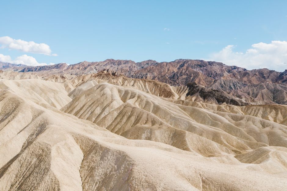
Death Valley National Park is the hottest, driest and lowest national park in the United States: more than 3.4 million acres of salt flats, sand dunes, colorful badlands and snow-capped peaks on the border of California and Nevada, about two hours from Las Vegas. At Badwater Basin you stand 282 ft (86 m) below sea level, while Telescope Peak rises to 11,049 ft (3,368 m) above it, and Furnace Creek holds the world’s highest recorded air temperature, 134 °F (57 °C) in July 1913. From November to March the park is a wonderful place to hike and drive; in summer the heat can kill, and the park asks visitors to stay on paved roads and off low-elevation trails after 10 a.m. In October 2026 the park is open, but Scotty’s Castle and Titus Canyon remain closed after flood damage.
Right now in Death Valley National Park (Furnace Creek)
- Wed26–39°C79–102°FClear
- Thu26–39°C79–103°FClear
- Fri27–37°C81–98°FClear
- Mon 12 Oct Columbus Day
- Mon 12 Oct Indigenous Peoples' Day · regional holiday in California
Top tours in Death Valley National Park
See all tours for Death Valley National Park →
From local operators, with prices and reviews; you check availability and book on Viator, our partner. We may earn a commission at no extra cost to you. How we earn money
Death Valley at a glance
- Best months: November to March, with highs of 66–83 °F (19–28 °C). Spring brings wildflowers after a wet winter; summer highs average 111–117 °F (44–47 °C).
- Time needed: one long day from Las Vegas for the Furnace Creek highlights; two or three days to add the dunes, Ubehebe Crater, Dantes View and a sunrise.
- Getting there: about 120 miles (193 km), roughly 2 hours, from Las Vegas via Pahrump, according to the park. There is no public transportation.
- Fees (as of October 2026): $30 per car for 7 days, card only. The $100 non-resident fee charged at 11 other national parks does not apply here. No reservation is needed to enter.
- Before you go: entry rules for international visitors, driving and tipping are in our United States travel guide.
What’s open and closed in October 2026
The park is open 24 hours a day, all year, and the main paved roads, Badwater Road to Badwater Basin and Artists Drive were open when the park last updated its road report on September 28, 2026. Floods in 2022 and 2023 (including 2.2 inches of rain from the remnants of Hurricane Hilary on August 20, 2023) did huge damage, and repairs continue:
- Scotty’s Castle and Bonnie Clare Road: closed for flood recovery work, with no access even on foot and no reopening date. The castle area can be visited only on occasional ticketed tours booked in advance.
- Titus Canyon Road: the one-way scenic section closed on October 2, 2026, for repairs expected to last until about May 2027. The short two-way section from the North Highway to the Fall Canyon trailhead closes from October 27, 2026, through December.
- Darwin Falls: the access road is washed out and likely to stay closed until summer 2027; you can park on the shoulder of Highway 190 and walk in.
- Lower Wildrose Road, from Trona, reopened on June 2, 2026, after nearly three years; vehicles over 25 ft (7.6 m) are not allowed.
- Campgrounds: Emigrant Campground is closed indefinitely for water repairs. Texas Springs, Sunset and Stovepipe Wells campgrounds reopen for the cool season in the fall.
- Construction: a three-year, $69.5 million rebuild of the water and sewer systems at Furnace Creek and Cow Creek began in fall 2026; expect some reduced parking and short water outages.
Several gravel roads have loose surfaces, washouts or missing shoulders. Check the park’s road conditions page on the day you travel.
Entrance fees and passes (as of October 2026)
You buy your Death Valley pass online on Recreation.gov or at a self-service machine (card only) at the Furnace Creek Visitor Center, Stovepipe Wells Ranger Station, Zabriskie Point, Badwater Basin, Hell’s Gate and other pay points, and display it on your dashboard. The park does not accept cash.
| Pass | Price | What it covers |
|---|---|---|
| Private vehicle | $30 | One car and its passengers, 7 days; open to all visitors, including non-US residents |
| Motorcycle | $25 | Up to 2 motorcycles, 7 days |
| Per person (foot or bike) | $15 | Each person 16 or over; under-16s free |
| Death Valley annual pass | $55 | This park, 12 months; US citizens and residents |
| America the Beautiful pass | $80 residents / $250 non-residents | All national parks and federal lands for 12 months |
For international visitors: the $100-per-person non-resident fee introduced in 2026 applies only at 11 of the busiest parks, including Yosemite, Sequoia and Kings Canyon and the Grand Canyon, and not at Death Valley, so the regular $30 car pass is fine here. If your road trip also includes Yosemite, Sequoia or the Grand Canyon, the $250 non-resident America the Beautiful pass covers all of them and waives the $100 fee at those parks. US residents enter free on the remaining 2026 fee-free days, October 27 and November 11; since 2026 these free days are for US residents only.
Top things to see in Death Valley
Badwater Basin
About 17 miles (27 km), or 30 minutes, south of Furnace Creek, Badwater Basin is the lowest point in North America, 282 ft (86 m) below sea level, with nearly 200 square miles (518 km²) of salt flats. Look for the sea-level sign high on the cliff above the parking lot, then walk out onto the white salt: about 1 mile (1.6 km) round trip to the edge of the crust, or 1.5–2 miles (2.4–3.2 km) to reach the hexagonal salt polygons. In summer the park advises no walking here after 10 a.m.
Zabriskie Point and Golden Canyon
Just off Highway 190, Zabriskie Point looks over golden, wrinkled badlands to the salt flats and the Panamint Range; it is the classic sunrise spot. Below it, the Golden Canyon trail climbs between yellow walls to Red Cathedral: 3 miles (4.8 km) round trip with 577 ft (176 m) of climbing, about 1.5–2 hours. The Gower Gulch loop, 4.3 miles (6.9 km), returns through the badlands.
Artists Drive and Devils Golf Course
Artists Drive is a one-way scenic loop that begins 8.5 miles (13.7 km) south of the Highway 190 junction on Badwater Road; allow about 30 minutes. Halfway along, Artists Palette shows pink, green and purple volcanic hills, best in the late-afternoon light. Vehicles over 25 ft (7.6 m) are not allowed. Nearby, Devils Golf Course is a field of jagged salt pinnacles.
Dantes View
A 45-minute drive from Furnace Creek, this viewpoint sits 5,575 ft (1,699 m) above Badwater Basin, looking straight down onto the salt flats with Telescope Peak opposite. It is several degrees cooler than the valley floor and beautiful at sunset.
Mesquite Flat Sand Dunes
Near Stovepipe Wells, 24 miles (39 km) or 30 minutes west of Furnace Creek, these are the park’s most visited dunes. There is no trail: walk out about 2 miles (3.2 km) round trip to the tallest dune, 185 ft (56 m) high, ideally at sunrise or sunset when the ripples cast long shadows. Do not hike here after 10 a.m. in summer.
Ubehebe Crater
In the north of the park, about an hour’s drive from Furnace Creek, this volcanic crater is about half a mile (0.8 km) wide and 500–777 ft (150–237 m) deep, formed by a steam explosion roughly 2,100 years ago. A 1.5-mile (2.4 km) loop follows the rim; the path down into the crater is easy going down and hard coming back up.
Harmony Borax Works and Salt Creek
Short, easy stops north of Furnace Creek: the ruins of the 1880s borax works, home of the famous twenty-mule teams (a 0.4-mile / 0.6 km walk), and the Salt Creek boardwalk (0.5 mile / 0.8 km), where tiny pupfish swim in the stream from about November to May.
Nature
- Golden Canyon
Archaeological sites
- Harmony Borax Works
Viewpoints
- Dante's View
- Zabriskie Point
Other sights
- Badwater Basin
- Mesquite Flat Sand Dunes
Peaks and mountains
- Ubehebe Crater
Hiking and heat safety
The best hiking season is November to March. In summer the park does not recommend hiking at low elevations at all, and warns that even days in the 80s and 90s °F (27–37 °C) can be deadly. Its rules of thumb:
- Drink at least a gallon (4 liters) of water per person per day, and carry extra in the car. Water is available at Furnace Creek, Stovepipe Wells and Panamint Springs.
- No hiking after 10 a.m. in summer at Badwater Basin, the dunes, Ubehebe Crater and other low trails; hike only in the early morning or in the mountains.
- Stay on paved roads in summer. Backcountry travel from April to mid-October is dangerous; there is no cell service on most roads, and GPS directions can send you onto impassable tracks. If your car breaks down, stay with it.
- Drive carefully: according to the park, most deaths in Death Valley are caused by single-vehicle rollovers. On long, steep grades such as Towne Pass, use low gears to save your brakes.
- Flash floods: stay out of canyons when rain threatens, and never drive through flooded dips. Do not enter old mines.
The dangers are real: on August 17, 2026, a 68-year-old visitor from France died after his car became stuck in mud on the unpaved West Side Road in 116 °F (47 °C) heat. Good cool-season hikes include Golden Canyon, Mosaic Canyon (4 miles / 6.4 km round trip), Natural Bridge (1 mile / 1.6 km) and, for fit hikers when it is free of snow, Telescope Peak (12.2 miles / 19.6 km round trip, about 7 hours, 3,375 ft / 1,029 m of climbing). See our hiking guide.
Stargazing and the Racetrack
Death Valley is an International Dark Sky Park at the highest (Gold Tier) level, and on a moonless night the Milky Way stretches across the sky; Harmony Borax Works, Badwater and the dunes are good spots. The remote Racetrack, famous for rocks that leave long trails across a dry lakebed, is at least 3.5 hours each way from Furnace Creek on a rough road where, the park says, high clearance, good tires and usually four-wheel drive are needed; standard rental cars are not recommended and often get flat tires.
Getting there
You need a car: there is no public transportation to or inside the park. Fill up before you arrive; gas inside the park is expensive but available at Furnace Creek and Stovepipe Wells 24 hours a day and at Panamint Springs from 7 a.m. to 9:30 p.m. Stovepipe Wells sells regular gasoline only, with no diesel. There are no fast electric-vehicle chargers in the park; the nearest are in Beatty, Nevada, 43 miles (69 km) from Furnace Creek.
| From | Route | Distance and time to Furnace Creek |
|---|---|---|
| Las Vegas, NV | NV 160 to Pahrump, then CA 127 and CA 190 | About 120 miles (193 km), 2 hours |
| Beatty, NV | NV 374 via Daylight Pass | About 45 minutes |
| Lone Pine, CA | CA 136 and CA 190 from US 395 | About 1 hour 45 minutes |
| Los Angeles, CA | CA 14 and US 395, or Interstate 15 and CA 127 | Roughly 270–290 miles (435–465 km), 4.5–5 hours |
From Las Vegas, many tour companies run long day trips; see our Las Vegas travel guide. From the west, the drive from Los Angeles passes through the Mojave Desert and can be combined with Lone Pine and the Eastern Sierra.
Around Death Valley
- Rhyolite and Beatty: a gold-rush ghost town and open-air sculpture garden just outside the park in Nevada.
- Lone Pine and Mount Whitney: the Alabama Hills, film-set rocks below the highest peak in the lower 48 states, about 1 hour 45 minutes west.
- Shoshone and Tecopa: small desert villages with hot springs and a date farm on the southern approach.
- Further afield: Joshua Tree National Park is about four hours south, and Sequoia National Park is about five hours west over the Sierra Nevada.
Nearby destinations
- Las Vegas156 km
- Sequoia National Park172 km
- Yosemite National Park278 km
- Palm Springs294 km
- Los Angeles295 km
When to go and how long to stay
Death Valley is extremely dry and sunny, with mild winters and some of the hottest summers on Earth. According to the park, summer days often top 120 °F (49 °C) in the shade, with overnight lows in the 90s °F (32–37 °C). Temperatures drop by about 3–5 °F for every 1,000 ft you climb (roughly 2–3 °C per 300 m), so the mountains are much cooler. The table uses NOAA’s 1991–2020 normals for the Death Valley station at Furnace Creek, 194 ft (59 m) below sea level.
| Season | Average high / low at Furnace Creek | What it’s like |
|---|---|---|
| Winter (Dec–Feb) | 66–74 °F (19–23 °C) / 41–49 °F (5–9 °C) | Sunny and mild; cold nights, snow on the peaks; busiest around the holidays. |
| Spring (Mar–May) | 83–101 °F (28–38 °C) / 57–75 °F (14–24 °C) | Wildflowers after wet winters, windstorms and dust; very busy in March and April. |
| Summer (Jun–Aug) | 111–117 °F (44–47 °C) / 84–91 °F (29–33 °C) | Dangerous heat; stay on paved roads; occasional thunderstorms and flash floods. |
| Fall (Sep–Nov) | 108 °F falling to 77 °F (42–25 °C) / 79 °F falling to 51 °F (26–10 °C) | Still hot in September and early October; lovely from late October. |
Furnace Creek gets only about 2.2 inches (56 mm) of rain a year. The park records include the world-record 134 °F (57 °C) on July 10, 1913, and 154 days in a row at or above 100 °F (38 °C) in 2001.
Weather month by month
Death Valley in one day
Arrive early for sunrise at Zabriskie Point, walk Golden Canyon, then drive south to Badwater Basin, Devils Golf Course and Artists Drive. Stop at the Furnace Creek Visitor Center (open daily 8 a.m.–5 p.m.), then head west to the Mesquite Flat dunes for sunset.
Two or three days
Add Dantes View, Mosaic Canyon and Ubehebe Crater, an evening of stargazing, and Harmony Borax Works and Salt Creek. With a high-clearance vehicle and the right conditions, consider a guided trip to the Racetrack. Leave via Rhyolite to Las Vegas or via Lone Pine to the Eastern Sierra.
Where to stay in Death Valley
- The Oasis at Death Valley, Furnace Creek: the historic Inn at Death Valley, a first-class resort, and the family-friendly Ranch at Death Valley, with restaurants and a general store.
- Stovepipe Wells Village: a motel, restaurant, saloon and RV sites near the dunes.
- Panamint Springs Resort: a small, rustic lodge and campground on the western edge.
- Outside the park: Beatty (about 45 minutes), Shoshone (1 hour), Pahrump (1.5 hours) and Lone Pine (1 hour 45 minutes) are cheaper.
- Camping: Furnace Creek Campground can be reserved on Recreation.gov from October 15 to April 15, up to six months ahead; other park campgrounds are first-come, first-served.
All three in-park hotels are open all year; book well ahead for winter weekends, holidays and the spring wildflower season. Room rates are quoted before tax; Inyo County’s code sets a 12% transient occupancy tax on lodging in its unincorporated area.
Practical tips for Death Valley
- Check road conditions and alerts on the park’s website before you set off; download offline maps, as there is no cell service in most of the park.
- Fuel and food: fill your tank and carry snacks; services are far apart.
- Time zone: the park uses Pacific time, the same as Las Vegas and Los Angeles.
- Sales tax: according to the state tax agency (CDTFA), Inyo County’s rate is 7.75% as of October 2026.
- Leave nothing behind: stay off the fragile salt crust when it is wet, and never drive off road.
- Emergencies: call 911 where there is signal; a satellite messenger is a good idea for remote roads.
What to pack for Death Valley
Bring far more water than you think you need (a gallon, or 4 liters, per person per day, plus spare in the car), salty snacks, a wide-brimmed hat, sunglasses, high-factor sunscreen and light, loose clothing. Sturdy shoes protect your feet from sharp salt and hot ground. In winter, add a warm jacket for cold nights and the high viewpoints, and bring a headlamp for stargazing.
Death Valley travel FAQ
How much does it cost to enter Death Valley in 2026?
$30 per car, $25 per motorcycle or $15 per person on foot or bike, valid for 7 days. The park is card-only and has no cash sales.
Do international visitors pay the $100 non-resident fee at Death Valley?
No. In 2026 that fee applies only at 11 busy parks, including Yosemite and Sequoia and Kings Canyon, but not Death Valley.
Do I need a reservation to visit Death Valley?
No reservation or timed entry is needed. Book lodging well ahead, and Furnace Creek Campground for the October 15 to April 15 season.
Is it safe to visit Death Valley in summer?
Only with great care. Stay on paved roads, do not hike at low elevations after 10 a.m., drink at least a gallon of water a day and stay with your car if it breaks down.
Is Scotty’s Castle open?
No. The castle and Bonnie Clare Road remain closed for flood recovery with no reopening date; access is only on occasional ticketed tours.
Is Titus Canyon Road open?
Not in fall 2026. The one-way section closed on October 2, 2026, for repairs expected to last until about May 2027.
How far is Death Valley from Las Vegas?
About 120 miles (193 km), roughly 2 hours by car to Furnace Creek via Pahrump.
What is the best time to visit Death Valley?
November to March, for mild days and the best hiking. Spring can bring wildflowers after a wet winter.
Is there gas in Death Valley?
Yes, at Furnace Creek and Stovepipe Wells (24 hours) and Panamint Springs, but it is expensive. Fill up before you enter.
Plan your trip
Partner links: TravelerCenter may earn a commission if you book, at no extra cost to you.
Sources · last reviewed 4 October 2026
Researched and last reviewed on 4 October 2026. Fees, passes, the non-resident fee list, fee-free days, road and campground conditions, closures, the Titus Canyon and Lower Wildrose news releases, the water project, heat and safety advice, the August 2026 fatality, sights, trails, lodging, gas, distances from Las Vegas and nearby towns, records and dark skies come from Death Valley National Park and the National Park Service; climate from NOAA’s 1991–2020 normals for Death Valley (Furnace Creek); sales tax from the California Department of Tax and Fee Administration. The Los Angeles drive time and Inyo County’s hotel tax come from secondary or summarized sources and are flagged for checking. Conditions change after storms, so check the park’s alerts before you travel. For entry rules, driving and tipping, see our United States travel guide.
Also: NOAA NCEI normals 1991–2020, Death Valley (Furnace Creek) (climate)
Data: Weather: MET Norway (CC BY 4.0) · Rates: ECB · Holidays: Nager.Date · Costs: World Bank ICP and price levels · © OpenStreetMap contributors (ODBL) · Wikidata (CC0)