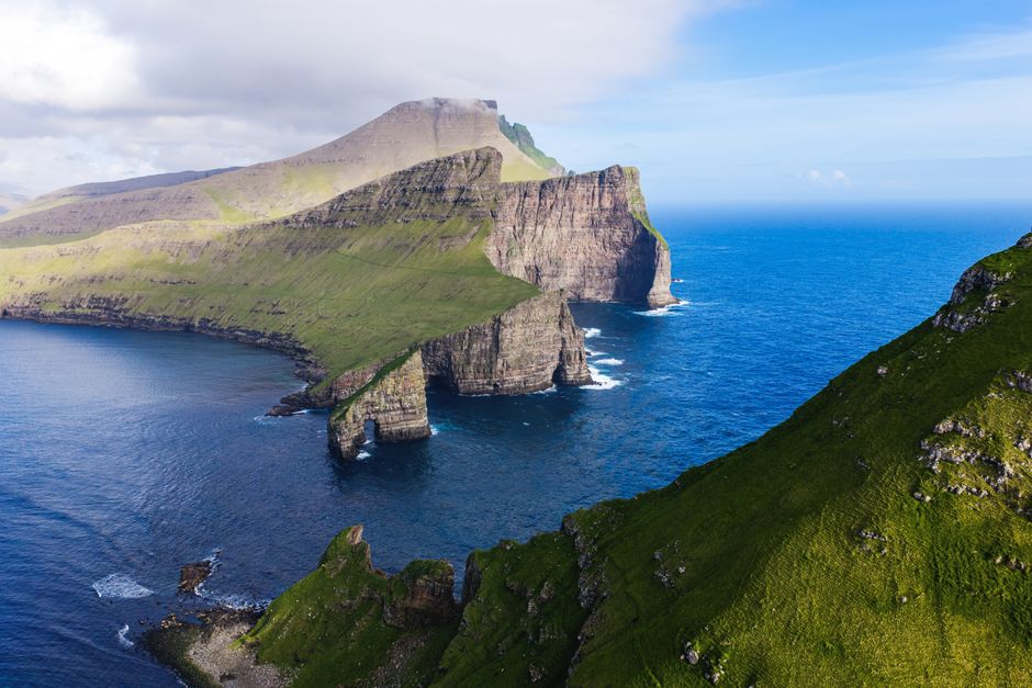
Vágar is the third-largest of the Faroe Islands and the one almost every visitor sees first: the islands’ only airport is here, and so are some of their most famous views. About 178 km² (69 square miles) of green mountains, lakes and cliffs, with a few thousand people in a handful of villages, Vágar packs in the Múlafossur waterfall pouring into the sea below the village of Gásadalur, Lake Sørvágsvatn, the “lake above the ocean,” seen from the cliff of Trælanípa, the sea stacks of Drangarnir and the needle-peaked islet of Tindhólmur. From the harbor at Sørvágur, a small ferry crosses to Mykines, the puffin island. A subsea tunnel links Vágar with Streymoy, so Tórshavn is about 45 minutes away by car. Come from May to August, when the Mykines ferry and guided hikes run, spend at least a full day here, and stay a night or two if you want to see the island at its quietest in the long summer evenings.
Right now in Vágar
- Wed3–9°C38–49°F1 mm rain
- Thu5–8°C42–46°F13 mm rain
- Fri7–10°C45–49°F9 mm rain
Top tours in Vágar
See all tours for Vágar →
From local operators, with prices and reviews; you check availability and book on Viator, our partner. We may earn a commission at no extra cost to you. How we earn money
Vágar at a glance
- Best for: waterfalls and sea cliffs, easy and guided hikes, puffins on Mykines, photography, and a first or last night near the airport.
- How long: one full day for Gásadalur, Trælanípa and Bøur; two or three days with Mykines and the Drangarnir hike, plus a spare day for weather.
- Best time: May to August; the Mykines ferry runs three times a day from 1 May to 31 August.
- Getting there: fly into Vágar Airport, or drive or take bus 300 from Tórshavn (about 50 minutes to the airport) through the Vágar tunnel.
- Getting around: a rental car is easiest; bus 300 links the airport, Sandavágur, Miðvágur and Sørvágur.
- Before you go: entry rules, money and the islands’ hiking fees are in our Faroe Islands travel guide.
Vágar’s villages and who each one suits
- Sørvágur: the village at the head of Sørvágsfjørður, next to the airport, with the harbor for the Mykines ferry and views of the islets of Tindhólmur and Gáshólmur. Best for Mykines day trips and early flights.
- Miðvágur: the largest village, with the local administration, a medical center, shops and the trailhead for Trælanípa. A practical base with places to stay and eat.
- Sandavágur: Miðvágur’s twin village to the east, closest to the tunnel to Streymoy, with a village church and a small harbor.
- Bøur: a tiny, old village about 5 km beyond Sørvágur, with turf-roofed houses and the classic view of Tindhólmur. For peace and photography.
- Gásadalur: a hamlet of a handful of residents above the sea, with the Múlafossur waterfall and a small café. A day stop rather than a base.
Top things to see on Vágar
Gásadalur and the Múlafossur waterfall
Múlafossur, the waterfall that drops straight off the cliffs into the sea below Gásadalur, is the most photographed sight in the Faroes. A short, easy path from the parking area in the village leads to the viewpoint; there is no fee. Until a road tunnel was built in 2004, Gásadalur was one of the most isolated villages in the islands, and Visit Faroe Islands recalls that the postman carried the mail over the mountain three times a week. The drive from the airport takes about 15 minutes. Stay behind the fences and on the path, and park only in the marked area, not in farm entrances.
Trælanípa and Lake Sørvágsvatn
Sørvágsvatn, also called Leitisvatn, is the largest lake in the Faroes. Seen from the cliff of Trælanípa at its southern end, a clever trick of perspective makes it look as if it is floating high above the Atlantic. The walk starts in Miðvágur and crosses private land: according to the landowners, it is about 3.5 km (2.2 miles) each way, roughly 45 minutes of easy walking in each direction, and most people take 2.5 to 3 hours with photo stops. When we checked in 2026, walking on your own cost 200 DKK per person, paid at the café at the trailhead (children up to 15 free); guided tours must be booked at least two days ahead and cost more. Near the end of the lake, the Bøsdalafossur waterfall spills from the lake into the sea. Stay well back from the cliff edges, which are unfenced and very high.
Drangarnir and Tindhólmur
Off the west coast, Tindhólmur rises sheer from the sea to 262 m (860 ft), with five sharp peaks, and nearby stand Drangarnir, two great sea stacks known as Stóri Drangur and Lítli Drangur. You can see Tindhólmur from Bøur and Sørvágur. Walking out to the viewpoint above Drangarnir is only allowed with a guide, as the land is private and Visit Faroe Islands warns that hiking there without one can be fined. Guided hikes of about five hours run on set days from April to October and cost 600 DKK per person, booked through hiking.fo. Boat trips from Sørvágur also sail out to the stacks in summer.
Mykines
The westernmost Faroe island is a world of puffins, gannets and grassy cliffs, with a tiny village by the landing. SSL’s ferry from Sørvágur takes about 45 minutes; from 1 May to 31 August, it leaves Sørvágur at 09:30, 13:30 and 17:30, and the adult fare was 153 DKK (123 DKK online) when we checked, not covered by the tourist travel card. In the same period, Visit Faroe Islands says anyone going beyond the village must hike with a guide and pay 500 DKK (400 DKK online) for ages 15 and over, and the path out to the lighthouse on Mykineshólmur was closed. Outside the summer season, sailings are few. Ferries often sell out and are cancelled in heavy seas, so book ahead and keep a spare day; stepping on and off the boat can involve a small jump.
Bøur
Visit Faroe Islands describes Bøur, about 5 km west of Sørvágur, as an old and scenic village of only 71 inhabitants. Its black and white houses with grass roofs face Tindhólmur across the water, especially beautiful in the evening light. It is a lovely stop on the road to Gásadalur.
Vágar Airport and its wartime past
The airport began as a military airfield built by British forces during World War II. Landing here is an experience in itself, between mountains and fjords. Atlantic Airways also offers helicopter sightseeing over Vágar in season.
Hiking, birds and boats on Vágar
Vágar has walks for every level, from the five-minute stroll to Múlafossur to the Trælanípa walk and the long guided Drangarnir hike. The island’s highest point, Árnafjall, reaches 722 m (2,369 ft). Many routes cross private land, where walking needs the owner’s permission, so follow the signs and pay fees where they are asked. Fog can come in fast, the grass is slippery after rain and many cliff edges overhang the sea: keep well back from the edge and check the weather before you set out. See our hiking guide.
From late spring to August, the cliffs are alive with seabirds: puffins on Mykines, gannets on Mykineshólmur, and fulmars and kittiwakes along the coast. Boat trips from Sørvágur sail to Drangarnir and Tindhólmur and along the cliffs in summer, weather permitting. See our boat trips guide.
Getting there and getting around
By air
Vágar Airport is the gateway to the Faroes, served by Atlantic Airways daily from Copenhagen and year-round from Billund and Reykjavík, with other European routes, many of them seasonal; see our Faroe Islands guide. Rental cars, taxis and bus 300 are at the terminal, and the airport information desk sells SIM cards and the SSL tourist travel card. Visitors can collect tax-free refunds here on departure.
From Tórshavn
Vágar is linked to Streymoy by the Vágatunnilin subsea tunnel, opened in 2002 and 4.9 km (3 miles) long. According to tunnil.fo, the toll for a car is 50 DKK, charged when you leave Vágar and covering both directions; with a Faroese rental car you pay through the rental company. SSL’s bus 300 runs from the Tórshavn terminal via Sandavágur and Miðvágur to the airport (about 50 minutes) and Sørvágur; bus 350 also serves the airport.
Getting around the island
A car is the easiest way to combine Gásadalur, Bøur and the trailheads in a day; distances are short, and the drive from the airport to Gásadalur takes about 15 minutes. Headlights must be on at all times, the speed limit is 80 km/h outside villages and 50 km/h in them, and sheep often wander onto the road. Without a car, use bus 300 between the villages and check SSL’s timetable for connections farther out.
When to go and how long to stay
Vágar shares the Faroes’ cool, wet maritime climate. The Danish Meteorological Institute’s 1991–2020 normals for Tórshavn, the islands’ reference station, show average afternoon highs of 11.3–13.3 °C (52–56 °F) from June to August and about 6 °C (43 °F) in winter, with rain or drizzle on most days of the year; the west coast is often windy, and fog can hide the cliffs for hours. May to August is the season for the Mykines ferry, guided hikes and seabirds. In winter, Gásadalur and Trælanípa are still reachable on clear days, but days are short and paths can be icy or muddy.
Spend a full day on Vágar for Gásadalur, Trælanípa and Bøur, add a day for Mykines and another for Drangarnir, and keep a spare day in case the ferry is cancelled. Staying on the island also makes sense on your first or last night, close to the airport.
Where to stay on Vágar
- Sørvágur and the airport: a hotel and guesthouses minutes from the terminal and the Mykines ferry. Best for early flights and Mykines trips.
- Miðvágur and Sandavágur: guesthouses, apartments and holiday homes in the island’s main villages, close to shops and the Trælanípa trailhead.
- Bøur and Gásadalur: a few holiday homes and a guesthouse in the quietest corners, for photographers who want sunset and sunrise light.
Beds are limited, so book well ahead for May to August. Many visitors stay in Tórshavn instead and come to Vágar on day trips.
What a trip to Vágar costs
Vágar’s prices match the rest of the Faroes, which means expensive. The views at Múlafossur and Bøur are free, but plan for hiking fees: 200 DKK for Trælanípa on your own, 600 DKK for the guided Drangarnir hike, and 500 DKK (400 DKK online) plus the ferry for Mykines. Our estimates for one person per day, sharing a double room, as of October 2026:
| Style | Estimated cost per day | What that looks like |
|---|---|---|
| Budget | about 700–1,100 DKK (US$110–170) | A guesthouse room, buses with a travel card, supermarket food, the free viewpoints and one paid hike |
| Mid-range | about 1,500–2,500 DKK (US$230–390) | A hotel or apartment, a shared rental car, Mykines or Drangarnir with a guide, restaurant dinners |
| High-end | about 3,500 DKK+ (US$540+) | The best rooms, private guides, boat trips and a helicopter sightseeing flight |
Practical tips for Vágar
- Book Mykines early: ferries and guided hikes sell out in June and July; book online for the lower prices.
- Respect private land: pay fees where asked, close gates, stay on paths and never walk to Drangarnir without a guide.
- Keep a spare day: wind and waves cancel ferries and fog hides the views; plan flexible days around your Mykines trip.
- Tunnel toll: 50 DKK by car when you leave Vágar, covering the return trip; with a rental car, the rental company charges you.
- Emergencies: dial 112; Miðvágur has a medical center, and the after-hours medical line is 1870.
What to pack for Vágar
Pack a fully waterproof jacket and trousers, warm layers, a hat and gloves even in summer, sturdy waterproof hiking boots with good grip for wet grass, and a dry bag for the Mykines ferry. Bring binoculars for the seabirds and a two-pin European plug adapter if you are coming from North America or the UK.
Vágar travel FAQ
Is there a fee to see the Múlafossur waterfall?
No. The viewpoint above Gásadalur is a short, free walk from the village parking area. Park only in the marked area.
How much does the Trælanípa hike cost?
When we checked in 2026, 200 DKK per person to walk on your own, paid at the café at the trailhead in Miðvágur, with children up to 15 free. Guided tours cost more and must be booked two days ahead.
How long is the Trælanípa hike?
About 3.5 km (2.2 miles) each way on fairly easy ground, roughly 45 minutes in each direction; allow 2.5 to 3 hours with stops.
How do I get to Mykines?
By SSL ferry from Sørvágur, about 45 minutes; from 1 May to 31 August, it sails three times a day. In that period, going beyond the village requires a guided hike (500 DKK, or 400 DKK online, for ages 15 and over). Book ahead and keep a spare day for weather.
Can I hike to Drangarnir on my own?
No. The land is private, and walking there is only allowed with a guide; guided hikes cost 600 DKK per person and run on set days from April to October. You can see the stacks from boat trips too.
How far is Vágar Airport from Tórshavn?
About 45 minutes by car or 50 minutes on SSL bus 300, through the Vágar subsea tunnel.
Is it worth staying on Vágar?
Yes, for a night or two if you plan to visit Mykines, catch an early flight or photograph Gásadalur and Bøur in the evening light. Otherwise, Vágar is an easy day trip from Tórshavn.
Plan your trip
Partner links: TravelerCenter may earn a commission if you book, at no extra cost to you.
Sources · last reviewed 6 October 2026
Researched and last reviewed on 6 October 2026. Gásadalur, Múlafossur, Bøur, Tindhólmur and Drangarnir details and the hiking fees for Mykines and Drangarnir come from Visit Faroe Islands; the Trælanípa route, fee and rules from the landowners (tralanipan.fo); the Mykines ferry timetable and fares, bus 300 and the tourist travel card from Strandfaraskip Landsins (SSL); the Vágar tunnel toll, length and opening year from tunnil.fo; flights from Atlantic Airways; the island’s area and highest point from Wikidata; and climate normals from the Danish Meteorological Institute (DMI, Tórshavn, 1991–2020). The airport’s wartime history and the lake’s size come from general sources and are flagged for checking; daily costs are our estimates. Prices, timetables and access rules change, so check the official sites before you travel.
Data: Weather: MET Norway (CC BY 4.0) · Sea temperature: NOAA CoastWatch · Rates: ECB · Wikidata (CC0)