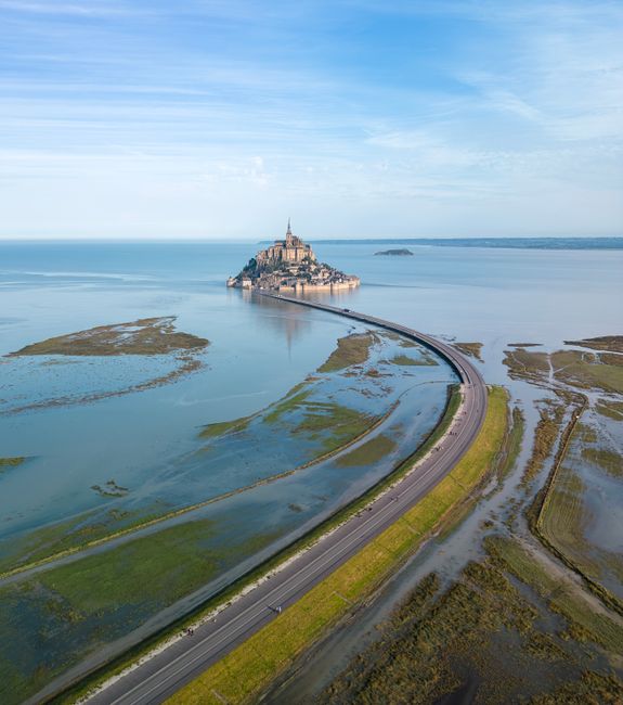
Mont-Saint-Michel is a granite island crowned by a medieval abbey, rising out of a vast tidal bay on the border of Normandy and Brittany. You come to climb the village’s single steep street to the abbey, walk the ramparts above miles of sand, watch the tide race in, and, with a certified guide, cross the bay barefoot as pilgrims did. The village is free to enter at any hour; only the abbey and the car park are paid. Give it a long day, and stay a night nearby to see it lit up and without the crowds.
Right now in Mont-Saint-Michel
- Wed14–17°C58–62°F13 mm rain
- Thu11–15°C53–59°FMostly clear
- Fri11–17°C51–63°F2 mm rain
Top tours in Mont-Saint-Michel
See all tours for Mont-Saint-Michel →
From local operators, with prices and reviews; you check availability and book on Viator, our partner. We may earn a commission at no extra cost to you. How we earn money
Mont-Saint-Michel at a glance
- Best for: the abbey, medieval lanes and ramparts, huge tides, guided walks across the bay and sunset views.
- How long: half a day for the village and abbey, a full day with a bay walk, one night to enjoy the evening and early morning.
- Best time: April–June and September–October; early morning or late afternoon on any day. Check the tide timetable before you go.
- Getting in: car parks on the mainland, 2.5 km from the rock, then the free “Le Passeur” shuttle or a 45-minute walk; buses from Pontorson station, Rennes and Saint-Malo.
- Tickets: the village is free; the abbey costs €13 from 1 October 2026 (€16 from April to September), free for under-18s.
- Before you go: entry rules, money and general safety are in our France travel guide; the wider region is in our Normandy guide.
The Mont, the bay and the mainland
The Mont and its bay have been on UNESCO’s World Heritage list since 1979, among the first sites ever inscribed. A causeway once led straight to the walls, but it silted up the bay. Since 2015 a light bridge-walkway of 2.2 km links the mainland to the rock, and a dam on the Couesnon river flushes the sand away, so on the biggest tides the Mont becomes an island again. Think of a visit in three parts.
The rock: abbey, village and ramparts
Inside the King’s Gate, the Grande Rue climbs steeply past half-timbered houses, restaurants, souvenir shops and small museums to the parish church of Saint-Pierre and the abbey stairs. Only a few dozen people live here year-round, but millions visit each year. The ramparts give the best views over the bay. Best for: everyone, ideally early or late in the day.
The bay
Around the Mont lie vast sand flats, salt meadows where sheep graze, river channels and quicksand, with the islet of Tombelaine to the north. The sea goes out several kilometres at low tide and comes back fast. Best for: guided walks, birdwatching and photography; never on your own.
The mainland: La Caserne and Beauvoir
All the car parks, the visitor information centre, the shuttle stop, hotels, restaurants and supermarkets are on the mainland, around La Caserne, 2.5 km south of the rock, with Beauvoir and Pontorson further inland. Best for: sleeping, parking and cheaper meals.
Top things to see at Mont-Saint-Michel
Prices and hours below were checked on the official sites in October 2026. They change, so check before you go.
The abbey
Built over a thousand years on top of the rock, the abbey is a stack of churches, crypts, halls and cloisters. Highlights are the abbey church at the summit, the open West Terrace with its view over the bay, the “Merveille” (the Marvel), a three-storey Gothic monastery on the north side, and its cloister seemingly hanging in the sky. Run by the Centre des monuments nationaux (CMN), it opens daily 9:30–18:00 from September to April and 9:00–19:00 from May to August, with last entry one hour before closing. It closes on 1 January, 1 May and 25 December.
An individual ticket costs €16 from 1 April to 30 September 2026 and €13 from 1 October 2026 to 31 March 2027. Entry is free for under-18s (with their families), for EU citizens and regular residents of France aged 18–25, for visitors with a disability card and one companion, and for everyone on the first Sunday of January, February, March, November and December. A “Revelacio” tablet guide costs €6. Book a timed ticket on the official CMN ticket site, especially in summer; there is also a ticket office on site. Minors must be accompanied by an adult, and pets are not allowed. In July and August the abbey hosts evening openings with a light and art trail (3 July–31 August in 2026).
The Grande Rue and the village
The village is a commune with no gate fee and no closing time. The narrow main street gets very crowded from late morning to mid-afternoon in summer. Escape up side stairs to the ramparts, peek into the little churchyard of Saint-Pierre, and look for the famous puffy omelettes cooked over a wood fire. Public toilets inside the walls cost €1; free ones are at the information centre.
The ramparts
Free to walk, the 15th-century walls run along the east side of the rock with towers and lookout points. From here you watch the tide come in and the bay change colour. The walk links up with the Grande Rue, so you can climb by one route and come down by the other.
The bridge-walkway and the dam
The walk across the 2.2 km bridge is one of the best parts of the visit, with the Mont growing ahead of you. At the dam on the Couesnon, a terrace looks over the water releases, when the river rises by about 40 cm and rushes out to scour the sand. The official site publishes the release times each day.
The view from the shore
Some of the best views of the Mont are from outside it: from the bridge at dusk, from the salt meadows along the Couesnon, and from Genêts and the Bec d’Andaine across the bay, where the bay walks start. In the evening the abbey is floodlit, and the crowds have gone.
- Mont-Saint-Michel Abbey
- Church of Saint-Pierre (Mont-Saint-Michel)
- Maison de l'Artichaut
- Saint-Aubert Chapel
- Saint-Aubert Fountain
- Villa Bellevue (Le Mont-Saint-Michel)
Tides at Mont-Saint-Michel
The bay has some of the biggest tidal ranges in Europe: on the official tide table for the first days of October 2026, high and low water differ by more than five metres even on a modest tide. Tides come twice a day, about 50 minutes later each day, and their strength is measured by a coefficient from 20 to 120.
Where to find the tide timetable
Use the official sources. The Établissement public du Mont-Saint-Michel shows the day’s tide times, heights and coefficient on its “Météo & marées” page, publishes the Couesnon dam release times for today and tomorrow, and offers a downloadable calendar of all 2026 tides. The French Navy’s hydrographic office (SHOM) publishes official tide predictions for the area too. Local tourist offices hand out printed tide tables.
When the Mont becomes an island
On the very biggest tides, around the spring and autumn equinoxes and certain full and new moons, the sea surrounds the Mont and covers the end of the bridge-walkway for about an hour. The official site advises arriving one to two hours before high tide to watch the water rise and the tidal bore race up the bay, and getting onto the rock before it is surrounded. Once cut off, allow one to one and a half hours before the walkway opens again. In 2026 the public institution listed only two of these big island tides, on 14 August and 12 September, both evening high tides; check its calendar for 2027 dates as they are announced. On ordinary days the walkway stays open at all times.
Tides and safety
The tide comes in quickly over very flat sand, rivers change course, and there is quicksand. The bicycle park at the foot of the ramparts can flood on big tides. Never walk out onto the sand alone, even at low tide, and leave the beach below the walls when the water starts to rise.
Crossing the bay with a guide
Walking across the sands to the Mont is a wonderful experience, and the guidance is clear: never cross the bay alone. Fast tides, river channels, quicksand and the daily dam releases make it dangerous without someone who knows the day’s conditions. Go with a “guide attesté”, a professional guide holding the certificate of competence required by the Manche prefecture for anyone leading groups across the bay. Certified guides wear a specific orange-and-white vest on their backpack and carry a guide card; ask to see it if you are unsure.
- Where they start: mainly the Bec d’Andaine at Genêts, across the bay to the north, and the Mont itself, with other starts depending on the tides.
- How long: the tourist office lists short quicksand discovery walks of 1½–2 hours, the Mont to Tombelaine islet in about 3 hours, and the classic crossing of about 13 km in 5 hours or more.
- What to wear: barefoot or close-fitting neoprene booties (no other shoes), shorts, and layers including a windproof and a fleece. Bring water, sunscreen and a small bag; there are no facilities on the sand.
- How to book: all crossings and themed walks (big-tide outings, night crossings, birdwatching) are listed for booking on the Mont-Saint-Michel–Normandie tourist office site. You need reasonable fitness.
From spring to summer the public institution also runs its own guided nature walks around the bay. More walking ideas are in our hiking guide.
Things to do around the Mont
Walk or cycle the bay paths
The official site counts more than 40 waymarked trails around the bay. Several long-distance paths (GR 21, 22, 223 and 34) and the pilgrim routes of the Chemins de Saint-Michel end at the Mont. The bridge-walkway is open to bikes 24 hours a day, except during exceptional prefectural orders, and four long-distance cycle routes pass through, including the Véloscénie from Paris and the Vélomaritime and EuroVelo 4 along the coast. Cyclists must use the west side of the bridge and dismount when it is crowded. See our cycling guide.
Eat salt-meadow lamb and the famous omelette
Sheep graze on the salt meadows around the bay, and their lamb (agneau de pré-salé) is the local speciality. The big fluffy omelettes cooked over a wood fire on the Mont are famous and expensive; the mainland and nearby villages offer better value. For oysters, head to Cancale on the Breton side.
See it at night
The shuttle runs late, the car parks are free in the evening for most of the year, and the floodlit Mont seen from the bridge is unforgettable. In July and August, the abbey’s evening openings let you explore the halls after dark.
Activities and best months
- HikingWalks across the bay must be made with a guide certified by the prefecture (44 are listed): from a 1.5-2 hour quicksand walk and a trip to the islet of Tombelaine to a 13 km round-trip crossing from Genêts (Bec d'Andaine) or Grouin du Sud.
Day trips from Mont-Saint-Michel
Saint-Malo and Cancale
Across the Breton border, Saint-Malo is a walled corsair city by the sea, with ramparts to walk and tidal islands to reach at low tide. Cancale, on the way, is the oyster capital of the bay, with stalls selling them by the dozen on the harbour. Keolis Armor coaches link Saint-Malo with the Mont in about an hour on some days.
Avranches and the Scriptorial
On the hill facing the Mont, Avranches keeps the abbey’s medieval manuscripts in the Scriptorial museum, and its gardens have a classic view across the bay. Show your Scriptorial ticket at the abbey for a reduced entry.
Granville and the Normandy coast
North along the coast, Granville is a fortified port with beaches, the Christian Dior villa and boats to the Chausey islands. Further on, the D-Day beaches, Bayeux and the rest of Normandy are about two hours by car.
Nearby destinations
- Saint-Malo38 km
- Normandy95 km
- Brittany131 km
- Nantes158 km
- Loire Valley197 km
- Jurassic Coast254 km
- Brighton262 km
- Île de Ré271 km
Getting to Mont-Saint-Michel
By car. From Paris, take the A13 to Caen, then the A84 towards Rennes (about 337 km), or the A11 and A81 via Le Mans. All cars must use the paid car parks on the mainland, 2.5 km from the rock; you cannot drive to the Mont. Follow the signs to the parking areas and pay at the machines on the way out.
By train from Paris. The official site lists several options. The fastest is a TGV from Paris-Montparnasse to Rennes (about 1 hour 30 minutes on the fastest trains), then the Keolis Armor coach from Rennes to the Mont (about 1 hour 15 minutes, several a day, every day). There is also a direct regional “Mont-Saint-Michel train” from Paris to Pontorson at weekends all year and daily in summer, a TGV to Dol-de-Bretagne with buses on, and Nomad trains towards Granville or Caen with connections.
From Pontorson station. Pontorson, 9 km away, is the nearest station. Bus line 2 runs daily to the Mont in about 27 minutes, stopping at Le Verger, 350 m from the village entrance. Bus 308 links Granville and Avranches with the car parks, daily from 1 May to 30 September and at weekends the rest of the year.
By air. Rennes airport is the closest larger airport; Dinard has a few flights, and Paris airports are about four hours away by train and coach.
Parking and the Le Passeur shuttle
Car park fees (2026). Prices depend on the season and how long you stay. For a car, as of October 2026:
| Period | Up to 3 hours | Up to 6 hours | Up to 24 hours | Evening 18:30–03:00 |
|---|---|---|---|---|
| Low season: 1 Jan–28 Feb and 2 Nov–31 Dec | €10 | €12 | €14 | Free |
| Mid season: 1 Mar–30 Jun and 1 Sep–1 Nov | €16 | €19 | €22 | Free |
| High season: 1 Jul–31 Aug | €20 | €24 | €28 | €15 |
The first 30 minutes are free all year, bicycles park free, and motorhomes and motorcycles have their own rates. Booking online saves €2 a day (in mid and high season, for arrivals before 10:00 or after 15:00). A lost ticket is charged at the 24-hour rate. Car parks are run by Keolis Mont-Saint-Michel for the public institution.
Le Passeur shuttle. Free for everyone, it leaves from the shuttle square in front of the visitor information centre every 5 to 12 minutes and drops you near the foot of the rock. As of October 2026 it runs 8:30–22:00 in low season (November to February outside school holidays), 7:30–23:00 in March and October and from April to September, and 7:00–1:00 in July and August. Only animals in closed bags and assistance dogs are allowed on board. Walking takes about 45 minutes from the shuttle square to the Mont, and is the best way to arrive.
Visitor information centre (CIT). Next to the car parks and shuttle stop, open daily except 25 December and 1 January: 9:00–19:00 from April to September and 10:00–18:00 from October to March. It sells abbey tickets, has free toilets, a baby room and lockers for bags and pushchairs at €2, and a kennel for dogs at €8.60 a day.
When to go and how long to stay
The bay has a mild, breezy maritime climate with rain spread through the year. There is no official weather station on the Mont, so the table uses Météo-France’s 1991–2020 normals for Dinard, the nearest comparable coastal station, about 50 km to the west.
| Season | Average high / low | Rainy days per month | What it’s like |
|---|---|---|---|
| Spring (Mar–May) | 12–17 °C / 5–9 °C | 9–10 | Fresh and bright, fewer crowds; equinox tides in March |
| Summer (Jun–Aug) | 20–22 °C / 12–14 °C | 8–9 | Mild and long evenings; busiest, crowded at midday; evening abbey openings |
| Autumn (Sep–Nov) | 20 °C falling to 12 °C / 12 °C falling to 7 °C | 9 in September, 13–14 in October–November | Lovely September light, big tides; wetter and windier later |
| Winter (Dec–Feb) | 9–10 °C / 4 °C | 11–14 | Cool, grey and windy, but quiet and atmospheric; cheapest parking |
Dinard averages about 750 mm of rain a year, with the wettest months from October to December. Wind can make the bay feel colder than the thermometer says, so bring a layer in any season.
Beat the crowds
Most coach groups arrive between late morning and mid-afternoon. Arrive by 9:00 and go straight up to the abbey, or come after 16:00 and stay for sunset. Weekdays outside school holidays are calmest. In summer and around holiday weekends, book the abbey and, if you can, the car park ahead.
A day or a night?
A day trip works: walk across in the morning, visit the abbey, lunch, ramparts, and the shuttle back. With one night nearby or on the rock, you get the floodlit Mont, a quiet early morning walk, and time for a guided bay crossing. With two nights, add Saint-Malo and Cancale or Granville.
Weather month by month
Where to stay near Mont-Saint-Michel
- On the Mont: a handful of small hotels inside the walls; magical at night, but rooms are basic for the price and you carry your bags up steep streets (bring a small overnight bag and leave the rest in the car).
- La Caserne: hotels and a campsite next to the shuttle stop, a walk or short shuttle ride from the rock; ask your hotel about parking.
- Beauvoir and Pontorson: cheaper hotels and B&Bs a few kilometres inland; Pontorson has the train station.
- Around the bay: farm stays and B&Bs in villages like Genêts or Ardevon, with views of the Mont; you will want a car.
- Saint-Malo or Avranches: bigger towns with more restaurants, for a combined trip.
Practical tips for Mont-Saint-Michel
- Book the abbey: buy a timed ticket on the CMN ticket site, especially from April to September.
- Expect stairs: the climb to the abbey has hundreds of steps and no lift; the abbey and the Grande Rue are hard going for wheelchairs and pushchairs. The visitor centre lends wheelchairs free.
- Leave big bags behind: under the Vigipirate security plan, large luggage is restricted; use the lockers at the visitor centre or the left-luggage at the King’s Gate.
- Dogs: allowed in the village on a lead, including on the bridge, but not in the abbey or the parish church.
- Check the tides and dam releases on the official site on the day, and never go onto the sand without a certified guide.
- Eat smart: restaurants on the Mont are pricey; picnic on the ramparts or eat on the mainland.
What to pack for Mont-Saint-Michel
Comfortable shoes with good grip for steep, slippery cobbles and many steps, and a windproof jacket with a warm layer: the bay is breezy all year. Add a small backpack instead of a suitcase, a refillable water bottle, sunscreen and sunglasses for the bright sand. For a bay crossing, pack shorts or roll-up trousers, neoprene booties if you don’t want to go barefoot, a towel and a change of clothes for afterwards.
What to pack
- Day packs and anti-theft bagsA 20–30 litre pack carries layers, water, a head torch and snacks on full-day levada walks.
- Fleeces and warm layersSummits like Pico do Areeiro averaged about 11 °C over 2024, so a fleece is needed even in summer.
- HeadlampsLevada routes such as PR1 and PR9 pass through long, dark, wet tunnels.
- Hiking shoes and bootsMadeira's levadas and the Azores' crater rims are wet, rocky and slippery, so grippy shoes matter more than anywhere else in Portugal.
- Rain jacketsMountain and island weather changes fast; a real shell beats an umbrella in the wind.
- Trekking polesLong stone staircases and steep descents on Madeira's peaks and the Azores' crater rims are easier on the knees with poles.
- Water bottles and hydration packsAlgarve and Alentejo trails are hot and exposed with few refill points.
Mont-Saint-Michel travel FAQ
Is Mont-Saint-Michel free to visit?
Yes. The village is a commune open day and night with no entry fee, and the Le Passeur shuttle is free. You pay only for the abbey and the car park.
How much is the abbey ticket?
€13 from 1 October 2026 to 31 March 2027, and €16 from April to September. It is free for under-18s and for EU citizens and residents of France aged 18–25.
How much does parking cost at Mont-Saint-Michel?
For a car in 2026: €10–14 in low season, €16–22 from March to June and September to 1 November, and €20–28 in July and August, depending on time. The first 30 minutes are free, and evenings are free outside July and August.
How does the Le Passeur shuttle work?
It is free and leaves the shuttle square by the visitor centre every 5–12 minutes, from early morning until 22:00 or later depending on the season. You can also walk the 2.5 km in about 45 minutes.
Where can I find the tide times?
On the official Mont-Saint-Michel site’s weather and tides page, which shows today’s tides, coefficients and dam releases and offers a full-year calendar to download, and from SHOM, France’s official hydrographic service.
When does Mont-Saint-Michel become an island?
Only on the biggest tides, for about an hour around high tide. In 2026 the official calendar listed two, on 14 August and 12 September. Arrive one to two hours before high tide to watch it.
Can I walk across the bay on my own?
No. Fast tides, quicksand and river channels make it dangerous. Cross only with a guide certified by the Manche prefecture, booked through the tourist office.
How do I get to Mont-Saint-Michel without a car?
Take the TGV from Paris to Rennes and the Keolis Armor coach to the Mont (about 1 hour 15 minutes), or a train to Pontorson and bus line 2 (about 27 minutes).
What is the best time of day to visit?
Early morning or late afternoon into the evening. The busiest hours are roughly 11:00 to 16:00, especially in summer and on holiday weekends.
Can I stay overnight on the Mont?
Yes, in a few small hotels inside the walls, or more comfortably at La Caserne on the mainland next to the shuttle stop. Either way, the floodlit Mont at night is worth it.
Is Mont-Saint-Michel in Normandy or Brittany?
Normandy, in the Manche department, just east of the Couesnon river that marks the border with Brittany. Combine it with our Normandy guide or with Saint-Malo in Brittany.
Plan your trip
Partner links: TravelerCenter may earn a commission if you book, at no extra cost to you.
🇫🇷 Useful French phrases for Mont-Saint-Michel
All 38 French phrases: restaurant, hotel, emergencies, romance (printable) →
Traveler centers in Mont-Saint-Michel
Tourist information offices, visitor centers and travel agencies in Mont-Saint-Michel, from OpenStreetMap.
- Tourist information office
La Poste - Office de Tourisme
Sources · last reviewed 3 October 2026
Researched and last reviewed on 3 October 2026. Access, parking, shuttle, visitor services, tides, dam releases and bay walks: the Établissement public du Mont-Saint-Michel; abbey hours and prices: the Centre des monuments nationaux; bay crossings and certified guides: the Mont-Saint-Michel–Normandie tourist office and the Manche prefecture; tide predictions: SHOM; climate: Météo-France 1991–2020 normals for Dinard; heritage: UNESCO. Prices, timetables and rules change, so check the official links before you travel. For entry rules, money and general safety, see our France travel guide.
Also: ot-montsaintmichel.com · Météo-France normals 1991–2020, Dinard (climate)
Data: Weather: MET Norway (CC BY 4.0) · Sea temperature: NOAA CoastWatch · Rates: ECB · Costs: World Bank ICP and price levels · © OpenStreetMap contributors (ODBL) · Wikidata (CC0)