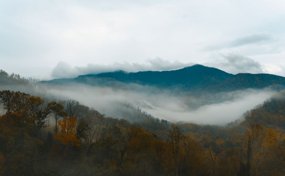
Great Smoky Mountains National Park straddles the crest of the Smokies on the Tennessee–North Carolina border and is the most visited national park in the United States. Its forested ridges, wrapped in the blue haze that gives them their name, rise to 6,643 ft (2,025 m) at Kuwohi and shelter waterfalls, old-growth forest, an astonishing variety of wildflowers and salamanders, and one of the densest populations of black bears in the country. Log cabins, churches and mills in valleys such as Cades Cove keep the story of the mountain farmers alive, and elk graze the fields on the North Carolina side. There is no entrance fee, but you need a parking tag to stop for more than 15 minutes. Gatlinburg, Tennessee, and Cherokee, North Carolina, sit at the two main entrances, joined by Newfound Gap Road over the mountains.
Right now in Great Smoky Mountains National Park (Sugarlands)
- Wed14–24°C58–75°FClear
- Thu18–26°C64–78°FClear
- Fri16–27°C61–81°FCloudy
- Mon 12 Oct Columbus Day · regional holiday in Tennessee
Top tours in Great Smoky Mountains National Park
See all tours for Great Smoky Mountains National Park →
From local operators, with prices and reviews; you check availability and book on Viator, our partner. We may earn a commission at no extra cost to you. How we earn money
Great Smoky Mountains at a glance
- Best months: mid-April–May for wildflowers and mid-October–early November for fall color; summer is warm, humid and busy; winter is quiet, with snow and road closures up high.
- Time needed: one full day for Newfound Gap Road, Kuwohi and a short hike; three or four days to add Cades Cove, Roaring Fork, a long hike and the elk of Cataloochee or Oconaluftee.
- Getting there: Gatlinburg is about 45 miles (72 km) from Knoxville’s McGhee Tyson Airport (TYS); Cherokee is about 60 miles (97 km) from Asheville’s airport; Atlanta is about 3.5 hours away by car.
- Fees (as of October 2026): no entrance fee; a parking tag costs $5 a day, $15 a week or $40 a year for any vehicle parked more than 15 minutes. America the Beautiful passes are not accepted instead.
- Before you go: entry rules for international visitors (ESTA or visa), driving and tipping are in our United States travel guide.
Parking tags: the “Park It Forward” fee (as of October 2026)
Great Smoky Mountains is one of the few large national parks with no entrance fee. Instead, under the park’s “Park It Forward” program, every vehicle parked anywhere in the park for more than 15 minutes must display a parking tag. You don’t need one to drive through or to stop briefly at an overlook. Tags are not tied to a particular place, and the price is the same for every type and size of vehicle.
| Tag | Price | Notes |
|---|---|---|
| Daily | $5 | One vehicle for one day; place face-up on the front passenger side of the dashboard |
| Weekly | $15 | Seven consecutive days; display as above |
| Annual | $40 | 12 months; stick to the lower front passenger side of the windshield |
Where to buy: online on Recreation.gov (daily and weekly tags, which you must print) or from the Smokies Life store (annual tags, mailed to you); in person at the park’s visitor centers and nearby welcome centers, including Sugarlands, Oconaluftee, Cades Cove and the Gatlinburg Welcome Center, and at several REI stores in the region; or at 13 self-service machines at trailheads and overlooks, open around the clock. Each tag is valid for one vehicle and must match its license plate; digital copies are not accepted, and tags cannot be refunded, replaced, transferred or upgraded. A tag does not guarantee a parking space. Vehicles with a state disability placard or plate are exempt. America the Beautiful passes, including Senior, Access and Military passes, are not accepted in place of a tag. On the remaining 2026 fee-free days, October 27 and November 11, no tag is required.
Hurricane Helene: what is open and closed in October 2026
Remnants of Hurricane Helene caused severe flooding in the park and across western North Carolina in late September 2024. The park closed Newfound Gap Road, Kuwohi Road, Foothills Parkway East and the Balsam Mountain, Big Creek and Cataloochee areas while crews assessed damage. The main roads reopened soon after, and portions of Cataloochee Valley reopened in April 2025. As of the park’s closures page updated October 2, 2026, most of the park is open, but these Helene-related restrictions remain:
- Big Creek: the Big Creek Trail is open only for its first 2 miles (3.2 km), to Mouse Creek Falls; Swallow Fork Trail and Gunter Fork Trail are closed. Backcountry campsites 41 and 42 are closed, and 39 and 40 are closed to horses.
- Cataloochee: Caldwell Fork Trail is closed; Rough Fork, Pretty Hollow Gap and Hemphill Bald trails are open to hikers but closed to horses. Cataloochee Road is open, and many footbridges lost in the flood have not yet been replaced, so expect wet crossings and downed trees.
- Balsam Mountain: the gravel Heintooga Round Bottom Road and Straight Fork Road have no 2026 opening date (“to be determined”) because of Helene damage; the paved Heintooga Ridge Road from the Blue Ridge Parkway has its normal season to October 31. Hyatt Ridge, Enloe Creek and Camel Gap trails are closed to horses.
- Interstate 40 in the Pigeon River Gorge: the main highway between Knoxville and Asheville past the park’s northeast corner reopened on March 1, 2025, with one lane in each direction, a 35 mph limit and narrow shoulders over about 12 miles (19 km) between Exit 7 in North Carolina and Exit 447 in Tennessee; oversize loads must detour. The North Carolina Department of Transportation expects all lanes to reopen in late 2028. Allow extra time and check DriveNC.gov.
Other closures not caused by the storm: Laurel Falls Trail is closed for rebuilding, with reopening expected in 2027; Bullhead Trail is closed Monday to Thursday through November 19, 2026; Scott Mountain Trail is closed between campsite 6 and Schoolhouse Gap; Carlos Campbell Overlook on Newfound Gap Road and Mingus Mill are temporarily closed; and several backcountry sites are closed for bear activity. The Blue Ridge Parkway, which begins at Oconaluftee, is a separate park with its own closures (828-298-0398). Check the park’s closures page before you go.
Newfound Gap Road, Kuwohi and the scenic drives
Newfound Gap Road (US 441) is open all year, weather permitting, and crosses the park for about 33 miles (53 km) between Gatlinburg and Cherokee. It climbs through hardwood forest to Newfound Gap, at about 5,046 ft (1,538 m) on the state line, where the Appalachian Trail crosses and the Rockefeller Memorial marks the park’s 1940 dedication; then it descends past the Oconaluftee River to the Oconaluftee Visitor Center and the Mountain Farm Museum. Snow and ice close it several times most winters. GPS directions are often wrong in the mountains, so carry a park map.
Kuwohi (formerly Clingmans Dome; its Cherokee name, meaning “mulberry place”, was restored in September 2024) is the highest point in the park. The 7-mile (11 km) Kuwohi Road leaves Newfound Gap Road near the gap and is open in 2026 from April 1 to November 29, weather permitting. From the parking area a paved but very steep trail climbs 0.5 mile (0.8 km) to the 1959 observation tower, whose 375-ft (114 m) spiral ramp leads to a 360-degree view when the summit is not in cloud. Parking often fills on fine days; arrive early or late.
| Road | 2026 season | Notes |
|---|---|---|
| Newfound Gap Road (US 441), Little River Road, Cades Cove Loop | All year | Weather closures; Cades Cove sunrise to sunset |
| Kuwohi Road | April 1 – November 29 | Paved; weather closures |
| Roaring Fork Motor Nature Trail | April 17 – November 29 | One-way, very steep; vehicle restrictions |
| Rich Mountain Road | April 10 – November 9 | One-way gravel out of Cades Cove |
| Parson Branch Road | May 1 – November 9 | One-way, 8 miles; high clearance recommended |
| Heintooga Ridge Road | May 15 – October 31 | Paved, from the Blue Ridge Parkway |
| Cataloochee Road | All year | Narrow gravel; weather closures possible |
Cades Cove
Cades Cove is a broad, green valley ringed by mountains, where 19th-century settlers built farms, three churches and a working gristmill that still stand. An 11-mile (18 km) one-way loop road circles it, open from sunrise to sunset; allow at least two to four hours, longer if you stop to hike, because traffic often slows to a crawl behind people watching white-tailed deer, wild turkeys and black bears. Use the pullouts rather than stopping in the road. The Cades Cove Visitor Center, halfway around near the Cable Mill, sells parking tags, and bicycles can be rented by the campground store. The loop is closed to cars on Wednesdays, typically from May through September, for walkers and cyclists; it is open to vehicles every day from October. On busy October weekends, come at opening time.
Bears, elk and safety
About 1,900 black bears live in the park, roughly two per square mile. It is illegal to approach within 50 yards (150 ft) of a bear, or any distance that disturbs it, and the fines for feeding wildlife or leaving food out can reach $5,000 and six months in jail. If a bear approaches, stand your ground, make noise and back away slowly; never run. If a bear attacks and it is not after food, fight back. Bears are most active from May to August, and all food and coolers must be stored in your vehicle or the bear cables in camp.
Elk were reintroduced to the park in 2001 and live on the North Carolina side, mainly in Cataloochee Valley and the fields beside the Oconaluftee Visitor Center, and also around Balsam Mountain. They are easiest to see in early morning and evening. Keep at least 25 yards (75 ft) away, or farther if they change their behavior; approaching closer is illegal. The fall rut, from early September to late October, is the most spectacular and the most dangerous time, when bulls bugle and spar. Other common emergencies are falls near waterfalls and on wet rocks, swift water after rain, and getting lost or caught out after dark; carry a light and a map, as phone signal is poor in much of the park.
Top things to see in the Smokies
Roaring Fork Motor Nature Trail
Just outside Gatlinburg, this narrow, one-way loop road winds through dense forest past rushing streams, old log cabins and a tub mill, with the trailhead for Grotto Falls, where the path goes behind a 25 ft (8 m) waterfall. The drive itself takes about 30 minutes, but allow longer to stop. It is open from April 17 to November 29 in 2026; buses, trailers and RVs are not allowed.
Alum Cave Trail and Mount LeConte
From the Alum Cave trailhead on Newfound Gap Road, a beautiful, steep and rocky trail follows a creek, passes through Arch Rock and climbs to Alum Cave Bluffs, an 80 ft (24 m) overhanging cliff, 4.6 miles (7.4 km) round trip. Strong hikers continue to the summit of Mount LeConte, 10 miles (16 km) round trip, for views from Cliff Top and Myrtle Point and the rustic LeConte Lodge. Parking is very limited; arrive early, and bring microspikes for ice in winter. Pets are not allowed.
Chimney Tops
A short but very steep trail from Newfound Gap Road leads 3.5 miles (5.6 km) round trip to an observation point facing the twin rock pinnacles of the Chimney Tops. The final scramble to the summit, where the 2016 wildfire started, remains closed. Expect a strenuous climb and crowds on weekends.
Waterfalls
With Laurel Falls closed until 2027, good alternatives near Gatlinburg include the easy 0.7-mile (1.1 km) walk to 40 ft (12 m) Cataract Falls from Sugarlands Visitor Center, Grotto Falls on Roaring Fork and the longer hike to 95 ft (29 m) Hen Wallow Falls from Cosby. On the North Carolina side, Deep Creek near Bryson City has three waterfalls on short loop trails, and Mingo Falls is just outside the park on Cherokee land.
Oconaluftee and the Mountain Farm Museum
Near Cherokee, the Oconaluftee Visitor Center sits beside the Mountain Farm Museum, a collection of log buildings moved here from across the Smokies, and the Oconaluftee River Trail, one of only two park trails open to dogs and bicycles. Elk often graze in the fields at dawn and dusk. The Blue Ridge Parkway starts close by.
Nature
- Alum Cave Trail
- Laurel Falls Trail
Peaks and mountains
- Chimney Tops
- Kuwohi
- Mount Le Conte
Museums
- Mountain Farm Museum
Other things to do in the Smokies
- Hiking: more than 800 miles (1,300 km) of trails, including about 70 miles (113 km) of the Appalachian Trail along the crest; Charlies Bunion from Newfound Gap is a classic day hike. See our hiking guide.
- Synchronous fireflies: for about two weeks between late May and mid-June, fireflies at Elkmont flash in unison. Viewing is by lottery on Recreation.gov: in 2026 applications ran April 24–27 for viewing nights May 20–27, with a $1 application fee and a $29 reservation fee for winners. Expect the 2027 lottery to be announced in spring.
- Cycling: the Cades Cove Loop on vehicle-free Wednesdays (May–September) is a favorite ride; see our cycling guide.
- History: Elkmont’s abandoned resort cottages, the churches and cabins of Cataloochee, and the Mountain Farm Museum show how people lived here before the park.
- Fishing and picnics: fishing for trout and bass is allowed in most streams with a Tennessee or North Carolina license; Cades Cove, Deep Creek, Greenbrier and Metcalf Bottoms picnic areas are open all year.
Activities and best months
- HikingThe park charges no entrance fee, but every vehicle parked for more than 15 minutes needs a parking tag ($5 a day, $15 a week, $40 a year).
Getting there
The three main entrances are Gatlinburg (Interstate 40 Exit 407, then US 441 through Sevierville and Pigeon Forge), Townsend (US 321) and Cherokee, North Carolina (I-40 Exit 27, US 74 and US 19, then US 441). There is no public transport into the park; rent a car.
| From | Distance | Route and time |
|---|---|---|
| Knoxville, TN (TYS airport) | about 45 miles (72 km) to Gatlinburg | Via Pigeon Forge or Townsend; about 1–1.25 hours |
| Asheville, NC (AVL airport) | about 60 miles (97 km) to Cherokee | Interstate 40 and US 74; about 1.25 hours |
| Atlanta, GA (ATL airport) | about 165 miles (266 km) to Cherokee | Via US 23/441 through north Georgia; about 3.5 hours |
| Nashville, TN (BNA airport) | about 220 miles (354 km) to Gatlinburg | Interstate 40 east; about 4 hours (Eastern Time is one hour ahead) |
| Charlotte, NC (CLT airport) | about 170 miles (274 km) to Cherokee | Interstate 40 west; about 3 hours |
Many visitors fly into Knoxville or Asheville, or into Atlanta or Charlotte for more flight choice. The Gatlinburg Trolley and local shuttle companies serve the towns, but not the park’s trailheads.
Around the Smokies
- Gatlinburg: the busiest gateway, a walkable mountain resort town at the park’s edge with a free trolley, attractions and countless cabins.
- Pigeon Forge and Sevierville: family attractions, outlet malls and Dollywood, 15–30 minutes north of the park.
- Townsend: the “peaceful side of the Smokies”, close to Cades Cove, with tubing on the Little River.
- Cherokee and Bryson City: on the North Carolina side, with the Museum of the Cherokee People, the Great Smoky Mountains Railroad from Bryson City and access to Deep Creek and Oconaluftee.
Nearby destinations
- Gatlinburg14 km
- Asheville79 km
- Atlanta224 km
When to go and how long to stay
Elevation in the park ranges from about 875 ft (267 m) to 6,643 ft (2,025 m), and the climate changes with it: temperatures can be 10–20 °F (6–11 °C) cooler on the peaks than in the valleys, and Kuwohi gets about 85 inches (2,160 mm) of rain a year against about 55 inches (1,400 mm) in Gatlinburg. Spring brings waterfalls and wildflowers, but snow is possible up high into April. Summer is hot and humid in the valleys, rarely above 80 °F (27 °C) on the peaks, with frequent afternoon thunderstorms. Fall color starts at the highest elevations as early as mid-September, peaks above 4,000 ft (1,200 m) in early to mid-October, and reaches the lower slopes from mid-October to early November, the busiest weeks of the year. Winter is mild in the valleys, but storms can drop up to 2 ft (60 cm) of snow up high and close the mountain roads.
| Season | Average high | Average low | What it’s like |
|---|---|---|---|
| Spring (Mar–May) | 59–75 °F (15–24 °C) | 35–51 °F (2–11 °C) | Wildflowers and waterfalls; changeable; snow up high early on. |
| Summer (Jun–Aug) | 80–83 °F (27–28 °C) | 59–63 °F (15–17 °C) | Warm, humid, wettest months; storms; fireflies in June. |
| Fall (Sep–Nov) | 78–58 °F (26–14 °C) | 56–34 °F (13–1 °C) | Driest season; elk rut and fall color; heavy traffic in October. |
| Winter (Dec–Feb) | 47–51 °F (8–11 °C) | 27–29 °F (−3 to −2 °C) | Quiet; snow and road closures at high elevations. |
Figures are NOAA 1991–2020 normals for the Gatlinburg 2 SW station near Sugarlands Visitor Center, at about 1,450 ft (443 m), with about 58 inches (1,478 mm) of rain and 8 inches (20 cm) of snow a year. Expect much colder, wetter and windier conditions at Newfound Gap and Kuwohi.
Weather month by month
The Smokies in one day
Start early at Sugarlands Visitor Center for a map and a parking tag, walk to Cataract Falls, then drive Newfound Gap Road to the gap and up to Kuwohi for the view. Continue down to Oconaluftee to look for elk in the evening, or return to Gatlinburg via the Roaring Fork Motor Nature Trail.
Three or four days
Give one morning to Cades Cove from opening time, another to a big hike such as Alum Cave or Charlies Bunion, and spend a day on the North Carolina side with Cataloochee’s elk and historic buildings (a slow drive on gravel) or the waterfalls of Deep Creek.
Where to stay near the Smokies
- LeConte Lodge: the only lodging inside the park, near the summit of Mount LeConte at 6,593 ft (2,010 m), reached only on foot by trails of 5 to 8 miles (8–13 km). Rustic cabins with meals are generally open from mid-March to mid-November and book up far ahead.
- Campgrounds: ten developed campgrounds; Cades Cove and Smokemont are open all year, the others seasonally, including Elkmont near Gatlinburg. Reservations are required on Recreation.gov or at 877-444-6777.
- Gatlinburg: hotels and cabins steps from the park; the most convenient base on the Tennessee side.
- Pigeon Forge, Townsend, Cherokee and Bryson City: more choice and often lower prices; Townsend is best for Cades Cove, Cherokee and Bryson City for Oconaluftee, Deep Creek and Cataloochee.
Room taxes: room rates are quoted before tax. In Gatlinburg the total is 12.75% (the city’s 3% hotel/motel tax plus 9.75% Tennessee state and local sales tax). Other gateway towns in Tennessee and North Carolina set their own occupancy taxes; check the total when you book, along with any cabin cleaning fees.
Practical tips for the Smokies
- Arrive early: trailhead parking at Alum Cave, Chimney Tops, Kuwohi and Cades Cove fills by mid-morning on weekends and every day in October; have a backup plan.
- Check closures on the park’s website on the day: Helene repairs, trail work, weather and bear activity change what is open.
- Food and fuel: there are no restaurants or gas stations inside the park; stock up in the gateway towns.
- Pets and drones: dogs are allowed only on the Gatlinburg and Oconaluftee River trails and in campgrounds and picnic areas, on a leash; drones are not allowed.
- Time zone: the whole park, in both states, is on Eastern Time with daylight saving time, one hour ahead of Nashville.
- Phone signal is unreliable; download maps and the NPS app before you go. Emergencies: call 911.
What to pack for the Smokies
Bring a rain jacket in every season, because it rains often, plus warm layers for the high peaks, which can be 10–20 °F (6–11 °C) colder than town. Pack hiking shoes with good grip for wet roots and rocks, a refillable water bottle and water treatment for long hikes, snacks, a headlamp, a paper map and insect repellent in summer. For winter visits, add a warm hat, gloves and microspikes for icy trails. Binoculars make wildlife watching at a legal distance far more rewarding.
What to pack
- Day packs and anti-theft bagsA 20–30 litre pack carries layers, water, a head torch and snacks on full-day levada walks.
- Fleeces and warm layersSummits like Pico do Areeiro averaged about 11 °C over 2024, so a fleece is needed even in summer.
- HeadlampsLevada routes such as PR1 and PR9 pass through long, dark, wet tunnels.
- Hiking shoes and bootsMadeira's levadas and the Azores' crater rims are wet, rocky and slippery, so grippy shoes matter more than anywhere else in Portugal.
- Rain jacketsMountain and island weather changes fast; a real shell beats an umbrella in the wind.
- Trekking polesLong stone staircases and steep descents on Madeira's peaks and the Azores' crater rims are easier on the knees with poles.
- Water bottles and hydration packsAlgarve and Alentejo trails are hot and exposed with few refill points.
Great Smoky Mountains travel FAQ
Is there an entrance fee for Great Smoky Mountains National Park?
No. But any vehicle parked in the park for more than 15 minutes needs a parking tag: $5 a day, $15 a week or $40 a year. America the Beautiful passes do not replace the tag.
Where can I buy a Smokies parking tag?
Online on Recreation.gov (print it), at visitor centers such as Sugarlands, Oconaluftee and Cades Cove, the Gatlinburg Welcome Center, some regional REI stores, or 13 self-service machines at trailheads. Annual tags are also sold online by Smokies Life.
Is the park still affected by Hurricane Helene?
Mostly not. Main roads and visitor areas are open, but as of October 2026 parts of Big Creek and Cataloochee trails are closed, Heintooga Round Bottom and Straight Fork roads have no reopening date, and I-40 through the Pigeon River Gorge has one lane each way until about late 2028.
Is Clingmans Dome Road open?
The peak is now called Kuwohi. Kuwohi Road is open from April 1 to November 29 in 2026, weather permitting; from the parking area it is a steep half-mile walk to the observation tower.
Is Laurel Falls Trail open?
No. It closed in January 2025 for rehabilitation, and the park expects to reopen it in 2027. Try Cataract Falls or Grotto Falls instead.
When is Cades Cove closed to cars?
On Wednesdays, typically from May through September, when the loop is reserved for walkers and cyclists. The rest of the year it is open to vehicles daily from sunrise to sunset.
How do I see the synchronous fireflies?
Enter the Recreation.gov lottery, usually held in late April for viewing at Elkmont in late May or June. In 2026 it cost $1 to apply and $29 if you won.
Where can I see elk in the Smokies?
In Cataloochee Valley and the fields by the Oconaluftee Visitor Center in North Carolina, early in the morning or in the evening. Stay at least 25 yards (75 ft) away, more during the fall rut.
When is the best time for fall color in the Smokies?
Early to mid-October above 4,000 ft, and mid-October to early November in the lower valleys. It is the busiest time of year, so start early and visit midweek if you can.
Plan your trip
Partner links: TravelerCenter may earn a commission if you book, at no extra cost to you.
Sources · last reviewed 5 Oct 2026
Researched and last reviewed on October 4, 2026. Parking tag prices and rules, fee-free days, Helene and other closures, seasonal road dates, Cades Cove, Kuwohi, trail distances, bear and elk rules, fireflies, fall color, weather by elevation, LeConte Lodge, campgrounds and entrances come from Great Smoky Mountains National Park (National Park Service); the I-40 Pigeon River Gorge status from the North Carolina Department of Transportation; Gatlinburg’s room tax from the City of Gatlinburg; climate from NOAA’s 1991–2020 normals for the Gatlinburg 2 SW station. Distances from Atlanta, Nashville and Charlotte, the length of Newfound Gap Road and Kuwohi Road, the elevation of Newfound Gap, trail mileage totals and some gateway details are general references and flagged for checking. Conditions change quickly, so check the park’s closures page before you travel. For entry rules, driving and tipping, see our United States travel guide.
Also: nps.gov · NOAA NCEI normals 1991–2020, Gatlinburg 2 SW (climate)
Data: Weather: MET Norway (CC BY 4.0) · Rates: ECB · Holidays: Nager.Date · Costs: World Bank ICP and price levels · © OpenStreetMap contributors (ODBL) · Wikidata (CC0)