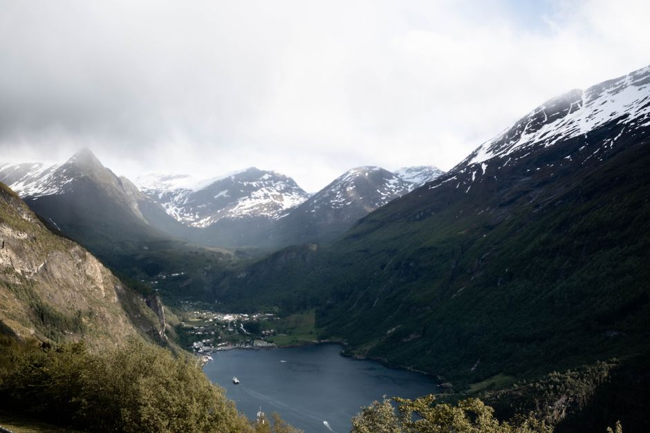
The Geirangerfjord is the picture many people have of Norway: a deep, narrow, S-shaped arm of the sea about 15 km long, between mountain walls more than 1,000 m high, with waterfalls such as the Seven Sisters tumbling down the cliffs and abandoned farms clinging to ledges high above the water. Together with the Nærøyfjord, it has been a UNESCO World Heritage Site since 2005 as the West Norwegian Fjords. At its head lies the small village of Geiranger, reached by hairpin roads from the mountains and by boat. You come to sail the fjord, look down on it from the viewpoints of Dalsnibba, Flydalsjuvet and the Eagle Road, hike to the cliff farms and walk behind a waterfall. Give it at least one night, two or three to explore properly; it is a fine stop on a road trip that also takes in Trollstigen and Ålesund.
Right now in Geirangerfjord (Geiranger)
- Thu5–10°C41–49°F2 mm rain
- Fri5–12°C42–53°F3 mm rain
- Sat7–10°C44–50°FCloudy
Top tours in Geirangerfjord
See all tours for Geirangerfjord →
From local operators, with prices and reviews; you check availability and book on Viator, our partner. We may earn a commission at no extra cost to you. How we earn money
Geiranger at a glance
- Best months: late May to September, when all the mountain roads, boats and viewpoints are open; late May and June for the fullest waterfalls and snow on the peaks; September for calmer days and autumn colours.
- Time needed: a full day for a fjord cruise and the viewpoints; 2–3 days to add hikes to Skageflå or Westerås and a drive over the Eagle Road to Trollstigen.
- Getting there: by road from Ålesund (about 2.5–3 hours with a ferry), from the east over the mountain road from Grotli (summer only), by the car ferry from Hellesylt in summer, by sightseeing boat from Ålesund, or on a cruise ship.
- Fjord cruises (as of October 2026): 75-minute and 2-hour sightseeing cruises from the village from NOK 610; silent hybrid-electric 2-hour cruises from NOK 695.
- Winter: the village is quiet and many businesses close; the road to Dalsnibba and the mountain road east are closed, but the Eagle Road usually stays open and winter fjord cruises run from Ålesund.
The fjord and the village
The Geirangerfjord is the innermost branch of the long Storfjord system, which runs about 100 km inland from the coast near Ålesund. Hellesylt, a small village with a waterfall in its centre, sits where the Geirangerfjord meets the Sunnylvsfjord; Geiranger village, with about 250 permanent residents, is at the head of the fjord, where the valley climbs steeply towards the mountains. Most hotels, campsites, cafés and the Norwegian Fjord Centre are in or just above the village, and the road zigzags up both sides of the valley: north on the Eagle Road (Ørnevegen) and south-east towards Flydalsjuvet and Dalsnibba.
Geiranger is one of Norway’s busiest cruise ports, and in summer one or more large ships often anchor in the fjord, bringing thousands of visitors for the day. Norway has decided that ships in the World Heritage fjords must become zero-emission, starting with smaller passenger ships and extending to large cruise ships by 2032, and electric sightseeing boats and ferries already sail here. Mornings and evenings are much calmer than the middle of the day.
Top things to see in Geiranger
The Seven Sisters, the Suitor and the Bridal Veil
The fjord’s famous waterfalls face each other across the water: the Seven Sisters (De syv søstrene), seven streams falling side by side down a 250 m cliff on the north side, and opposite them the Suitor (Friaren), said to be courting the sisters in vain, plus the Bridal Veil (Brudesløret). They are at their most powerful in late May and June when the snow melts, and thinner by late summer. You see them best from a boat; the Geiranger–Hellesylt ferry and every sightseeing cruise pass close by.
Dalsnibba (Geiranger Skywalk)
A toll road climbs from the Geiranger–Grotli road to the summit of Dalsnibba, 1,500 m above sea level, which its owners call Europe’s highest fjord view from a road. It is about 21 km from the village, around 30 minutes’ drive with 11 hairpin bends near the top. At the summit there is a viewing platform with a glass edge over the drop, a café, shop and toilets, all accessible. Pay the toll at the booth on arrival. The road is open in the summer season, during daytime only early and late in the season, and closes at short notice when there is snow or ice; it closed for snow on 24 September 2026, for example. Check the road status and the webcam on dalsnibba.no before you go. Visit Geiranger runs bus trips, and you can rent e-bikes or small electric cars in the village.
Flydalsjuvet
A few minutes’ drive above the village on the road towards Dalsnibba, this viewpoint has the classic postcard view of the fjord framed by a rocky overhang, with the cruise ships far below. There are platforms and a car park; the overhanging rock itself is exposed, so take care.
The Eagle Road and Ørnesvingen
The Eagle Road (Ørnevegen), opened in 1955, climbs from the north side of the village in 11 hairpin bends to Ørnesvingen, the “eagle bend”, a viewpoint about 620 m above the fjord with a platform looking straight down the fjord to the Seven Sisters. The road continues to Eidsdal, where a short ferry crosses to Linge on the way to Valldal and Trollstigen. It is the only road to Geiranger that usually stays open all winter.
The Norwegian Fjord Centre
The World Heritage visitor centre just above the village explains how the fjords were carved by glaciers, how people farmed these impossible slopes and why rockfalls and tsunamis are a real risk here: the Åkerneset mountainside in the neighbouring Sunnylvsfjord is one of the most closely monitored unstable slopes in Norway. A good stop on a rainy day; check opening hours and prices locally.
Storseterfossen, Westerås and the waterfall walk
From the Westerås farm above the village, a marked path leads to Storseterfossen, a waterfall you can walk behind, about 1.5 hours return from the farm. In the village itself, a series of steps and paths (the Fossevandring) climbs beside the Geirangelva river and its waterfalls from the fjord to the Fjord Centre.
Nature
- Seven Sisters waterfall
Peaks and mountains
- Blåhornet
- Dalsnibba
- Keipen
Churches and cathedrals
- Geiranger Church
Fjord cruises, kayaks and ferries
There are several ways to get out on the water. Prices are as of October 2026, from VISIT Geiranger, the main local boat operator; departures are frequent in summer and limited outside it.
- Sightseeing cruises from Geiranger: 75-minute and 2-hour round trips past the Seven Sisters and the cliff farms, from NOK 610; a 2-hour silent cruise on a hybrid-electric catamaran from NOK 695. Boats leave from behind the tourist information in the main harbour.
- From Ålesund: a silent fjord cruise sails from Skutvika in Ålesund to Geiranger, about 9 hours there and back, from about NOK 1,070 one way for adults (children half price). From November to May a winter and spring fjord cruise day trip runs from Ålesund, from NOK 1,539.
- The Geiranger–Hellesylt ferry: in summer, a car ferry sails the whole length of the Geirangerfjord to Hellesylt in about an hour, a good way to see the fjord if you are driving through. Check the current season and operator before you plan around it.
- RIB safaris and kayaks: fast RIB boat trips, and guided kayak trips of 2.5 or 4 hours (the longer one to the Seven Sisters), or kayak rental for experienced paddlers.
See our boat trips page for more fjord cruises around Europe.
Hiking: Skageflå and the cliff farms
The steep slopes above the fjord were farmed until the mid-20th century, and the abandoned farms make spectacular hikes. Skageflå, on a ledge about 250 m above the fjord opposite the Seven Sisters, is the best known: take a boat drop-off at the foot of the path (VISIT Geiranger’s boat transport costs from NOK 610) and climb the steep path up, then walk back over the mountain to Geiranger, 4–5 hours in all. Homlongsetra, Vinsåshornet and the paths around Westerås offer more views. The trails are steep, rocky and slippery when wet; wear proper hiking shoes and check the weather on yr.no.
Activities and best months
- Boat tripsFjord cruises run from Ålesund to the Geirangerfjord all year, and a car ferry links Hellesylt and Geiranger; RIB safaris and kayaking operate in season. From the water you see the Seven Sisters, the Suitor and the Bridal Veil waterfalls.
- HikingHikes around Geiranger include the Fosseråsa national trail and walks to old mountain farms such as Skageflå above the fjord; the Geiranger Skywalk on Dalsnibba (1,500 m) is reached by car.
Getting there and getting around
By road
Geiranger lies on route 63. From the north, it comes from Åndalsnes over Trollstigen and Valldal, crosses the Norddalsfjord on the Linge–Eidsdal ferry and drops into Geiranger down the Eagle Road; Ålesund is about 2.5–3 hours away this way or via Hellesylt. From the east, the road climbs from Geiranger past Dalsnibba to the Strynefjellet mountains and Grotli, where it meets route 15 to Lom and Otta; this high mountain stretch is closed in winter, usually from about November to May. Trollstigen is also a summer-only road, usually open from late May or June until October or November. Check road status and closures with the Norwegian Public Roads Administration (vegvesen.no/trafikk) before you drive, especially early and late in the season. The roads are narrow, with many hairpins, tunnels and campervans; allow plenty of time.
By bus, boat or coastal ship
In summer, buses link Geiranger with Ålesund, Hellesylt, Stryn and Åndalsnes, and VISIT Geiranger runs a shuttle bus between Eidsdal and Geiranger. The sightseeing boat from Ålesund is a scenic way in. The Hurtigruten coastal ships call at Geiranger on some northbound summer sailings, and at Hjørundfjorden or other fjords at other times of year; check the season when you book. There is no railway; the nearest stations are at Åndalsnes and Otta.
In the village
The village is small and walkable, but steep. E-bikes and small electric cars can be rented for the viewpoints, and guided bus and electric-car tours go up to Flydalsjuvet, Ørnesvingen and Dalsnibba.
Around Geiranger: Trollstigen, Ålesund and Hellesylt
- Trollstigen: the “Troll’s Ladder”, a mountain road of 11 hairpin bends below the Stigfossen waterfall, with a modern visitor centre and viewing platforms at the top; about 1.5–2 hours from Geiranger via the Eagle Road and the Linge ferry. Summer only.
- Ålesund: a harbour town rebuilt in Art Nouveau style after a fire in 1904, with the Aksla viewpoint above the centre; the nearest airport (Vigra) and a good base for a fjord day trip.
- Hellesylt and the Norangsdalen: a ferry-port village with a roaring waterfall, and a dramatic valley road through the Sunnmøre Alps to the Hjørundfjord.
- Valldal: the “strawberry village” on the road to Trollstigen, with fruit stalls in summer.
When to go and how long to stay
The inner fjords are drier and warmer in summer than the coast, but the mountains above can be cold and snowy well into June. There is no long-term climate station in Geiranger itself, so the table uses MET Norway’s 1991–2020 climate normals for Tafjord, at the head of the neighbouring Norddalsfjord about 30 km away, as submitted to the World Meteorological Organization. At Dalsnibba and the other high viewpoints it is often 10 °C colder, with snow possible in any month.
| Season | Average daily high | Average night low | Rain per month | What it’s like |
|---|---|---|---|---|
| Winter (Dec–Feb) | 4.5–5.4 °C | -1.1 to -0.4 °C | 99–123 mm | Quiet, dark and snowy above the village; mountain roads closed, many businesses shut |
| Spring (Mar–May) | 6.7 °C rising to 15.2 °C | 0.4–6.0 °C | 94 falling to 44 mm | Snowmelt and roaring waterfalls in May; mountain roads reopen from mid- to late May |
| Summer (Jun–Aug) | 18.0–20.0 °C | 9.1–11.7 °C | 55–67 mm | Everything open, long light evenings, busiest with cruise ships and road-trippers |
| Autumn (Sep–Nov) | 15.8 °C falling to 7.8 °C | 8.5 falling to 2.2 °C | 90–105 mm | Calmer and colourful in September; boats and roads wind down in October |
Tafjord gets about 1,010 mm of rain a year on about 136 days, with May the driest month (44 mm) and December and January the wettest. July is the warmest month, with an average high of 20 °C. Low cloud can hide the peaks and viewpoints for a day or two at a time, so give yourself some flexibility.
Geiranger in 1 day
Take an early fjord cruise past the Seven Sisters, then drive or take a tour up to Flydalsjuvet and Dalsnibba, and finish at Ørnesvingen on the Eagle Road in the evening light, when the cruise passengers have gone.
Geiranger in 3 days
Add the boat drop-off and hike to Skageflå, the Fjord Centre and the waterfall walk, a kayak trip, and a day driving over the Eagle Road and the Linge ferry to Trollstigen, or along the fjord by ferry to Hellesylt and on to Ålesund.
Weather month by month
Where to stay in Geiranger
- In the village: a handful of large hotels with fjord views and a few smaller guesthouses, many open only from about May to September.
- Farms and cabins above the fjord: Westerås and other farm stays with cabins and wonderful views, quiet once the day-trippers leave.
- Campsites: by the fjord in the village and up the valley, with cabins as well as pitches.
- Hellesylt, Stranda, Valldal or Ålesund: cheaper or more available bases within a few hours, useful in peak season or out of season.
Rooms are limited and expensive in June, July and August; book several months ahead. Out of season, check that your hotel is actually open.
Practical tips for Geiranger
- Check the cruise-ship list: the local tourist office publishes which ships are in port; on busy days, do the viewpoints early or late and sail at midday.
- Check the roads: Dalsnibba, the Geiranger–Grotli road and Trollstigen can close at short notice in spring and autumn; look at vegvesen.no and dalsnibba.no.
- Fill up first: fuel, cash machines and supermarkets are limited in the village; stock up in Stranda, Stryn or Ålesund.
- Drive carefully: use passing places on single-track roads, give way to buses on hairpins and never stop in a bend for photos.
- Respect the World Heritage area: stay on paths, take your rubbish home, and don’t fly drones near the viewpoints, the ships or people.
- Book boats ahead in summer: popular cruise and kayak times sell out on busy days.
What to pack for Geiranger
Bring layers even in July: it can be warm and sunny in the village and cold, windy and snowy at Dalsnibba, 1,500 m higher. A waterproof rain jacket, a warm fleece, a hat and gloves for the viewpoints and the boat deck, sturdy hiking shoes for the farm trails and spray from the waterfalls, sunglasses and sun cream for the snow and water glare, and a refillable bottle (mountain water is excellent). Norway uses type C and F plugs; see our travel adapters guide.
What to pack
- Day packs and anti-theft bagsA 20–30 litre pack carries layers, water, a head torch and snacks on full-day levada walks.
- Dry bags and phone pouchesSpray soaks phones and cameras on open boats to the Algarve caves and on whale-watching trips.
- Fleeces and warm layersIt is cooler at sea than on land, especially on morning whale-watching trips.
- HeadlampsLevada routes such as PR1 and PR9 pass through long, dark, wet tunnels.
- Hiking shoes and bootsMadeira's levadas and the Azores' crater rims are wet, rocky and slippery, so grippy shoes matter more than anywhere else in Portugal.
- Rain jacketsA windproof, waterproof shell keeps you warm on open boats, where wind and spray cool you quickly.
- Reef-friendly sunscreenSun reflects off the water on cruises and cave tours.
- Trekking polesLong stone staircases and steep descents on Madeira's peaks and the Azores' crater rims are easier on the knees with poles.
- Water bottles and hydration packsAlgarve and Alentejo trails are hot and exposed with few refill points.
- Water shoesKayak and small-boat trips to the Algarve grottoes land on rock and wet sand.
Geiranger travel FAQ
What is the best time to visit Geiranger?
Late May to September, when the mountain roads, boats and viewpoints are open. Late May and June have the biggest waterfalls and snow on the peaks; July and August are warmest and busiest; September is calmer.
How much is a Geirangerfjord cruise?
As of October 2026, 75-minute and 2-hour sightseeing cruises from Geiranger cost from NOK 610, and the 2-hour silent hybrid-electric cruise from NOK 695. A one-way cruise from Ålesund to Geiranger costs from about NOK 1,070 for adults.
Can you visit Geiranger as a day trip from Ålesund?
Yes. The sightseeing boat from Ålesund takes about 9 hours there and back, with time in Geiranger, and from November to May a winter fjord cruise day trip runs. By car it is about 2.5–3 hours each way, so staying a night is more relaxing.
When is the road to Dalsnibba open?
Only in the summer season, roughly from late May or June into the autumn, and it closes at short notice for snow or ice (it closed for snow on 24 September 2026). Early and late in the season it is closed at night. Check the road status on dalsnibba.no; you pay the toll at the booth.
Is Trollstigen open?
Trollstigen is a summer road, usually open from late May or June until October or November, depending on snow and maintenance. Check the current status with the Norwegian Public Roads Administration before you set off.
Can you drive to Geiranger in winter?
Yes, from the north via the Eagle Road and the Linge–Eidsdal ferry, which usually stay open. The road east over the mountains to Grotli and the Dalsnibba road are closed in winter. Use winter tyres and drive with care.
Where is the best view of the Geirangerfjord?
Flydalsjuvet for the classic postcard view, Ørnesvingen on the Eagle Road for the view down the fjord to the Seven Sisters, and Dalsnibba for the highest, widest panorama. From the water, the ferry or a cruise brings you close to the waterfalls.
How do I hike to Skageflå?
The easiest way is a boat drop-off at the foot of the path (from NOK 610 as of October 2026), a steep climb to the farm and a walk back over the mountain to Geiranger, 4–5 hours in all. You can also hike up and down from the village side. Go in dry weather with good shoes.
Is Geiranger crowded with cruise ships?
On many summer days, yes: one or more big ships can bring thousands of passengers to the small village. Check the cruise-ship list and plan the viewpoints for the early morning or evening. Norway’s zero-emission rules for the World Heritage fjords will apply to large cruise ships from 2032.
How long should you stay in Geiranger?
At least one night, so you can enjoy the fjord in the quiet morning and evening. Two or three nights let you hike to the cliff farms and add Trollstigen or a kayak trip.
Plan your trip
Partner links: TravelerCenter may earn a commission if you book, at no extra cost to you.
🇳🇴 Useful Norwegian phrases for Geirangerfjord
All 38 Norwegian phrases: restaurant, hotel, emergencies, romance (printable) →
Sources · last reviewed 4 October 2026
Researched and last reviewed on 4 October 2026. Fjord cruises, the Ålesund boat, the winter cruise, kayaks, the shuttle bus and the Skageflå boat: VISIT Geiranger (geirangerfjord.no); Dalsnibba road, height, distance and status: Geiranger Skywalk Dalsnibba (dalsnibba.no); climate: MET Norway 1991–2020 normals for Tafjord (WMO collection). The Geiranger–Hellesylt ferry, road seasons for route 63 and Trollstigen, the zero-emission rules for the World Heritage fjords, coastal-ship calls, bus services and driving times come partly from general knowledge or secondary sources and are flagged for checking. Prices, timetables and rules change, so check the official links before you go.
Also: visitnorway.com · MET Norway normals 1991–2020, Tafjord (climate)
Data: Weather: MET Norway (CC BY 4.0) · Sea temperature: NOAA CoastWatch · Rates: ECB · Costs: World Bank ICP and price levels · © OpenStreetMap contributors (ODBL) · Wikidata (CC0)