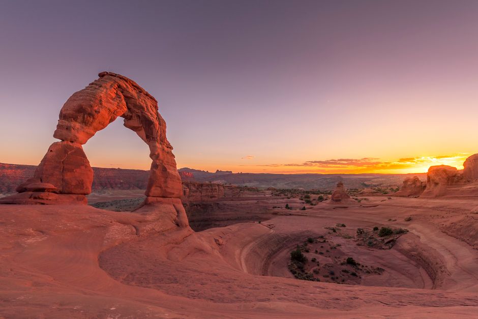
Arches National Park, just outside Moab in southeast Utah, holds more than 2,000 natural stone arches, along with soaring pinnacles, narrow sandstone fins and giant balanced rocks, all glowing red and orange against the snowy La Sal Mountains. A single paved scenic drive links the famous sights, from Balanced Rock and the Windows to Delicate Arch, the free-standing arch that has become a symbol of Utah, and Landscape Arch, the longest in North America. The park is open 24 hours a day all year, and in 2026 you do not need a timed-entry reservation to drive in. It is a high desert, though: summer days pass 100 °F (38 °C), late-summer storms bring flash floods, and shade is rare, so the best visits start early, end at sunset and leave time for the stars.
Right now in Arches National Park (Arches Visitor Center)
- Thu15–30°C58–86°FMostly clear
- Fri15–30°C58–85°FMostly clear
- Sat17–27°C63–81°F2 mm rain
- Mon 12 Oct Columbus Day · regional holiday in Utah
Top tours in Arches National Park
See all tours for Arches National Park →
From local operators, with prices and reviews; you check availability and book on Viator, our partner. We may earn a commission at no extra cost to you. How we earn money
Arches at a glance
- Best months: April–May and mid-September to October, when highs are about 60–80 °F (16–27 °C). These are also the busiest months; winter is quiet and cold.
- Time needed: half a day for the scenic drive and short walks; a full day to add Delicate Arch and Devils Garden; two days with the Fiery Furnace or a night of stargazing.
- Getting there: the entrance is 5 miles (8 km) north of Moab on US 191, 22 miles (35 km) south of Interstate 70 and about 236 miles (380 km) from Salt Lake City.
- Fees (as of October 2026): $30 per car for 7 days, $25 per motorcycle, $15 per person on foot or bike. Arches is not one of the parks with the $100 non-resident fee. No timed entry in 2026.
- Before you go: entry rules for international visitors (ESTA or visa), driving and tipping are on our United States travel guide.
Entrance fees and passes (as of October 2026)
Every visitor needs one entrance pass. Passes are sold at the Arches entrance station (credit and debit cards only) or online on Recreation.gov, and a standard pass lasts 7 days.
| Pass | Price | What it covers |
|---|---|---|
| Private vehicle | $30 | One non-commercial car or van (up to 15 seats) and everyone in it, 7 days |
| Motorcycle | $25 | Up to 2 motorcycles with up to 4 riders, 7 days |
| Per person (foot or bike) | $15 | Each person 16 or over; under-16s free |
| Southeast Utah Parks annual pass | $55 | Arches, Canyonlands, Natural Bridges and Hovenweep for 12 months; US citizens and residents |
| America the Beautiful pass | $80 residents / $250 non-residents | All national parks and federal recreation lands for 12 months |
For international visitors: in 2026, non-US residents aged 16 and over pay an extra $100 each at 11 busy national parks, including nearby Zion, Bryce Canyon and the Grand Canyon. Arches is not on that list, so you pay the same $30 per car as everyone else. If your road trip also takes in Zion, Bryce Canyon or the Grand Canyon, the $250 non-resident America the Beautiful pass, which covers one vehicle or four people paying per person, usually works out cheaper. US citizens and residents enter free on the two remaining fee-free days of 2026, 27 October and 11 November; non-residents pay the normal fee on those days.
US citizens and residents aged 62 and over can buy an annual America the Beautiful pass for $20 or a lifetime pass for $80; passes for US military, visitors with a permanent disability and families with a 4th grader are free.
Timed entry in 2026 and 2027
For 2026 the park has said plainly that advance timed-entry reservations are not required: you can enter at any time. Arches used timed-entry tickets in recent seasons, so you may still see old advice about booking an entry time. The catch in 2026 is congestion. When the parking lots fill, rangers temporarily stop or divert cars at the entrance, and these delays can last 3 to 5 hours. You may not wait on the highway or by the entrance sign; come back later or visit somewhere else nearby.
What about 2027? As of October 2026 the park has not announced whether timed entry will return in 2027; its timed-entry page shows only “being worked on.” If you are planning a visit between March and October 2027, check the park’s website and Recreation.gov early in the year. Reservations are still required for three things in 2026: Devils Garden Campground, ranger-led Fiery Furnace hikes and self-guided Fiery Furnace permits.
How to avoid the lines
More than 1.5 million people visit Arches each year, most of them between March and October. The park recommends entering before 8 a.m. or after 3 p.m. In summer many trailhead lots are full by 7:30 a.m., and entrance waits can pass an hour. The busiest times are Easter week, Memorial Day and Labor Day weekends and the mid-October Utah teachers’ (UEA) break. Use the restroom and fill your tank in Moab first: there is no fuel in the park and no restrooms along the entrance road. Check the entrance-road webcams on the park website, or tune to 1610 AM in Moab, before you set off.
Top things to see in Arches National Park
The scenic drive climbs from the visitor center past every major area. Driving times from the entrance, without stops:
| From the entrance to | Distance | Drive time |
|---|---|---|
| Balanced Rock | 9.2 miles (14.8 km) | 15–20 minutes |
| The Windows Section | 12 miles (19.3 km) | 25–30 minutes |
| Wolfe Ranch (Delicate Arch Trailhead) | 13.2 miles (21.2 km) | 30–35 minutes |
| Delicate Arch Viewpoint | 14.2 miles (22.8 km) | 30–35 minutes |
| Devils Garden | 18 miles (28.9 km) | 40–45 minutes |
Park Avenue and Courthouse Towers
The first big stop after the switchbacks above the visitor center. Sheer sandstone walls and monoliths line a dry wash like a city avenue of skyscrapers, and a trail runs down the middle between the Park Avenue and Courthouse Towers viewpoints.
Balanced Rock
A huge boulder perched on a slender pedestal right beside the road. A short trail circles its base, with views across to the Windows Section and the La Sal Mountains.
The Windows Section and Double Arch
Some of the largest arches in the park stand close together here: North Window and South Window, Turret Arch and, across the parking lot, the soaring twin spans of Double Arch. Short, easy trails reach all of them, which makes this the best area for families and anyone with limited time. Go early or late, as the lot is usually full through the middle of the day.
Delicate Arch and Wolfe Ranch
Delicate Arch stands alone on the edge of a slickrock bowl, with an opening 46 ft (14 m) high and 32 ft (10 m) wide, the largest free-standing arch in the park. You cannot really see it from the road. There are three ways to look:
- Lower Delicate Arch Viewpoint: a level 100-yard (91 m) walk to see the arch from a mile away.
- Upper Viewpoint: a 0.5-mile (0.8 km) walk with stairs for a slightly clearer view.
- Delicate Arch Trail: 3 miles (4.8 km) round trip from Wolfe Ranch, climbing steadily 480 ft (146 m) over open slickrock, past the Wolfe Ranch cabin and a panel of Ute petroglyphs, to stand beside the arch itself.
The trail has almost no shade, and rangers often rescue hikers who underestimated it, especially in summer heat or on winter ice. Sunset is magical but busy, with sometimes hundreds of people at the arch, so bring a headlamp for the walk down. If the Wolfe Ranch lot is full, you can park at the viewpoint lot, but that adds a mile each way along the road (5 miles / 8 km round trip in all).
Devils Garden and Landscape Arch
At the very end of the road, 18 miles (29 km) from the visitor center, Devils Garden is a maze of tall sandstone fins and arches. The easy, mostly flat walk to Landscape Arch (1.9 miles / 3.1 km round trip) leads to a ribbon of rock 306 ft (93 m) long, the longest arch in North America and only 6 ft (1.8 m) thick at its narrowest; large slabs fell from it in the 1990s.
Beyond Landscape Arch the trail turns difficult: hikers scramble up and along narrow fins with drop-offs to reach Double O Arch (4.1 miles / 6.6 km round trip), with side trips to Navajo and Partition arches. The full loop back on the Primitive Trail, with route finding, steep slickrock and a pool that may hold water, is 7.9 miles (12.6 km) with all the spurs. It is not recommended when the rock is wet or icy, or if you are uneasy with heights.
The Fiery Furnace
Between the Windows and Devils Garden lies the Fiery Furnace, a natural labyrinth of narrow passages between towering sandstone walls. There is no ordinary trail: you squeeze through gaps, jump small crevices and brace yourself between walls. You may enter only with a ranger or with a permit.
- Ranger-led hike: $16 per person, offered spring through autumn. Book on Recreation.gov up to 7 days ahead (877-444-6777, or +1 518-885-3639 from abroad) and collect the ticket at the visitor center the day before or the day of the hike.
- Self-guided permit: $10 per person, online only, booked at least 2 and at most 7 days ahead; groups of up to 6. Everyone must come to Arches Visitor Center the day before or the day of the hike to watch an orientation video (shown at 8, 8:30, 9, 9:30 and 10 a.m. and 2, 2:30, 3 and 3:30 p.m.). Day use only, sunrise to sunset.
- Rules for both: no children under 5, adults must accompany children 12 and under, no pets, no sandals. Wear grippy shoes, carry at least 1 quart or liter of water in a backpack to keep your hands free, and expect to finish what you start.
Permits sell out quickly in the busy season; first-timers are encouraged to go with a ranger.
Other sights
- Balanced Rock
- Courthouse Towers
- Delicate Arch
- Double Arch
Nature
- Landscape Arch
Hiking, heat and flash floods
Arches has trails from a few hundred yards to more than 7 miles (11 km). Many cross bare rock and are marked only by cairns, small piles of stones; do not build your own, and if you get lost, stay where you are and wait for help. Rangers respond to hundreds of search-and-rescue calls a year in Arches and Canyonlands, often for heat illness, twisted ankles and lost hikers. See our hiking guide for general advice.
Beating the heat
From April to September temperatures can top 85 °F (29 °C), and July and August often pass 100 °F (38 °C), with very little shade. The park advises drinking at least 1 gallon (4 liters) of water per person per day, carrying 2–3 liters each on short hikes, eating salty snacks, and avoiding exertion between 10 a.m. and 5 p.m. in summer. When half your water is gone, turn back. Drinking water is available only at the visitor center and Devils Garden Campground.
Monsoon storms and flash floods
Late summer, roughly July to September, brings the monsoon: violent storm cells with lightning, hail, wind and heavy rain that can turn dry washes into torrents within minutes, sometimes under a blue sky where you are standing. If you see a sudden rise in water, a change of color, floating debris or hear a roar, climb to higher ground. Never cross a flooded wash; 6 inches (15 cm) of moving water can knock you off your feet, and if water covers the road, turn around. The only safe places in a thunderstorm are a car or a building; wait 30 minutes after the last thunder. Check the National Weather Service flash flood outlook for southeast Utah before any canyon hike, and remember that unpaved roads may need 4WD or become impassable after storms.
Rules that protect the park
- Keep off the arches: climbing, walking or standing on any arch, or on features such as Balanced Rock, is prohibited.
- Stay on trails, rock or sandy washes to protect the fragile, knobby black biological soil crust that holds the desert together.
- Leave potholes alone: do not swim, wash or walk in the rain-filled rock potholes, which are full of tiny life.
- Drones and ATVs are prohibited, and pets are allowed only on roads and in parking areas, not on trails.
- Canyoneering needs a permit (self-issued at a station outside the visitor center); permits are advised for rock climbing.
Night skies and stargazing
Arches was certified as an International Dark Sky Park in 2019, and on a moonless night the darkness surprises most visitors: the Milky Way is easy to see with the naked eye, and binoculars may even show the rings of Saturn. The park stays open all night. The farther north you drive from the lights of Moab, the darker it gets; the park suggests Balanced Rock Picnic Area, the Windows Section, Garden of Eden Viewpoint and Panorama Point.
Plan around the moon. The remaining new moons of 2026 fall on 10 October, 9 November and 8 December, and the Orionid meteor shower peaks on 20–21 October, the Leonids on 17–18 November and the Geminids on 13–14 December. Give your eyes 20–30 minutes to adjust and use a red light, not a phone screen. Rangers lead stargazing programs in summer; check the calendar at the visitor center.
Activities and best months
- HikingNo timed-entry reservation was required in 2026, but the self-guided and ranger-led Fiery Furnace hikes and Devils Garden Campground need reservations.
Getting there
Almost everyone arrives by car, and there is no public transportation inside the park, so you will need a car, a bicycle or a commercial tour to get around. The entrance and Arches Visitor Center are on US 191 just north of Moab; driving tips are in our United States travel guide.
| From | Distance to Arches | Notes |
|---|---|---|
| Moab, UT | 5 miles (8 km) | North on US 191; about 10 minutes |
| Interstate 70 (Crescent Junction) | 22 miles (35 km) | South on US 191 |
| Grand Junction, CO | 110 miles (177 km) | Nearest larger airport (GJT) |
| Salt Lake City, UT | 236 miles (380 km) | Main international airport (SLC) |
| Denver, CO | 360 miles (579 km) | Interstate 70 west |
| Las Vegas, NV | about 460 miles (740 km) | Interstate 15 and Interstate 70; about 7 hours |
By air: Canyonlands Regional Airport (CNY) is 11 miles (18 km) from the entrance, with limited flights; Grand Junction (GJT) is 109 miles (175 km) away and Salt Lake City (SLC) 230 miles (370 km). Many visitors fly into Las Vegas for a loop through Zion, Bryce Canyon, Arches and the Grand Canyon; see our Las Vegas travel guide and Grand Canyon National Park guide.
By train and bus: Amtrak’s California Zephyr stops at Green River, Utah, 45 miles (72 km) from the entrance, and at Grand Junction; intercity buses also serve both. Shuttle vans and taxis connect them with Moab.
Around Arches
- Moab: the base for everything, ten minutes away, with lodging, food, fuel, rafting and mountain-bike outfitters.
- Canyonlands National Park: the Island in the Sky district, with Mesa Arch and the Green River Overlook, is 32 miles (51 km) from Moab, about 40 minutes, and covered by the same Southeast Utah Parks pass.
- Dead Horse Point State Park: a famous overlook of a gooseneck of the Colorado River, on the way to Island in the Sky. It is a Utah state park with its own fee; national park passes are not valid.
- Scenic Byway 128: a beautiful drive along the Colorado River canyon northeast of Moab to Fisher Towers.
- Monument Valley: about 150 miles (240 km) south, on the Navajo Nation, on the way to the Grand Canyon.
Nearby destinations
- Moab17 km
- Monument Valley200 km
- Aspen240 km
- Bryce Canyon National Park260 km
- Park City272 km
- Vail292 km
When to go and how long to stay
Southeast Utah is high desert, with big swings between day and night. Spring (April–May) and autumn (mid-September to October) are mild and the most popular. Summer is hot, with afternoon storms and flash floods from mid-summer. Winter is cold but often sunny and peaceful; snow is light, but even a little ice can make trails and roads treacherous, and roads may close for plowing.
| Season | Average high | Average low | What it’s like |
|---|---|---|---|
| Spring (Mar–May) | 62–80 °F (17–27 °C) | 37–53 °F (3–12 °C) | Pleasant and busy; windy days; Easter crowds. |
| Summer (Jun–Aug) | 93–99 °F (34–37 °C) | 63–70 °F (17–21 °C) | Very hot; hike at dawn; monsoon storms from July. |
| Autumn (Sep–Nov) | 87–56 °F (31–13 °C) | 58–33 °F (14–1 °C) | Warm then crisp; golden cottonwoods; October is the wettest month. |
| Winter (Dec–Feb) | 42–50 °F (6–10 °C) | 22–29 °F (−6 to −2 °C) | Cold, quiet, occasional snow on red rock. |
Figures are NOAA 1991–2020 normals for the Arches National Park headquarters station near the visitor center, at about 4,100 ft (1,250 m). The park gets only about 8.5 inches (215 mm) of rain a year and about 8 inches (20 cm) of snow.
Weather month by month
Arches in one day
Enter before 8 a.m. and drive straight to Devils Garden for the cool morning walk to Landscape Arch. On the way back, stop at the Windows Section and Double Arch, then Balanced Rock. Rest in Moab through the hottest hours, then return for Park Avenue and a sunset hike to Delicate Arch.
Two or three days
Add the Fiery Furnace with a ranger, the Double O loop in Devils Garden, and a night of stargazing in the Windows Section. Spend a day at Canyonlands and Dead Horse Point, and an afternoon along Scenic Byway 128.
Where to stay near Arches
There is no lodging inside the park. Moab, ten minutes away, has hotels, motels, vacation rentals and campgrounds of every kind, and it fills up from spring to autumn, so book ahead. Room rates in Moab are quoted before Utah sales tax and Grand County’s transient room tax.
- Devils Garden Campground: the park’s only campground, 50 sites at the end of the scenic drive with water, flush toilets, picnic tables and fire rings, but no showers or hookups. Some sites take RVs up to 30 ft (9 m). From 1 March to 31 October it is reservation-only on Recreation.gov, up to six months ahead, and it is full every night; from November to February, 24 sites are first-come, first-served. Individual sites cost $25 per night.
- Other campgrounds: many Bureau of Land Management and private campgrounds lie around Moab. First-come sites can fill by mid-morning in the busy season.
- Backpacking: a few designated backcountry sites require off-trail route finding and a permit from the Backcountry Permit Office, 2 miles (3 km) south of Moab, up to 7 days ahead.
Practical tips for Arches
- Visitor center: open daily at least 9 a.m.–4 p.m., with longer hours from spring to autumn; closed 25 December. Ask here for trail and road conditions.
- No services in the park beyond the visitor center and restrooms: bring food, water and a full tank from Moab.
- Phones: cell coverage is patchy to nonexistent; download the NPS app and park maps for offline use. In an emergency call 911.
- Payments: entrance stations take credit and debit cards only.
- Wildlife: keep at least 150 ft (46 m) from large animals such as bighorn sheep and black bears and 75 ft (24 m) from snakes, and never feed animals.
- Time zone: Utah uses Mountain Time with daylight saving time, so in summer it is one hour ahead of Arizona and Las Vegas.
What to pack for Arches
Bring a large water bottle or hydration pack for each person (plan on a gallon a day), salty snacks, a wide-brimmed hat, sunglasses and high-factor sunscreen, and sturdy shoes with good grip for slickrock. Add a light rain jacket, warm layers for mornings and stargazing, a headlamp with a red-light setting and a small backpack so your hands are free in the Fiery Furnace. In winter, bring traction devices and trekking poles for icy trails.
What to pack
- Day packs and anti-theft bagsA 20–30 litre pack carries layers, water, a head torch and snacks on full-day levada walks.
- Fleeces and warm layersSummits like Pico do Areeiro averaged about 11 °C over 2024, so a fleece is needed even in summer.
- HeadlampsLevada routes such as PR1 and PR9 pass through long, dark, wet tunnels.
- Hiking shoes and bootsMadeira's levadas and the Azores' crater rims are wet, rocky and slippery, so grippy shoes matter more than anywhere else in Portugal.
- Rain jacketsMountain and island weather changes fast; a real shell beats an umbrella in the wind.
- Trekking polesLong stone staircases and steep descents on Madeira's peaks and the Azores' crater rims are easier on the knees with poles.
- Water bottles and hydration packsAlgarve and Alentejo trails are hot and exposed with few refill points.
Arches National Park travel FAQ
Do I need a reservation to enter Arches in 2026?
No. The park is not using timed-entry reservations in 2026, but rangers may temporarily stop cars at the entrance for 3 to 5 hours when the parking lots are full. Enter before 8 a.m. or after 3 p.m.
Will Arches have timed entry in 2027?
Not yet announced as of October 2026. Check the park’s website and Recreation.gov early in 2027 before planning a spring or summer visit.
How much does it cost to enter Arches National Park?
$30 per private vehicle, $25 per motorcycle or $15 per person on foot or bike, valid 7 days. The $55 Southeast Utah Parks pass and the America the Beautiful pass are also accepted.
Do international visitors pay the $100 non-resident fee at Arches?
No. Arches is not one of the 11 parks with the $100 non-resident fee, but Zion, Bryce Canyon and the Grand Canyon are, so the $250 non-resident America the Beautiful pass often pays for itself on a Southwest road trip.
How hard is the Delicate Arch hike?
Moderate to strenuous: 3 miles (4.8 km) round trip with a steady 480 ft (146 m) climb on open rock and no shade. Allow two to three hours, carry plenty of water and avoid the midday heat in summer.
How do I get a Fiery Furnace permit?
Book online on Recreation.gov: ranger-led hikes cost $16 per person, up to 7 days ahead; self-guided permits cost $10 per person, 2 to 7 days ahead, and require an orientation video at the visitor center. Children under 5 are not allowed.
Is Arches open at night?
Yes, 24 hours a day all year. It is an International Dark Sky Park, and evening visits avoid both the heat and the lines.
Can I bring my dog to Arches?
Only on roads and in parking areas; pets are not allowed on hiking trails, and never leave them in a hot car.
What is the best time of year to visit Arches?
April–May and mid-September to October, for mild weather. Winter is the quietest season; summer is very hot, with flash-flood risk from July to September.
Plan your trip
Partner links: TravelerCenter may earn a commission if you book, at no extra cost to you.
Sources · last reviewed 4 October 2026
Researched and last reviewed on 4 October 2026. Entrance fees, the Southeast Utah Parks pass, the 2026 decision not to use timed entry, traffic advice, opening hours, Fiery Furnace hikes and permits, trail distances, safety, heat and flash-flood advice, stargazing, camping, directions and park rules come from Arches National Park (National Park Service); the America the Beautiful pass, the list of parks with the $100 non-resident fee and the 2026 fee-free days from the National Park Service’s entrance passes page; climate from NOAA’s 1991–2020 normals for the Arches headquarters station. The Las Vegas driving distance and a few nearby distances are general references flagged for checking. Plans for 2027 had not been announced when we checked, so look at the park’s website before you go. For entry rules, driving and tipping, see our United States travel guide.
Also: nps.gov · NOAA NCEI normals 1991–2020, Arches National Park Headquarters (climate)
Data: Weather: MET Norway (CC BY 4.0) · Air quality: OpenAQ · Rates: ECB · Holidays: Nager.Date · Costs: World Bank ICP and price levels · © OpenStreetMap contributors (ODBL) · Wikidata (CC0)