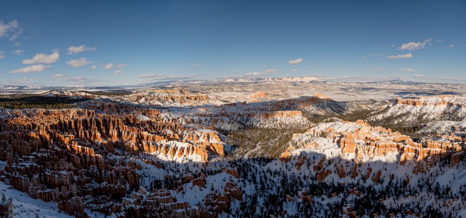
Bryce Canyon National Park, in southern Utah, isn’t really a canyon at all but a series of giant natural amphitheaters carved into the edge of the Paunsaugunt Plateau. They are filled with thousands of hoodoos: slender spires of orange, pink and white limestone shaped by frost and rain. From viewpoints such as Sunrise, Sunset, Inspiration and Bryce points you look down on this stone forest, and short, steep trails take you down among the formations. At nearly 8,000 ft (2,400 m) and more, Bryce is far cooler than nearby Zion, with snow on the hoodoos in winter and some of the darkest night skies in the country. It is a compact park: the main road runs 18 miles (29 km) to Rainbow Point, and the famous Bryce Amphitheater lies along its first 3 miles (4.8 km), so even a single day here is rewarding.
Right now in Bryce Canyon National Park (Bryce Canyon)
- Thu10–21°C50–70°FPartly cloudy
- Fri9–21°C49–70°FPartly cloudy
- Sat10–17°C50–62°F5 mm rain
- Mon 12 Oct Columbus Day · regional holiday in Utah
Top tours in Bryce Canyon National Park
See all tours for Bryce Canyon National Park →
From local operators, with prices and reviews; you check availability and book on Viator, our partner. We may earn a commission at no extra cost to you. How we earn money
Bryce Canyon at a glance
- Best months: May–June and September–early October, for mild days and open trails. July and August bring afternoon thunderstorms; from October to May nights drop below freezing.
- Time needed: one full day for the viewpoints and the Queen’s Garden and Navajo trails; two days to add a longer hike, the scenic drive to Rainbow Point and a night-sky program.
- Getting there: about 85 miles (137 km) from Zion, 80 miles (129 km) from Cedar City’s airport and about 270 miles (435 km) from both Las Vegas and Salt Lake City. There is no public transport to the park.
- Fees (as of October 2026): $35 per car for 7 days, plus $100 per person for non-US residents aged 16 and over without an annual or America the Beautiful pass. Cards only; no entry reservation needed.
- Before you go: entry rules for international visitors (ESTA or visa), driving and tipping are in our United States travel guide.
Entrance fees and passes (as of October 2026)
The park is open 24 hours a day, all year, and no reservation is needed to enter. Bryce Canyon is cashless: pay by card at the entrance station or the shuttle station, or buy a digital pass on Recreation.gov before you arrive and show it on your phone.
| Pass | Price | What it covers |
|---|---|---|
| Private vehicle | $35 | One non-commercial vehicle (up to 15 seats) and its passengers, 7 days, including the shuttle |
| Motorcycle | $30 | Up to 2 motorcycles, 4 riders, 7 days |
| Per person (foot or bike) | $20 | Each person 16 or over; under-16s free; 7 days |
| Non-resident fee | +$100 per person | Non-US residents 16 and over, unless entering with an annual or America the Beautiful pass; also charged on commercial tours |
| Bryce Canyon annual pass | $70 | This park, 12 months; US citizens and residents |
| America the Beautiful pass | $80 residents / $250 non-residents | All national parks and federal recreation lands for 12 months; one vehicle or four people paying per person |
For international visitors: Bryce Canyon is one of the parks that charge the $100 non-resident fee, and so is Zion. If you are visiting both, a single $250 non-resident America the Beautiful pass covers the car and waives the fee for the holder and up to three other adults, and is also valid at Arches and the Grand Canyon. US seniors 62 and over can buy a $20 annual or $80 lifetime pass, and US military, US 4th graders and US residents with a permanent disability travel free. US citizens and residents enter free on the remaining 2026 fee-free days, 27 October and 11 November.
The free Bryce Canyon shuttle
From spring to mid-October a free shuttle loops through the Bryce Amphitheater, stopping at the four most famous viewpoints, the Visitor Center, the lodge and the campgrounds. Riding is not compulsory, but viewpoint parking lots fill and are sometimes closed temporarily, so it is the easiest way to visit and perfect for one-way hikes along the rim. Your entrance pass covers everyone in your vehicle; show it to the driver if you board outside the park.
| 2026 dates | Hours |
|---|---|
| 3 April to 8 May | 8 a.m. to 6 p.m. |
| 9 May to 20 September | 8 a.m. to 8 p.m. |
| 21 September to 18 October | 8 a.m. to 6 p.m. |
Buses come about every 15 minutes, and a full loop takes about 50 minutes; an online Shuttle Tracker shows where the next bus is. The best place to start is the Shuttle Station in Bryce Canyon City (stop 1), just north of the park, with free all-day parking and a booth selling passes; or park in the overflow lot opposite the Visitor Center (stop 6), whose own lot has a one-hour limit. Buses are wheelchair accessible and carry two bikes; pets are not allowed. Vehicles longer than 23 ft (7 m) can’t park in the Bryce Amphitheater during shuttle hours. The three-hour Rainbow bus tour to the far end of the park is not running, so drive there yourself. The 2027 shuttle dates had not been announced in early October 2026; in recent years the season has run from about April to mid-October.
Top things to see at Bryce Canyon
Sunrise Point and Sunset Point
These neighboring viewpoints on the rim of the Bryce Amphitheater are the heart of the park and the start of its most popular trails. The paved half-mile (0.8 km) of the Rim Trail between them is the easiest walk in the park, with constant views over the hoodoos, and the only trail open to leashed pets. Despite the names, both are lovely at sunrise, when the first light turns the spires glowing orange.
Inspiration Point and Bryce Point
Inspiration Point has three levels of overlook, each higher and wider than the last, with a view straight down into the densest crowd of hoodoos, the so-called Silent City. Bryce Point, at the southern end of the amphitheater, looks back across the whole bowl and is a classic sunrise spot; it is also the trailhead for the Peekaboo Loop.
The scenic drive to Rainbow Point
Beyond the amphitheater, the park road climbs south through pine and fir forest to Rainbow and Yovimpa points at 9,115 ft (2,778 m), with views across the Grand Staircase toward Arizona. Stop at viewpoints such as Farview, Natural Bridge (a large arch in the rim) and Agua Canyon on the way back, since they are all on the right-hand side when driving north. At the end of the road, the 1-mile (1.6 km) Bristlecone Loop passes ancient bristlecone pines.
Mossy Cave
In the north of the park, 4 miles (6.4 km) east of the turnoff on Highway 12 and outside the main entrance, a short streamside walk of 0.8 miles (1.3 km) round trip leads to a mossy grotto, hung with icicles in winter, and a small waterfall. The trail has become very crowded: the park advises avoiding it between 10 a.m. and 6 p.m., and cars parked outside the lot may be ticketed or towed.
Viewpoints
- Bryce Amphitheater
- Bryce Point
- Rainbow Point
- Sunrise Point
- Sunset Point
Nature
- Navajo Loop Trail
Peaks and mountains
- Inspiration Point
Hiking among the hoodoos
Every trail into the amphitheater starts by going down, so the hard part is the climb back up at high altitude. Wear real hiking shoes with good tread: the park says unsuitable footwear is the number one cause of its rescues and hospital trips. Stay on the trails and never climb the hoodoos, whose crumbly rock is dangerous and protected. See our hiking guide for general advice.
| Trail | Start | Distance (round trip) | Climb | Notes |
|---|---|---|---|---|
| Queen’s Garden | Sunrise Point | 1.8 miles (2.9 km) | 450 ft (137 m) | The gentlest way down; spur to the Queen Victoria hoodoo |
| Navajo Loop (Two Bridges side) | Sunset Point | 1.3 miles (2.2 km) | 515 ft (157 m) | Thor’s Hammer and Two Bridges; steep switchbacks |
| Queen’s Garden and Navajo combination | Sunrise or Sunset Point | 2.9 miles (4.6 km) | 625 ft (191 m) | The park’s most popular hike; 2–3 hours |
| Peekaboo Loop | Bryce Point | 5.5 miles (8.8 km) | 1,560 ft (474 m) | Steep and spectacular; Wall of Windows; clockwise only, shared with horses |
| Fairyland Loop | Fairyland Point | 8 miles (12.9 km) | 1,900 ft (579 m) | Quieter; Chinese Wall and Tower Bridge; 4–5 hours |
| Rim Trail | Any viewpoint | 1–11 miles (1.6–17.7 km) one way | Up to 719 ft (219 m) | Fairyland Point to Bryce Point along the edge; use the shuttle to return |
Closed in autumn 2026: after a storm in late August, the Wall Street section of the Navajo Loop and the Bryce Connector Trail to the Peekaboo Loop have been closed until further notice. Use the Two Bridges side of the Navajo Loop, which the park also recommends in winter, and check the alerts at the Visitor Center before you hike. The long Under-the-Rim backcountry trail has badly worn sections and needs strong navigation skills. In winter, bring traction devices for icy trails, and try snowshoeing or cross-country skiing on the rim.
Altitude, lightning and cold
The Visitor Center stands at 7,894 ft (2,406 m) and Rainbow Point at 9,115 ft (2,778 m), where there is only about 70% of the oxygen you may be used to at sea level. Take it slowly, turn back before you are tired, and drink about a quart (1 liter) of water every one to two hours on the trail. Lightning is a danger all year and especially in the July–August thunderstorms: if you hear thunder, lightning is within 10 miles (16 km), so get into a building or vehicle and keep off exposed rims. The heat is rarely extreme here, but sun at altitude burns quickly. From October to May temperatures fall below freezing almost every night, and October snowstorms are not unusual; roads are plowed but may close briefly during storms.
Other things to do at Bryce Canyon
- Stargazing: Bryce is one of the darkest places in the country, with thousands of stars and the Milky Way from horizon to horizon on moonless nights. Astronomy rangers give about 100 programs a year, there is a four-day Astronomy Festival every summer, and ticketed full-moon hikes of 1–2 miles (1.6–3.2 km).
- Horse and mule rides: Canyon Trail Rides, the park’s concessioner, runs 2- and 3-hour guided rides into the amphitheater and along the Peekaboo Loop, usually from April to 31 October, weather permitting.
- Cycling: a paved shared-use path runs from Bryce Canyon City into the park; bikes are not allowed on the hiking trails. See our cycling guide.
- Ranger programs: geology talks, rim walks and evening programs run in the busy season; check the schedule at the Visitor Center.
Getting there
The park entrance is on State Route 63, 3 miles (5 km) south of Highway 12; the Visitor Center is 1 mile (1.6 km) inside the boundary. There is no public transport, so you need a car or a tour; driving tips are in our United States travel guide.
| From | Distance | Route and time |
|---|---|---|
| Zion National Park (Zion Canyon) | about 85 miles (137 km) | State Route 9 through the Zion-Mt. Carmel Tunnel, US 89 and Highway 12; about 1.75 hours. Large RVs must avoid the tunnel: about 150 miles (241 km) via Highway 20, 2.5 hours |
| Cedar City, UT (CDC airport) | 80 miles (129 km) | State Route 14 over the mountains, US 89 and Highway 12; about 1.75 hours |
| St. George, UT (SGU airport) | 125 miles (201 km) | Interstate 15 and the Zion or Highway 20 routes; about 2.5 hours |
| Las Vegas, NV (LAS airport) | about 270 miles (435 km) | Interstate 15 north; about 4 hours |
| Salt Lake City, UT (SLC airport) | about 270 miles (435 km) | Interstate 15 south, Highway 20 and US 89; about 4 hours |
Many visitors fly into Las Vegas (see our Las Vegas travel guide) and drive a loop through Zion, Bryce Canyon, Capitol Reef and Arches, or south to the Grand Canyon‘s North Rim. The Zion tunnel has strict size limits: vehicles longer than 35 ft 9 in (10.9 m), wider than 7 ft 10 in (2.39 m) or taller than 11 ft 4 in (3.45 m) must go around.
Around Bryce Canyon
- Red Canyon: bright red hoodoos and a paved bike path along Highway 12, about 13 miles (21 km) west, in Dixie National Forest; dogs are welcome on its trails.
- Scenic Byway 12: one of America’s great drives, east through Tropic, Escalante and the Grand Staircase-Escalante National Monument to Boulder and Capitol Reef National Park.
- Kodachrome Basin State Park: colorful sandstone chimneys about 20 miles (32 km) southeast, with its own entrance fee.
- Zion National Park: deep red canyons, Angels Landing and The Narrows, about two hours southwest.
Nearby destinations
- Zion National Park87 km
- Grand Canyon National Park176 km
- Monument Valley197 km
- Moab252 km
- Arches National Park260 km
When to go and how long to stay
Bryce has a mountain climate. Summer days are pleasant, from the high 60s to low 70s °F (about 20–22 °C) in June to around 80 °F (27 °C) in July, with frequent short afternoon storms in July and August. Autumn is crisp and clear; winter brings snow on red rock, the quietest trails and bitter nights; spring is changeable, with heavy snow possible into April. The busiest months are May to September.
| Season | Average high | Average low | What it’s like |
|---|---|---|---|
| Spring (Mar–May) | 46–63 °F (8–17 °C) | 23–37 °F (−5 to 3 °C) | Snow possible into April; muddy trails; quieter. |
| Summer (Jun–Aug) | 75–80 °F (24–27 °C) | 45–52 °F (7–11 °C) | Busiest; afternoon thunderstorms and lightning in July and August. |
| Autumn (Sep–Nov) | 70–46 °F (21–8 °C) | 42–23 °F (5 to −5 °C) | Clear and crisp; first snow often in October. |
| Winter (Dec–Feb) | 37–39 °F (3–4 °C) | 17–18 °F (−8 °C) | Snowy hoodoos, icy trails, very cold nights. |
Figures are NOAA 1991–2020 normals for the Bryce Canyon park headquarters station at 7,890 ft (2,405 m). It gets about 16.7 inches (423 mm) of precipitation a year and about 87 inches (2.2 m) of snow, most from November to March.
Weather month by month
Bryce Canyon in one day
Watch sunrise from Sunrise or Bryce Point, then hike down the Queen’s Garden Trail and back up the Navajo Loop to Sunset Point. After lunch, drive to Rainbow Point and stop at the viewpoints on the way back, and finish with sunset at Inspiration Point.
Two days
Add the Peekaboo Loop or the Fairyland Loop in the cool of the morning, a horse ride or a ranger program, and an evening astronomy program on a moonless night. Then continue east on Scenic Byway 12 or west to Zion.
Where to stay near Bryce Canyon
- The Lodge at Bryce Canyon: the historic lodge inside the park, a short walk from the rim, with 114 rooms in the lodge, motel buildings and cabins, a dining room and gift shop. It is seasonal; book well ahead.
- Bryce Canyon City: just outside the entrance, with large hotels, shops and the shuttle station; the most convenient base.
- Tropic and Panguitch: smaller, quieter towns 11 miles (18 km) east and 24 miles (39 km) northwest.
- Camping: North Campground is open all year and books up to 6 months ahead; Sunset Campground closes in winter and books 14 days ahead. Sites cost $30 a night (half price with a senior or access pass) and can fill by noon on weekends from May to October.
Room taxes: Utah room rates are quoted before tax. Hotels in Garfield County add state and local sales tax and transient room taxes (the county’s room tax rose to 4.5% in October 2025), together roughly 12–14% of the room rate; check the total when you book.
Practical tips for Bryce Canyon
- Arrive early or use the shuttle: viewpoint lots fill from mid-morning in summer.
- Fuel and food: there is a general store near Sunrise Point and the lodge dining room in season; the nearest fuel outside the park is in Bryce Canyon City.
- Wildlife: never feed prairie dogs, squirrels or chipmunks; rodents can carry diseases such as plague.
- Pets are allowed only on paved surfaces: roads, campgrounds, viewpoints, the shared-use path and the Rim Trail between Sunset and Sunrise points.
- Fires: only in campground fire pits; fireworks are always banned. Drones are not allowed in national parks.
- Time zone: Utah uses Mountain Time with daylight saving time, one hour ahead of Las Vegas all year and one hour ahead of Arizona in summer. Emergencies: call 911.
What to pack for Bryce Canyon
Pack warm layers in every season (summer mornings can be near freezing), hiking boots with ankle support and good tread, a sun hat, sunglasses and high-factor sunscreen for the strong mountain sun, a refillable water bottle, a rain jacket for summer storms and a headlamp for stargazing. From October to May, add a warm coat, hat, gloves and traction devices for icy trails.
Bryce Canyon travel FAQ
How much does it cost to enter Bryce Canyon in 2026?
$35 per car, $30 per motorcycle or $20 per person, valid 7 days. Non-US residents aged 16 and over also pay $100 each unless they have an annual or America the Beautiful pass ($250 for non-residents). The park only takes cards.
Do I need a reservation to visit Bryce Canyon?
No. There is no timed entry. Book the lodge, campsites, horse rides and full-moon hikes ahead.
When does the Bryce Canyon shuttle run?
In 2026, from 3 April to 18 October, usually from 8 a.m. to 6 p.m. (to 8 p.m. in summer), every 15 minutes or so. It is free with your entrance pass and optional.
What is the best hike in Bryce Canyon?
The Queen’s Garden and Navajo combination, a 2.9-mile (4.6 km) loop of 2–3 hours. In autumn 2026, Wall Street is closed, so use the Two Bridges side of the Navajo Loop.
Is Wall Street open at Bryce Canyon?
Not as of October 2026. Wall Street and the Bryce Connector Trail have been closed since late August 2026 after a storm, until further notice.
How far is Bryce Canyon from Zion?
About 85 miles (137 km), roughly 1.75 hours through the Zion-Mt. Carmel Tunnel. Larger vehicles that can’t use the tunnel drive about 150 miles (241 km) via Highway 20.
Is Bryce Canyon open in winter?
Yes, 24 hours a day all year. Roads are plowed after storms but can close briefly, Sunset Campground and the shuttle close, and trails can be icy.
When is the best time to see the stars at Bryce Canyon?
On moonless nights, during the week of the new moon or the week before. Astronomy rangers run about 100 programs a year.
Plan your trip
Partner links: TravelerCenter may earn a commission if you book, at no extra cost to you.
Sources · last reviewed 4 October 2026
Researched and last reviewed on 4 October 2026. Fees, passes and fee-free days, the 2026 shuttle schedule, trail distances and closures, safety, weather, campgrounds, lodging, horse rides, astronomy programs, distances and airports come from Bryce Canyon National Park (National Park Service); climate from NOAA’s 1991–2020 normals for the park headquarters station. Garfield County room taxes, drive times and some nearby places are flagged for checking. Conditions and rules change, so check the park’s alerts before you travel. For entry rules, driving and tipping, see our United States travel guide.
Also: NOAA NCEI normals 1991–2020, Bryce Canyon National Park Headquarters (climate)
Data: Weather: MET Norway (CC BY 4.0) · Rates: ECB · Holidays: Nager.Date · Costs: World Bank ICP and price levels · © OpenStreetMap contributors (ODBL) · Wikidata (CC0)