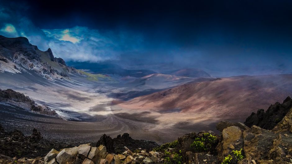
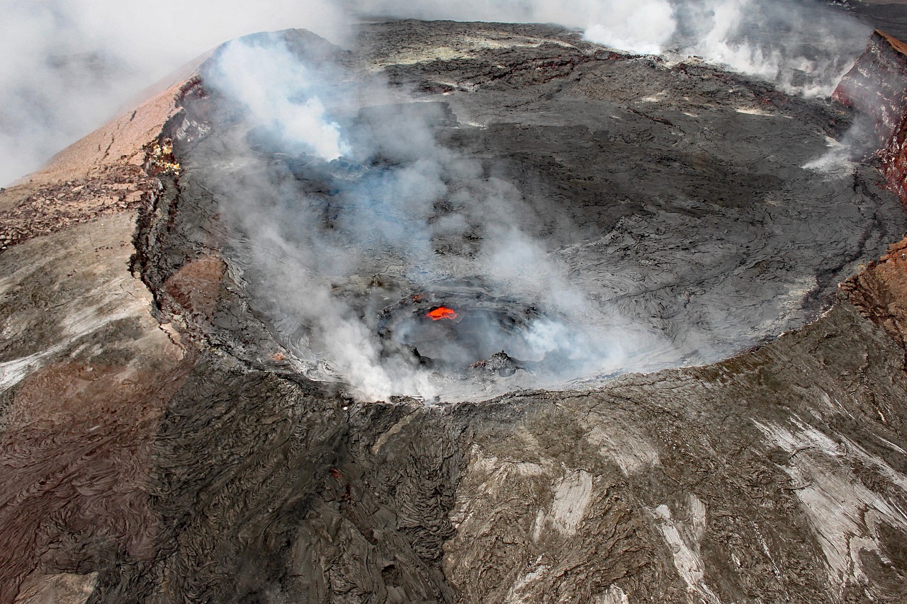
Hawaiʻi Volcanoes National Park, on the southeast side of Hawaiʻi Island, protects the summits of two of the world’s most active volcanoes, Kīlauea and Mauna Loa, from sea level to 13,680 feet (4,170 m). It is a UNESCO World Heritage Site and an International Biosphere Reserve, and a place of deep cultural importance to Native Hawaiians as the home of Pele, goddess of volcanoes. Since 23 December 2024, Kīlauea has been erupting in episodes inside Halemaʻumaʻu crater, with lava fountains that last a few hours, sometimes hundreds of feet high, separated by pauses of days or weeks. All of it has stayed within a closed area of the park, and on a good night you can watch the glow from safe overlooks on the caldera rim. Beyond the summit, Chain of Craters Road drops 18.8 miles (30.3 km) past craters and lava flows to the sea, and the quiet Kahuku Unit offers ranch-country hikes on Mauna Loa’s slopes. The summit is also in the last stage of a two-year rebuilding project, so expect busy parking and a temporary visitor center.
Right now in Hawaii Volcanoes National Park (Kīlauea Visitor Center)
- Wed15–21°C59–69°FMostly clear
- Thu16–19°C60–67°F12 mm rain
- Fri17–19°C63–67°F16 mm rain
- Mon 12 Oct Columbus Day
- Mon 12 Oct Indigenous Peoples' Day · regional holiday in Hawaii
Top tours in Hawaii Volcanoes National Park
See all tours for Hawaii Volcanoes National Park →
From local operators, with prices and reviews; you check availability and book on Viator, our partner. We may earn a commission at no extra cost to you. How we earn money
Hawaii Volcanoes at a glance
- Best months: any time; April to June and September to October are a little less crowded. The summit, at about 4,000 feet (1,200 m), is cool and often rainy all year, while the coast is hot and dry.
- Time needed: one full day for the summit, Kīlauea Iki and Chain of Craters Road; two or three days to see the eruption at night, hike more and visit Kahuku.
- Getting there: 30 miles (48 km) from Hilo, about 45 minutes; 95 miles (153 km) from Kailua-Kona, about 2–2.5 hours. There is no public shuttle inside the park.
- Fees (as of October 2026): $30 per car for 7 days; no $100 non-resident fee and no entry reservation. The $55 Tri-Park pass also covers Haleakalā and Puʻuhonua o Hōnaunau.
- Before you go: entry rules for international visitors (ESTA or visa), driving and tipping are in our United States travel guide.
Entrance fees and passes (as of October 2026)
All visitors need an entrance pass, bought at the entrance station by card or online as a digital pass on Recreation.gov; if the entrance station is unstaffed when you arrive, buy a pass online or pay on a later entry. The park is open 24 hours a day, every day of the year.
| Pass | Price | What it covers |
|---|---|---|
| Private vehicle | $30 | One non-commercial vehicle (15 seats or fewer) and everyone in it, 7 days |
| Motorcycle | $25 | Up to 2 motorcycles with 4 riders, 7 days |
| Per person (foot or bike) | $15 | Each person 16 or over; under-16s free; 7 days |
| Hawaiʻi Tri-Park annual pass | $55 | Hawaiʻi Volcanoes, Haleakalā and Puʻuhonua o Hōnaunau, 12 months |
| America the Beautiful pass | $80 US residents / $250 non-residents | All national parks and federal recreation lands for 12 months; one vehicle or four people paying per person |
| Commercial tours | $15 per person to $200 per vehicle | Depends on vehicle size or type of guided tour |
For international visitors: Hawaiʻi Volcanoes is not one of the 11 national parks that charge non-US residents an extra $100 per person in 2026, so visitors from abroad pay the same $30 per car as Americans. The $250 non-resident America the Beautiful pass is worth buying only if you also plan to visit mainland parks such as Yosemite, Grand Canyon or Yellowstone, where it waives the $100 fee for the pass holder and up to three other adults. If your trip covers only Hawaiʻi, the $55 Tri-Park pass, valid for 12 months, pays for itself if you visit both this park and Haleakalā on Maui. US seniors 62 and over can buy a $20 annual or $80 lifetime pass, and US citizens and residents enter free on the remaining 2026 fee-free days, 27 October and 11 November.
Kīlauea’s eruption: status in October 2026
According to the US Geological Survey’s Hawaiian Volcano Observatory (HVO), Kīlauea has been erupting episodically since 23 December 2024 from vents in Halemaʻumaʻu, the crater within Kaluapele, Kīlauea’s summit caldera. By early October 2026 there had been 54 lava-fountaining episodes, each usually lasting less than 12 hours, separated by pauses of two weeks or more. The latest, episode 54 on 25 August 2026, lasted 9 hours, with fountains from the north vent reaching about 500 feet (150 m).
In HVO’s daily update of 3 October 2026, the volcano alert level was WATCH and the aviation color code ORANGE. Strong glow and flames were visible from the vents at night, but no lava was overflowing. A small intrusion of magma beneath the summit caldera on 30 September and 1 October had not resumed; HVO said a 55th episode remained possible but could no longer be forecast, and that lava could also break out in a new spot within the caldera with little warning. There was no unusual activity on Kīlauea’s East or Southwest Rift Zones, and no threat to homes or park buildings. Mauna Loa, the park’s other volcano, was at the normal level (aviation code green) in HVO’s monthly update of 1 October 2026, with slow inflation as magma refills its reservoir since the 2022 eruption.
How to watch: before you drive up, check the USGS webcams and HVO’s daily update to see whether an episode is under way or the volcano is in a pause. During an episode you may see lava fountains and flowing lava; during a pause, at best a faint glow at night. The National Park Service recommends the overlooks along Crater Rim Drive West, the Welcome Center area, Kīlauea Overlook and Uēkahuna, which usually have more parking, and suggests using Crater Rim Drive East for Kīlauea Iki, Nāhuku and Chain of Craters Road. Stay behind rope lines: the closed area around the vents has volcanic gas, unstable cliff edges, ground cracks and falling tephra.
Volcanic hazards, vog and air quality
The park is a live volcanic landscape, and a few precautions keep visits safe:
- Volcanic gas and vog: the summit releases sulfur dioxide (SO₂), typically 1,000–5,000 tonnes a day even between episodes, which forms vog (volcanic smog) downwind. People with heart or breathing problems, pregnant women, infants and young children are most sensitive. Check the park’s air quality page during your visit and leave areas where the air feels harsh.
- Tephra and Pele’s hair: lava fountains throw out glassy fragments, ash and fine strands called Pele’s hair, mostly into the closed area but sometimes carried by wind. They irritate eyes, skin and lungs; wear long sleeves and eye protection near falling tephra, and consider a dust mask.
- Cliffs and cracks: stay on trails and behind barriers; crater edges can collapse without warning.
- Lava and hot ground: old flows have sharp, glassy surfaces that cut skin; wear closed shoes and long pants, and carry plenty of water on the hot coastal flows.
- Earthquakes: the summit has frequent small earthquakes; follow ranger instructions if areas close.
Drones are prohibited in the park without written approval. Watch for nēnē, the endangered Hawaiian goose, on roads and in parking lots: cars are the leading cause of adult nēnē deaths in the park, so drive slowly and never feed them.
Construction at the summit in 2026
The 2018 summit collapse and earthquakes badly damaged buildings and roads at Kīlauea’s summit, and a two-year repair project that began in January 2024 is due to finish in late 2026. While Kīlauea Visitor Center is closed for a full renovation, a temporary Welcome Center with rangers, maps and the park store operates at Kilauea Military Camp, 1.25 miles (2 km) past the entrance station on the right, from 9 a.m. to 4:45 p.m. daily; park at the nearby ball field. The earthquake-damaged Jaggar Museum and old observatory buildings at Uēkahuna have been removed and will not be rebuilt; the overlook there has been restored as a quieter, culturally respectful viewing area. Vehicles longer than 25 feet (7.6 m) or wider than 8 feet (2.4 m) cannot drive past Kilauea Military Camp to Uēkahuna. Expect delays, reduced parking and occasional closures of Tree Molds Road.
Top things to see in Hawaii Volcanoes
Crater Rim Drive and the summit overlooks
Start at the Welcome Center, then follow Crater Rim Drive. To the west, Uēkahuna and Kīlauea Overlook look across the vast caldera to Halemaʻumaʻu. Nearby, the Steam Vents and Sulphur Banks (Haʻakulamanu) show steam rising through cracks and yellow crystals left by volcanic gases. All park roads are paved two-wheel-drive roads. Parking lots often fill by 10 a.m., especially in December, January, June and July and whenever lava is erupting; arrive early or late and have a backup plan.
Kīlauea Iki Trail
One of the park’s finest hikes descends 400 feet (122 m) through rainforest to the floor of Kīlauea Iki, a crater whose lava lake from 1959 is still steaming in places, then crosses the hardened crust and climbs back to the rim. It takes most people two to three hours; combine it with Nāhuku.
Nāhuku (Thurston Lava Tube)
A short walk through lush rainforest leads into a cave where a river of lava flowed about 500 years ago. It is one of the busiest stops, with limited parking; come early in the morning or late in the afternoon.
Devastation Trail
A paved path through a landscape buried by falling cinder in the 1959 Kīlauea Iki eruption, now slowly recovering, with views of Puʻupuaʻi cinder cone.
Chain of Craters Road to the sea
This 18.8-mile (30.3 km) road drops about 3,700 feet (1,130 m) from the summit to the coast, past pit craters, the 1969–1974 Maunaulu lava flows and wide views over the Hōlei Pali. Near the bottom, a boardwalk crosses a lava field to Puʻuloa, the largest group of petroglyphs in Hawaiʻi, and at the end of the road you can see the Hōlei Sea Arch. Lava from the Puʻuʻōʻō eruption covered nearly 9 miles (14.5 km) of the old road to Kalapana between 1983 and 2018, which is why it now ends at a barrier. There is no food, water or fuel on the road; vault toilets are at Maunaulu and the end of the road, and the only emergency phone is at the Puʻuloa trailhead. Allow at least 2.5 hours for the round trip with stops.
The Kahuku Unit
On the southern flank of Mauna Loa, about an hour’s drive west of the summit near mile marker 70.5 on Highway 11, Kahuku was one of the largest cattle ranches in Hawaiʻi for more than 150 years. Its 116,000 acres of pasture, forest and lava flows are quieter than Kīlauea. Kahuku is open Thursday to Sunday, 8 a.m. to 4 p.m., and has no drinking water. Short hikes include the Puʻu o Lokuana cinder cone (a 0.4-mile / 0.6 km loop with 130 feet / 40 m of climbing), the Palm Trail (a 2.6-mile / 4.2 km loop along the 1868 fissure) and longer trails to forested pit craters, where hikers must clean their shoes at the decontamination gate to help stop the spread of Rapid ʻŌhiʻa Death, a fungal disease killing native trees.
Mauna Loa Road
A narrow road climbs from Highway 11 near the park entrance through native forest, past the Kīpukapuaulu bird loop, to a lookout at about 6,660 feet (2,030 m). It is the start of the strenuous, multi-day trail to Mauna Loa’s summit, which requires a backcountry permit and is only for well-equipped, acclimatized hikers.
Nature
- Chain of Craters Road
- Devastation Trail
- Halemaʻumaʻu Crater
- Hōlei sea arch
- Kīlauea Iki
Peaks and mountains
- Kīlauea
- Mauna Loa
Other things to do in Hawaii Volcanoes
- Day hikes: the Crater Rim Trail, Kīlauea Iki, the Puʻuhuluhulu cinder cone at Maunaulu, the Kaʻū Desert footprints trail and the Kīpukapuaulu forest loop. See our hiking guide.
- Ranger programs: talks and guided walks are listed daily at the Welcome Center and on the park calendar.
- Volcano Art Center: a gallery in the historic 1877 Volcano House building near the old visitor center, with local art.
- Night viewing: when an eruption episode is under way, the glow from the caldera overlooks is spectacular after dark; bring a headlamp and warm clothes.
- Backcountry: wilderness camping and the Mauna Loa summit trail need permits from the park.
- Cycling: bikes are allowed on paved roads; ride carefully, as roads are narrow and busy. See our cycling guide.
Activities and best months
- LandChain of Craters Road runs 18.8 miles (30.3 km) from the summit to the sea, with no food, water or fuel; about 9 miles of the old road lie under lava.
Getting there
The park entrance is on Highway 11 between Hilo and Kona, next to the village of Volcano. Rental cars are the norm and can be picked up at both Hilo and Kona airports. Hawaiʻi County’s Hele-On bus stops near Volcano House and Kīlauea Visitor Center, but schedules change and there is no transport inside the park, and rideshare drivers are very hard to find this far from town.
| From | Distance | Route and time |
|---|---|---|
| Hilo (ITO airport) | 30 miles (48 km) | Highway 11 southwest; about 45 minutes |
| Kailua-Kona | 95 miles (153 km) | Highway 11 south via Kaʻū; about 2–2.5 hours |
| Kailua-Kona via Waimea and Hilo | 125 miles (201 km) | Highways 19 and 11; about 2.5–3 hours |
| Waikoloa resorts | about 90 miles (145 km) | Via Highway 200 (Saddle Road) and Hilo; about 2 hours |
| Kona airport (KOA) | about 100 miles (161 km) | Highway 11 south; about 2.5 hours |
Hilo International Airport has inter-island flights from Honolulu; Ellison Onizuka Kona International Airport also has nonstop flights from the US mainland. See our Hawaii Island guide for the rest of the island; for Oʻahu and Maui, see the Honolulu and Maui guides.
Around Hawaii Volcanoes
- Volcano Village: rainforest village by the entrance with B&Bs, cabins, cafés and a winery.
- Hilo: a laid-back town with a farmers market, ʻAkaka Falls and Rainbow Falls nearby.
- Punaluʻu Black Sand Beach: about 30 miles (48 km) southwest, where green sea turtles often rest on the sand; keep your distance.
- Puʻuhonua o Hōnaunau National Historical Park: a restored place of refuge on the Kona coast, covered by the Tri-Park pass.
Nearby destinations
- Hawaii Island39 km
- Maui194 km
When to go and how long to stay
The summit of Kīlauea is high, cool and wet. The National Park Service says temperatures there are 12 to 15 °F cooler than at sea level and can be rainy and chilly any day of the year, while the coastal plain at the end of Chain of Craters Road is often hot, dry and windy. Mauna Loa’s summit can have snow in any season. The table uses NOAA’s 1991–2020 climate normals for the park headquarters weather station at about 3,970 feet (1,210 m).
| Season | Average high | Average low | What it’s like |
|---|---|---|---|
| Winter (Dec–Feb) | 68 °F (20 °C) | 49–52 °F (9–11 °C) | Cool, wet and misty; cold nights; busiest in late December and January |
| Spring (Mar–May) | 68–71 °F (20–22 °C) | 51–53 °F (11–12 °C) | Rainy March and April, drying in May |
| Summer (Jun–Aug) | 71–74 °F (22–23 °C) | 54–56 °F (12–13 °C) | Mildest, with frequent showers; busy in June and July |
| Fall (Sep–Nov) | 73 °F falling to 70 °F (23 to 21 °C) | 55–54 °F (13–12 °C) | Pleasant until November rains; fewer crowds |
The station records about 96 inches (2,444 mm) of rain a year, falling on about 160 days, with the wettest months from October to April. Evenings at the caldera rim are often 50 °F (10 °C) or colder, with wind and fog. The Central Pacific hurricane season runs from 1 June to 30 November; storms in 2026 brought fallen trees to some state parks on Hawaiʻi Island, so check the park’s alerts before you go.
Weather month by month
Hawaii Volcanoes in one day
Arrive by 8 a.m., stop at the Welcome Center, then walk the Kīlauea Iki Trail and Nāhuku before the crowds. In the afternoon, drive Chain of Craters Road to Puʻuloa and the Hōlei Sea Arch. Return to the summit for sunset and, if an episode is under way or glow is visible, watch from Kīlauea Overlook or Uēkahuna after dark.
Two or three days
Stay in Volcano Village or at Volcano House. Add the Steam Vents and Sulphur Banks, the Devastation Trail, Mauna Loa Road and Kīpukapuaulu, and a morning at Kahuku (Thursday to Sunday). Use a free evening to return to the caldera rim for the glow, and continue to Punaluʻu and the Kona coast on your last day.
Where to stay near Hawaii Volcanoes
- Volcano House: the only hotel inside the park, on the rim of the caldera facing Halemaʻumaʻu, with 33 rooms, a restaurant, lounge and gift shop. It also manages 10 camper cabins and campsites at Nāmakanipaio Campground nearby. Book well ahead.
- Volcano Village: many vacation rentals and B&Bs just outside the park entrance, often among tree ferns in the rainforest.
- Hilo: hotels 45 minutes away, with more restaurants and shops.
- Camping: Nāmakanipaio and Kulanaokuaiki campgrounds in the park; backcountry sites with permits.
Room taxes: room rates in Hawaiʻi are quoted before tax. Since 1 January 2026, under Act 96 of 2025, the state transient accommodations tax (TAT) is 11%, up from 10.25%. Hawaiʻi County adds its own 3% transient accommodations tax, and hotels usually pass on the general excise tax at up to 4.712%, so expect about 18.7% on top of the room rate. Under the Federal Trade Commission’s fees rule in force since May 2025, mandatory resort or service fees must be included in the advertised total price.
Practical tips for Hawaii Volcanoes
- Check before you go: the HVO daily update, the USGS webcams and the park’s alerts page for closures, air quality and eruption viewing advice.
- Arrive early or late: parking lots fill by mid-morning, especially during eruption episodes; park only in marked spaces, or you may be towed.
- Fuel and food: there is no gas in the park; fill up in Hilo, Volcano Village or Kona, and bring snacks and water, especially for Chain of Craters Road.
- Respect the place: Kīlauea is sacred to Native Hawaiians; watch quietly, do not take lava rocks or leave offerings that are not yours to leave, and do not throw anything into craters.
- Time zone: Hawaiʻi Standard Time (UTC−10), no daylight saving time.
- Phone signal is limited along Chain of Craters Road. Emergencies: call 911.
What to pack for Hawaii Volcanoes
Pack layers: a warm fleece or jacket and a waterproof shell for the cool, wet summit, plus a hat, sunglasses and sunscreen for the exposed lava flows on the coast. Wear sturdy closed shoes and long pants for sharp lava, and bring a headlamp with spare batteries for night viewing, a reusable water bottle and snacks, binoculars, and a dust mask and eye protection if tephra is falling. People sensitive to vog should bring their usual medication.
Hawaii Volcanoes travel FAQ
How much does it cost to enter Hawaiʻi Volcanoes National Park in 2026?
$30 per car, $25 per motorcycle or $15 per person on foot or bike, valid for 7 days. The $55 Tri-Park annual pass also covers Haleakalā and Puʻuhonua o Hōnaunau.
Do international visitors pay the $100 non-resident fee at Hawaiʻi Volcanoes?
No. As of October 2026 the $100 fee applies at 11 other national parks, not here; visitors from abroad pay the same $30 per car.
Do I need a reservation to visit?
No. There is no timed entry or reservation for the park; you need reservations only for Volcano House, campsites and backcountry permits.
Is Kīlauea erupting right now?
Kīlauea has been erupting in episodes since 23 December 2024, with 54 fountaining episodes by early October 2026. On 3 October 2026 it was in a pause, with glow at the vents, and the alert level was WATCH (aviation code ORANGE). Check HVO’s daily update and webcams before you go.
Where is the best place to see the lava?
From the overlooks on Crater Rim Drive West, including Kīlauea Overlook and Uēkahuna, and near the Welcome Center. All eruptive activity is inside a closed area, so stay behind rope lines.
Is vog dangerous for visitors?
Volcanic gas can affect people with heart or breathing conditions, pregnant women and young children most. Check the park’s air quality readings and leave areas where the air feels harsh.
Is the Kīlauea Visitor Center open?
Not in 2026. It is closed for renovation; a temporary Welcome Center at Kilauea Military Camp, 1.25 miles past the entrance, is open from 9 a.m. to 4:45 p.m. daily.
How long is Chain of Craters Road?
18.8 miles (30.3 km) from Crater Rim Drive to the end of the road near the Hōlei Sea Arch, with no food, water or fuel. Allow at least 2.5 hours for the round trip.
When is the Kahuku Unit open?
Thursday to Sunday, 8 a.m. to 4 p.m. It is near mile marker 70.5 on Highway 11, about an hour west of the summit.
How far is Hawaiʻi Volcanoes from Kona?
About 95 miles (153 km) on Highway 11, or 2 to 2.5 hours by car. From Hilo it is 30 miles (48 km), about 45 minutes.
Plan your trip
Partner links: TravelerCenter may earn a commission if you book, at no extra cost to you.
Sources · last reviewed 4 October 2026
Researched and last reviewed on 4 October 2026. Fees, hours, directions, the Welcome Center, construction, eruption viewing, Chain of Craters Road, Kahuku, lodging, parking and weather: National Park Service (nps.gov/havo); national park passes and the non-resident fee: National Park Service; Kīlauea eruption status, episode count, alert levels, gas emissions and hazards, and Mauna Loa status: US Geological Survey Hawaiian Volcano Observatory updates of 1 and 3 October 2026; hotel taxes: Hawaiʻi Department of Taxation and Hawaiʻi County; resort fees: Federal Trade Commission; climate: NOAA’s 1991–2020 normals for the Hawaii Volcanoes National Park headquarters station. Chain of Craters Road’s elevation drop, hike times, Mauna Loa Road’s height, the Volcano Art Center and Punaluʻu are general knowledge, flagged for checking. Volcanic conditions change by the hour, so check HVO and the park before you go. For entry rules, money and general safety, see our United States travel guide.
Also: nps.gov · NOAA NCEI normals 1991–2020, Hawaii Volcanoes National Park Headquarters (climate)
Data: Weather: MET Norway (CC BY 4.0) · Sea temperature: NOAA CoastWatch · Air quality: OpenAQ · Rates: ECB · Holidays: Nager.Date · Costs: World Bank ICP and price levels · © OpenStreetMap contributors (ODBL) · Wikidata (CC0)