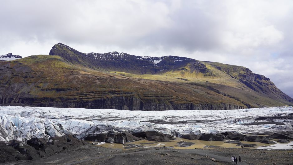
Vatnajökull National Park is Europe’s largest national park, covering roughly 14% of Iceland around the Vatnajökull ice cap, the biggest glacier in Europe outside the Arctic islands. Under the ice lie active volcanoes, and the park’s mix of glaciers, volcanoes, rivers and lava earned it a place on UNESCO’s World Heritage List in 2019. Most visitors know its southern edge along the Ring Road: Skaftafell, with the Svartifoss waterfall and guided glacier hikes, and Jökulsárlón, the lagoon where icebergs float out to sea and wash up on Diamond Beach. In winter, licensed guides lead visitors into blue ice caves. The park also reaches far to the north, where Dettifoss, Europe’s most powerful waterfall, roars through the Jökulsárgljúfur canyon to the horseshoe cliffs of Ásbyrgi. Give the south at least two days and nights; the north fits into a trip around Mývatn and Húsavík.
Right now in Vatnajökull National Park (Skaftafell)
- Wed1–5°C33–41°FPartly cloudy
- Thu1–5°C34–40°F24 mm rain
- Fri4–7°C40–44°F12 mm rain
Top tours in Vatnajökull National Park
See all tours for Vatnajökull National Park →
From local operators, with prices and reviews; you check availability and book on Viator, our partner. We may earn a commission at no extra cost to you. How we earn money
Vatnajökull National Park at a glance
- Best for: glacier hikes and ice caves, the icebergs of Jökulsárlón and Diamond Beach, waterfalls (Svartifoss, Dettifoss), canyon walks and some of Iceland’s wildest landscapes.
- How long: 2–3 days for Skaftafell and Jökulsárlón on a south coast trip; another day for Dettifoss and Ásbyrgi in the north; more for the summer-only highland areas.
- Best time: June to August for hiking, boat trips and the highlands; about November to March for ice caves and the Northern Lights; Jökulsárlón and Diamond Beach are good all year.
- Getting in: Skaftafell is about 330 km (4 hours) east of Reykjavík on the Ring Road, Jökulsárlón about 380 km (5 hours). Dettifoss is about 2 hours from Akureyri and 50 minutes from Mývatn.
- Getting around: a hire car is easiest; otherwise join tours from Reykjavík, Skaftafell, Jökulsárlón or Höfn.
- Budget: as of October 2026, the park’s area fee at Skaftafell and Jökulsárlón is ISK 1,110 a day for a car. Glacier hikes, ice caves and boat tours are the big costs.
The park, area by area
The national park was founded in 2008 by joining Skaftafell and Jökulsárgljúfur national parks with the ice cap and surrounding land, and it has grown since, adding the Jökulsárlón area (Breiðamerkursandur) in 2017. It is run in four regions, each with its own visitor centre.
- South (Skaftafell, Öræfi and Breiðamerkursandur): the area most people visit, along the Ring Road between Kirkjubæjarklaustur and Höfn. It includes Skaftafell, Iceland’s highest peak Hvannadalshnúkur (about 2,110 m) on Öræfajökull, the glacier lagoons of Fjallsárlón and Jökulsárlón, and Diamond Beach.
- North (Jökulsárgljúfur and the highlands north of the ice): Dettifoss, Selfoss and Hafragilsfoss waterfalls, the Hljóðaklettar rock formations, Ásbyrgi canyon, and in summer the Askja caldera and Kverkfjöll.
- East (Snæfell and Lónsöræfi): Iceland’s highest mountain outside the glaciers, Snæfell, reindeer country and remote hiking.
- West (Lakagígar and Eldgjá): the 25 km crater row of Laki, whose 1783–84 eruption caused famine across Iceland, and the Eldgjá fissure, reached on summer-only F-roads.
Top things to see in Vatnajökull National Park
Skaftafell and Svartifoss
Skaftafell is a green oasis of birch woods and meadows between two glacier tongues, with a visitor centre, café, campsite and the main car park at the foot of the hills. It is the park’s busiest hiking area. The most popular walk climbs to Svartifoss (the “Black Falls”), which drops about 20 m over a curtain of dark basalt columns. The park describes the circuit via Svartifoss, the Sjónarsker viewpoint and the old turf farm at Sel (trail S2) as a 5.8 km loop of about two hours, rated easy. The flat Glacier Trail (S1) is a 4.1 km loop of 1–1.5 hours to the snout of Skaftafellsjökull. Longer day hikes climb to Kristínartindar for views over the ice. The visitor centre is open all year; staff can tell you which trails are safe, especially in winter.
Glacier hikes
Several licensed operators run guided glacier walks from Skaftafell and the Öræfi area all year, usually on outlet glaciers such as Falljökull or Breiðamerkurjökull. You get crampons, an ice axe, a harness and a helmet, and the guides choose a safe route through crevasses, moulins and ice ridges. Short walks of three to four hours suit most fit people from about age 8–10 (operators set their own minimum ages); longer trips include ice climbing. Never walk onto a glacier without a guide: the ice hides crevasses and changes every week.
Jökulsárlón glacier lagoon
Jökulsárlón is a deep lagoon at the foot of Breiðamerkurjökull, which has retreated rapidly over the last century. Icebergs, some glowing blue and striped with ash, break off the glacier, drift around the lagoon and slip out under the Ring Road bridge to the sea; seals often swim in the channel. It is right beside Route 1, about 57 km (45 minutes) east of Skaftafell, with toilets, cafés and boat tours. The park notes that the lagoon is accessible all year. As of October 2026, the main car park at Jökulsárlón is closed from Friday 2 October to Wednesday 7 October 2026 for construction work, so follow the signs to other parking.
Boat tours on the lagoon are run by the operator Jökulsárlón (icelagoon.is). As of October 2026, its amphibian boats take 30–40 minutes and cost ISK 7,100 for adults (13+) and ISK 3,500 for children aged 6–12, with under-6s free; Zodiac speedboats, which get closer to the glacier, take about 1 hour 15 minutes and cost ISK 16,600 for adults and ISK 8,300 for children aged 10–12. Tours usually run from early May through October, depending on weather and ice; amphibian boats can continue into November. In summer, book ahead.
Diamond Beach (Breiðamerkurfjara)
Across the road from the lagoon, chunks of ice washed back by the waves lie on the black sand like scattered glass. It is one of Iceland’s most photographed places, best at sunrise or sunset. There are car parks on both sides of the river mouth. The same rules as at Reynisfjara apply: big waves can surge high up the beach without warning and move heavy ice blocks, so keep well back from the water, don’t climb on the ice and keep children close. The park’s rangers warn visitors to be careful around the seal colonies where the river meets the sea.
Fjallsárlón
Ten minutes west of Jökulsárlón, the smaller Fjallsárlón lagoon sits right under the Fjallsjökull glacier, with fewer people and a closer view of the ice wall. A short path from the car park leads to the shore, and Zodiac boat trips run in summer.
Ice caves
In the cold season, meltwater channels inside Breiðamerkurjökull and other glaciers freeze into tunnels of blue ice. They are different every year: guides scout them in autumn, and they can only be visited when it is cold enough for the ice to be stable. Ice cave tours generally run from about November to March, with some operators starting in October when conditions allow; Jökulsárlón is the usual meeting point, from where super-jeeps drive to the ice. The park licenses the operators and limits where and when they can go; after a fatal ice collapse in August 2024 it tightened its rules, and natural ice caves are now visited only in the cold season. Visit only with a licensed guide, wear the helmet and crampons you are given, and accept that tours are cancelled when the guides judge conditions unsafe.
Dettifoss and the Jökulsárgljúfur canyon
In the north part of the park, the glacial river Jökulsá á Fjöllum has carved the canyon of Jökulsárgljúfur. Dettifoss, which the park describes as the most powerful waterfall in Europe, is 44–45 m high and about 100 m wide: grey glacial water pours over the edge with such force that the rock vibrates. Just upstream is the 10 m Selfoss, and downstream the 27 m Hafragilsfoss. The main viewpoint is about 1 km on foot from the car park on the west side, reached by the paved Route 862, which has only limited winter service, so check road conditions. The east side, on gravel Route 864, closes when the autumn snow comes and reopens in spring once the mud has dried. Paths near the edge are slippery with spray: stay behind the ropes.
Ásbyrgi and Hljóðaklettar
At the northern end of the canyon, Ásbyrgi is a horseshoe-shaped gorge about 3.5 km long with cliffs up to about 100 m high, carved by catastrophic glacial floods. Legend says it is the hoof print of Sleipnir, the eight-legged horse of the god Odin. A birch wood fills the floor, and short paths lead to a pond at the head of the canyon and up onto the central rock, Eyjan. Halfway between Ásbyrgi and Dettifoss, the Hljóðaklettar (“echo rocks”) are twisted basalt columns from old volcanic plugs, with an easy circular trail. There is a visitor centre and a large campsite at Ásbyrgi.
Nature
- Dettifoss
- Fjallsárlón Glacier Lagoon
- Jökulsárlón Glacier Lagoon
- Svartifoss
- Ásbyrgi
Peaks and mountains
- Hvannadalshnúkur
Viewpoints
- Laki Craters (Lakagígar)
Hiking, boat trips and other activities
- Hiking: the Skaftafell trails, the Morsárdalur valley, and in the north the two-day walk along Jökulsárgljúfur from Dettifoss to Ásbyrgi. Climbing Hvannadalshnúkur is a long (12–15 hour) guided glacier ascent, usually in spring and early summer.
- Boat trips: amphibian and Zodiac boats on Jökulsárlón (about May to October) and Zodiac trips on Fjallsárlón in summer. In summer, kayaking tours paddle on Jökulsárlón and the Heinabergslón lagoon.
- Glacier hikes and ice climbing: all year with licensed guides from Skaftafell and Öræfi.
- Ice caves and super-jeeps: about November to March from Jökulsárlón.
- Northern Lights: the south coast between Skaftafell and Höfn is very dark; on clear nights from September to April, the aurora over the icebergs of Jökulsárlón is unforgettable.
Activities and best months
- Boat tripsMayJunJulAugSepOctOn the Jökulsárlón glacier lagoon, the operator Jökulsárlón runs 30-40 minute amphibian boat tours (May-November; ISK 7,100 adults 13+, ISK 3,500 ages 6-12, under-6s free) and Zodiac tours of about 1 hour 15 minutes closer to the glacier (May-October; ISK 16,600 adults, ISK 8,300 ages 10-12, minimum height 130 cm). Booking ahead is recommended in summer. The national park notes large seal colonies at the river mouths.
- HikingAt Skaftafell, on Route 1 and accessible all year when conditions allow, the S2 circuit via the Svartifoss waterfall is a 5.8 km loop of about 2 hours and the flat S1 Glacier Trail to Skaftafellsjökull a 4.1 km loop of 1-1.5 hours, both rated easy; other routes run from 1.6 km walks to hard hikes of 18 km or more. Rangers at the Skaftafellsstofa visitor centre, open all year, advise on trails; glacier hikes are organised with guides. At Jökulsárlón, four marked trails range from 1.2 km (15 minutes) to 15 km (4-5 hours).
Park fees, parking and seasons
Vatnajökull National Park charges an area (regional) fee at Skaftafell and Jökulsárlón, collected by cameras that read your number plate as you drive into the car park. As of October 2026, the price list on the park’s website is:
- Passenger car, 5 seats or fewer: ISK 1,110
- Passenger car, 6–9 seats: ISK 1,440
- Motorcycle: ISK 450
- Buses: from ISK 2,770 (10–21 seats) to ISK 9,400 (33 seats or more)
The fee is valid until midnight on the day you pay it, and you can drive in and out freely. If you have already paid at another fee area of the park on the same day, you get 50% off. Pay at the machines in the car parks, online or by app on the same day; unpaid fees are passed on to hire-car companies, who add their own charge. Camping at Skaftafell and Ásbyrgi costs ISK 2,800 per person per night for adults (17–66), ISK 2,300 for seniors and disabled visitors, and is free for children 16 and under, plus Iceland’s accommodation tax of ISK 400 per pitch and ISK 1,500 a day for electricity. The Skaftafell campsite is open all year.
- Summer (June to August): everything is open, including the highland roads to Laki, Askja and Kverkfjöll (usually from late June or July). Skaftafell and Jökulsárlón are busy from mid-morning to late afternoon.
- Autumn and spring: fewer visitors and good light; Jökulsárlón boats run until about October, and the first ice caves open with the cold.
- Winter (November to March): ice caves, the aurora and snow on the mountains, but only four to six hours of daylight around December and frequent storms. The Ring Road in the south is kept open but can close in high winds. In the north, Route 862 to Dettifoss has limited winter service and Route 864 is closed.
Nearby places and day trips
Höfn, about 80 km east of Jökulsárlón, is the nearest town, known for its langoustine (humar) and with views of the glacier tongues across the bay. Since 24 June 2026 a new 19 km section of the Ring Road, with four two-lane bridges, has shortened the route around Hornafjörður by about 12 km. West of Skaftafell, the village of Kirkjubæjarklaustur is a base for the Fjaðrárgljúfur canyon and, in summer, the road to Laki. Vík and the south coast waterfalls are about 2–2.5 hours west. In the north, Dettifoss and Ásbyrgi combine with Lake Mývatn and the whale-watching town of Húsavík, about an hour from Ásbyrgi.
Nearby destinations
- Golden Circle182 km
- Reykjavík241 km
- Snæfellsnes293 km
Getting there and getting around
By car: the south part of the park lies along the Ring Road (Route 1). From Reykjavík, Skaftafell is about 330 km and four hours without stops, and Jökulsárlón about 380 km and five hours; most people break the drive with a night around Vík or Kirkjubæjarklaustur. The road crosses wide outwash plains (sandur) where strong winds can blow sand and gravel and occasionally close the road; several single-lane bridges remain in this stretch. For Dettifoss, take Route 862 from the Ring Road east of Mývatn. Since 1 January 2026, hire cars carry Iceland’s kilometre fee of ISK 6.95 per km.
Without a car: long day tours run from Reykjavík to Jökulsárlón (13–15 hours return), but two- or three-day tours are much better. Guided glacier hikes, ice caves and boat tours start from Skaftafell and Jökulsárlón, and some operators pick up from hotels in the area or from Höfn. Strætó’s long-distance buses along the south coast are infrequent, especially in winter, so check the timetable before relying on them. In the north, summer tours to Dettifoss leave from Akureyri and Mývatn.
When to go and how long to stay
The park’s south side has a wet, windy maritime climate with mild winters, while the north side, in the rain shadow of the ice cap, is much drier, colder in winter and sometimes sunny. None of the Icelandic Met Office’s stations in the WMO 1991–2020 normals collection lies inside the park, so the table uses the two nearest: Vatnsskarðshólar on the south coast near Vík, about 110 km west of Skaftafell, and Grímsstaðir á Fjöllum, inland about 30 km south of Dettifoss. Skaftafell is often sunnier and calmer than the coast, and the glacier itself is far colder than either station.
| Season | South: high / low (Vatnsskarðshólar) | South: rain or snow per month (wet days) | North: high / low (Grímsstaðir) | North: rain or snow per month (wet days) |
|---|---|---|---|---|
| Winter (Dec–Feb) | 4–5 °C / 0 °C | 159–167 mm (18–19) | −1 °C / −8 °C | 22–28 mm (7–9) |
| Spring (Mar–May) | 5 °C rising to 10 °C / 0 °C rising to 4 °C | 148 falling to 102 mm (13–18) | 0 °C rising to 7 °C / −7 °C rising to 0 °C | 19–26 mm (6–7) |
| Summer (Jun–Aug) | 12–14 °C / 7–9 °C | 93–140 mm (11–14) | 12–14 °C / 3–6 °C | 29–50 mm (7–10) |
| Autumn (Sep–Nov) | 11 °C falling to 6 °C / 7 °C falling to 1 °C | 169–188 mm (17–18) | 9 °C falling to 1 °C / 2 °C falling to −6 °C | 35–47 mm (9–10) |
Vatnsskarðshólar gets about 1,730 mm of rain and snow a year on about 190 days; Grímsstaðir only about 390 mm on about 100 days, but January lows there average −7.7 °C. Expect wind and fast changes on both sides; check vedur.is and umferdin.is each morning.
Skaftafell and Jökulsárlón in 2 days
Day 1: drive from Vík or Kirkjubæjarklaustur to Skaftafell, walk to Svartifoss and Sjónarsker, then join an afternoon glacier hike. Stay nearby. Day 2: go early to Fjallsárlón and Jökulsárlón, take a boat tour (May to October) or an ice cave tour (about November to March), and finish at Diamond Beach at sunset before continuing to Höfn or heading back west.
North and south on a Ring Road trip
On a 10–14 day Ring Road trip, spend two nights in the south (Skaftafell and Jökulsárlón as above), then continue through the East Fjords. From Mývatn, give a day to the north part of the park: Dettifoss and Selfoss in the morning, Hljóðaklettar at midday (in summer, when the road is open), and Ásbyrgi in the afternoon, ending in Húsavík.
Weather month by month
Where to stay
- Skaftafell and Öræfi: the Skaftafell campsite (all year), and hotels and guesthouses along the Ring Road at Freysnes, Hof and Hnappavellir, between Skaftafell and Jökulsárlón.
- Near Jökulsárlón: a few country hotels and farm guesthouses within 20–30 minutes; very limited, so book early.
- Höfn: the nearest town, with hotels, guesthouses, restaurants, a supermarket and fuel, about an hour from the lagoon.
- Kirkjubæjarklaustur: an hour west of Skaftafell, with hotels and a campsite.
- North: the Ásbyrgi campsite in summer, guesthouses in Kelduhverfi, and many more choices in Mývatn and Húsavík.
Hotels and guesthouses add the accommodation tax of ISK 800 per room per night. In this part of Iceland, rooms are scarce in summer and over Christmas and New Year, so book months ahead.
Practical tips and safety
- Fill up: fuel stations are scarce between Kirkjubæjarklaustur and Höfn (there is one at Freysnes near Skaftafell). Never let the tank fall below half.
- Bring food: there are cafés at Skaftafell and Jökulsárlón but no supermarkets between Kirkjubæjarklaustur and Höfn.
- Respect the ice: no glacier walks or ice caves without licensed guides; don’t climb on icebergs at Jökulsárlón or Diamond Beach, and keep back from the waves.
- Watch the wind: the Met Office issues wind warnings for the south-east; when they are orange or red, don’t drive.
- Pay the area fee: the cameras read your plate; pay the same day to avoid extra charges.
- Leave no trace: stay on paths, use toilets, and camp only on campsites. For rangers at Breiðamerkursandur (Jökulsárlón), the park lists the phone number 842-4355; in an emergency call 112.
What to pack
Bring a fully waterproof, windproof rain jacket and over-trousers, warm layers (wool or fleece), a hat and gloves in every season, and stiff, waterproof hiking boots with ankle support: operators fit crampons to them for glacier walks and ice caves. In winter, add thermal base layers, an insulated jacket, ice grips for paths and car parks, a head torch and spare batteries for aurora nights. Sunglasses and sun cream help on the glacier even on cloudy days. Iceland uses type C and F plugs; see our travel adapters guide.
What to pack
- Day packs and anti-theft bagsA 20–30 litre pack carries layers, water, a head torch and snacks on full-day levada walks.
- Dry bags and phone pouchesSpray soaks phones and cameras on open boats to the Algarve caves and on whale-watching trips.
- Fleeces and warm layersIt is cooler at sea than on land, especially on morning whale-watching trips.
- HeadlampsLevada routes such as PR1 and PR9 pass through long, dark, wet tunnels.
- Hiking shoes and bootsMadeira's levadas and the Azores' crater rims are wet, rocky and slippery, so grippy shoes matter more than anywhere else in Portugal.
- Rain jacketsA windproof, waterproof shell keeps you warm on open boats, where wind and spray cool you quickly.
- Reef-friendly sunscreenSun reflects off the water on cruises and cave tours.
- Trekking polesLong stone staircases and steep descents on Madeira's peaks and the Azores' crater rims are easier on the knees with poles.
- Water bottles and hydration packsAlgarve and Alentejo trails are hot and exposed with few refill points.
- Water shoesKayak and small-boat trips to the Algarve grottoes land on rock and wet sand.
Vatnajökull National Park travel FAQ
Is there an entrance fee for Vatnajökull National Park?
There is no entrance fee as such, but as of October 2026 the park charges an area fee for parking at Skaftafell and Jökulsárlón: ISK 1,110 for a car with up to five seats, valid until midnight, with 50% off the second area on the same day. Cameras read your number plate.
How much is a boat tour on Jökulsárlón?
As of October 2026, ISK 7,100 for adults on the 30–40 minute amphibian boat and ISK 16,600 on the 75-minute Zodiac tour, with lower prices for children. Tours usually run from early May through October, depending on weather and ice.
When is ice cave season in Iceland?
Natural ice caves in Vatnajökull can be visited only in the cold season, generally from about November to March, sometimes starting in October, and only with licensed guides. Each cave is checked by the guides and tours are cancelled when it is unsafe. After a fatal collapse in August 2024, the park tightened its rules for ice cave tours.
How long is the hike to Svartifoss?
The usual loop via Svartifoss, the Sjónarsker viewpoint and the turf farm at Sel is 5.8 km and takes about two hours, according to the park. It is rated easy but climbs steadily from the visitor centre. In winter, paths can be icy, so bring ice grips.
Can I walk on the glacier by myself?
No. Glaciers have hidden crevasses, moulins and unstable ice, and accidents happen every year. Join a guided glacier hike with a licensed operator, who will supply crampons, an ice axe, a harness and a helmet. You can safely walk to viewpoints near the glacier snouts on marked trails such as Skaftafell’s Glacier Trail.
Is Jökulsárlón open in winter?
Yes. The lagoon and Diamond Beach are beside the Ring Road and accessible all year, with toilets and a café. The boat tours stop in winter, but ice cave tours meet here. Storms can close the road for a few hours, so check umferdin.is.
How far is Jökulsárlón from Reykjavík?
About 380 km, or five hours’ driving without stops. Day tours exist but are very long; it is much better to stay one or two nights near Skaftafell, Jökulsárlón or Höfn.
Can you visit Dettifoss in winter?
Sometimes. The paved Route 862 to the west side has only limited winter service, so it can be snowbound, and the gravel Route 864 on the east side closes in autumn. Check umferdin.is, take a 4×4 in winter, or join a tour from Mývatn or Akureyri.
How much does it cost to camp at Skaftafell?
As of October 2026, ISK 2,800 per adult per night (ISK 2,300 for seniors and disabled visitors, free for children 16 and under), plus the national accommodation tax of ISK 400 per pitch and ISK 1,500 a day for electricity. The campsite is open all year.
How many days do you need for Vatnajökull National Park?
Two days covers Skaftafell, a glacier hike, Jökulsárlón and Diamond Beach. Add a day for Dettifoss and Ásbyrgi in the north, and more if you want the summer highland areas such as Laki or Askja.
Plan your trip
Partner links: TravelerCenter may earn a commission if you book, at no extra cost to you.
🇮🇸 Useful Icelandic phrases for Vatnajökull National Park
All 38 Icelandic phrases: restaurant, hotel, emergencies, romance (printable) →
Sources · last reviewed 4 October 2026
Researched and last reviewed on 4 October 2026. Area fees, camping prices, trail lengths, the Jökulsárlón parking closure, Dettifoss access and ranger contacts: Vatnajökull National Park (vatnajokulsthjodgardur.is); Jökulsárlón boat tours and prices: the operator Jökulsárlón (icelagoon.is); the new Hornafjörður Ring Road section: the Road and Coastal Administration (Vegagerðin); the kilometre fee: island.is; the accommodation tax: Skatturinn; climate: the Icelandic Met Office’s 1991–2020 normals for Vatnsskarðshólar and Grímsstaðir (WMO collection). The ice cave season and rules, the 2024 accident, glacier hike details, Hvannadalshnúkur’s height, park history and size, Ásbyrgi measurements, distances and bus services come partly from secondary sources or general knowledge and are flagged for checking. Prices, seasons and road conditions change, so check the official links before you go.
Also: icelagoon.is · vatnajokulsthjodgardur.is · IMO normals 1991–2020, Vatnsskarðshólar (climate)
Data: Weather: MET Norway (CC BY 4.0) · Sea temperature: NOAA CoastWatch · Rates: ECB · Costs: World Bank ICP and price levels · © OpenStreetMap contributors (ODBL) · Wikidata (CC0)